CTA Blue Line
![]()
CTA 2200 Series 2302/2212 at Forest Park on the Blue Line. Photo by David Pirmann, May 2008.
Overview
Like thousands of people each day, we begin our journey at O'Hare International Airport, one of the largest and busiest airports in the world. Since the entire airport can be thought of as a giant "transfer station" between several modes of transportation, we will take a brief tour of the airport itself before boarding the Blue Line.
Terminal 5, the first terminal one sees when approaching the airport by highway or rail, is the newest terminal of the airport, opened in the early 1990's. It was designed by Ralph Johnson of the Chicago architecture firm Perkins & Will, and serves as a visual gateway to the airport. Terminal 5 serves international arrivals and departures. The upper level serves departures, and features a sweeping ticketing hall reminiscent of the great railway stations of Europe. The lower level serves arrivals, with an intermediate level serving the airport people mover system.
The people mover system is fully automated, with two-car trains making stops at all four terminals and the long-term parking area. The system is built to the same specifications of the original people mover system in downtown Jacksonville, Florida, and even features some cars purchased from Jacksonville after the city rebuilt their system. Unlike the system in Jacksonville, platform doors provide an added safety measure, in addition to keeping the platforms climate-controlled. Riding the people mover from the Terminal 5 to the rest of the airport, we can see the CTA Blue Line in the median of the roadway to our right, and we are soon treated to an impressive view of the airport's utility plant on our left and the massive parking garage on the right. It is supposedly the largest parking garage in the world. Looming above the garage we see the original air traffic control tower designed by I. M. Pei, with the newer and larger control tower toward the left designed by Helmut Jahn.
Terminals 1, 2, and 3 serve domestic flights and form the central core of the airport. These terminals are arranged in a semicircular fashion around the parking garage and a Hilton hotel. A double-deck roadway provides vehicular access to all three domestic terminals; the upper level serves departures, while the lower lever serves arrivals. The people mover system makes a stop at each terminal on the opposite side of the roadway, with pedestrian bridges and escalators connecting the system with the departures level of each terminal.
Terminals 1 is the flagship terminal of United Airlines, and is a very futuristic structure designed by noted Chicago architect Helmut Jahn. Exposed steel structural elements and large areas of glass serve as a stunning modern interpretation of the Chicago School of architecture. A colorful, neon-lit underground passageway connects Concourses B and C within the terminal, a must-see architectural highlight of the airport.
Terminals 2 and 3 are the two remaining original terminals of the airport, designed by C. F. Murphy & Associates in the 1960's. (One of the original three terminals was demolished to make way for Terminal 1 in the 1980's.) Terminal 2 serves as a major hub for American Airlines, while Terminal 3 serves various other airlines. These two terminals feature a sparse Mies van der Rohe-inspired design, although most of their concourses have been extensively renovated over the years. The ticketing and baggage claim areas are beginning to look a bit dated, however, but are slated for a major renovation soon.
Where is Terminal 4? Terminal 4 was once the makeshift international terminal, located in the ground level of the parking garage before the new Terminal 5 was built. That space has since been converted to a bus and shuttle center, and Terminal 4 now longer exists. However, plans are underway for a major expansion of O'Hare including one new runway and at least two new terminals, so a new Terminal 4 may yet be in the airport's future.
Descending down an escalator from any of the three domestic terminals' baggage claim areas, we find ourselves in a large, curving underground concourse. This concourse provides access between the terminals, the parking garage elevators, and the CTA rapid transit station. This concourse, featuring moving walkways which are occasionally functional, was once the main connector between the three domestic terminals, but has lost much of its pedestrian traffic since the people mover system opened. Hence, it seems much larger than it really needs to be, but still serves as a crucial connection to the garage and CTA station. Several installations of public art line the walls, including "The Good Stew" which portrays a playful caricature of various Chicago landmarks and people, all connected by a long and weaving "L" train.
Around the midpoint of this large concourse, we find the entrance to the CTA Blue Line terminal. Oversize turnstiles at the concourse level allow people carrying luggage an easier time entering the station. Once we pass the turnstiles, we find ourselves looking into a huge underground space with serpentine glass-block walls backlit by colorful floodlights on either side. An escalator, staircase or elevator takes us down to the platform level below. The station consists of three tracks and two platforms, with the center track ending at a bumper block about 30 feet shy of the escalators. The other two tracks end at bumpers below the concourse level, and appear as if they could be extended. Small stairways at the opposite end of the platforms lead to CTA offices and facilities above.
The station is probably the most architecturally noteworthy of any CTA station, designed by Helmut Jahn of Terminal 1 fame. Construction of the station posed quite an engineering challenge, since it had to be constructed under the existing parking garage. Huge concrete beams form the ceiling of the station, and testify to the weight above they must carry. The station received some minor renovations in recent years, with improvements to the interior lighting and platform flooring.
We board our train and wait for the signal to start our journey. We soon hear a buzzer followed by a "ding", and the motorman closes the train doors and gets us moving. Still underground, we pass through some interlockings and can sometimes see other trains laid up on other tracks beside us. We squeal around a few curves, and emerge in the median of the airport highway. We see the people mover tracks off to the left, and we soon pass under a taxiway. We round a gentle curve and see Terminal 5 off to our left as we pass under the people mover tracks and leave the airport. A large sign above the highway announces "Welcome to Chicago. Richard M. Daley, Mayor."
We are now travelling at a good clip. We pass under a Wisconsin Central railroad viaduct, which also carries Chicago's newest commuter rail line. Metra's North Central Service, as it is called, serves the far north suburbs of Chicago and also makes a stop in a remote corner of O'Hare. Shuttle busses connect the Metra station to the airport people mover system.
We soon cross over the Tri-State Tollway and pass alongside a large CTA rail yard and maintenance facility. Up until fairly recently it wasn't uncommon to see a few vintage 6000-series trains laid up in the yard, but those days are now over.
Immediately after passing the yard, we enter the station at Rosemont (5800N / 10500W). This station serves the large cluster of hotels and convention facilities that form the bulk of Rosemont's development at the gateway to O'Hare, and was once the terminal of what is now the Blue Line until the O'Hare extension was built in the mid-1980's. The station, formerly named River Road, features a large Park-'n'-Ride lot and bus loading area. Many Pace and CTA busses that serve the O'Hare area and the northwest suburbs terminate here. The station, like all the stations from here through Addison, is located in the median of the Kennedy Expressway. Rapid transit lines in the medians of expressways are not uncommon in Chicago, with most station accessed from stairs and/or ramps leading down from overpasses above. Rosemont is unusual in that access to the platform and fare control area is actually below the expressway. Irving Park, which we will encounter later, is the only other highway median station in Chicago accessed from below. A tunnel leads from the parking and bus loading area under the outbound lanes of the highway to a large fare control area. Escalators, stairs, and an elevator provide access to the platform above. The tunnel and stairs are of an interesting architectural design, and deposit riders at the west end of the island platform. The wide platform becomes much more narrow toward the eastern end.
After leaving Rosemont, we cross over the Des Plaines River and then pass through a short tunnel before emerging once again in the median of the expressway. Our next stop is Cumberland (5700N / 8400W), another busy station with extensive Park-'n'-Ride and bus transfer facilities. The island platform features a barrel-vaulted skylight down the center, supported by steel columns on the outside edges of the tracks. Stairs, an escalator and an elevator connect the platform to the fare control area on the large mezzanine above. Glass-enclosed walkways connect the mezzanine to either side of the expressway, with the larger walkway passing over the inbound lanes and connecting to a large rotunda. This circular space contains escalators and an elevator to the bus loading area. Just west of this area is a large multi-story parking garage for Park-'n'-Ride commuters.
Our next stop is Harlem (5600N / 7200W). This station features an island platform with fare control on a mezzanine at the eastern end of the station. Similar to most of the other stations on this line, Harlem features a simple, utilitarian design with all exposed metal painted white. A canopy at the mezzanine level provides shelter for the various busses that terminate their routes here.
Leaving Harlem, we enter a fairly long stretch with no stations, allowing trains to pick up a bit of speed. The expressway and ROW are in an open cut, passing through part of Chicago's so-called "Bungalow Belt" on the Northwest Side. This part of the city consists mainly of tidy working-class neighborhoods and mile after mile of sturdy Chicago-style bungalow houses. Neighborhoods such as this are at least as important to the city's identity as the famous skyscrapers of the Loop.
A center layup track makes a brief appearance before we find ourselves, and the expressway, passing through a concrete tunnel with a very tall ceiling. This tunnel supports the viaduct of Metra's Union Pacific Northwest Line. Just on the other side of the tunnel, we enter the busy station at Jefferson Park (4900N / 5400W). This station serves as a major transportation hub for the Northwest Side, providing a transfer point between the Blue Line, Metra, and several bus routes. The island platform is unusually wide, with stairs, escalators and an elevator at the center leading to a large mezzanine above. The mezzanine contains the fare control area, as well as CTA employee facilities. Exiting through the turnstiles, we would cross over the inbound lanes of the expressway in a glass-enclosed walkway just before entering a short pedestrian tunnel under the Metra station. Stairs from the tunnel lead to the Metra platforms above. Continuing straight, we would emerge in a large bus loading area, sheltered by a canopy. A sidewalk bisects the bus terminal and deposits people near the intersection of Lawrence and Milwaukee Avenues.
Continuing on our journey, we soon pass under another Metra viaduct, The Milwaukee District North Line this time, and find ourselves passing through the complicated junction with the Edens Expressway. Two reversible express lanes begin to our right, with a complex system of automated barricades that prevent oncoming traffic from entering the express lanes. Smack in the middle of this interchange is the station at Montrose (4400N / 4600W). Montrose is essentially a standard-issue station with fare control at platform level, at the east end of the platform. The Metra station at Mayfair is only a short walk away, but this station isn't nearly as much of a transfer point as Jefferson Park.
Leaving the station, we pass through a short tunnel as the express lanes branch off and connect to the Edens Expressway. We soon rise up onto an overpass, and at the top of the overpass is our next station at Irving Park (4000N / 4000W). We see by the station's location on the street grid that we are the same distance north of Madison Street as we are west of State Street. This station features a long, narrow platform, accessed from below via stairs and an escalator. The main fare control area is on the south side of Irving Park Road below, with exit-only turnstiles on the north side of Irving Park as well as the west side of Pulaski Avenue nearby. The Irving Park stop on the Metra UP Northwest Line is only a block to our west, across the expressway.
We descend down from the overpass as we approach our next stop at Addison (3600N / 3600W), the last stop in the median of the Kennedy Expressway. Addison, like all the stations we have encountered so far, has an island platform. The platform slightly curves to follow the path of the expressway at this point, with fare control on a mezzanine at the eastern end of the station.
After leaving Addison, we immediately pass under the viaduct of Metra's Union Pacific Northwest Line, the second time we have passed under these tracks. (We will pass under them a third time just beyond the stop at Grand, although we will be in a subway by then.) We then dive into a subway and curve toward the south, leaving the expressway behind us as we travel under Kimball Avenue for a couple blocks. Our next stop is the first of two nearly-identical subway stations in this stretch, Belmont (3200N / 3400W). This station, along with its sister station at Logan Square, are the only subway stations in Chicago that are not part of either the Dearborn Street or State Street subways. This section was built in 1970 as part of the line's extension from its then-terminal at Logan Square. The station at Belmont is much more airy and spacious than most Chicago subway stations, with a broad sweeping ceiling that spans the entire platform area without intermediate columns. The walls are lined with a beige-colored brick that was commonly used throughout the CTA system in the 1970's. Fare control is on an open mezzanine at the north (outbound) end of the station, with stairs and an escalator leading to a glass-enclosed canopy at street level, on the southeast corner of Belmont and Kimball. A small bus turnout with a canopy allows passengers to transfer between bus and subway without getting rained or snowed upon.
Upon leaving Belmont, the tracks curve toward the southeast again, and we are now running under Milwaukee Avenue. Our next stop is Logan Square (3200W / 2600N). This subway station, very similar in design to Belmont, replaced the former terminal of this line (see pictures below). The only major difference between this station and Belmont is that there is a secondary mezzanine and exit at the northern end of the platform in addition to the main entry at the southern end. The platform is unusually long in order to connect the two entrances. The southern entrance and mezzanine is connected to the platform and street level by the usual arrangement of stairs and escalators, and now also features elevators which were added in 2001. This entrance deposits people on either side of the busy intersection of Milwaukee and Kedzie Avenues in the heart of the heavily-Hispanic Logan Square neighborhood.
Continuing on our journey, our train soon leaves the subway and rises up onto an el structure, giving us a birds-eye-view of the surrounding neighborhoods. Milwaukee Avenue is just to our left; we are running over an alley that parallels Milwaukee.
Our first stop along this stretch is California (2800W / 2300N). This old station dates from the original Metropolitan Elevated days, with wooden side platforms connected to a small brick station house below by narrow stairs. Corrugated metal roofs protect the area near the stairs, while the rest of the platforms are open to the sky. Off to our left, on the other side of Milwaukee Avenue, is the defunct Congress Theater building. The surrounding neighborhood is mainly working-class Hispanic, along with some Polish. Upscale loft developments are also beginning to encroach upon this area from trendy Wicker Park to the southeast.
Our next stop is Western (2400W / 1900N). Until recently this station was nearly a carbon copy of California. However, in 2000-2001 the station was almost completely rebuilt, with a new station house, wider platforms, elevators, and a large roof that spans both platforms. Stairs leading to the west side of Western Avenue were used as a temporary station entrance during construction, but are now exit-only. A new station house below retains the historic facade of the original station house it replaced. Western is an unusually high station, as the tracks must pass over the now-defunct Bloomingdale railroad viaduct just to the south.
Leaving the station, we pass over the Bloomingdale Viaduct and notice some of the new loft developments as we approach the ultra-trendy Wicker Park neighborhood. The city is mulling plans to convert the viaduct into an elevated bicycle / jogging path, but so far nothing has come of the proposal.
Damen (2000W / 1600N) is our next stop, as well as the last el stop before we enter the Dearborn Street Subway. This station is located at the busy intersection of Milwaukee, North, and Damen Avenues, ground zero for Wicker Park's active nightlife scene. Numerous bars, nightclubs, restaurants, and art galleries are within a short walk of here. Like the Chicago Avenue stop on the CTA North Side Main Line, the Damen stop can be considered a "classic" Chicago L stop, and is a favorite for movie film crews. The station, like the other el stops on this branch, features two wooden side platforms with stairs to the station house below. The station house itself has been beautifully restored, complete with original incandescent light fixtures. An exit stair at the far west end of the outbound platform leads to North Avenue below.
Immediately next to the station is the Coyote Building, for many years the tallest building in Chicago outside of downtown. The art deco building is so named because its profile bears a vague resemblance to a coyote howling at the moon. Filled with small offices and art galleries, the building becomes the focal point of the neighborhood's popular "Around the Coyote" arts festival each summer.
Leaving Damen, we barrel down the el for a few blocks before diving into the subway at Paulina. Before the Dearborn Subway was built, trains would turn south around here and turn east on the Garfield Park "L" to the Loop. The construction of the Dearborn Street Subway provided a faster and more direct route to downtown, and the Garfield Park "L" itself was replaced by what is now the Congress branch of the Blue Line. What is now known as the Paulina Connector was demolished between here and the Lake Street "L", and the remainder is now a single-track, non-revenue connection between the Douglas branch and the Lake Street "L", now the Blue Line's only connection with the rest of the CTA system.
Soon after entering the subway, we curve slightly toward the east and enter the station at Division (1200N / 1600W). This station has an island platform, with fare control on the mezzanine above. The mezzanine is connected to the platform by two sets of stairs; there are no elevators or escalators. Structural columns line the edges of the platform and support the ceiling above. Unlike most subway stations in Chicago, the ceiling is flat as opposed to the usual barrel-vaulted design. For many years Division was arguably the most rundown and decrepit subway stations in the city; water leaks in the ceiling and walls deposited thick layers of filthy slime in some areas. The station has been somewhat cleaned recently, but still has a long way to go.
Leaving Division, we curve toward the southeast and are now running back under Milwaukee Avenue. Our train picks up a bit of speed and the roar of the wheels increases to a deafening level. Our next stop is Chicago (800N / 1132W) in the Ukrainian Village neighborhood. The station is typical of most subway stations in Chicago: An island platform with barrel-vaulted ceilings supported by columns along the platform edges, with fare control on a mezzanine above. Large white ceramic tiles line the walls on the platform, with painted concrete walls alongside the tracks. Peeling paint on the walls belies the need for a new coat of paint in the station. For many years this station was only a part-time station, closed on weekends and late nights, but is now open full-time.
Our next stop is Grand (500N / 800W). This station is nearly a carbon copy of the previous station at Chicago Avenue, except that this station had been disused for several years due to low ridership. Trains would pass through the darkened station at top speed on the long stretch between Chicago and Clark / Lake, leaving the station little-noticed except by occasional graffiti artists and passing riders with a keen eye. However, due to the increasing proliferation of upscale loft developments in the surrounding neighborhood, the CTA decided to clean up the station at Grand and re-open it to the public in 1999. The station now has a somewhat cleaner and fresher appearance than other subway stations on the line. Signs on the platforms imply that the station provides easy access to Navy Pier, a popular tourist destination, but the trek to Navy Pier from here actually involves a transfer to the #65 Grand Avenue bus and another twenty minutes of crawling through traffic. We continue on our journey.
Our train again picks up a bit of speed as we head into downtown. We can't see it from here, but we are now passing under the numerous Metra tracks that feed into Union Station and North Western Station. These tracks include the Union Pacific Northwest Line, which we have roughly paralleled since O'Hare and have crossed twice already. We pass through a crossover chamber, round a gentle curve, and are now heading due east under Lake Street. If we look closely toward the right while passing through the curve, we may notice a bellmouth in the tunnel. This was planned as a never-completed connection to the Lake Street el, allowing trains from the Lake branch to enter the subway. However, the connection was never completed and the tracks dead-end a few hundred feet west of here. It's ironic that this is actually one of the most well-designed junctions in the CTA system; the corresponding connector tunnel passes under the inbound Blue Line tunnel, allowing trains to travel either route without conflicting with oncoming trains. As it stands now, there are steel gates on both connector tunnels to prevent trespassing. There are currently no plans to complete the connection.
Soon after passing the bellmouth, we are now passing under Lake Street and beneath the Chicago River. Far above us is the Lake Street el, which carries the CTA Green Line. We head up a grade and enter the station at Clark / Lake (140W / 200N), our first stop in the Loop and a major transfer station between the Blue Line and the Orange, Green, Brown and Purple Lines on the Loop above. This is the only instance in Chicago where a subway station is located directly below an el station. The platform area of Clark / Lake is generally similar to the previous subway stations we've seen so far. However, this busy station has received a number of renovations over the years that have altered the appearance, mainly at a superficial level. The platform floor has been given a surface treatment that gives it a granite-like pattern. Gray acoustic panels on the walls adjacent to the tracks help damper the sound of the trains, and the station also features new light fixtures and backlit signage.
There are stairs and escalators at each end of the platform, as well as an elevator at the east end. At the west end, the mezzanine leading to Wells Street features new granite cladding on the walls and attractive new escalator canopies at street level. The east end is the most heavily-used entrance to the subway station, providing access to the elevated lines as well as the Thompson Center, an office building, and the city's Pedway system. Access to the elevated lines is through the adjacent buildings themselves, with escalators, elevators, and fare control located just off each building's lobby. Bridges connect the second floors of the buildings to the elevated platforms.
The Thompson Center itself is an architecturally significant building designed by Helmut Jahn, the same architect of the Blue Line terminal at O'Hare where we began our journey. A soaring atrium lobby with glass elevators rises the entire height of the glassy, futuristic building.
Upon leaving Clark / Lake, we round a sharp curve toward the south under Dearborn Street and enter a series of stations that is unique to Chicago, essentially a single long subway station that stretches the entire length of the Loop. The center platform is several blocks long, with entrances at every block along its length. Trains stop at various locations along the platform, each stop named after whatever east-west cross street is above. Stations along this section feature vaulted ceilings painted white. Each "stop" in this section is served by a mezzanine at each end of the stop, although some mezzanines are exit-only. This so-called "continuous platform" is the same as that of the CTA Red Line's State Street Subway, running parallel to us one block to the east. The only major difference is that the Dearborn section is slightly shorter, and lacks the blue acoustic panels found in the State Street portion.
Our first of three nearly-identical stops along this stretch is Washington. This stop formerly provided a transfer to the CTA Red Line via a transfer tunnel reached from stairs down from the center of the platform. This transfer was closed when the Red Line's Washington station was closed as part of the "Block 37" project. (The idea was that a connecting subway was to be built between the Red and Blue lines, and preparation for that was done at the Red Line's Washington station, resulting in the closure of the station and transfer corridor.) The north mezzanine also connects to the city's Pedway system, providing convenient access to Daley Plaza, City Hall, Marshall Field's department store, and a number of Loop office buildings.
Monroe is the next stop. The north mezzanine at Monroe connects directly with Chase Bank Plaza (formerly Bank One Plaza, formerly First National Plaza), an architecturally significant building with sweeping sides designed by William Brubaker of the Chicago firm Perkins & Will. The building's large sunken plaza is in the geographic center of the Loop proper, and is a popular destination during lunch hour when weather permits.
Our next and final stop under Dearborn Street is Jackson. This stop connects via transfer tunnel to the corresponding stop on the CTA Red Line one block away. Stairs and an elevator from the north mezzanine lead to the Federal Plaza above, another popular brown-bag lunch destination. Framed by three elegant modernist buildings designed by Mies Van Der Rohe and the historic Marquette Building to the north, the Federal Plaza ranks as one of the most architecturally noteworthy outdoor spaces in the country. Another mezzanine is at the south end of the station at Van Buren.
We leave the continuous platform section of the subway and plunge back into the darkness of the tunnel. The tunnel curves sharply toward the west and begins a downhill gradient as the line prepares to cross under the Chicago River once again. We are now heading due west under Congress Parkway. We pass through another crossover chamber and enter the station at LaSalle (130W / 500S). This station is the first of two unusually deep subway stations, due to their proximity to the Chicago River crossing. The island platform and mezzanine are each of very a typical design, similar to the other subway stations we have seen so far; what makes this station unique are the very long stairway and escalators that connect the platform to the mezzanine. Due to the depth of the station, there are escalators running in both upward and downward directions, as opposed to the usual CTA practice of having one escalator for upward-bound traffic while stairs serve people heading downward. This station is a short walk away from LaSalle Street Station, a commuter rail terminal that serves Metra's Rock Island District trains.
Leaving LaSalle, we pass under the river and begin heading back up closer to the surface. We soon enter the station at Clinton (540W / 500S). This station is nearly a carbon copy of LaSalle, with the exception that it is slightly deeper. This makes Clinton the deepest subway station in Chicago. While not nearly as deep as some stations on London's Tube or Washington's Metro, Clinton seems much deeper than one would normally expect given Chicago's pancake-flat topography. Stairs from the mezzanine lead to a gritty area under a Congress Parkway overpass, two blocks south of Union Station. Union Station is Chicago's largest train station, and is the terminal for Metra's Milwaukee District, Burlington Northern, Southwest Service, and Heritage Corridor trains, in addition to many Amtrak routes. Shortly after leaving Clinton, we continue our ascent to the surface before emerging in the median of the Eisenhower Expressway.
As we emerge from the portal, we find ourselves in a median that would easily be wide enough for four tracks. Indeed, we look to our right and behind us as see there are in fact four subway portals in the wall. Only the southernmost two are in use; the northern two portals have no tracks and continue for only a short distance. This line replaced the four-track Garfield Park "L", which was torn down to make room for the new Congress Expressway (since renamed the Eisenhower, making it Chicago's only Republican expressway). The Garfield Park "L" also carried Chicago, Aurora and Elgin interurban trains to Westchester, and these interurbans continued all the way to the Loop in much the same manner as today's Evanston Express. However, the demolished el was replaced with an awkward temporary structure during construction of the expressway, forcing CA&E trains to terminate at Forest Park. The new line in the expressway median was built with provisions for the additional two tracks, but ridership on the CA&E plummeted during construction, and the railroad soon went out of business. The additional two tracks were never built, but the provisions for them remain. A cemetary now precludes any resumption of service to Westchester on the old ROW, but as recently as the 1980's there were proposals to incorporate the unused portals into the unbuilt Downtown Circulator project. Built in the 1950's, the Congress branch was the first transit line in the nation to be built down the median of an expressway, a configuration to be repeated in Chicago on the Dan Ryan and Kennedy Expressways. (The Stevenson Expressway was also designed to carry a future transit line to Midway Airport down the median, but today's Orange Line was built along adjacent railroad ROW's instead.)
The stations we will encounter from here through Cicero are all variations of a standard design consisting of an island platform at the median level. Small station houses are at the levels of overpasses above (actually ground level, as the entire expressway and ROW is in an open cut), with long ramps connecting to the platforms below. Ramps are typically located at each end of the platform, allowing the station to serve two streets that may be several blocks apart from each other. This allowed fewer stations to be built and with longer distances between them, as opposed to the former practice of having smaller stations located close together. Galvanized metal roofs in a gull-wing shape typically stretch the entire length of the platforms, supported by a single row of steel columns down the center of the platforms.
Our first stop on the Congress branch is UIC-Halsted (800W / 500S). This busy station serves the east campus of the University of Illinois at Chicago as well as the lively Greektown neighborhood. A newly-reconstructed station house and ramp join the platform to Halsted Street at the east end of the station. An original station house and ramp connect to Morgan Street at the west end. At the center of the platform, stairs and an escalator lead to a large station house on Peoria Street above. Peoria Street is closed to vehicles at this location, creating a pedestrian entrance to the UIC campus.
As we leave UIC-Halsted, a center track makes a brief appearance before we arrive at Racine (1200W / 500S). The primary entrance to the station at Racine is via the east ramp, with the west ramp serving as an exit only. This is our last stop before the Douglas Branch separates from the Congress line and heads down toward the Pilsen neighborhood before turning west.
Immediately after leaving Racine, the two tracks divide into four as the Douglas line branches off. The two outer tracks serve Congress trains, and continue straight ahead at ground level. The two inner tracks, on the other hand, rise up onto what is known colloquially as the "Angel's Flight", a very long section of el that carries Douglas trains high above the expressway median and Ashland Avenue before turning south at Paulina. The Angel's Flight is a very imposing structure, and is a must-see highlight of the CTA system. Unfortunately, trains no longer use the "Angel's Flight" in revenue service; the Douglas Branch has been given over to the Pink Line via the Loop. The Pink Line operates over the Paulina Connector, which we will pass under just ahead. The Angel's Flight and Paulina Connector remain the only connection between the Blue Line and the rest of the CTA system. The Paulina Connector begins at the top of the Angel's Flight and is actually an extension of the north-south alignment of the Douglas el. For many years this was a non-revenue single track connection from the Douglas L to the Lake L. This was originally a two-track el used in revenue service to route trains from the Milwaukee Avenue el to the Loop, but was rendered obsolete with the construction of the Dearborn Street Subway in the 1940's. The Connector has been rebuilt to two full tracks with flat junctions at both ends.
We pass under the Paulina Connector and soon enter the station at Medical Center (1700W / 500S). Ramps are located at each end of the platform, with the primary entrance on Paulina Street at the east end of the station, just under the connector. The west ramp leads to Damen Avenue, and is exit-only. A secondary entrance is via a stairway at the center of the platform which leads to Ogden Avenue above. Ogden is somewhat of an oddity in the normally-rigid Chicago street grid, as it is the only major diagonal avenue in the city that does not radiate from the general direction of the Loop.
To our left we notice the massive facade of Cook County Hospital, a large public hospital that also happens to be the inspiration behind the fictitious "County General" hospital in the popular television series ER. A new building for Cook County Hospital is nearing completion about a block away, and the existing building will be vacated when the new facility opens. It is still unclear what will happen to the historic existing building; proposals range from demolition to converting it to loft condominiums. Several other major hospitals are in the immediate neighborhood, including the Rush-Presbyterian and UIC medical centers, both major teaching hospitals. This area is also home to the west campus of the University of Illinois at Chicago, mostly serving the medical college and related departments. To our right we see Malcolm X College, one of the City Colleges of Chicago, and Teamster City, the national headquarters of the large Teamsters union. In the distance we may be able to see the United Center, home of the Chicago Bulls and Blackhawks.
A short center track again makes a brief appearance before we arrive at the next station, Western (2400W / 430S). This station has a ramp only at the east end of the platform. Making our way onward, we see the towers of the Henry Horner Homes public housing projects off toward the right. Like the projects at Cabrini-Green and Robert Taylor Homes, Henry Horner is plagued by drugs and gang violence, and is in the process of slowly being replaced by low-rise, mixed-income housing.
We pass under a railroad viaduct and breeze past an abandoned station at California Avenue. The disused ramp leads from the east end of the platform up to the boarded-up station house. Our next stop is Kedzie-Homan (3200W / 530S).This station has ramps at each end of the platform.
Pulaski (4000W / 530S), our next stop, also has ramps at each end, but the west ramp is disused.
We pass another abandoned station at Kostner, cross under another railroad viaduct, and enter the station at Cicero (4800W / 720S). This will be our last station in the median of the Eisenhower Expressway, and is typical of the median stations we have encountered so far. The east ramp to Cicero Avenue is active, while the west ramp is disused.
Leaving Cicero, we soon curve toward the left, passing through a short tunnel under the eastbound lanes of the expressway. Curiously, we notice a disused third tunnel portal to the right, in addition to the two active portals. This begs the question of what was intended to happen to the fourth track that would have emerged from the portal just before UIC-Halsted. After emerging from the tunnel, we come up in a ROW wedged between the expressway on the right and CSX freight tracks to our left. We pass yet another abandoned station, this one at Central Avenue, before arriving at Austin (1W / 1050S). Austin, as well as Oak Park and Harlem, is of the same basic design as the stations we have seen so far on this branch, except that it is no longer in the median of a major expressway. We also notice by the street grid coordinates that we have just left the city limits of Chicago. Austin features a standard-issue ramp at the east end of the platform, but with a covered walkway and rickety stairs from the west end of the station.
Our next stop is Oak Park (800W / 950S). This station is nearly identical to Austin, except that the ramp is at the west end of the station and the stairs are at the east end. On the cross streets above us is a small business district in the quiet, leafy suburb of Oak Park. Oak Park's claim to fame is that it was home to renowned architect Frank Lloyd Wright for most of his early career, and features a large collection of Prairie School houses designed by him.
Moving on, we come to our next-to-last stop at Harlem (7200W / 700S). Like Austin, Harlem features a ramp at the east end and stairs at the west end.
Approaching the Forest Park terminal, we part ways with the CSX tracks and pass under them as they cross the expressway. We curve toward the north and cross over the expressway ourselves a short distance later, and then curve west and cross over Des Plaines Avenue before entering the terminal at Forest Park (7650W / 700S). This large station is elevated on an embankment, with a covered bus terminal on either side at ground level. The large island platform is covered by an expansive roof supported by a spaceframe. Stairs, escalators and an elevator lead to the large fare control area below, with exits to the bus terminal on either side. Toward the east end of the platform, a stairway leads downstairs to CTA employee facilities below.
The tracks extend beyond the station and loop around to a large yard and maintenance facility to the south of the station. The Chicago, Aurora and Elgin interurban line once extended several more miles from here to Westchester on a surface ROW, but was shut down many years ago. There are currently no plans to re-open the extension, as the original ROW is now blocked by a cemetary and other development.
Please see the description of the CTA Pink Line for the Douglas Park/Cermak Branch, formerly operated as part of the Blue Line.
Photo Gallery
| Five Random Images | ||||
 Image 14391 (257k, 1024x677) Photo by: Doug Grotjahn Collection of: Joe Testagrose Location: Racine |  Image 14740 (231k, 1024x687) Photo by: Joe Testagrose Location: Jefferson Park | 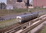 Image 14746 (292k, 1024x668) Photo by: Joe Testagrose Location: Jefferson Park |  Image 14749 (193k, 1024x683) Photo by: Joe Testagrose Location: Jefferson Park |  Image 14976 (75k, 640x411) Photo by: David S. Cole Location: Paulina Connector |
Photos By Location
Photo locations: O'Hare, Rosemont, Cumberland, Harlem, Jefferson Park, Montrose, Irving Park, Addison, Belmont, Logan Square, Logan Square (Abandoned), California, Western, Damen, Dearborn Portal, Division, Chicago, Grand, Clark/Lake, Washington, Monroe, Jackson, LaSalle, Clinton, UIC/Halsted, Racine, Paulina Connector, Medical Center, Western, Kedzie-Homan, Pulaski, Cicero, Lotus Tunnel (under I-290), Austin, Oak Park, Harlem, Forest Park
Page Credits
By David S. Cole