CTA Red Line
![]()
The Jackson station on the Red Line's State Street Subway. Photo by David Pirmann, April 2005.
Overview
The State Street Subway begins just south of the Armitage station on the CTA North Side Main Line. The Red Line uses the middle tracks of the L, which dip down between the outer tracks and enter the subway at Willow Avenue. Shortly after the portals, we curve toward the southeast and enter the station at North / Clybourn (1600N / 800W). This station, the first of many subway stops on our journey, is probably the most unique subway station in the system. The side platforms are of fairly typical construction, with vaulted ceilings and a row of structural columns about four feet in from the platform edge. However, fare control is located in a large station house at street level, as opposed to a mezzanine below-grade. Stairs, escalators, and a short passageway connect the platforms with the station house. The station house is pie-shaped to fit the triangular site, with the station entry along the curve. The tip of the "pie" contains a small retail space. North / Clybourn serves the busy intersection of North and Clybourn Avenues, and Dayton Street. A stairway from Dayton Street still exists, but has been covered up. The surrounding neighborhood is an interesting mix of retail, residential lofts, trendy nightclubs, and some light industry.
We are now travelling under Clybourn Avenue, one of the few diagonal streets in Chicago. We pick up a bit of speed, as it will be several blocks before our next station stop. We can't see it from here, but above our heads is the Cabrini-Green complex, one of the more notorious public housing projects in Chicago.
Our tracks curve toward the east, and we are now travelling under Division Street. We pass through a crossover chamber before arriving at Clark / Division (1200N / 100W), our next stop. Clark / Division has an island platform, with fare control on a mezzanine above. Stairs and an escalator provide access to and from the platforms. From the mezzanine, passages lead to all four corners of the intersection of Clark Street and Division Street. This part of town is in the Gold Coast, and is home to a number of touristy bars, restaurants, and clubs.
Just beyond the station, the tracks curve sharply to the south, placing us under State Street. State Street serves as the north-south axis of the city's street numbering system, officially dividing "east" from "west" in Chicago.
Our next stop is Chicago (800N / 1E/1W). This busy station serves the active Streeterville neighborhood, and provides access to the North Michigan Avenue shopping district a couple blocks to the east. Loyola University's downtown campus, the historic Water Tower, and the John Hancock Center are all nearby. In response to high traffic here, the station is in the midst of a massive reconstruction project. The mezzanine is being enlarged to almost twice its previous size, new stairs and escalators are being installed, and the side platforms are receiving new, brighter architectural treatments that include decorative tilework. Elevators have been added to make the station ADA-compliant. Despite what many tourists seem to think, the station name refers not to the city of Chicago, but its location at Chicago Avenue.
Continuing southbound, our next stop is Grand (550N / 1E/1W). Grand is almost identical to what the Chicago station used to be before renovations began, a standard-issue CTA design with two side platforms and fare control on a mezzanine above. The station, serving the trendy River North district of restaurants and bars as well as a number of office buildings, seems a bit rundown and deserves a good cleaning at the very least. The station at one point had another entry at Ohio Street to the north, but this entry has been long abandoned even though signs on the platforms still point to it. Commuters get a bit of a chuckle when the train's automated announcement system announces "This is Grand" in a cheery radio-announcer voice.
We continue southward, passing through another crossover chamber just beyond the station before ducking under the Chicago River. Once on the other side of the river, we enter a series of stations that is unique to Chicago, essentially a single long subway station that stretches the entire length of the Loop. The center platform is several blocks long, with entrances at every block along its length. Trains stop at various locations along the platform, each stop named after whatever east-west cross street is above. Stations along this section feature vaulted ceilings painted white, with blue acoustical panels on the walls next to the tracks. Each "stop" in this section is served by a mezzanine at each end of the stop, although some mezzanines are exit-only.
Our first stop in this section is Lake (200N / 1E/1W). This station provides a paper transfer to the Green, Orange, Brown and Purple lines on The Loop above at State/Lake.
A short distance further south is Washington (100N / 1E/1W). The mezzanine of this station was recently enlarged, and elevators and new escalators installed. New tilework is similar to the tilework we saw being installed at Chicago Avenue. This station provides a transfer to the Blue Line via a block-long passageway to the CTA Blue Line's Dearborn Street Subway</a>, essentially a carbon copy of the State Street Subway. This station also provides Pedway access to Marshall Field's department store, the Metra Electric terminal at Randolph Street, as well as the nearby City Hall and government office buildings.
Next is Monroe (100S / 1E/1W), a rather poorly-lit section of the State Street "infinite platform."
Next is Jackson (300S / 1E/1W). Similar to Washington, Jackson also includes a transfer tunnel to the Blue Line. Jackson also serves the federal office buildings as well as the downtown campus of DePaul University.
After Jackson, we leave the continuous station and head back into the darkness of the subway tunnel. Our next stop is Harrison (600S / 1E/1W). This nondescript station has an island platform with fare control on a mezzanine toward the north end of the station. Harrison is convenient to the historic Printer's Row district a block west of us on Dearborn Street.
Next is Roosevelt (1200S / 1E/1W). This station, like Harrison before, is an island platform station with a mezzanine at one end, this case the south end. This station was recently renovated, with an elevator added and decorative tilework added to most surfaces. This station is only a half-block west of the Roosevelt elevated station on the CTA Green Line and CTA Orange Line, and a free transfer is provided. This station provides access to the up-and-coming South Loop area, as well as Soldier Field and the new Museum Campus on the lakefront. West of here on Roosevelt Road is a long overpass which provides excellent views of a large rail yard used by Metra and Amtrak.
Just south of Roosevelt, we see a set of tracks split off toward the left. These lead to the elevated tracks now used by the Green and Orange lines, and were used back when trains from Howard were routed to the elevated instead of the Dan Ryan line. These tracks are no longer used for regular revenue service, but are sometimes used for non-revenue equipment moves.
Our tracks gently curve toward the west before heading onward to the median Dan Ryan Expressway.
Emerging from the subway portal, we find ourselves passing through the midst of the "Frontier", a large area of vacant land south of the Loop consisting mainly of tall grass, a few clusters of trees, makeshift camps in which homeless people reside, and a mishmash of various railroad tracks. It seems an unusual landscape given its close proximity to the Chicago Loop. We soon pass under the long viaduct which carries the CTA Orange Line to and from Midway Airport. A pair of tracks descend from the viaduct and join our tracks, connecting the Dan Ryan line to the viaduct. This connection is used when Red Line trains are occasionally routed "over the top" via the downtown el as opposed to the subway. Such reroutes are rare, but happen every so often due to maintenance work or an emergency in the subway.
The tracks gently rise up onto an embankment before we reach our first stop on this branch of the Red Line, Cermak-Chinatown (2200S / 200W). This station, like all the other stations from here until the end of the line at 95th Street, is of a fairly modern design, dating from the mid 1970's when this branch was constructed. Typical of these stations, the Cermak-Chinatown stop features an island platform with a granite floor and a long plexiglass-and-steel canopy stretching the entire length of the slightly-curved platform, supported by a single row of steel columns down the center. All metal surfaces are painted white, with a red stripe on the columns. Cermak-Chinatown is above street level, with fare control at the south end of the platform. Escalators and stairs provide access to both sides of the street below.
To our right we see the colorful Chinatown business district, set amidst the numerous railroad tracks that feed into Union Station and several nearby rail yards. A new park has recently been completed on the bank of the Chicago River nearby, providing an excellent vantage point to watch the surrounding rail traffic before enjoying a meal in one of the neighborhood's excellent Asian restuarants.
As our train pulls out of the station, we find ourselves passing through the median of a short connector highway that leads to the Dan Ryan Expressway. After passing through the middle of a complicated interchange with the Stevenson Expressway, we go through a short tunnel before emerging in the median of the Dan Ryan Expressway. The Dan Ryan was one of the first major Chicago expressways to be built and among the first great public works projects built by the late mayor Richard J. Daley. The Dan Ryan has somewhat of a notorious reputation for the fact that it forms the western boundary of the so-called "State Street Corridor" an immense wall of Chicago Housing Authority towers that stretches over four miles long and forms the densest concentration of public housing in the nation. The location of the Dan Ryan was deliberately planned to reinforce Chicago's racial boundaries; during the early phases of design, its location was shifted several blocks east to form a more effective barrier between the largely black South Side ghetto and the largely white working-class neighborhood of Bridgeport to the west. At the time of its completion, the Dan Ryan ranked as the widest expressway in the world -- 14 lanes of traffic divided into three express lanes and four local lanes in each direction, with the rapid transit line down the median -- and still ranks as one of the busiest. In addition, the Rock Island District commuter trains run on a raised embankment alongside the expressway, just between the expressway and the housing projects. The railroad viaduct further reinforces the massive barrier this expressway creates.
To our left is the Hilliard Center, the last of several public housing projects to be built along the State Street Corridor by Richard J. Daley. The Hilliard Center features a more distinctive design than the other projects nearby; designed by renowned architect Bertrand Goldberg, the project features two crescent-shaped towers for family housing and two cylindrical towers for elderly housing. This forms the beginning of a continuous wall of public housing from here to Garfield Boulevard, interrupted only by the Illinois Institute of Technology campus, visible on the left as we approach the next station at Sox-35th (3500S / 200W). This station, like all the others until the end of the line, is an island platform station located in the median of the expressway. Access to the platform is by means of a mezzanine at the level of the street overpasses, with stairs and escalators leading to the platform. The main fare control area is on the mezzanine at 35th Street at the south end of the platform, with a secondary entrance/exit on the north end of the platform which leads to 33rd Street. This secondary entry has no ticket agent, only a so-called "iron maiden" that prevents turnstile-jumping. To our left, beyond the Rock Island viaduct, is the Mies Van Der Rohe-designed campus of the Illinois Institute of Technology. The IIT campus is also served by the 35th-IIT-Bronzeville stop on the CTA Green Line, running parallel to us only a couple blocks to the east. To our left is the new Comiskey Park, home of the Chicago White Sox and a vertigo-inducing upper deck of seating.
Pulling out of the station, we see the Stateway Gardens projects on the left, typical of the public housing that dominates our eastern vista from here until Garfield Boulevard. After Stateway Gardens are the notorious Robert Taylor Homes, the single largest public housing development in the world and among the most plagued by drugs and gang violence. Hard lessons about public housing policy have been learned over the years, and the high-rise towers of Stateway Gardens and Robert Taylor are slowly being demolished and replaced by low-rise townhouses, mixed-income housing, and Section 8 vouchers for private housing. However, it is a long process and it will be many years before the last of these towers finally come down.
The next stop is 47th/Wentworth (4700S / 200W). Fare control is on a mezzanine at the south end of the platform. Typical of stations along this line, 47th/Wentworth features a granite island platform with a plexiglass canopy supported slender steel columns. The platform is slightly curved to follow the curve of the expressway as it jogs slightly to the west. This station serves as a terminal and transfer point for several South Side bus routes.
The following stop is Garfield (5500S / 200W). This stop is almost identical to 47th/Wentworth. We now find ourselves at the end of the four miles of public housing projects; to our left across the expressway is a large rail yard and maintenance facility which serves the Rock Island commuter trains. About a half-mile south of Garfield, the Englewood branch of the CTA Green Line passes over the expressway before turning south and following alongside the expressway for a few blocks before heading west toward its terminal at Ashland Avenue.
63rd (6300S / 200W) is our next stop. Fare control is at the south end of the platform, at platform level. At this point in the Dan Ryan Expressway, the express lanes merge into the local lanes. South of 63rd Street, the Rock Island tracks pass over us as they cross the expressway, and exit ramps for the Chicago Skyway branch off toward the southeast. Meanwhile, the expressway shifts a block or so toward the east and under Wentworth Avenue, coming up alongside State Street.
The next stop is 69th (6900S / 1W). Fare control is on a mezzanine at the south end of the platform. A dedicated overpass for busses alongside 69th Street makes this station another major transfer point for several bus routes.
79th (7900S / 1W) is next, and is very similar to 69th. The only major difference is that this station is the only one on this branch that also includes an elevator for wheelchair access to the platform level.
87th (8700S / 1W) is the next-to-last stop on this line, and has fare control at the north end of the platform level. On either side of the expressway at street level are shopping centers featuring a number of newer "big-box" retailers, providing welcome access to merchandise and entry-level jobs in an area of the city that had traditionally been neglected for years by the national retail chains.
We soon pull into the terminal at 95th/Dan Ryan (9500S / 1W). This is a typical island platform station with a plexiglass canopy (badly in need of cleaning), except with an unusually wide platform as well as facilities for CTA employees. Fare control is on a large mezzanine above, with three entrances that serve the various bus drop-off and loading areas. This is a major transfer point between several CTA and Pace bus routes, with a large bus shelter on each side of the expressway with a dedicated overpass connecting them. The mezzanine features a number of small retail outlets, including a Dunkin Donuts and a newstand.
Beyond the station is a rail yard used for storage of off-duty trains, and the CTA has long-term plans to extend the Red Line southward to 106th Street, providing rapid transit access to Chicago State University and Olive Harvey College. In fact, the expressway was specifically designed to allow for rapid transit service down the median. However, this extension remains in the study phase and there is currently no funding in place for further design or construction.
Photo Gallery
| Five Random Images | ||||
 Image 22791 (164k, 1044x788) Photo by: David Pirmann Location: Grand | 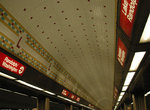 Image 54236 (212k, 864x574) Photo by: Peter Ehrlich Location: Lake |  Image 84579 (247k, 1044x788) Photo by: David Pirmann Location: Harrison |  Image 84582 (229k, 1044x788) Photo by: David Pirmann Location: Jackson |  Image 149963 (745k, 1600x1067) Photo by: Gerald H. Landau Collection of: David Pirmann Location: 95th/Dan Ryan |
Photos By Location
Photo locations: North/Clybourn, Clark/Division, Chicago, Grand, Lake, Washington, Madison, Monroe, Jackson, Harrison, Roosevelt, State Street Subway, 13th & State Portal, Cermak/Chinatown, Sox/35th, 47th/Wentworth, Garfield, 63rd, 69th, 79th, 87th, 95th/Dan Ryan
Page Credits
By David S. Cole