CTA Green Line
![]()
CTA 2400 Series 2439 north of IIT on the Green Line. Photo by David Pirmann, May 2008.
Overview
On this trip we will be exploring one of the oldest rapid transit lines in Chicago, the Green Line. The Green Line is the only CTA line that stays elevated above street level from start to finish, and has also experienced the most extensive changes since its construction. Once in an extreme state of disrepair, the entire line was shut down in 1994 for a four-year reconstruction project. The reconstruction included new foundations for the elevated structure, repairs to the steelwork where needed, a new signalling system, and a total reconstruction of almost all stations. For the most part the reconstruction has been a success, with the line now among the fastest and most modern of the CTA system. However, the line being closed for three years took a huge bite out of ridership, which has yet to recover. Lessons were learned, and the CTA has decided that the Douglas branch of the Blue Line will remain open while it undergoes a similar reconstruction beginning in late 2001.
The line begins its journey in the quaint business district of Oak Park, a leafy suburb with a pedestrian-friendly, urban feel and also home to noted architect Frank Lloyd Wright for many years. Many houses designed by him still dot the city's neighborhoods. The CTA terminal at Harlem / Lake (1200W / 100S) is adjacent to the Oak Park commuter rail station, served by Metra's Union Pacific West Line. CTA trains share the same embankment as Metra trains here, the two ROW's seperated only by a chain-link fence. The CTA terminal consists of an average-sized island platform covered by a long canopy. A rail yard and maintenance facility sit to the west of the station. A large new station house is at the east end of the platform, with fare control at street level below. This fare control area opens up to a concourse which passes under the viaduct and also provides access to the Metra platforms to the north. Also at this entry is an undalating canopy that shelters a small bus loading area. The original station house at the western end of the platform is very small and cramped, and is now used as a secondary entrance.
The surrounding business district is very active, reminding us of the Evanston business district on the Purple Line. Small shops, cafes, and restaurants line the sidewalks.
Departing the Harlem / Lake terminal, we soon encounter the station at Oak Park (800W / 100S), the first of three nearly-identical stations in a row. Stairs and an escalator connect the wooden island platform with the fare control area below. The Metra tracks are just to our left, still sharing the same embankment in an arrangement similar to what we find on the Purple Line south of downtown Evanston.
The next two stations, Ridgeland (400W / 100S) and Austin (6000W / 400N) are essentially carbon copies of Oak Park. The change in the street numbering sequence at Austin indicates that we are now within the city limits of Chicago.
Our next stop is Central (5600W / 400N), very similar to the previous three stops except with a larger platform. Soon after leaving Central, we jog slightly to the south, leaving the embankment behind in favor of a steel elevated structure that will carry us all the way to the Loop and South Side.
Our next station is Laramie (5200W / 400N), with side platforms connected by a crossover.
The next stop, Cicero (4800W / 300N), has an island platform. A large, modern station house sits on the northeast corner of Lake and Cicero, connected to the platform by stairs and an elevator via a bridge that passes under the outbound track. The large factory off to our left is the Brach's candy factory, slated for closing soon.
We cross over a railroad viaduct before entering the next station at Pulaski (4000W / 300N). This unusual station received two new side platforms as part of the Green Line reconstruction, but for a couple years fare control was located in rickety station houses at platform level. These station houses are connected to their respective platforms by wooden walkways alongside the tracks. It wasn't until some time later that this station had a new station house built on each platform, along with a canopy and crossover. The new elements are similar to those of the other stops we have passed so far. The temporary walkways station houses still exist at the east end of the platforms, but are now disused and blocked off.
Our next stop is the newest station in the CTA system, Conservatory - Central Park Drive (3600W / 300N). Like the other stations on the Green Line, the side platforms are of a fairly modern and Spartan design, with stairs and elevators leading to street level below. The station houses, however, are historic station houses that have been beautifully reconstructed. The fare control areas, at platform level, feature attractive hardwood surfaces and sensitive lighting. The exteriors are painted white with green trim, keeping with the Green Line theme and also recalling the liveries of previous generations of CTA rolling stock. A crossover connects the two platforms, but is for employee use only. In an unusual departure from typical CTA practice, only the inbound platform has a ticket agent. The outbound platform has only the turnstiles, but the fare control area is clearly visible from the ticket agent's position on the inbound platform.
Visible on either side of us is beautiful Garfield Park, with the large Garfield Park Conservatory just off to our left. The construction of the new station here is partly an effort by the city to boost the popularity of the conservatory. The conservatory suffers the misfortune of being located on the blighted West Side, which strikes fear in the hearts of many tourists. This is in comparison to the popular Lincoln Park Conservatory, which is located in fashionable Lincoln Park.
Our next station is Kedzie (3200W / 200N). This is a large station with side platforms and a crossover.
The next stop, California (2800W / 120N), is very similar. We cross yet another railroad viaduct and pass the Henry Horner Homes to our right. Henry Horner ranks with Cabrini-Green and Robert Taylor Homes as one of the more dangerous public housing projects in the city. However, many of Henry Horner's high-rise towers have already been replaced with low-rise housing designed to re-create a more traditional neighborhood atmosphere. Some of these low-rise townhouses are visible just to our right. The United Center, home of the Chicago Bulls and Blackhawks, is a couple blocks to our south.
Soon, we see an L structure with two tracks joining our L from the right. This structure, now referred to as the Paulina Connector, used to continue north of here and join what is now the O'Hare branch of the Blue Line right around where today's subway portal is at Paulina. The only remnant of that section visible today is the bridge that once carried it over the large railroad viaduct that feeds into North Western Station and Union Station. The bridge now literally leads from nowhere to nowhere, but does serve as a handy signal bridge for the railroad. Trains from the CTA Pink Line join the Green line L at this point. This structure is the Pink and Blue Lines' only connection with the rest of the CTA system.
Moving onward, we approach the station at Ashland (1600W / 200N). This station is very similar to the newer Conservatory station, with historic station houses on each of the side platforms that have been sensitively rebuilt. A crossover connects the two platforms.
Leaving Ashland behind us, we are barreling rapidly toward the great wall of Loop skyscrapers. Just a couple blocks to our north is the Fulton Street Market area, the city's wholesale distribution area for meat and other food products. While not as historically quaint as London's Smithfield Market, the Fulton Street area is still an impressive sight early in the morning when the activity is at its peak. During off periods, this section of the city forms an eerie industrial landscape that appears to have been imported from an Edward Hopper painting. Residential loft conversions are rapidly changing the area, especially as we get closer to the Loop, and this area has also become a popular location for trendy after-hours nightclubs. One such club, located almost directly under the L on Lake Street, is appropriately named Transit.
Almost in the Loop itself, we enter the station at Clinton (540W / 200N). This is an unusually high station because the L must pass over the large viaduct that feeds into the busy Chicago and North Western commuter rail terminal. Like most of the other stations on the Lake Street "L" so far, Clinton has side platforms and has been newly reconstructed as part of the Green Line rehabilitation. Fare control is located on a mezzanine below, with stairs and long ramps connecting the mezzanine to the platforms. An elevator and long stairways provide access to the street level. This station is mostly used as a convenient transfer point to the C&NW trains, but the surrounding area is also seeing a great deal of office and residential loft development.
Leaving Clinton, we cross over the C&NW tracks and then, half a block later, cross over the south branch of the Chicago River via the Lake Street Bridge. We are treated to a spectacular view up and down the river as we cross over one of the two downtown drawbridges that carry "L" tracks. Looking off to our left and up the river, we see the gargantuan Merchandise Mart, the largest building in the world when completed in 1931 and designed by the Chicago firm of Graham, Anderson, Probst and White. Even today, only the Pentagon is larger. The Mart contains mostly interior design showrooms, a retail mall, and the CTA headquarters.
Behind us to our right is 100 North Riverside Plaza, a blue and gray building with a tall clock tower. Designed by noted architect Ralph Johnson of Perkins & Will, 100 North Riverside was formerly the home of Morton International, and is now the new headquarters for the Boeing corporation. The southwest corner of the building is actually suspended by a massive steel truss over the railroad tracks that feed into Union Station, since there was no space among the tracks for structural columns. The steel truss is plainly visible above the roof of the low-rise portion of the building, recalling the steelwork of the muscular drawbridges that span the river.
Looking to our left, we see the Sears Tower dominating the southern vista. Still arguably the world's tallest building (depending on what criteria you chose to employ), the Sears Tower visually anchors the southern portion of the Chicago skyline. The building was designed by the Chicago office of Skidmore, Owings and Merrill, the same firm that has designed numerous other Chicago skyscrapers including the Sears Tower's older cousin on the Near North Side, the John Hancock Center.
Next to the "L" on the east side of the river, to our left, is a greenish, glassy office building that ranks as one of Chicago's most famous modern landmarks. 333 West Wacker, as the building is called, was designed by the firm Kohn Pederson Fox and was completed in the early 1980's. The building sits on an awkwardly-shaped city block, but beautifully responds to its site with a shimmering glass wall that follows the curve of the Chicago River.
Now on the east side of the river, we are approaching the "grand junction" at Tower 18 and the Loop proper. Once past Tower 18, we will make the following stops before continuing onward to the South Side: Clark / Lake, State / Lake, Washington / Wabash, Adams / Wabash. See The Loop section for details on these stations.
Leaving the Loop and travelling southbound above Wabash Avenue, we pass through an area of downtown that contains an eclectic mix of office buildings, hotels, and university buildings. DePaul University, Roosevelt University, and Columbia College each have a significant presence in this area. Approaching Harrison Street, we squeal our way through a very tight S-curve as the tracks jog over to an alley between Wabash and State. This is one of the tightest curves in the CTA system, and trains must slow to a crawl to pass through it. Surface parking lots lie on each side of the tracks here, so it begs the question of why the CTA hasn't acted to lessen the curve at this point. The large red brick building off to our left is the Chicago Hilton and Towers, formerly the Conrad Hilton. This hotel, the largest in the world when constructed, was made famous by the "police riot" that occurred during the 1968 Democratic Convention. Chicago police tossed anti-war activists through the hotel's plate glass windows as the TV cameras looked on and as protesters chanted "The world is watching."
Southbound from Harrison, we pass between several older buildings, some of which have been converted to upscale lofts. Along this portion the L passes very closely between the buildings, sometimes with only a few inches to spare. Emerging from this urban thicket, we arrive at the Roosevelt (1200S/16E) station. We share this large station with the CTA Orange Line, and the CTA Red Line subway stop is only a half-block to the west. Roosevelt is a relatively new station, with a long island platform made of concrete. Stairs and an elevator leading to a modern station house below, which opens to the north side of Roosevelt Road.
Looking to our right, we see the new Roosevelt Road bridge over the Chicago River and the large rail yards leading into Union Station. Looking to the left, we can see the new Museum Campus and Soldier Field. This area of Chicago has seen dramatic changes in recent years. Once considered a no-man's-land, the South Loop has seen a dramatic infusion of upscale townhouses and loft conversions in recent years.
Leaving Roosevelt, we soon see the tracks coming up from the Red Line subway and joining our tracks. This connection is now only used for occasional non-revenue equipment moves, but was used in revenue service until the early 1990's when the Howard line ran via the South Side L as opposed to the Dan Ryan Expressway. Soon after the subway tracks join us, the Orange Line branches off toward Midway Airport via the CTA's only flying junction. We continue due south toward the South Side.
We pick up a bit of speed as the train enters a long stretch of track with no stations. Like the Lake Street branch of the Green Line, this branch also received a massive reconstruction in the mid-1990's. Hence, most of the stations we will encounter are of a functional if uninspiring new design, with elevators and escalators.
To our right we see an interesting cluster of curvilinear high-rise buildings designed by noted architect Bertrand Goldberg. This public housing project, the Raymond Hilliard Homes, is one of the more successful high-rise projects in Chicago. The two cylindrical buildings are for senior citizens, while the two taller buildings are for family housing. This is the first portion of a nearly six-mile corridor of public housing along the so-called State Street Corridor, the largest concentration of public housing in the nation. These same projects are visible from the Dan Ryan branch of the CTA Red Line, which runs parallel to us only a couple blocks to the west.
In the distance to our left is McCormick Place, a massive convention center that occupies three separate buildings connected by a soaring concourse. The original building was built on the lakefront with heavy political pressure from the Chicago Tribune, in violation of Daniel Burnham's dictum that Chicago's public lakefront remains "forever open, forever free" of development. The original building burned down under mysterious circumstances in a spectacular fire shortly after it was completed. Today's Lakeside Center building stands on that site. In subsequent years, Lakeside Center has been joined by two large exposition halls, the concourse, and a large Hyatt hotel. Today, McCormick Place is by far the largest convention center in the world, making Chicago a popular destination for trade shows and conventions.
We soon pass over the Stevenson Expressway just a couple blocks east of its complicated interchange with the Dan Ryan Expressway. Once south of the expressway, we enter a continuous stretch of public housing, vacant lots, and the occasional church. One church along this route is where Gospel music was born, the result of a pastor's attempt to spice up Sunday morning worship services by combining elements of African-American spirituals and electrified blues. Of course, the blues genre itself has deep roots in Chicago and in this neighborhood in particular, brought here by former slaves arriving from the Mississippi Delta region during the Great Migration. Chicago-style blues is as much a part of Chicago's identity as jazz is to New York.
This stretch is interrupted only by the campus of the Illinois Institute of Technology, which our ROW bisects. This campus was designed by Mies Van Der Rohe shortly after becoming head of the school's architecture program. Cold and lifeless to some, the IIT campus is a showcase of the master architect's crisp modernist style and contains a number of notable buildings. The most famous of these buildings is Crown Hall, which houses IIT's school of architecture. The building is beautifully proportioned and made almost entirely of glass and steel. The airy structure resembles a jewel box and has a very modern feel to it. It is hard to imagine this building is almost fifty years old.
The section of campus west of State Street contains the bulk of the campus and most of the landmark Mies buildings. The eastern portion of the campus contains mostly housing and student services, with parking lots directly adjacent to and below the CTA structure. However, IIT is in the midst of a major capital improvement program which includes a large new student center directly below the "L" structure. This student center, now under construction, is designed by noted Dutch architect Rem Koolhaas. The project was the subject of a well-publicized design competition, with the Koolhaas scheme beating out other schemes designed by architects such as Helmut Jahn and Zaha Hadid. The new building will be a single-story structure, with interior corridors based on the paths students took while walking across the parking lot that previously occupied the site. Of particular interest to transit buffs, the building will feature a large metal tube that will surround the entire "L" structure along the length of the building. Trains will pass through the tube itself, the idea being that the noise from the passing trains will be somewhat shielded by the tube.
The IIT campus is served by the 35th/IIT/Bronzeville (3500S/16E), our first station after the long run south of Roosevelt. This station features a long, narrow concrete platform, with the station house facing 35th Street. An escalator, stair, and elevator connect the station house to the south end of the platform. An additional stairway at the north end of the platform leads to a single "iron maiden" high-level turnstile below. Once the new student center is complete, it will feature a dedicated entry to the station, presumably with an additional fare control area.
Leaving the station, we see the large new Chicago Police Department headquarters off toward the left, designed by the respected Chicago architecture firm Lohan Associates. A center layup track briefly appears just to our left, and we marvel at the great wall of public housing just across State Street to our right. Appearing like something out of the old Soviet Union, mile after mile of high-rise public housing serves as a monument to good intentions gone bad. Beginning at 35th Street with Stateway Gardens and followed by the infamous Robert Taylor Homes, this area is among the most plagued by drugs and gang violence in the city. These high-rises are slowly being torn down and replaced by scattered-site, low-rise housing and Section 8 vouchers, but it is a long process and won't be complete for years.
A little less than a mile south of 35th Street, we make a 90-degree turn toward the east. We notice the curved section of track is supported by concrete columns that appear newer than the rest of the structure. Just after the curve, we enter the station at Indiana (4000S/200E). This modern station has side platforms and new elevators at the east end of the platforms. Fare control is in a new station house on the east side of Indiana Avenue below. Leaving the station, we curve sharply toward the south and continue in our original southbound direction. The Sheridan stop on the Red Line is the only other location on the "L" where we find a station in the middle of an S-curve in this fashion.
It was at this location where two former branches of the South Side "L" branched off from the mainline. The Stockyards branch travelled west from here to the famous Union Stockyards, making a one-way loop around the stockyards themselves before returning to the mainline. The Kenwood branch went east of here alongside the Chicago Junction Railway to the Kenwood neighborhood. Both of these short branches were shut down in the 1950's, and little of them remains today.
Continuing southward, we are travelling over an alley a half-block east of Indiana Avenue. The looming towers of the Robert Taylor homes are still visible to the west, but are now further away from us. Our next stop is 43rd (4300S / 300E). This station has side platforms, with stairs and elevators leading to fare control below, on the north side of 43rd Street. A crossover connects the two platforms.
Moving onward, we can't help but notice the vast amount of vacant land in this area. The City of Chicago has an aggressive policy of demolishing abandoned buildings in oder to prevent them from becoming crack houses or squatter settlements. This has resulted in some blocks to be almost completely cleared. However, this has prompted some to complain that scores of historic, structurally sound buildings are being destroyed that could otherwise be rehabilitated into affordable housing. Our next stop, 47th (4700S/300E), is nearly a carbon copy of the previous station at 43rd.
South of 47th, the tracks jog slightly to the east before we enter the station at 51st (5100S/300E). This station is very similar to the previous two, except that the elevator to the southbound platform from the crossover is cantilevered directly above the street itself.
The next stop is Garfield (5500S/300E), one of the most rundown and decrepit stations in the CTA system. Wooden side platforms are enclosed by chain-link fencing, and are connected to a tired station house below by narrow, rickety stairways.
South of Garfield, we pass an abandoned station at 58th Street with a wooden island platform. The station, renovated as recently as the 1980's, was closed during the Green Line reconstruction and never re-opened. Another abandoned station was located at 61st Street, closed in 1994 during the Jackson Park branch renovations and never reopened. A short distance beyond this abandoned station, we see the Englewood branch tracks veer off toward the west. See the Englewood branch section for a description for this branch.
Shortly beyond this junction, we see a fairly large CTA rail yard and maintenance facility to our left. The entire yard is elevated above street level, similar to the old Wilson Shops complex on the Red Line. We pass the yard and curve toward the east, around the yard's southern end. Looking to our right as we round the curve, we see a connection to the mainline railroad and a large storage area filled with ties and other ROW materials.
Now heading east above East 63rd Street, we soon enter the station at King Drive (6300S/400E). This modern station features side platforms, with fare control at platform level on each side. A crossover connects the two platforms.
Moving onward, we enter our final station at Cottage Grove / East 63rd (6300S/800E). This station is nearly identical to King Drive, except that the outbound platform is exit-only and that the station has been slightly modified into a terminal station. The line used to extend all the way to the Illinois Central (now Metra Electric) line near Jackson Park on the lakeshore, but has been cut back over the years to University Avenue and then to Cottage Grove. The demolition of the "L" structure between Cottage Grove and University Avenue occurred toward the end of the reconstruction period due to neighborhood pressure. The Cottage Grove station was then converted to a makeshift terminal station, but remnants of the concrete foundations of the "L" structure are still visible in the sidewalks along East 63rd Street. Perhaps one day the Jackson Park "L" will once again go to Jackson Park, but it probably won't happen in the foreseeable future.
Shortly after turning onto the Englewood branch is the location of a former station at State (5950S? / 0E/0W). Probably closed in 1994 during the Green Line rehabilitation program. Two other abandoned stations, Wentworth and Harvard, follow, before arriving at the next in-service station at Halsted.
Branching off the mainline, we curve toward the west and run above an alley for a couple blocks before our tracks rise up to pass over the Rock Island viaduct and then the wide expanse of the Dan Ryan Expressway. Looking down from the train, we see the tracks of the CTA Red Line (Dan Ryan Branch) in the median below. Just west of the expressway, we turn south and travel parallel to the expressway for a couple blocks. It was around this area that the very short Normal Park branch began, travelling less than a mile and serving a single station at 69th Street. That branch was shut down years ago, and little evidence of it remains. We cross over another railroad viaduct before curving again to the west, and then cross over yet another railroad viaduct via a steel truss bridge. The forgotten remnants of a former station are visible alongside the tracks below, with rusted canopies sheltering the weeds growing through the cracks on the platforms. We are now travelling above West 63rd Street.
We approach our first of two stations on this branch, Halsted (6300S/800W). This renovated station features side platforms, with elevators at the west end of each platform. The design of the station is similar to that of the other Green Line stations we have encountered so far.
After Halsted we pass an abandoned station at Racine (6300S/1200W), and a yard on the south side of the tracks. The station was closed in 1994 during the Green Line rehabilitation program, but unlike a few others along the line, was not demolished.
We pass an island platform station before shifting slightly to the north, indicating the old Loomis terminal. We pass another abandoned station at Racine with side platforms, and then see a small rail yard to our left. Before long, we enter the station at Ashland / 63rd (6300S/1600W). This station was built in the late 1960's when the line was extended a few blocks west of Loomis, and features a somewhat dated-looking design that probably looked very modern when completed. The station has an island platform, sheltered by concrete canopy that cantilevers over the tracks in a gull-wing shape. A tower is above the east end of the platform, connected to the platform via a small stairway. Fare control is at street level below, along with a bus loading area covered by a glassy canopy and a small Park-'n'-Ride lot. A new elevator has been installed here, making the station ADA-compliant. A small yard lies just to the west of the station. We are in the heart of the Englewood business district, which has suffered from years of blight and disinvestment. However, a diverse selection of retailers, mostly catering to the neighborhood's low-income residents, still occupies 63rd Street nearby.
Photo Gallery
| Five Random Images | ||||
 Image 14359 (213k, 1024x682) Photo by: Steve Zabel Collection of: Joe Testagrose Location: Pulaski | 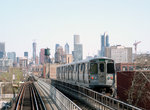 Image 84088 (257k, 1044x701) Photo by: David Pirmann Location: 35th/IIT/Bronzeville |  Image 84114 (308k, 1044x701) Photo by: David Pirmann Location: 43rd |  Image 84323 (395k, 1044x701) Photo by: David Pirmann Location: Indiana |  Image 140325 (379k, 1044x703) Photo by: David Pirmann Location: Indiana |
Photos By Location
Photo locations: Harlem/Lake, Oak Park, Ridgeland, Austin, Central, Laramie, Cicero, Pulaski, Conservatory/Central Park Drive, Homan, Kedzie, California, Ashland, Halsted, Clinton, Lake Bridge, Harrison Curve (Harrison & Wabash), Roosevelt, 17th Junction (Orange/Green), 35th/IIT/Bronzeville, Indiana, 43rd, 47th, 51st, Garfield, 58th (Abandoned), 59th/Prarie Junction, 61st Street (Abandoned), 63rd Street Yard, King Drive, Cottage Grove/East 63rd, University (Abandoned), Dorchester (Abandoned), Dorchester Bridge (Abandoned), Stony Island (Abandoned), Jackson Park (Abandoned), State, Princeton (Abandoned), Wentworth (Abandoned), Harvard (Abandoned), Parnell (Abandoned), Halsted, Racine, Racine Yard, Ashland/63rd, (Misc/Unknown)
Page Credits
By David S. Cole