CTA Pink Line
![]()
CTA 2600 Series 3107 at 54th/Cermak on the Pink Line. Photo by David Pirmann, May 2008.
Overview
The Pink line is a new service utilizing the Douglas Park branch, formerly of the Blue Line, the previously non-revenue Paulina Connector, which was heavily rebuilt for Pink Line service, the Green Line from Ashland east, and the Loop, where the line runs clockwise. The stations along the Douglas Park branch underwent a major reconstruction beginning in late 2001 and is still ongoing. Unlike the similar rehabilitation of the Green Line in the early 1990's, the Douglas branch remained open during construction. The end result, however, is expected to look much like the newly-renovated Green Line, with a reconstructed elevated structure and new, larger stations that feature elevators for improved accessibility. The descriptions below may reflect conditions before, or after, the rehabilitation project.
During rush hours, through service also operates on the Douglas Park branch to and from the Blue Line to O'Hare. As the stations on the Green line and Loop portion of the Pink line are described in those sections, we will start our description of the Douglas branch west of Racine on the Blue line.
The Douglas branch begins as we split from the Congress branch just west of Racine and climb up the "Angel's Flight" ramp in the median of the Eisenhower Expressway. As we reach the top of the ramp, we are treated to an impressive view of Chicago's Near West Side. The tracks are only about 15 feet above Chicago's regular street level, typical for an el, but since the expressway is in an open cut about 20 feet below street level, our tracks are actually about 35 feet above the ground. We cross over Ashland Avenue and approach Paulina Avenue. To our right we see the Paulina Connector heading off toward the north, eventually joining the Lake Street "L" about a mile away.
Once we reach the connector track, we curve sharply to the south and cross over Paulina Avenue and the eastbound lanes of the expressway. Almost immediately, we find ourselves passing through a large wing of Rush-Presbyterian Medical Center. The hospital wing, built in the 1980's, was built on either side and over the elevated tracks, giving riders the appearance of riding in a short subway. The building has no windows facing the tracks, only a few large vents for mechanical spaces.
Emerging from under the building, we soon enter the station at
Polk (800S / 1700W). This is a large, fairly new station
that serves the busy neighborhood around Rush-Presbyterian Medical
Center and the UIC hospital and medical school. The station has side
platforms, spanned by a large flat roof and connected to the fare
control area below by elevators and unusually long
stairways. Surprisingly, there are no escalators to carry passengers
up to the platform level, as is typical in newer CTA stations. The
large fare control area at street level is on the south side of Polk
Street, and features a small newsstand. Leaving the station, we pass
the UIC Medical Center and utility plant to our right.
South of Roosevelt Road, we enter the port-of-entry Pilsen neighborhood and notice quite a few vacant lots just south of Roosevelt. We rise up and cross over the busy Burlington Northern - Santa Fe viaduct. This viaduct is unusually wide, carrying numerous Metra, Amtrak, and BNSF freight trains. South of the viaduct, we approach the station at 18th (1800S / 1700W). This station is located in the heart of the Pilsen business district, a vibrant neighborhood that serves as a major port-of-entry for Chicago's Hispanic immigrant community. On summer weekends this neighborhood comes alive with pedestrian activity and resembles Spanish Harlem in New York. The station itself is similar to Polk, except that the platforms seem narrower and that colorful murals cover almost every exposed surface. The murals, painted by local artists, feature mostly Hispanic themes and add a great deal of character and flavor to an otherwise bland CTA station.
Soon after leaving the station, we curve sharply to the west. The surrounding neighborhood at this point is primarily residential with some light commercial activity, comprised mainly of simple frame houses and brick three-flats. The neighborhood has a very dense, urban feel to it and seems much older than most Chicago neighborhoods. Indeed, most of the structures here likely predate the Great Chicago Fire of 1873, which began not far from here. According to local legend, the fire began when a cow owned by a Mrs. O'Leary kicked over a lantern in its barn. The wind-driven fire spread rapidly to the north and east, destroying downtown and most of the North Side, but sparing this area from the holocaust. The excellent book City of the Century: The Rise of Chicago and the Making of America by Donald L. Miller includes a vivid description of this defining moment in Chicago's history.
The keen observer will notice that most of the small front yards of Pilsen's houses appear to be sunken about four feet below the street and sidewalk, with steps leading to the front doors. This is because the houses were built in the city's early days before water and sewage service had been built. After many years of battling deadly cholera outbreaks, young Chicago finally had no choice but to install a sanitary sewer system throughout the city. However, due to Chicago's high water table and the expense of excavation, the city simply built the new sewer lines on top of the existing streets, and then raised the street level by several feet to cover the lines. In the Loop, where buildings were directly adjacent to the then-wooden sidewalks, the buildings were literally jacked up from their foundations to match the new grade, as high as a 12-foot difference in some places. The original Palmer House hotel was raised in this fashion, creating quite a spectacle as the opulent hotel remained open for business throughout the entire process. Out in the residential neighborhoods, however, the buildings were typically kept at their original levels, with new main entrances created on what had been the second floor. The original first floor then became the "garden level". Some front yards were filled in to match the new street level, but most were kept at their original level.
We enter the next station, Hoyne (2100W / 2100S). This simple station has wooden side platforms, with fare control at street level below. There is no station house per se; the fare control area is enclosed by a chain-link fence. Looking out over the neighborhood from the platform, we see hundreds of rooftops and chimneys and TV antennas, somewhat reminescent of certain residential neighborhoods in London. We also see the steeples of several large churches which have served many generations of immigrants in this community.
Our next stop is Western (2400W / 2100S), another station with wooden side platforms and fare control at street level. The neighborhood has changed a bit, with more of an industrial feel than before. We soon cross over another railroad viaduct, with an interesting junction to the Burlington Northern tracks visible from here.
The next station is California (2800W / 2100S). This station has a new island platform of concrete, replacing a former station of wooden side platforms. Fare control is at street level below. During reconstruction, a temporary station was built just beyond the current platforms.
We cross over the four-track Burlington Northern viaduct once again at a sharp angle before entering the station at Kedzie (3200W / 2100S), another standard-issue station with wooden side platforms and a fare control at street level.
Our next stop is Central Park (3600W / 2100S). This station has an island platform with fare control at the western end. The station name refers not to an actual park, but to its location at Central Park Avenue. The platform is illuminated by densely-spaced flourescent light fixtures that seem unique to this particular station. The surrounding neighborhood bears little resemblance to the more famous Central Park in New York City.
Leaving Central Park, we cross over the wide expanse of Ogden Avenue at a sharp angle. A disused center track appears beside us for a short distance. We approach the next station at Pulaski (4000W / 2100S), an island platform station. Formerly a pretty decrept station with a single narrow, rickety stairway to the street, with an appearance of a temporary facility that has far outlived its intended life span, this station has recently been rebuilt with a concrete center island and full A.D.A. access.
After Pulaski, the tracks shift slightly to the north and descend to grade level. This begins one of three sections of the CTA system where trains run at street level with grade crossings (parts of the Brown Line and Yellow Line being the other two sections). Our first stop once we find ourselves at grade level is Kostner (4300W / 2100S) (formerly Kildare before reconstruction). Fare control at this small station is at the eastern end of the platform.
We cross a street at grade, make a jog to the south, and cross another street before passing under a railroad viaduct. Beyond the viaduct, we cross two more streets at grade before crossing busy Cicero Avenue and entering the adjacent station at Cicero (4800W / 2200S). The surrounding neighborhood features a number of strip shopping centers and "big box" retailers along Cermak Road a half-block to the south of us. If we look carefully as we cross Cicero Avenue, we may notice flange marks in the pavement left over from where a train derailed some years ago, stopping just shy of the station house. The Cicero station is unusually large and fairly new, with a large canopy supported by inverted Y-shaped columns along the outside edges of the tracks. The primary entrance to the station is via the station house facing Cicero Avenue, connected to the platform by a ramp. There is another ramp at the western end of the station, which is exit-only.
Before the Douglas branch service cuts and renovation, additional stations were located between Cicero and 54th/Cermak at 50th Avenue and Laramie.
Leaving the station at Cicero, we cross another street at grade, and we can clearly see Cermak Road running parallel to us just to our south. We see no visible remnants of the 50th Avenue station that once stood right here, but the reconstructed station, platform and all, is very much alive and well at the Illinois Railway Museum about 40 miles to our northwest. We pass an abandoned station at Laramie Avenue, cross two more streets, and enter our final stop at the 54th / Cermak (5400W / 2200S) terminal. Formerly a two-track station with an island platform and fare control at grade, this station has been rebuilt in a fairly unusual manner: two tracks with two side platforms: on the same side! We enter the station slowly, and at the end of the first 8-car platform cross over to the left, where a second platform west of the first is used for exiting passengers. The two platforms are connected by the fare control area in the middle. The train will change ends and pull forward to board passengers on the eastern side of the platform. Various CTA and Pace busses board just outside the fare-controlled area. A small yard and maintenance facility lies beyond the station toward the northwest.
Photo Gallery
| Five Random Images | ||||
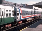 Image 14770 (202k, 1024x697) Photo by: Doug Grotjahn Collection of: Joe Testagrose Location: Polk |  Image 15004 (79k, 640x428) Photo by: David S. Cole Location: 54th/Cermak |  Image 15029 (108k, 640x411) Photo by: David S. Cole Location: Pulaski |  Image 33619 (165k, 720x478) Photo by: Peter Ehrlich Location: 54th/Cermak |  Image 84429 (264k, 1044x701) Photo by: David Pirmann Location: 54th/Cermak |
Photos By Location
Photo locations: Polk, 18th, Hoyne, Damen, Western, California, Kedzie, Central Park, Pulaski, Kostner, Cicero, Laramie, 54th/Cermak, 54th Avenue Yard
Page Credits
By David S. Cole