WMATA Red Line
![]()
WMATA Red Line station and train at Forest Glen. Photo by David Pirmann, August 2008.
Station By Station
Glenmont. We begin our journey on the Red Line at its eastern terminus at Glenmont. This underground station, just north of Wheaton, sits beneath Layhill Road, just north of Georgia Avenue. It features an island platform with Arch II architecture. The station lighting is different here: instead of the usual mercury-vapor lights in the crowns of the pylons, there are sodium lamps, which impart a reddish glow to the station.On the mezzanine, bright lamps with round shades are suspended by rods from the ceiling, a departure from the usual. The station is not as deep as those further down the line. Glenmont is the only suburban station terminal which is located underground. It also has a large parking lot and garage located at street level, with 1,781 parking spaces. Glenmont station opened July 25, 1998.
Wheaton. Wheaton station lies deep beneath Georgia Avenue, at Reedie Drive, just north of the town center. Its escalators are the longest in the system, in fact, they are the longest in the western hemisphere at 230 feet in length, they take just over four minutes to ascend. There are two individual tubes, with single side platforms (doors opening on the left), and Arch III architecture. A corridor links the two platforms in the center of the station. There is a small parking lot with 250 spaces nearby. A number of bus lines feed the station as well. Wheaton station opened September 22, 1990. (Wheaton, however, is not the deepest station in North America, that honor goes to Portland's Washington Park station.)
Forest Glen. Forest Glen station is architecturally similar to Wheaton but has one major difference. It is deeper still than its sister station, so deep, in fact, that an escalator link to the mezzanine could not be built. Instead, a bank of six elevators provides the only exit from the platform level. This is the only station in the Metro system to have an elevator-only exit. It is also the deepest station of them all, at 200 feet beneath the intersection of Georgia Avenue and Forest Glen Drive. There is also a parking facility here, with 596 spaces. Forest Glen station opened September 22, 1990.
Silver Spring: After Forest Glen, the Red Line comes out of its tunnel and emerges as a surface route, with the next stop at Silver Spring. This station was the Red Line's eastern terminus for several years. Some Red line trains still terminate here during the midday hours; these trains operate to Grosvenor. This station sits on a low elevated structure, adjacent to the MARC tracks over Colesville Road. It features a gull-wing roof design. The station entrances are on either side of Colesville Road. There are also layup tracks north of the station which are used by trains going to and from Grosvenor. A nearby parking garage provides 715 commuter parking spaces. Silver Spring station opened February 6, 1978.
Takoma. Takoma station is located near Blair Road NE and Cedar Street NE, which is almost at the District line. It is the first station within the District on the Red line. This station sits upon an embankment adjacent to the MARC tracks and is similar to Silver Spring, with a gull-wing roof. It also has a small commuter parking facility, with 146 short-term spaces available. Takoma station opened February 6, 1978.
Fort Totten (upper level). The Fort Totten station's upper level was constructed and opened long before the lower level. However, provisions for the lower level had already been built in. This station is located literally in the middle of Fort Totten Park, with access roads leading to it from Galloway Street NE and Gallatin Street NE. The level serving the Red line has an island platform and a gull-wing roof, similar to the Silver Spring and Takoma Stations. In the mezzanine are transfers leading to the lower level Green line platform. See the WMATA Green Line section for more information on the lower level station. South of this station, a single-track spur goes underground and connects with the Green Line at a point east of its station. In addition, there is a parking facility with 408 commuter spaces. Fort Totten station upper level opened February 6, 1978.
Brookland-CUA. The Brookland-CUA (Catholic University of America) station is located just south of Michigan Avenue NE near Bunker Hill Road NE. It is situated just below street level; Michigan Avenue NE passes over it via a street bridge. It is one of the few stations with a curved platform. This station also has an island platform with a gull-wing roof. It is located not far from the Shrine of the Immaculate Conception, whose golden dome can be clearly seen from the station. There is no commuter parking. Just further south the Red line goes into and out of a short tunnel as it switches from one side of the parallel CSX tracks to the other. Brookland-CUA station opened February 6, 1978.
Rhode Island Avenue-Brentwood. This station is the first of the original stations to be out-of-doors. It sits on an elevated structure over Rhode Island Avenue, east of 5th Street NE. Like its sister stations further up the Red line, it also has an island platform with a gull-wing roof. There is a slight difference, however in the size of the roof wings- they extend slightly further out, and the platform is wider. There is also a small parking lot with 340 spaces adjacent to the station. This station was the original Red line terminal when the system first opened. Just south, there is a train yard and maintenance/inspection facility, known as the Brentwood Service and Inspection Yard. The northbound tracks have a drop-off platform here for facility workers. Rhode Island Avenue station opened March 27, 1976.
WMATA commissioned a feasibility study for Metrorail's 84th station, New York Avenue in 1999, following requests by local residents and interest by the District of Columbia in revitalizing a part of its urban core. The agency completed preliminary engineering by the fall of 2000, and broke ground on December 16, 2000, after its design was approved by the National Capitol Planning Commission and the Commission of Fine Arts. Initial work included extensive site preparation and actual ground-breaking for the station itself occurred in November, 2002. WMATA expects 6,600 patrons to use this station within a year of its opening. Part of the rationale for its location was the presence of an urban zone where the DC government hopes to spur significant redevelopment. The final, full name of the station is New York Avenue-Florida Avenue-Galludet University.
The station opened on November 20, 2004. It was the first "in-fill" station on WMATA, built between the existing Rhode Island Avenue-Brentwood and Union Station stations. Station construction only had few major impacts on regularly scheduled service. The line had to be shut down from Fort Totten to Union Station for 5 weekends and single tracking was implemented many other times. The station is slightly west of the original right-of-way. The Shady Grove bound track is on a new elevated structure above the station mezzanine; the Glenmont bound track is in the former right of way for the Shady Grove track. The old Glenmont bound track may be abandoned entirely or it could be connected to the new Glenmont-bound track.
The station has an island platform and is the first station to have a Gull Wing II Style roof. The metallic canopy extends nearly the entire length of the platform and has skylights installed. The mezzanine is under the Shady Grove bound track and Metropolitan Branch bike trail and has exits at Florida Avenue and M Street. Station usage is expected to be light until the Bureau of Alcahol, Tobacco, and Firearms is completed in 2006 and other expected development in the area occurs although both fare controls are expected to remain open at all times. The station features two elevators from the platform to mezzanine so that a shuttle bus will not be needed when one is broken and 4 escalators and 4 staircases from the platform to mezzanine so that there should always be at least one escalator in each direction.
Union Station. Union Station is the next stop on the Red line. Just north of this stop, the line ducks underground once again, and remains there for quite a distance - all the way past Medical Center at the other end of the line. Union Station, also one of the original opening group, features two entrances - one directly in the station complex (at the west end of the concourse) and one near the corner of 1st and Massachusetts Avenue NE. This is a very busy station, with people going to and from the Amtrak and MARC terminals, plus shops and the stores in the Union Station complex. It wasn't always thus. When the station first opened in 1976, it was known as Union Station-Visitor Center. Leading up to the Bicentennial, groups tried to turn the main part of the station into The National Visitors Center, as a focal point for all tourists to find out anything about the nations capitol, It was a miserable failure; in the early 80's, it was closed because it was dangerous to walk through there due to large chunks of plaster falling from the ceiling, In the mid-1980s, it was completely restored, and dozens of small shops, stores and restaurants opened within its walls, in accordance with the original plan. The "visitor center" concept, as a result, was abandoned and the station name reverted to simply "Union Station". Now it ranks as a 'must-see' attraction in Washington. Union Station features an island platform and waffle architecture, with the ceiling being just a few feet lower than most, and the ceiling vault being slightly oval. There is only one entrance pod, at the south end of the station. The north exit leads directly out from the station's end. Union Station opened March 27, 1976.
Judiciary Square. After a reverse curve just south of Union Station, Judiciary Square is the next stop. This station is where Metro began, with ground being broken at 4th and E Streets NW. This is also the location of one of the two exits. The other one is at 5th and F Streets NW. This station sits on a diagonal between 5th and F and 4th and E Streets NW. It features waffle architecture and two side platforms. Just northwest of this station, the Red line turns sharply down G Street NW, continuing on its way. Judiciary Square opened March 27, 1976.
Gallery Place-Chinatown (upper level). Gallery Place-Chinatown's upper level is served by the Red line. This transfer point station is shaped like a sideways "T", with the WMATA Green Line and WMATA Yellow Line using the lower level tracks. The "Chinatown" designation was added in the late 1980s - the station was originally called "Gallery Place", for the National Portrait Gallery which is directly above. Entrances for the upper level are at 7th and G Streets NW and 9th and G Streets NW. This level has two side platforms and waffle architecture, similar to Metro Center, but the juncture of the two lines is at the far east end of the station. (An additional exit is at 7th and H Streets NW for the Green/Yellow line). This station had a delayed opening due to the fact that there was no handicapped access when the system originally opened. An assurance by WMATA that such access would be available in 1977 allowed the station to open shortly after the initial system opening. Gallery Place-Chinatown station upper level opened December 15, 1976. Artwork at south end of Gallery Place-Chinatown station: First American Bank's Metro Art I - "Yellow Line" Assemblage/Collage created by Constance Fleres.
Metro Center (upper level). Next, we arrive at the heart of the Metro system - the Metro Center Station. The Red line arrives on the upper level of this two-level transfer point station. Metro Center's upper level features two side platforms and waffle architecture. The WMATA Blue Line and WMATA Orange Line use the lower level, which crosses right in the center of the station beneath 12th and G Streets NW. At this point the ceilings of the two stations converge in a massive cross-vault which has to be seen in person to be fully appreciated. There are numerous entrances: 1) SE corner of 13th & G Street NW 2) NE corner of 12th & G Street NW; 3) SW corner of 12th & F Street NW, and 4) SE corner of 11th & G Street NW. There is also a Metro Information Center and gift shop at the south end of the station, near the 12th & F Street NW exit.
Metro Center station is by far the busiest in the system, with fast-moving crowds milling about in the rush hour. Watch your step and stay alert here - this is not for the squeamish or slow of foot. There are plenty of escalators in operation between the two levels, but those who stop to gaze at this massive station's beauty can be swept along by the herd of commuters. Best views are from the upper level, just outside of the Red line platforms. This station is a 'must-see' sight, not only for train and subway buffs, but for ordinary tourists as well. Metro Center station upper level opened March 27, 1976.
Farragut North. Farragut North station comes next - and is the busiest in the system; even more so than Metro Center in terms of fares. The station lies in the heart of the DC business district,and has two entrances - both under Connecticut Avenue NW, one at K Street NW, and the other at L Street NW. The station features an island platform with a modified waffle design. The ceiling vault is lower than normal, and at the north end the vault disappears altogether, replaced by an acoustic panel ceiling. There is also a single-track connection to the Orange/Blue lines just to the south, which is used to swap trains back and forth between the lines. Adjacent to the north (L Street NW) entrance is a large food court. Check out the beautiful acrylic painting of Farragut North station which is on display here. Farragut North station, opened March 27, 1976.
Dupont Circle. Dupont Circle station is one of the deepest in the system. It had to be built below a roadway underpass beneath Dupont Circle. There are two entrances, one in a plaza at Connecticut Avenue and Q Street NW, the other on the southwest face of the Circle, at Connecticut Avenue and 19th Street NW. The Q Street entrance has a rounded tube into which the escalators plunge. Locals refer to this as 'the bowl', as it looks like you are descending into one. The station itself features two side platforms with waffle architecture and a slightly raised vault. There is a track crossover just to the north, then the subway burrows deep into bedrock on its way northbound. If you watch from the front window, you will notice that the tunnel has both tracks side-by-side in a single wide tube for a distance. There is also a gentle bow curve, parallelling Connecticut Avenue itself. Dupont Circle station opened January 17, 1977.
Woodley Park-Zoo/Adams-Morgan. Woodley Park-Zoo station (as it was originally named) is the first station to employ the Arch design. This particular design, Arch I, is found primarily on this line. Three crossmembers divide the round ceiling and the long coffers rise from the base of the sidewalls. There is an island platform with the entrance pod in the station's center. This station is also one of the deepest (at 160 feet, the second-deepest,right after Forest Glen). The spectacular escalator takes over four minutes to ascend. The station entrance is located at 24th and Connecticut Avenue NW, with the elevator located one block north at Woodley Road. The Zoo itself is almost a half-mile walk north, so the station's name is somewhat misleading. It was originally intended to be "Zoological Park". The Calvert Bridge, with its numerous bus connections to Southeast DC is a short block east. The "Adams-Morgan" designation was added in 1999; the wall signs were replaced and the pylons have been relettered to reflect this change. Woodley Park-Zoo/Adams-Morgan station opened December 5, 1981.
Cleveland Park. The next stop is Cleveland Park, which is located beneath Connecticut Avenue NW, near Ordway Street NW. It is almost identical to Woodley Park-Zoo, except it is not quite as deep. There is an island platform with Arch I design. The entrance pod is in the center of the station. The neighborhood is less commercial here, with homes on the nearby side streets. It is also closer to the National Zoo than is the station at Woodley Park - by a distance of 106 feet. Visitors going to the Zoo may find getting off at this station easier, since Connecticut Avenue slopes toward the Zoo from here. Cleveland Park station opened December 5, 1981.
Van Ness-UDC. Van Ness-UDC station comes next. For a while, this was the western terminus of the Red line. Again, we see an island platform with Arch I station architecture. The entrance pod is at the north end of the station, leaving the balance of the platform open. The entrances themselves are on either side of Connecticut Avenue NW, between Van Ness and Veazey Streets NW. One of the campuses of DC University is right across the street. Right after the station, the subway takes a turn westward and downward, running in a deep tunnel beneath Yuma Street NW. Van Ness-UDC station opened December 5, 1981.
Tenleytown-AU. After a short, sharp curve, the Red line reaches upper Northwest at the Tenleytown-AU station. Originally called "Tenley Circle", the name was changed and the "AU" suffix added, referring to American University, which is a half-mile down Nebraska Avenue NW. This island-platform station also features the Arch I design. The station is located beneath Wisconsin Avenue NW, north of Tenley Circle, with entrances on either side at Albermarle Street NW. The main entrance and its pod is located in the center of the station. At the south end, an unusual sight can be found. The station elevator opens directly at platform level here, and standing guard before it is a single faregate (along with attendant bus transfer dispenser and Addfare machine); along with Takoma, probably the only stations with faregates located directly on the station platform itself. Cameras keep a watchful eye out for fare-beaters. Tenleytown-AU station opened August 25, 1984.
Friendship Heights. Friendship Heights station is next, and is located just at the District Line. This station has two entrances - one at Wisconsin and Western Avenues NW, the other at Wisconsin Avenue NW and Jenifer Street NW. Again, we find Arch I design with an island platform; there are entrance pods at either end of the station. The Western Ave. exit is unique; the escalators from the mezzanine empty into a large anteroom directly beneath the intersection of Wisconsin Ave. NW and Western Ave., with an exit for each corner of the intersection. Two of those exits are on the north side of Western and therefore, from a certain point of view, this is the first station in Maryland as well as the last station in the District of Columbia. The Jenifer Street exit has no escalators, only a bank of four elevators. This station is located in an area of many fine shops and stores - it is the rough equivalent of Rodeo Drive in the District of Columbia. Friendship Heights station opened August 25, 1984.
Bethesda. The first stop in Montgomery County, Maryland is at Bethesda. This station is located in the town center, at Wisconsin Avenue and Montgomery Lane, two blocks south of East-West Highway. This station also features Arch I architecture and an island platform. The station's entrance pod is just north of the center of the station. It is also somewhat deeper than its neighboring stops, but not as deep as others. It is frequented by commuters who not only work in the District, but who commute to Bethesda from the District and other parts of the county. Bethesda station opened August 25, 1984.
Medical Center. Medical Center station is located in a small plaza on the west side of Wisconsin Avenue, just above Jones Bridge Road. It was conceived as a station to serve the National Institutes of Health, and the National Naval Medical Center, for which it is named. It doesn't get too much traffic, as there is no commuter parking. Most of the people who use it work at the Center. There is the same island platform and Arch I ceiling that is found up and down the line. The entrance pod is just north of the station center. Medical Center station opened August 25, 1984.
Grosvenor. Just south of the Capital Beltway, the Red line tracks emerge from their tunnel, then leap over first Wisconsin Avenue then over the Capital Beltway itself on a high concrete trestle. There are two rolling curves, but the trains take them at cruising speed. The next stop: Grosvenor. Grosvenor station sits just outside the Beltway and below street level, in a shallow open cut. The terrain is hilly here. There is an island platform and a peaked roof design. The entrance is just east of Rockville Pike, between Montrose Avenue and Tuckerman Lane. Part of the entrance building is above the platform. Grosvenor station has a park-like setting, with attractive landscaping. Rockville Pike can be seen above and beyond the southbound tracks. There is a parking lot with 641 spaces. At the station's north end, the tracks dive into a tunnel cut into the hillside. During midday, trains from Silver Spring terminate here. Grosvenor station opened July 25, 1984.
North Bethesda (formerly named White Flint). After a stretch underground, the Red line emerges again at North Bethesda. This station, set in an open cut, is located east of Rockville Pike, at Marinelli Road. There is an entrance on the west side of Rockville Pike, with a pedestrian bridge over the roadway. The parking facility has 991 spaces. There are a number of major stores nearby, including the White Flint Mall. There is also a cluster of office buildings. There is an island platform, with a peaked roof design; the station entrance sits above the center of the station. North Bethesda (formerly White Flint) station opened December 15, 1984, and the new name took effect in September, 2022. (Photo captions have been updated to reflect the new name regardless of the date the photo was taken.)
Twinbrook. Twinbrook station follows another stretch of tunnel; it is situated on a low embankment east of Rockville Pike, on the south side of Halpine Road. This station's parking lot contains 1,098 spaces, hence it is geared mostly as a commuter station. There are offices and stores nearby. The station has an island platform with a gull-wing roof, and the entranceway is below platform level. There is also a bus island at the entrance. Twinbrook station opened December 15, 1984.
Rockville. At this point, the Metro tracks run parallel to the same CSX railroad line as is at its other end in Silver Spring. Rockville station is next. It is situated on an elevated structure, just east of Rockville Pike. The entrance is off Hungerford Drive, near the intersection of Park Avenue, right in the center of town. There is a fair amount of reverse-commuting from the District and lower Montgomery County - a number of large companies have offices here. The parking lot contains just 524 spaces, with an additional 121 metered spots; numerous bus lines connect here. The station features an island platform and a wide gull-wing roof. Rockville station opened December 15, 1984.
Shady Grove. Shady Grove station marks the western terminus of the Red line. This station sits on a low embankment, east of Rockville Pike with entrances at Shady Grove Road and Redland Road. The extra-large parking lot and garage contains 4,261 spaces and is very popular with commuters. A number of bus routes also terminate here. There is an island platform and modified gull-wing platform roof. Just to the north, there is a layup yard, and a maintenance/inspection facility. There is a short spur intended as a provision for future extension. Shady Grove station opened December 15, 1984.
Photo Gallery
| Five Random Images | ||||
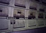 Image 21076 (83k, 744x496) Photo by: Wayne Whitehorne Location: Judiciary Square |  Image 21151 (75k, 740x497) Photo by: Wayne Whitehorne Location: Shady Grove |  Image 65035 (326k, 1044x705) Photo by: S.L. Peters Location: Brentwood Yard |  Image 89996 (222k, 1044x701) Photo by: David Pirmann Location: Farragut North |  Image 90076 (264k, 1044x701) Photo by: David Pirmann Location: Gallery Place-Chinatown |
Photos By Location
Photo locations: Glenmont, Wheaton, Forest Glen, Silver Spring, Takoma, Fort Totten, Brookland-CUA, Rhode Island Avenue, Brentwood Yard, NoMa-Gallaudet University (New York Avenue), Union Station, Judiciary Square, Gallery Place-Chinatown, Metro Center, Farragut North, Dupont Circle, Woodley Park-Zoo/Adams-Morgan, Cleveland Park, Van Ness-UDC, Tenleytown-AU, Friendship Heights, Bethesda, Medical Center, Grosvenor-Strathmore, North Bethesda (White Flint), Twinbrook, Rockville, Shady Grove
Page Credits
By Wayne Whitehorne.
| ||||||||||||||||||||||