WMATA Blue Line
![]()
WMATA Blue Line train with car #3082 trailing inbound at Van Dorn Street. Photo by David Pirmann, January 2012.
Overview
In October 1999, Congress approved design funding for the extension of the Metro Blue Line between its former terminus at Addison Road to Largo Town Center, with an additional station to be constructed at Morgan Blvd. This represented the first extension of Metro past its original planned boundaries, as well as the first Metrorail line to extend beyond the Capitol Beltway in Prince George's County, and will bring Metrorail's total route miles to 106.1. The project was planned as a 3.1 mile long surface route, with a couple of flyover/elevated segments tossed in.
The total cost of the extension was pegged at $456 million, of which $92.8 million paid for stations and "Park 'N Ride" facilities. The two new stations have 30-foot wide platforms (two feet wider than existing stations), bus bays and "Kiss 'N Ride" lanes. Largo Town Center's parking lots holds to 2,100 automobiles.
On February 4, 2000, the US Department of Transportation confirmed $259 million in federal funds for the project; the State of Maryland had already committed $175 million. In May 2001, WMATA broke ground on the extension; by April 29, 2002, a bridge was being erected over the Capitol Beltway.
Station By Station
Downtown Largo (formerly named Largo Town Center) opened on December 18, 2004. Largo is the first station outside the beltway in Prince Georges County (the Orange Line at New Carrollton and both ends of the Green Line stop just short of the Beltway). The Downtown Largo station is located near the intersection of Lottsford Road and Harry S. Truman Drives, right next to the Boulevard at Capital Centre (the site of the USAirways Arena). The elevated station has an island platform with a Gull Wing II style roof covering about half the platform. There are 2 elevators and 3 escalators and staircases going down to the mezzanine. On both sides of the station are the parking structures. There are no station name pylons on the platform. The north side of the station has several bus bays at the same level as the mezzanine and the south side has a surface lot and a kiss and ride at a level between that of the trains and mezzanine; there is an incline to the south of the station. There is also a stainless steel and laminated holographic glass beacon in front of the south mezzanine entitled "Largo Beacon." The new name took effect in September, 2022. (Photo captions have been updated to reflect the new name regardless of the date the photo was taken.)
The tracks continue east of the station and into a tunnel that is used for storage of trains off hours and has a small service area, the first underground one on the Metro. This eliminates the need for storing Blue Line trains at New Carrollton during the middays.
As we leave Downtown Largo, we go onto a bridge that is named for Decatur Trotter, a WMATA Board member and Maryland State Senator. The bridge takes us over the Capital Beltway and almost immediately descend into a shallow cut and cover tunnel. The residents in the area of the new line wanted minimal noise and disruption from the train, so WMATA built most of the extension in a very shallow cut and cover, about 12 feet underground. In some places, the train was essentially built at the level of the surface, but the tracks were built with walls around them and earth was piled on top of the "tunnel." The extension includes a total of 1,700 feet of double-track at grade and 10,500 feet of covered route.
The Morgan Bouelvard station bears similarities to the Southern Avenue and Branch Avenue stations on the southern end of the Green Line, although it is one of the more unique stations in the Metrorail system. The station is in a shallow cut, like the aforementioned stations. The station is located near the intersection of Morgan Boulevard and Central Avenue and is within walking distance of FedEx Field, where the Washington Redskins play. There is an island platform, wider than that at most stations due to the expected high volumes for events at FedEx Field. The mezzanine itself has a Gull Wing II style roof and forms the roof over the platform. There are 2 elevators and multiple escalator/stair banks between the mezzanine and platform. The station has a surface parking lot and a daycare center so that parents can drop off their kids as they catch the train downtown. There is also a sculpture paying tribute to Garrett Morgan, the inventor of the stop and go traffic light, in between the parking area and station enterance. The station was originally to be called Summerfield but was changed to reflect the change in name of Summerfield Boulevard to Morgan Boulevard. Morgan Boulevard station opened on December 18, 2004.
After leaving Morgan Bouelvard, the train continues in a tunnel for a short distance, then comes out onto a bridge in which the tracks are fenced in, then back into a tunnel until shortly before reaching Addison Road, the former end of the line. In the span of approximately a quarter of a mile, the line will come out of the tunnel and run on the surface, then onto a very short elevated section, make the Addison Road station stop which is partially elevated and partially surface, and then enter the subway again.
Addison Road. This station is just east of the District line, at ground level on the south side of Central Avenue and east of Addison Road. It has an island platform with a peaked roof design. At the west end of the station, the tracks go immediately underground. Commuter parking is available, with 1,268 spaces in the lot. Addison Road station opened November 22, 1980.
Capitol Heights. Capitol Heights station is located right at the District line, at Southern Avenue and East Capitol Street in Capitol Heights, Maryland.. This station has waffle architecture and an island platform, which is the most common configuration. The entrance pod is at the west end of the station. There is a small parking facility nearby, with 373 parking spaces. East of the station, the tracks curve gently, following the alignment of Central Avenue. Capitol Heights station opened November 22, 1980.
Benning Road. The Benning Road station is almost identical to the Capitol Heights in terms of appearance - waffle architecture and island platform. The station is located beneath Benning Road NE with an entrance just north of East Capitol Street. The entrance pod is at the far east end of the station, and there is a sudden curve just after the station's end. Benning Road station opened November 22, 1980.
About a mile past Benning Road, the Blue line emerges from its tunnel and climbs onto an elevated structure, where it joins the Orange Line branch from New Carrollton. (See the WMATA Orange Line section for a tour of these stations.) The elevated runs along Benning Road, then it swings southwest, cutting through the parking lot of RFK Stadium before diving underground once again. From this point to Rosslyn Station in Virginia, the Blue and Orange Lines share the same track and stations.
Stadium-Armory. At this point, the Blue (and Orange) lines are underground. The first of these underground stations is Stadium-Armory. This station sits beneath 19th Street SE, with two entrances: one at Independence Avenue SE and another between Burke and C Streets SE. It features a slightly higher ceiling vault and waffle architecture, with an island platform. There is an entrance pod at each end, with the center of the platform remaining open. A sign at the north end of the station informs passengers as to the arriving train's destination, showing blue for Addison Road, and orange for New Carrollton. This is the final transfer point between the Blue and Orange lines. DC General Hospital is nearby, as well as the City Jail, RFK Stadium and the National Armory. Stadium-Armory station opened July 1, 1977.
Potomac Avenue. Potomac Avenue station's entrance sits in a little park at the intersection of 14th and G Streets SE. The subway actually runs for a few blocks beneath G Street SE itself, turning off of Potomac Avenue SE, then onto Pennsylvania Avenue SE. This station features the most typical design features - waffle architecture, ceiling of average height and an island platform. The entrance pod is roughly in the center of the station. There are sharp curves in the tunnels just outside both ends of the station, with the one at the west end being particulary severe. This is one of the few places in the system where wheel noise is clearly evident. Potomac Avenue station opened July 1, 1977.
Eastern Market. The next station is Eastern Market, which is located at Pennsylvania Avenue SE, between 7th and 8th Streets SE. In the original Metro plans, this station was to be called "Marine Barracks", after the nearby facility of the same name. It is architecturally identical to Potomac Avenue, with waffle design and island platform. Again, the entrance pod is in the station's center. Eastern Market is slightly less deep beneath the surface than Potomac Avenue. A number of local bus lines run along 8th Street SE, and there is considerable transfer traffic between the buses and the subway here. Nearby, along 7th Street SE, is the Eastern Market itself, notable in the District for its gourmet food available to the public at wholesale prices. Eastern Market station opened July 1, 1977.
Capitol South. The subway turns off Pennsylvania Avenue and down North Carolina Avenue SE for two blocks before running beneath D Street SE. Capitol South station is next, and is a popular stop with tourists as it is the closest in proximity to the U.S. Capitol itself. With an entrance located at the northwest corner of 1st and D Streets SE, this waffle-style, island platform station is close to many big attractions: the Capitol, the Library of Congress and the Supreme Court building. However, there is a walk up a steep hill to get to these locations. There is a single entrance pod near the station's east end. It also attracts folks who work in the various House and Senate office buildings nearby. Capitol South station opened July 1, 1977.
Federal Center SW. Federal Center SW station, whose entrance is at the southwest corner of 3rd and D Streets SW, is similar to Capitol South in terms of layout and architecture, with waffle design and an island platform. It isn't close to too many big attractions, although the Space Museum, the Botanical Garden and a wax museum are all within walking distance. The entrance pod is near the center of the station. Just to the west, the subway makes a slight wobble as it realigns itself beneath D Street SW. Federal Center SW station opened July 1, 1977.
L'Enfant Plaza (lower level). The L'Enfant Plaza station's lower level is noteworthy because it is the only case where a transfer station's lower level opened before its upper (or main) level. The entire station resembles Metro Center somewhat, in terms of overall design, with a massive intersecting vault in the center. However, the upper level's pod entirely covers the lower level, so all that is visible are the station's side walls, which are of waffle design. The ceiling of this level is rather low and the light is somewhat dim. The Blue and Orange lines arrive at an island platform. Upstairs, the WMATA Green Line and WMATA Yellow Line hold court. The pylons outside this station are distinctive - they carry four of the five system colors on them. There are four entrances: 1) the southeast corner of 9th & D Streets SW, 2) inside the L'Enfant Plaza Shopping Concourse 3) on the south side of D Street SW between 6th & 7th Streets SW 4) the southeast corner of Maryland Avenue SW & 7th Street SW. This entrance is the closest in proximity to the Air & Space Museum. The physical center of the station is beneath 7th and D Streets SW. This area is full of hotels, and is convenient for travelers. Airport access is fast - via the Yellow Line on the upper level. It can get almost as busy as Metro Center in the rush hour, with people changing lines and trains. Best views of the station are from the upper level - see the WMATA Green Line section for full details. L'Enfant Plaza lower level opened July 1, 1977.
Smithsonian. The Blue and Orange lines take a northward turn just about at 11th Street SW. Smithsonian station is next, with two entrances: one at Independence Avenue and 12th Street SW, the other, smack on the Mall, west of the Smithsonian's Castle building. The station is located parallel to 12th Street SW and the freeway tunnel entrance north of Independence Avenue SW. It features waffle architecture, along with two side platforms. Entrance pods are at either end of the station. Next to the Farecard machines at the north entrance you can catch a picture of a train zooming into the station from above. This station gets very crowded at times, with most of the traffic being tourists. The new Holocaust Memorial is near the south station entrance. It is also within walking distance of the other Mall attractions, such as the Museum of Natural History/ Museum of Man, the Museum of History and Technology, and the Washington Monument. Smithsonian station opened July 1, 1977.
Federal Triangle. Cleverly concealed in an office building courtyard on the west side of 12th Street NW is the entrance to the Federal Triangle station. If the pylon at curbside was not there, one might never find the station entrance. This station, with its island platform and waffle architecture is located between Pennsylvania and Constitution Avenues NW, in a triangular cluster, easily seen on maps, of federal office buildings, hence its name "Federal Triangle". The IRS Building is right around the corner. Across 12th Street NW from the entrance is "The Old Post Office", a unique cluster of shops, restaurants and such; you can take a ride up the tower elevator to get a spectacular view of the Mall area. The entrance pod is just south of the station center. It can get pretty crowded here, especially at peak hours. Federal Triangle station opened July 1, 1977.
Metro Center (lower level). Next, we arrive at Metro Center's lower level platform. The connection to the WMATA Red Line is upstairs. There is a low ceiling, similar to that at L'Enfant Plaza, and only the station's waffle sidewalls are visible, due to the upper level's pod covering the entire length of the platform. Lighting here is better than at L'Enfant Plaza. Sometimes, trains are held briefly in order to connect with Red line trains arriving above. Congestion is common here; and sometime train traffic backs up. Just north, the tracks take a sharp, 90-degree turn from 12th Street NW into Eye Street NW. Metro Center station lower level opened July 1, 1977.
McPherson Square. McPherson Square station is the closest in proximity to the White House, and, accordingly, gets a large amount of tourist traffic. This station features two side platforms and the usual waffle architecture. There are two entrances - one at 14th and Eye Streets NW, the other at Vermont Avenue NW and Eye Street NW, the latter being the one serving White House tourists. The Square itself sits between the two entrances, and features a statue of the General himself. It is a lunchtime rest stop for the area's work force. Oddly enough, the suffix "White House" has never been added to the station's name, even though it is right nearby. McPherson Square station opened July 1, 1977.
Farragut West. The Farragut West station comes next. Just before it, a single track branches off to connect with the Red line, allowing trains to be swapped back and forth. At first glance, this station looks no different than McPherson Square, with its two side platforms and waffle architecture, but look closer - there are no platform pylons. The route strip maps are found on large plaques mounted right on the wall. This change was instituted after the station was opened. Farragut West is extremely busy at rush hours; there is a large number of office buildings in the area. There are two entrances, one at 17th and Eye Streets NW, the other one block west at 18th Street. There is an entrance pod over each end of the station, just like at McPherson Square. Farragut West station opened July 1, 1977.
Foggy Bottom-GWU. After a left-right reverse curve, Foggy Bottom-GWU (George Washington University) is next. This station is located at 23rd and Eye Streets NW, and features an island platform with a slightly oval waffle ceiling. The entrance pod just west of the station center. Towards the far west end is the handicapped-access elevator. The station is among the darkest in the system, with many of the sidewall lights out, and the ceiling grimed and greyed by track dust. This is about as close to Georgetown as the Metro gets, which is a distance of about half a mile. The Kennedy Center and the Watergate Hotel are local attractions. This is the last stop in the District; the subway descends into a long tunnel beneath the Potomac River before reaching the Virginia side. Foggy Bottom-GWU station opened July 1, 1977.
Rosslyn. The first stop in Virginia is Rosslyn, which is located deep beneath North Lynn Street, with entrances between 19th Street South and North Moore Street, and and on Fort Myer Drive, one block east. This bi-level station has an interesting feature - one platform is higher than the other. This is because the WMATA Orange Line tracks diverge just after the station, and the tracks are at different levels to avoid crossing at grade. Although it appears to be a side-platform configuration, it really is a bi-level island platform. The outbound side platform is lower than the inbound side by almost twenty feet. Escalators link the two levels. The station features waffle architecture, but on the outbound side, the vault of the ceiling is breathtakingly high, almost sixty feet. The entrance leads into the west wall of the station, and there is a short walkway over the outbound tracks leading to it. It can get quite busy here, with people transferring from Blue to Orange line and vice versa. There are also a large number of office blocks in the immediate vicinity. At the south end of the station on the outbound side, blue and orange signs announce which train is arriving. Rosslyn station opened July 1, 1977.
Arlington Cemetery. Arlington Cemetery station is unusual in the fact that it is the only station that closes before the rest of the system does. Literally in the middle of nowhere, this station's sole purpose is to serve visitors to the Cemetery and Tomb of the Unknown Soldier. Still, it is a long walk from the station to the cemetery. Weeknights, it closes at 10 PM, weekends (and during the winter) at 7 PM. It sits at ground level near Memorial Drive and features two side platforms with a modified gull-wing roof design. There is a nice view of the city from the train as you pass south of the station, heading towards Pentagon. Arlington Cemetery station opened July 1, 1977.
Pentagon. The surface line dives underground once again, then makes a sharp right turn. Next is Pentagon, appropriately named - it sits beneath the southeast face of the Defense Department headquarters building. This is a sister station to Rosslyn - with a bi-level island platform. Again, the station has waffle architecture with a 60-foot-high vault over the outbound platform. The WMATA Yellow Line joins here, after crossing its Potomac River bridge. Like at Rosslyn, there is a footbridge over the outbound tracks leading to the entrance, which is located near the bus island adjacent to the Pentagon building. There is also an entrance an the underground shopping plaza, which is only open to Pentagon employees who have security clearance. At the north end of the inbound platform, blue and yellow signs announce the arriving train's destination. Just south of the station, you can see a bellmouth in the tunnel showing where a spur might lead - there was once talk of a Metro line running along Columbia Pike in southern Arlington to a terminal at Lincolnia. Nothing ever came of this proposal, but the provision for the spur is there nonetheless. Pentagon station opened July 1, 1977.
Pentagon City. The Pentagon City station is located on the east side of South Hayes Street, near the corner of 15th Street South in the Virginia Highlands neighborhood. There is a complex of buildings there by that name, and a newer, larger retail complex called Pentagon Center has recently opened, featuring Nordstrom's, Macy's, Costco as well as numerous other small stores and restaurants; this has increased the station usage rather dramatically. It features two side platforms and waffle architecture and is similar to the nearby Crystal City station. The entrance pod is just to the west of the station's center, and platform pylons make their return. Pentagon City station opened July 1, 1977.
Crystal City. This station's main entrance sits in front of an office building on the north side of 18th Street South, near South Clark Street. (1755 Crystal Square South, to be exact). It sets back from the street and would be hard to spot if not for the pylon at curbside announcing it. The station is located under 18th Street South (extended) between South Clark Place and Jefferson Davis Highway (US Route 1) Large hotels are near here, including representatives of the major national chains. Business travelers, office workers, tourists and shoppers use this station, and it can get very crowded at any time of the day or evening. There are two shopping centers located just below street level, with direct station access - the Crystal Underground, with its eclectic shops and eateries, and the Crystal Plaza, with tonier stores. A tunnel also leads from the Crystal Underground directly to the Marriott Crystal Gateway, an enormous hotel. Since the airport is just one stop away, this place is popular with visitors. There are two side platforms, with pylons, and waffle architecture. The entrance pod is in the station's center, and the escalators are shorter than most. Crystal City station opened July 1, 1977.
National Airport. National Airport station is one of only two in the system to have three tracks (the other is West Falls Church). It sits directly in front of the Ronald Reagan National Airport terminals, connected to the station by two recently-constructed bridges over the airport terminal roads. The two island platforms have gull-wing roofs, which nearly touch each other over the center track. This track used to be where the Blue and Yellow line trains turned around before their southern terminals were opened. It is rarely used now; occasionally a Blue line train will terminate here. This station sits upon an elevated structure, about thirty feet above the street below. Thick, round, concrete piers support the station and trackways. The station's entrance is just to the south of the station center. It can get hectic here, with travelers and tourists coming and going, many carrying luggage with them. There are station porters ready to assist. Also, the station corridors and ramps are extra wide, to prevent congestion. With the renovation and the expansion of the North Terminal, there is now direct access to the Airport from the station via a pedestrian bridge, ridership has exceeded expectations with this enhancement. To the south, the third track splits and merges back with the other two, and there is a broad S-curve, with the trackways descending from elevated to ground level. National Airport station opened July 1, 1977.
Potomac Yard-VT. Until 2023, the Blue and Yellow line trains traveled a long stretch between the Airport and Braddock Road, with no intermediate station, alongside an old RF&P railroad yard. Proposed starting in the 1990s, a redvelopment plan for the yard, with Virginia Tech (the "VT" of the station name) a main tenant, included a new station. Construction is similar to new stations on the Silver Line, exposed steel with an arched roof, and some stone facing. Extensive elevated walkways are needed to access the Potomac Ave./Potomac Yard Trail entrances to the station. As a "transit-oriented development", the station is served by buses but does not have any parking. Three railroad tracks carrying CSX, Amtrak, and Virginia Railway Express trains are adjacent to the station. From the platform one can see the passing freight and commuter trains, the Potomac River, the Washington Monument, the Capitol dome, and the city of Alexandria. Potomac Yard station opened 5/19/2023.
Braddock Road. Braddock Road station is the first stop in Alexandria, VA. Its entrance is just above Braddock Road, on the west side of West Street. The station sits on an embankment and features a wide peaked roof with an island platform. Alexandria buses connect with the Metro at a drop-off island. The Braddock Place office plaza is adjacent, with a number of number of large buildings. An interesting sight is just north of the station, visible from passing trains - the "Association of Old Crows". Braddock Road station opened December 17, 1983.
King Street. King Street station serves downtown Alexandria, and is the last transfer point to the WMATA Yellow Line, which branches off to Huntington just to the south. It is architecturally similar to Braddock Road, with an island platform and wide peaked roof. It also sits on the same type of embankment, but is a little lower than its sister station. Blue and yellow signs at the south end of the outbound side announce the arriving trains' destinations. The Alexandria Amtrak station is adjacent, with Virginia Rail Express service also provided. The George Washington Masonic Memorial's tall column is clearly visible right nearby. King Street station opened December 17, 1983.
Van Dorn Street. The Van Dorn Street station is a considerable distance from King Street. Here, the Metro tracks run parallel to the CSX railroad. Between here and King Street, the Metro car overhaul facility can be seen on the south side of the tracks. Van Dorn Street is at ground level, with an island platform and a gull-wing roof. The entrance is near the intersection of South Van Dorn and Vine Streets. There is a mid-size parking facility nearby, with 361 spaces. This was the terminus of the Blue line between 1991 and 1996. Van Dorn Street opened June 15, 1991.
Franconia-Springfield. Franconia-Springfield station is the current Blue line terminus. It sits alongside the CSX tracks, about a mile south of Franconia Road. Primarily a commuter station, it has a large parking garage and a number of parking lots. The building housing the mezzanine and station entrance sits above the island platform. It is supported by tall square columns, and the sides are open. The mezzanine is long and wide, and there is an enclosed walkway leading from the station entrance to the parking facilities. A commuter's dream, there are a total of 3,856 parking spaces here, plus numerous bus connections. Franconia-Springfield station opened June 28, 1997.
Photo Gallery
| Five Random Images | ||||
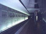 Image 21089 (57k, 737x494) Photo by: Wayne Whitehorne Location: L'Enfant Plaza |  Image 36510 (99k, 820x620) Photo by: Chris Coles Location: Downtown Largo (Largo Town Center) | 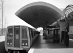 Image 42630 (119k, 815x539) Photo by: S.L. Peters Location: Van Dorn Street | 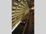 Image 101546 (259k, 701x1044) Photo by: David Pirmann Location: Rosslyn | 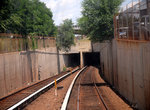 Image 102026 (309k, 1044x705) Photo by: S.L. Peters Location: Braddock Road |
Photos By Location
Photo locations: Downtown Largo (Largo Town Center), Morgan Boulevard, Addison Road/Seat Pleasant, Capitol Heights, Benning Road, D&G Junction (Blue-Orange), Stadium Portal (Blue-Orange), Stadium-Armory, Potomac Avenue, Eastern Market, Capitol South, Federal Center SW, L'Enfant Plaza, Smithsonian, Federal Triangle, Metro Center, McPherson Square, Farragut West, Foggy Bottom-GWU, Rosslyn, Arlington Cemetery, Pentagon, Pentagon City, Crystal City, Ronald Reagan Washington National Airport, Potomac Yard, Braddock Road, King Street-Old Town, Alexandria Yard, Van Dorn Street, Franconia-Springfield
Page Credits
By Wayne Whitehorne.
| ||||||||||||||||||||||