Lyon, France Trams
![]()
Citadis Low-Floor Type 302 no. 0810 on Line T1 at IUT-Feyssine. Photo by Bernard Chatreau, January 2001.

Overview
The city of Lyon, France, initiated two new tramway lines on January 2, 2001. The new lines complement Lyon's métro system (4 lines, 46 stations), and have been perceived as a cheaper way to complete the métro system's plans. Lyon is the second largest city in France and the new tram lines have achieved 45,000 riders a day on line T1 and 42,000 riders a day on line T2, more than expected (original estimates were 65,000 riders a day in the first year, for T1 and T2 combined). The tramway lines have been constructed using a variety of methods, including segregated street running and some private right of way. Line T1 follows the curve of the River Rhône and its many curves lead to a lower average speed than found on line T2.
Station By Station
Line T1 - Perrache to IUT-Feyssine
Line T1 is approximatively oriented from Lyon downtown to the northeast and is 8.7 km in length.
Lines T1 and T2 begin in an old street tunnel under the SNCF (Société Nationale des Chemins de fer Français, French National Railways) tracks at Lyon-Perrache station, one of the two main stations in Lyon. Two tracks share this tunnel with pedestrians. The tracks are used bi-directionally to reverse the double-ended streetcars. A third reversing track has been laid in front of the Perrache railway station. The modern concrete building above is the Centre d'Echanges (Transfer Center), at which many bus and trolleybus lines terminate. On the ground level is the tram terminus, and alongside is the terminus of Métro line A. The Perrache stop provides transfer to Métro line A and SNCF lines at the Lyon-Perrache railway station.
Departing Perrache, the tram tracks are laid on the north side of Cours de Verdun. The lines cross the River Rhône on the Gallieni Bridge, then lines T1 and T2 diverge: tracks straight ahead are those of line T2 on Avenue Berthelot, and tracks which turn left on Quai Claude Bernard are those of T1.
Line T1 is on the east side of Quai Claude Bernard, northbound along the Rhône. Quai Claude Bernard stop is close to a new hospital (constructed around the same time as the tram). Next, tramway T1 passes in front of the old Lyon universities (Université Lumière, then Université Jean Moulin) and then turn right onto the north side of rue de l'Université to reach Rue de l'Université stop.
Departing Rue de l'Université, there is another right angle turn to head northbound on the east side of Rue de Marseille, a narrow and busy street. There are two stops along this stretch: Saint André and Guillotière, the latter of which providing transfer to Métro line D. The line continues on the west side of Cours de la Liberté, where trees have been preserved when the line was built. A bit further north is the Liberté stop.
Another right angle curve and the line heads eastbound on the south side of Rue Servient. The building seen in background is a landmark of the Part-Dieu neighborhood of Lyon nicknamed "le crayon" ("the pencil", in English, photo below). The next stop is Saxe-Préfecture, allowing transfer to Métro line B. Then, the T1 tram crosses one of Lyon's trolleybus lines. There are two more stops along Rue Servient, Moncey-Mairie du 3ème (also permitting transfer to Métro line B) and Part-Dieu-Servient.
In the Part-Dieu section of Lyon is a large shopping center and the second main railway station, built shortly after the beginning of TGV service between Paris and Lyon in the early 1980s. Tramway T1 uses a road underpass to cross under the shopping center. The line turns left (northbound) to arrive at one of the most important stops on the line: Part-Dieu Vivier-Merle. This station is the terminus of several bus lines, and provides transfer to Métro line B and the railway station. There are two stub-end tracks for partial service between Part-Dieu and IUT-Feyssine.
The line now turns right onto the north side of Cours Lafayette. This section is shared one-way with a trolleybus route. The tramway line dips under a bridge carring the SNCF tracks from Part-Dieu station. Then, a left turn onto the northbound side of Avenue Thiers. There are two stops along this stretch: Thiers-Lafayette and Collège Bellecombe.
The T1 tram now turns right on Rue des Emeraudes. Here the line leaves Lyon and enters Villeurbanne. After crossing a square, there is a stop at Charpennes-Charles Hernu. This is an important transfer point with Métro lines A and B. Many students from the university campus at La Doua (located at the end of the tram line) use this stop to transfer to the métro lines. The line continues on streets mainly used by the tram through residential areas, with a stop at Le Tonkin. Crossing the Place Jean Chorel, the T1 tram runs on Rue Mozart, then turns left on Avenue Condorcet. This stretch of line is a a private central reservation, including the Condorcet stop.
The T1 tram now enters the final stretch of its route, crossing the Boulevard du 11 Novembre. The line enters the La Doua campus, with the tracks running in a private, grassy right of way (but be careful, there's concrete under the grass). There is a sharp right curve to the first campus stop at Université Lyon 1, then the main campus stop at La Doua-Gaston Berger.
The line now passes a factory, the last remnant of Lyon's industrial past, into an area now dedicated to universities, and arrives at INSA-Einstein stop. From here, there are grassy tracks on Avenue Albert Einstein, then another curve to the terminus at IUT-Feyssine. Just past the station there are two stub-end reversing and storage tracks.
On September 5, 2005, a three-station extension down the peninsula between Perrache and Montrochet was opened--running nearly to the confluence of the Rhône and Saône Rivers. This is a gentrifying district and the terminal station, Montrochet, lies in the vicinity of recently-demolished "batiments". The three stations are Suchet, hard by the southerly entrance to Gare Perrache; Ste.-Blandine, and Montrochet.
Line T2 - Perrache to Porte des Alpes
Line T2 is oriented from Lyon downtown at Perrache to the southeast. See above for description of the T2 terminus at Perrache.
Diverging from the T1 at Quai Claude Bernard, the T2 tramway line enters the straight Avenue Berthelot, on a private right of way on the north side of the avenue. This avenue was previously flooded with traffic, but the tram has reduced the space devoted to cars (it is now two lanes only). The car traffic has been divided in two and Avenue Berthelot is now more pedestrian-friendly. Trees have been planted in several places along the sidewalks. The first stop is at Centre Berthelot. The next stop along Avenue Berthelot is at Jean Macé, which provides transfer to Métro line B and several bus and trolleybus lines. The SNCF tracks from Perrache are along the south side of the avenue. Following are two more stops at Garibaldi-Berthelot and Route de Vienne.
On the south side is a cemetary (Cimetière de la Guillotière) and along the north side of the avenue, many old little buildings in this previously derelict area have been or will be demolished. Real estate programs are quickly changing the appearance of this neighbourhood, with the tramway being quite welcome (there is even a café named Le Tram). Stops along Avenue Berthelot in this area are at Jet d'eau Mendès-France, Villon and Bachut-Mairie du 8ème. The line then turns left onto Boulevard Jean XXIII in a central reserved right of way into a lower-density area, stopping at Jean XXIII-Maryse Bastié. Then, approching the Grange-Blanche stop, there is a central reversing track.
Grange-Blanche is an important transfer stop to Métro line D. The line turns onto Avenue Rockefeller, on a grassy right-of-way along the south side and climbs a soft grade to Ambroise Paré stop, which has been built on land taken from a park. Still on Avenue Rockefeller, on the central right of way, the line continues to climb to Vinatier stop, at the summit of the hill near a reservoir.
The tram now leaves Lyon proper and enters Bron along Avenue Franklin Roosevelt. The line is built on land taken from the Vinatier Hospital, on the north side of the avenue. There are two grassy tracks and a bicycle lane under the trees. A stop is made at Essarts-Iris. The line crosses the inbound lanes of Avenue Franklin Roosevelt, onto a central private right-of-way, passes under the Boulevard Laurent-Bonneway (a circular freeway around eastern Lyon), and arrives at Boutasse-Camille Rousset stop. Nearby is another shop named for the tram, le libre-service du tramway ("Tramway Self-Service"), and a real estate advertisement featuring the tramway.
The tram now enters downtown Bron and stops at Hôtel de Ville-Bron (Bron City Hall), then continues on Avenue Franklin Roosevelt to Les Alizés stop. The line turns right southbound on Rue du 8 Mai 1945, on a central private right of way. A stop is made at Rebufer.
The line then passes under a freeway bridge and runs down Avenue de l'Université to Parilly-Université stop. From here, the tram enters the university campus and stops at Europe-Université. After a short underpass, the line runs in on private right-of-way nearby a shopping center and approaches the Centre de Maintenance (depot and shops). The final stop is at Porte des Alpes. The line will be soon extended to Saint-Priest.
The depot near Porte des Alpes provides for the storage and maintenance for the trams of both T1 and T2 tram lines. Also, after the opening festivities in January 2001, some museum trams were temporarily stored in the depot.
In late 2005 or early 2006, Line T2 opened a new 10-station extension from Porte des Alpes. This pushed the line further eastward into the town of St.-Priest, with a new terminal at St.-Priest Bel Air.
Line T3 - Part-Dieu to Z.I. Meyzieu
Lyon's third tram line, the 14.6km T3, has characteristics completely different from the first two routes. The route took over a SNCF commuter rail/freight spur branch, and there are numerous grade crossings all across the largely industrial, but redeveolping, route. This line opened on December 4, 2006, and is isolated from the rest of the tramway network, although a track connection could be built north from the Part-Dieu Villiers inner terminal to a junction at Cours Lafayette with the T1. The dozen or so Citadis trams assigned to the Meyzieu depot are geared for faster operation to match the open, private-right-of-way characteristics of the new line.
The line begins at Part-Dieu Villiers, which lies on the east side of Gare Part-Dieu. A 100-meter long turnback track lies north of the station. There are two side platforms here, as at most other stations. After leaving Part-Dieu Villiers, the line makes a broad curve eastward and takes over the old railroad right-of-way through a semi-industrial district, stopping at Dauphiné Lacassagne. The next station, Reconnaisance Balzac, is situated in a residential area, and the tracks have to cross busy Route de Genas to reach the station. Next up is Gare de Villeurbanne, where the original station building still stands. Now the line gets fast, running through light and heavy industry for much of the route. Next eastward station is Bel Air Les Brosses, followed by Vaulx-En-Velin La Soie, where a transfer station to Métro Line A will open later in 2007. The next station, Décines Centre, is decidedly residential, but up the line, industry takes over at Décines Grand Large, notable for a 4-track facility with two center tracks set up for express (or maybe freight) operations. Meyzieu Gare is next, and before reaching the outer terminal, the T3 Meyzieu maintenance yard lies to the north. Meyzieu Z.I. station is the outer terminal.
Photo Gallery
| Five Random Images | ||||
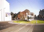 Image 22396 (118k, 850x562) Photo by: Bernard Chatreau Location: Boutasse-Camille Rousset | 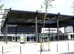 Image 49205 (184k, 792x584) Photo by: Peter Ehrlich Location: La Doua-Gaston Berger | 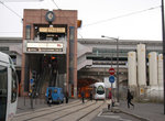 Image 63157 (171k, 864x574) Photo by: Peter Ehrlich Location: Suchet | 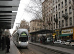 Image 63166 (215k, 864x574) Photo by: Peter Ehrlich Location: Suchet | 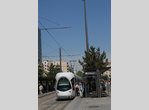 Image 72845 (167k, 705x1043) Photo by: Thierry Leleu Location: Cours de la Liberté |
Photos By Location
T1
Photo locations: Perrache, Place Carnot, Cours de Verdun, Pont Gallieni, Quai Claude Bernard, Rue de l'Université, Rue de Marseille, Saint André, Guillotière, Cours de la Liberté, Palais de Justice-Mairie du 3ème (Moncey), Rue Servient, Part-Dieu Servient, Part-Dieu Vivier-Merle, Cours La Fayette, Avenue Thiers, Collège Bellecombe, Rue Henri Rolland, Charpennes, Le Tonkin, Place Jean Chorel, Rue Mozart, Condorcet, Rue des Emeraudes, Université Lyon 1, Campus de la Doua, La Doua-Gaston Berger, Avenue Albert Einstein, IUT-Feyssine, Suchet, Sainte-Blandine, Montrochet, Centre Berthelot, Avenue Berthelot, Jean Macé, Garibaldi-Berthelot, Route de Vienne, Villon, Bachut-Mairie du 8ème, Jean XXIII, Grange-Blanche, Avenue Rockefeller, Ambroise Paré, Vinatier, Essarts, Avenue Franklin Roosevelt, Boulevard Laurent-Bonneway, Boutasse-Camille Rousset, Hôtel de Ville-Bron, Les Alizés, Rue du 8 Mai 1945, Rebufer, Avenue de l'Université, Parilly, Europe-Université, Porte des Alpes, Parc Technologique, Hauts de Feuilly, Salvador Allende, Alfred de Vigny, St.-Priest Hôtel de Ville, Esplanade des Arts, Jules Ferry, Corière, St.-Priest Bel-Air
T2
Photo locations: Avenue de l'Université, Parilly, Europe-Université, Porte des Alpes, Parc Technologique, Hauts de Feuilly, Salvador Allende, Alfred de Vigny, St.-Priest Hôtel de Ville, Esplanade des Arts, Jules Ferry, Corière, St.-Priest Bel-Air
T3
Photo locations: Part-Dieu, Between Part-Dieu and Dauphine Lacassagne, Dauphine Lacassagne, Reconaissance Balzac, Gare de Villeurbaine, Bel Air-Les Brosses, La Soie, Décines Centre, Décines Grand Large, Meyzieu Gare, Meyzieu Z.I., Meyzieu Depot
Page Credits
By Bernard Chatreau.