BMT 4th Avenue Line
Overview
The 4th Avenue (Brooklyn) subway began service on June 22nd, 1915. It connected with the BMT's Sea Beach line to Coney Island, as well as the Manhattan Bridge and ran to Chambers Street, Manhattan, over the Manhattan Bridge. This was the first service in the 4th Avenue subway, as well as the first over the bridge. In addition, the first steel cars operated by the BRT (and BMT), the 67' standards, operated over this route. The route was also opened from 85th St, Brooklyn, to Chambers St, Manhattan, in 1916. In 1920, trains ran from 86th St, and the line was extended further south to 95th St (the present day terminal) in 1925. Trains originating from 95th St ran via the Montague St tunnel and the Broadway (Manhattan) subway into Astoria, Queens.
It should be noted that the tracks on the Manhattan Bridge were ready for service shortly after the bridge's opening day (December 31st, 1909). However, they were not connected to any tunnel routes on either side of the bridge, because none existed! In 1912, the Manhattan Bridge Three Cent Line, a trolley company, began running trolleys over the subway tracks on a temporary basis until 1915, when the trolleys were moved to the upper roadways and the BRT subway opened. The trolleys ran over the Manhattan Bridge until 1929, when the auto won out over the streetcar.
The 4th Avenue subway was built jointly by the New York Municipal Railway Corporation (a BRT/BMT subsidiary set up for the Dual Contracts) and the City of New York. The BRT had already built the section between Flatbush Avenue Extension, Fulton St, Ashland Place and 43rd St / 4th Avenue before the Dual Contracts were signed. That section of the line was originally intended to be part of the 1908 "TriBorough Plan". The line runs through part of the site of the Battle of Long Island, and since the ground was filled in from the days of the Revolutionary War, it was expected that artifacts from that battle would be found during construction. None were ever found.
The subway is 4 tracks from Pacific Street to 65th Street. At 36th St, the West End Line connection can be found; at 59th St, the Sea Beach connection can be found. From 65th St to 95th St, the subway is two tracks, and they were built in the west side of 4th Avenue, so that two additional tracks could be laid in the future if traffic ever warranted it.
Provisions for this expansion are visible at several locations along the existing 4th Ave. Subway. The subway is carried in the lower deck of a bridge over the LIRR Bay Ridge branch cut, and here it can be seen that the bridge has four trackways of which only the western two are used. The tunnel leading up to each side of the bridge was built only for the existing two tracks. At Bay Ridge Ave. and 77th St. stations, the southbound platform has the usual columns, but the northbound, being where a trackway would be if expanded, does not. At 86th St, the southbound track swings out around the platform, but the northbound is straight (from the north); in other words, this would be the western half of an express station.
Today, 4th Avenue subway service is composed of R-46s and R-32s on the N line, R-46s and an occasional R-32 on the R line, R-68s and an occasional slant R-40 on the B line, and R-42s on the M line when it runs during rush hours to Bay Parkway, Brooklyn.
Planned Expansion to Staten Island
The original Dual Contracts plan provided for a tunnel under the Narrows from southern Brooklyn/Bay Ridge to Staten Island. The tunnel was intended to leave the 4th Avenue subway at 65th St, Brooklyn, and would have entered Staten Island midway between St. George and Stapleton, and would have had branches to each. The 4th Avenue subway has four tracks between 59th and 65th Streets, two of which were intended for the Staten Island connection.
The Staten Island link might have been built in several different ways. It is likely that a full 4-track subway to Fort Hamilton would only have made sense if it led to a Narrows tunnel. A different plan, which got as far as engineering drawings and even some excavation, would have left the subway just south of 59th St, and you can see tunnel stub headings running straight from the local tracks immediately south of the station. Several different plans were drawn up for the Narrows tunnel, including a two track and a four track option.
Recent discussions of a railroad freight tunnel across New York Harbor from New Jersey via Staten Island may once again bring about discussion of connecting the subway to Staten Island. It is likely that any tunnel built would be designed to tie into the LIRR's Bay Ridge Branch across southern Brooklyn to East New York, Fresh Pond, and via the New York Connecting Railroad to the Hell Gate Bridge.
Construction
Sections:
Route 11-A Broadway-Fourth Avenue Subway
- 1. Ashland Place and Fourth Avenue - Fulton St. to Sackett St.
- 2. Fourth Avenue - Sackett St. to 10th St.
- 3. Fourth Avenue - 10th St. to 27th St.
- 4. Fourth Avenue - 27th St. to 43rd St.
Route 11-B Broadway-Fourth Avenue Subway
- 1. Fourth Avenue - 43rd St. to 61st St.
- 2. Fourth Avenue - 61st St. to 86th St.
- 3. Fourth Avenue - 86th St. to 95th St.
Route 33 Whitehall St., East River, and Montague Street
- 2A. Whitehall St. to Montague and Clinton Sts.
- 3. Montague, Fulton, and Willoughby Sts. - Clinton St. to Flatbush Ave. Extension; Clinton St. to Borough Hall
- MB-Ex 1. Flatbush Avenue Extension - Nassau Street to Willoughby Street
Click through for a separate page of photographs of the construction of the 4th Avenue Subway.
Railfan Perspective
It's a long ride from 95th Street to Pacific Street on the R line, and the rolling stock on the line (a mixture of R-46, R-68, and R-160 types) all have obstructed front windows. It's a shame, too, because the express run from 36th Street to Pacific Street, has some downgrades that allow the train to gather up some excellent speed. So, from a cab view standpoint, there isn't much going for it here.
From a historical perspective, several things make the line interesting. There exists trackways south of 36th Street station that dive under the mainline tracks. There was an abandoned mezzanine somewhere south of the present station which was "stranded" when the present ramps from the West End Line were built and the station was extended northward. Legend has it that 86th St was intended to be used for some unknown purpose, because it has a very wide island platform and a mezzanine, ala the IND. As the original terminal before 95th St was built, it may have been three tracks, and the center platform was built over the center track when the line was extended to 95th St.
Opening/Closing Dates
| Station | Opened | Closed |
|---|---|---|
| Myrtle Avenue | 6/22/1915 | 7/16/1956 |
| DeKalb Avenue | 6/22/1915 (4th Avenue Line), 8/1/1920 (Brighton Line) | |
| Pacific Street (Atlantic Avenue–Barclays Center) | 6/22/1915 | |
| Union Street | 6/22/1915 | |
| 9th Street | 6/22/1915 | |
| Prospect Avenue | 6/22/1915 | |
| 25th Street | 6/22/1915 | |
| 36th Street | 6/22/1915 | |
| 45th Street | 9/22/1915 | |
| 53rd Street | 9/22/1915 | |
| 59th Street | 9/22/1915 | |
| Bay Ridge Avenue | 1/15/1916 | |
| 77th Street | 1/15/1916 | |
| 86th Street | 1/15/1916 | |
| 95th Street-Fort Hamilton | 10/31/1925 |
Station by Station
Manhattan Bridge
The line starts by crossing the Manhattan Bridge, which has its own page of information.
Myrtle Avenue (Abandoned)
Artwork Masstransiscope (Bill Brand, 1980)
The station at Myrtle Avenue was part of the original Manhattan Bridge line and was open from 1915 to 1956. It was closed in order to facilitate rebuilding of the junctions north of DeKalb Ave. leading to and coming from the bridge. The southbound platform at Myrtle Ave. was demolished completely (some wall tile remains). Myrtle Avenue station was sometimes called Gold Street in early maps and documents.
The northbound platform is mostly intact and hosts an artwork installation similar to a flat "zoetrope" entitled Masstransiscope.
 Photo by: Martha Cooper |
DeKalb Avenue
Artwork DeKalb Improvisation (Stephen T. Johnson, 2004)
BRQ![]()
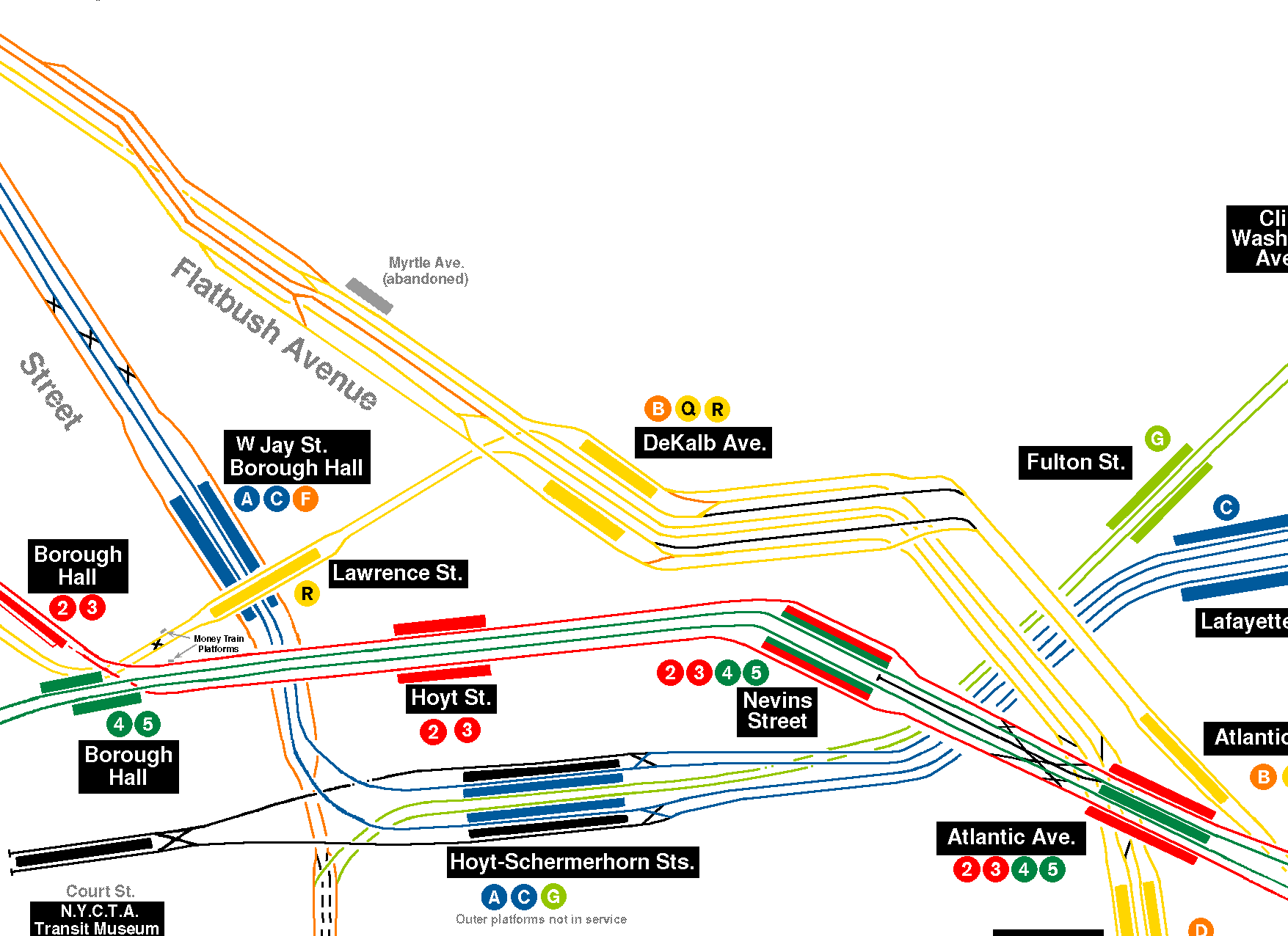
At the Brooklyn end of the Manhattan Bridge, both sets of bridge tracks, plus the set from the Montague Street Tunnel, feed into the massive DeKalb Avenue Station, which opened as part of the 4th Avenue Line subway construction on June 22, 1915. DeKalb Avenue is a six-track station, in an unusual configuration of local-express-super express tracks. There are two island platforms, with a track on each side, plus two more tracks down the middle, which do not have a platform face. There are north and south mezzanines with fare control and an active interlocking tower in the center platform crossover. Mosaics are limited to a large "DeKalb" name tablet.
This station was extensively rebuilt in the mid 1950s by cutting off about 20m off of the south end and extending the north end by about 80m. The north end of both platform extensions are split with the "express" portion being lower than the "local" portion as the express tracks descend to the Montague St. tunnel. The north end exit was built as part of the extension as well.
At the north end of the original station, where the 1950s extension begins, is a switch well between the 'tunnel' and 'bypass' tracks. The switch, removed with the rebuild of the 1950s, crossed trains from the both the bridge and bypass tracks (heading uptown) to the tunnel track. Symmetrical switches was on the downtown side. The switch plant was removed during the station extension.
There is the remains of a turning loop, a larger version of the City Hall loop on the IRT East Side line, in the tunnel between DeKalb Avenue and Manhattan Bridge. It diverts from the uptown north side track and rejoins onto the downtown south side track. The loop passes under all four bridge tracks. It's likely that the loop was never actually finished with trackwork. The theory is that when DeKalb Avenue was built there was still uncertainty about the placement of lines on the Manhattan side of the bridge (which resulted in some changed plans on the BMT Broadway line and the disused lower level of BMT City Hall). Trains would not cross the bridge for lack of connections on the far end. So this loop was designed in order to get some subway service going in Brooklyn. When the Manhattan lines were sorted out and connected to the bridge, the loop plan was no longer necessary.
Currently, the services operating on the Brighton Line via the Manhattan Bridge use the local-side tracks, and the services operating on the 4th Avenue line via the Montague Street tunnel use the express tracks (with platform). West End and Sea Beach services use the center bypass tracks. Service south of DeKalb Ave. is operated via the BMT Brighton Line and the BMT 4th Avenue Line, with further service along the BMT West End Line and the BMT Sea Beach Line.
Manhattan-bound services lead to the BMT Broadway Line (via bridge and tunnel), and the IND 6th Avenue Line. A former connection on the Manhattan side to the BMT Nassau Street-Jamaica Line was severed in 1967.)
Please note: because of route changes over the years, and for ease of location identification, all of the photos on this site of the DeKalb Avenue station are marked "BMT 4th Avenue Line" even if the trains were Brighton Line trains.
 Collection of: David Pirmann |
 Photo by: Robbie Rosenfeld |
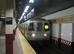 Photo by: Michael Hodurski |
 Photo by: Doug Grotjahn |
 Photo by: Ed Watson/Arthur Lonto Collection |
| More Images: 1-50 51-100 101-150 151-159 | ||||
Pacific Street (Atlantic Avenue–Barclays Center)
Artwork MoMA Atlantic/Pacific (2009)
DNR![]() Express station with four tracks and two island platforms. The station
platform area has been renovated and features sea foam green accents
on the niches in the center curtain wall. The south ends of the
platforms are narrower. The mezzanine is at the north end, 34 steps up
from the platform. This end of the platform has a high
ceiling. Further renovation including ADA-compliant elevators are
planned for the entire Atlantic Ave./Pacific St. complex. Some niches
are blocked by equipment and are highlighted by bright yellow
tile. The platforms extend further north into the tunnel and afford a
glimpse of the old tile. Although renovated, the station is still
rather bland.
Express station with four tracks and two island platforms. The station
platform area has been renovated and features sea foam green accents
on the niches in the center curtain wall. The south ends of the
platforms are narrower. The mezzanine is at the north end, 34 steps up
from the platform. This end of the platform has a high
ceiling. Further renovation including ADA-compliant elevators are
planned for the entire Atlantic Ave./Pacific St. complex. Some niches
are blocked by equipment and are highlighted by bright yellow
tile. The platforms extend further north into the tunnel and afford a
glimpse of the old tile. Although renovated, the station is still
rather bland.
Some relatives depths of stations in the Atlantic Avenue/Pacific Street complex are as follows (measurements unscientific, +/- 10 feet):
- LIRR Station, 20 feet below street
- IRT Station, 20 feet below street
- BMT (D/Q) Station, 50 feet below street
- BMT (M/N/R) Station, 40 feet below street
 Photo by: Andrew Johnson |
 Photo by: David-Paul Gerber |
 Photo by: Christopher Henderson |
 Photo by: Bernard Chatreau |
 Photo by: Bernard Chatreau |
| More Images: 1-50 51-88 | ||||
Union Street
Artwork CommUnion (Emmett Wigglesworth, 1994)
R A local station with typical 1970s renovation large white wall tiling. This station does not have a color section but rather a strange looking horse design where the color would be. Every other niche is highlighted by mutli-colored diamond pattern tiles. Curtain walls separate all four tracks. The fare control is at the south end of the platforms, and there is no crossover or crossunder present.
 Photo by: Wayne Whitehorne |
 Photo by: Wayne Whitehorne |
 Photo by: Robbie Rosenfeld |
 Photo by: Roberto C. Tobar |
 Photo by: Roberto C. Tobar |
| More Images: 1-23 | ||||
9th Street
Artwork Sorry, no artwork here.
Transfer to IND Crosstown Line
R A local station with transfer to the IND Crosstown (F/G) lines at the south end of the platforms. Accent color is golden yellow, and a numeral "9" mosaic is present in the mezzanine and platform area.
 Photo by: Wayne Whitehorne |
 Photo by: Michael Hodurski |
 Photo by: Michael Hodurski |
 Photo by: Michael Hodurski |
 Photo by: Roberto C. Tobar |
| More Images: 1-28 | ||||
Prospect Avenue
Artwork Duration (Monika Bravo, 2017)
R A local station, with blue accent tiling and a small "P" mosaic in the tile near the fare control. There is no crossover or crossunder and the fare control is at platform level in the center. Curtain walls separate all four tracks.
 Photo by: Wayne Whitehorne |
 Photo by: Michael Hodurski |
 Photo by: Michael Hodurski |
 Photo by: Roberto C. Tobar |
 Photo by: John Dooley |
| More Images: 1-34 | ||||
25th Street
Artwork Sorry, no artwork here.
R Local station with burnt orange accent color tile. In other respects resembles Prospect Ave.
 Photo by: Wayne Whitehorne |
 Photo by: Michael Hodurski |
 Photo by: Michael Hodurski |
 Photo by: Roberto C. Tobar |
 Photo by: Jose Garrido |
| More Images: 1-17 | ||||
36th Street
Artwork An Underground Movement: Designers, Builders, Riders (Owen Smith, 1998)
Transfer to BMT West End Line
DNR
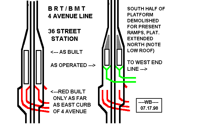
Express station with two island platforms. Fully renovated. South of this station are the turnouts from the 4th Avenue Line to the BMT West End Line, which heads to Coney Island. These turnouts have a very interesting history. The original construction was a four track turnout into 40 Street to connect to what was then to be known as the New Utrecht Av Line. The connection was built as far as the southeast corner of 39 St and 4 Av. The northbound local track was to connect at grade but the other three tracks passed under the 4 Avenue Line. The trackways are about 70 feet deep and now are below ground water. With the signing of the Dual Contracts it was decided to make the connection via the "Culver Cut" which was then used for Culver and West End trains to reach the waterfront. To do this the original platforms had to be moved further north and the original south mezzanine was closed off although it is still intact and can be reached by a stairway in the tunnel. Rumor has it that a kind of glass ceiling tile which permitted light from the street to enter the mezzanine enabled one to see into the mezzanine. Part of the closed off area is now used as a signal relay room. Thanks to Mr. W. Boylan, a map of this changed layout is available.
 Photo by: Dante D. Angerville |
 Photo by: Danny Molina |
 Photo by: David-Paul Gerber |
 Photo by: Zach Summer |
 Photo by: John Dooley |
| More Images: 1-50 51-59 | ||||
45th Street
Artwork Sorry, no artwork here.
R Local station with dark grey accent tile, blue/grey round columns on the platform level, and directional mosaics in the mezzanine (the mosaics seem reversed here; "Uptown" points to the side of the station heading south, and "Downtown" points toward the Manhattan-bound side. I presume that in this case, downtown refers to heading towards downtown Brooklyn and uptown away from downtown Brooklyn). The north exit at 45th St. has a crossover; the south exit at 46th St. is closed.
 Photo by: Wayne Whitehorne |
 Photo by: Michael Hodurski |
 Photo by: Michael Hodurski |
 Photo by: Roberto C. Tobar |
 Photo by: Roberto C. Tobar |
| More Images: 1-16 | ||||
53rd Street
Artwork Untitled (Mickalene Thomas, 2017)
R Local station. Golden yellow accent tile and the platforms have the same round columns as found at 45th St. The north exit at 52nd St. is an iron maiden exit only, while the south exit at 53rd St. has a mezzanine with crossover. Tile on the stairs at the south end is yellow and gold. Mosaics in the mezzanine indicate "Ft Hamilton and Coney Island" and "Downtown." (As at 45th St., downtown indicates to downtown Brooklyn.) The mezzanine has an odd jog in the passageway leading to the fare control.
 Photo by: Michael Hodurski |
 Photo by: Roberto C. Tobar |
 Photo by: John Dooley |
 Photo by: John Dooley |
 Photo by: John Dooley |
| More Images: 1-50 51-53 | ||||
59th Street
Artwork Sorry, no artwork here.
Transfer to BMT Sea Beach Line
RN![]() Express stop, two island platforms and four tracks. There
are exits at both ends, with the south exit at 60th St. open part
time. Both ends have crossovers and the uptown/downtown directional
mosaics mentioned above. The southbound platform has route selector
boxes. The station has a faded/dirty name tablet at platform level.
After this station, the BMT Sea Beach Line diverges for Coney Island.
Express stop, two island platforms and four tracks. There
are exits at both ends, with the south exit at 60th St. open part
time. Both ends have crossovers and the uptown/downtown directional
mosaics mentioned above. The southbound platform has route selector
boxes. The station has a faded/dirty name tablet at platform level.
After this station, the BMT Sea Beach Line diverges for Coney Island.
 Photo by: Zach Summer |
 Photo by: Roberto C. Tobar |
 Photo by: Aliandro Brathwaite |
 Photo by: Bernard Chatreau |
 Photo by: Jose Garrido |
| More Images: 1-34 | ||||
Bay Ridge Avenue
Artwork Strata (Katy Fischer, 2017)
R Just prior to entering Bay Ridge Avenue station, daylight is briefly visible as the tracks pass over the Bay Ridge Branch of the LIRR. The station has two side platforms with blue accent tile. The north exit at 68th St. is an iron maiden exit, and the south exit has a mezzanine and crossover. No mosaics were observed, either in the tile band in the mezzanine or elsewhere.
 Photo by: Wayne Whitehorne |
 Photo by: Michael Hodurski |
 Photo by: John Dooley |
 Photo by: John Dooley |
 Photo by: Robbie Rosenfeld |
| More Images: 1-44 | ||||
77th Street
Artwork Sorry, no artwork here.
R Local station with burnt orange accent tile and gold-painted columns. The north exit at 76th St. is an iron maiden exit, while the south exit has a mezzanine, crossover, and tiled-over newsstand (a raised sign remains). Stairs feature a red non-slip coating on the treads and risers.
 Photo by: Michael Hodurski |
 Photo by: Michael Hodurski |
 Photo by: Michael Hodurski |
 Photo by: Roberto C. Tobar |
 Photo by: Roberto C. Tobar |
| More Images: 1-18 | ||||
86th Street
Artwork Heydays (Amy Bennett, 2011)
R![]() Local stop with two tracks and one island platforms. 86th Street
station was planned to be an express station. The plan for conversion
had the present platform acting as the downtown local and express and
new works to the east would contain the uptown tracks and
platform. The trackside walls were once tiled, but went without tile
for many years; new tile was installed 2010-2011. There is a closed
tower on the extreme north end of the island platform, which is now
used for storage.
Local stop with two tracks and one island platforms. 86th Street
station was planned to be an express station. The plan for conversion
had the present platform acting as the downtown local and express and
new works to the east would contain the uptown tracks and
platform. The trackside walls were once tiled, but went without tile
for many years; new tile was installed 2010-2011. There is a closed
tower on the extreme north end of the island platform, which is now
used for storage.
Exits are at the north end and the center. The 85th St. exit has a part-time token booth and a high exit; while the main exit at 86th St. has a crossover and full-time booth. At the north end there are some closed stairways.
This station served as a temporary terminal from 1916 to 1925.
Exit here for bus service to Staten Island and the main Bay Ridge shopping district.
 Photo by: Wayne Whitehorne |
 Photo by: John Dooley |
 Photo by: Michael Hodurski |
 Photo by: Michael Hodurski |
 Photo by: Robbie Rosenfeld |
| More Images: 1-31 | ||||
95th Street-Fort Hamilton
Artwork Sorry, no artwork here.
R Final stop. The island platform has exits to 93rd at the north end and 95th at the south end of the full mezzanine with booths at both ends. A passageway outside the fare control allows access, when open, from either end to the main booth at 95th.
 Photo by: Wayne Whitehorne |
 Photo by: Richard Panse |
 Photo by: Michael Hodurski |
 Photo by: Roberto C. Tobar |
 Photo by: Robbie Rosenfeld |
| More Images: 1-35 | ||||
Page Credits
By Mark S. Feinman, Peggy Darlington, David Pirmann, and Joe Brennan.