TTC Yonge-University-Spadina Subway
![]()
Two TR trains at Rosedale on the TTC Yonge-University-Spadina Subway. Photo by Seth McDermott, December 2012.
Overview
Station Characteristics
| Station | Opened | Platforms | Rail Interchanges | Construction | Fare-Paid Terminal | Accessible | PRESTO |
|---|---|---|---|---|---|---|---|
| Downsview | March 31, 1996 | Island | None | Cut-and-cover | Bus | Yes | Yes |
| Wilson | January 28, 1978 | Island | None | In quasi-elevated road median | Bus | No | No |
| Yorkdale | January 28, 1978 | Island | None | In quasi-elevated road median | None | No | Yes |
| Lawrence West | January 28, 1978 | Island | None | In road median in open cutting | Bus | No | No |
| Glencairn | January 28, 1978 | Island | None | In road median in open cutting | None | No | No |
| Eglinton West | January 28, 1978 | Side | None | Cut-and-cover + in road median in open cutting | Bus | Yes | No |
| St. Clair West | January 28, 1978 | Side | 512 St. Clair | Cut-and-cover | Streetcar & bus | No | No |
| Dupont | January 28, 1978 | Side | None | Cut-and-cover | None | No | No |
| Spadina | January 28, 1978 | Side | Bloor-Danforth Line, 510 Spadina | Cut-and-cover | Streetcar & bus | No | No |
| St. George | February 28, 1963 | Island | Bloor-Danforth Line | Cut-and-cover | Bus | Yes | Yes |
| Museum | February 28, 1963 | Island | None | Cut-and-cover | None | No | No |
| Queen's Park | February 28, 1963 | 2 central single platforms | 506 Carlton | Bored tunnel | None | Yes | Yes |
| St. Patrick | February 28, 1963 | 2 central single platforms | 505 Dundas | Bored tunnel | None | No | Yes |
| Osgoode | February 28, 1963 | Island | 501 Queen, 502 Downtowner | Cut-and-cover | None | Yes | No |
| St. Andrew | February 28, 1963 | Island | 503 Kingston Road (walking transfer), 504 King, 508 Lake Shore | Cut-and-cover | None | Yes | No |
| Union | March 30, 1954 | Island (being converted to 1 central single platform + 1 side platform) | 503 Kingston Road (walking transfer), 509 Harbourfront, 510 Spadina; all GO Train lines, VIA Rail Canada | Cut-and-cover | Streetcar | Yes | Yes |
| King | March 30, 1954 | Side | 503 Kingston Road, 504 King, 508 Lake Shore | Cut-and-cover | None | No | No |
| Queen | March 30, 1954 | Side | 501 Queen, 502 Downtowner | Cut-and-cover | None | Yes | No |
| Dundas | March 30, 1954 | Side | 505 Dundas | Cut-and-cover | None | Yes | Yes |
| College | March 30, 1954 | Side | 506 Carlton | Cut-and-cover | None | No | Yes |
| Wellesley | March 30, 1954 | Side | None | Cut-and-cover | Bus | No | No |
| Bloor-Yonge | March 30, 1954 | Side | Bloor-Danforth Line | Cut-and-cover | None | Yes | Yes |
| Rosedale | March 30, 1954 | Side | None | Open cutting | Bus | No | No |
| Summerhill | March 30, 1954 | Side | None | Cut-and-cover | None | No | No |
| St. Clair | March 30, 1954 | Side | 512 St. Clair | Cut-and-cover | Streetcar & bus | Yes | No |
| Davisville | March 30, 1954 | 1 side + island (3 tracks) | None | Open cutting | Bus | Yes | No |
| Eglinton | March 30, 1954 | Island | None (Eglinton Line c. 2020) | Cut-and-cover | Bus | Yes | No |
| Lawrence | March 31, 1973 | Island | None | Cut-and-cover | Bus | None | No |
| York Mills | March 31, 1973 | Island | None | Cut-and-cover | Bus | Yes | Yes |
| Sheppard-Yonge | March 30, 1974 | Island | Sheppard Line | Cut-and-cover | Bus | Yes | No |
| North York Centre | June 18, 1987 | Side | None | Cut-and-cover | None | Yes | No |
| Finch | March 30, 1974 | Island | None | Cut-and-cover | Bus | Yes | Yes |
Station By Station
Downsview
Wilson
Yorkdale
Lawrence West
Glencairn
Eglinton West
St. Clair West
Dupont
Spadina
St. George
Museum
Queen's Park
St. Patrick
St Patrick, located at University Avenue & Dundas Street West, is named for St Patrick's Church. (There is a nearby St Patrick Street; however, it runs parallel to University Avenue, and was also named for the church). Fittingly, the station's colours are light green with dark green trim.
St Patrick (like Queen's Park) is built in twin bored tunnels, resembling a London Tube station. Two vestibules, at the far north end and the midpoint, link the otherwise separate halves of the island platform. One mezzanine is positioned over the north half of the platform; from the mezzanine there are 4 exits – one to each corner of Dundas Street & University Avenue. The southwest exit is inside the footprint of an office building, and the other three connect directly to the sidewalk.
At the far south end of the platform is a closed cross-passage between the two tubes. Like those at Queen's Park and Museum, it was closed for security reasons, as it serves no purpose that the escalator vestibules do not perform, and is far from a TTC employee's watch. It is now used as a storage room.
Osgoode
Osgoode, located at University Avenue & Queen Street West, is named for Osgoode Hall (on the northeast corner), a National Historic Site and the former home of the most historic and prestigious law school in Upper Canada. There is one mezzanine, positioned over the platform, somewhat toward the south end. Two fare control lines are positioned to the north and south of a central unpaid zone; the north fare control line is staffed, and is fully accessible with elevator access in the paid zone; the south fare control does not have its own booth, but consists of half-height turnstiles because it is within sight of the booth on the north line.
Exit passages lead east and west of the mezzanine, and branch into corridors leading to each corner of Queen & University; the northwest and northeast exits each consist of one staircase to street level; the southwest exit consists of two staircases – one to University Avenue, and the other to Queen Street and eastbound 501 and 502 streetcars. Lastly, the southeast exit used to consist of a staircase to street level, but has been reconfigured to connect to the basement of the Canadian Opera Company, through which one can reach the sidewalk; this exit also provides elevator access to the surface. The former staircase has been retained as a ventilation shaft, covered by grates in the sidewalk and on the wall of the passage below.
Osgoode and St Andrew share the closest spacing of any two TTC stations: barely one train length separates the two platforms. A blind central storage track with just enough room for one train connects to both running tracks immediately south of the Osgoode Station platform – the ends of the platform taper slightly, and ends at a bumper block directly behind the wall at the north end of St Andrew.
St. Andrew
St Andrew, located at University Avenue & King Street West, is named for St Andrew's Church. There is one mezzanine, positioned over the platform, somewhat toward the south end. Two fare control lines are positioned to the north and south of a central unpaid zone; the north fare control line is staffed, and is fully accessible with elevator access in the paid zone; the south fare control does not have its own booth, but consists of half-height turnstiles because it is within sight of the booth on the north line.
Exits directly to street level are positioned on the northeast, northwest and southwest corners. The northeast and northwest exits consist of one staircase, while the southwest exit consists of two staircases – one to University Avenue and the other to King Street and eastbound 504 and 508 streetcars.
St Andrew is very well-connected underground; the mezzanine forms part of the PATH network of pedestrian tunnels. An exit to the southeast corner leads to the food and retail concourse of 145 King West, through which the sidewalk can be reached; this exit also provides an elevator link to the surface. Other underground connections link to 200 King West (on the northwest corner), Metro Hall and Roy Thompson Hall (to the southwest, via a long corridor), and the Sun Life Tower (on the northeast corner), through which the greater PATH network can also be accessed.
In recent years, St Andrew has been highlighted as an example of the TTC's seemingly loose commitment to stated completion dates, as several projects at the station have dragged out far longer than first anticipated. The elevator retrofit, finally completed in June 2012, was originally planned to be opened years previously, but a dispute with the contractor forced the TTC to take legal action, leaving the project in stasis for some time. Moreover, much of the ceiling and wall finishes at St Andrew have been removed, ostensibly for structural inspection and maintenance. While there is evidence of work underway, this has dragged out considerably longer than first indicated by the TTC. The stripping of finishes has, however, provided a rare opportunity to see the original Vitrolite panelling, still in place. Years of neglect have resulted in extreme damage, captured in the photographs of the platform.
Amid the shambolic state of its other projects, St Andrew has also been used as a testing ground for new station finishes. The south end of the station has seen its soft yellow tinted fluorescent lights replaced with bluish models which, compounded with the blue wall tiles on the platform, gives the station's atmosphere an unusually crisp edge compared to the softer glow of other stops. Curiously, a section of wall at the far south end of the southbound platform has been given an experimental new wall treatment; for whatever reason this has not carried over to the rest of the station, and has started to show its own age.
St Andrew and Osgoode share the closest spacing of any two TTC stations: barely one train length separates the two platforms. A blind central storage track with just enough room for one train connects to both running tracks immediately south of the Osgoode Station platform – the ends of the platform taper slightly, and ends at a bumper block directly behind the wall at the north end of St Andrew.
Union Station
King
3 exits:
- Main mezzanine (northern end, under King & Yonge) with stairs to each corner and PATH connection; transfer to 504 King, 508 Lake Shore and eastbound 503 Kingston Road streetcars outside fare-paid zone at southwest and northeast corners
- Commerce Court (southern end) (Automatic Entrance) - direct basement access to PATH system; street access via PATH
- Melinda Street (extreme south end) (unstaffed) - exit only, accessible from the southbound platform only. Special Note: Melinda Street is the only unstaffed exit in the subway system with no turnstile; the fare barrier is provided only by a door on the landing, which is pushed outward to exit, and does not have handles on the unpaid side to pull it open.
Awkwardly, westbound 503 Kingston Road streetcars pass one block south of Melinda Street, on Wellington Street. Transfers between the subway and streetcars are honoured despite the short walk between stops. This is the only location on the TTC network where a subway line intersects a regularly serviced streetcar route without a direct transfer. (Tracks on Richmond Street cross the Yonge line without a transfer, but these tracks are only used during diversions. Streetcar tracks on Adelaide cross both the Yonge and University Lines without a transfer, but these tracks are not physically passable.)
North of King, there is a diamond crossover. Several of these were installed along the original Yonge line, but they were never connected to the interlocking signal system, and never supplied with third rail power. Speculation varies that they were installed purely for diesel-powered work vehicles to use, or that they were a result of inexperienced rapid transit planning, in its infancy at the time in Canada. Whatever the reason for their initial inclusion, they were later removed when rails were replaced, as a cost-saving measure to avoid buying new, expensive switches that would not be used in regular operations.
Since that time, however, increasing crowding on the Yonge Line has resulted in more frequent service disruptions, and the TTC has seen it fit to re-install these crossovers to allow trains to turn back at more locations, in order to minimize service outages should an incident arise. Thus in 2012, the crossover was re-installed. It is not yet commissioned for use, as it is not connected to the signalling system to enable reversing procedures and the shutdown of signal blocks. This is planned for 2015, when the whole signalling system on the Yonge Line is to be upgraded from the current wayside system to cab-based moving block signals, to allow tighter scheduling of trains.
Queen
2 exits:
- "Albert Street" (extreme north end) - no longer at Albert Street, which disappeared when the Eaton Centre was built, occupying the entire distance from Queen to Dundas Streets. A glass atrium in the mall, crossing east-west, was purposely constructed on Albert Street's former course. Stairs lead to the east side of Yonge Street midway between Queen and Shuter Streets, and underground connections lead to two levels of the Eaton Centre.
- Main mezzanine (far south end), under Queen & Yonge) - separate northbound and southbound fare controls; stairs on the southwest and northwest corners lead to street level (within the footprints of the Eaton Centre and HBC buildings), and accesses to on all corners lead to the basement levels of neighbouring buildings, and the PATH system. The transfer to 501 Queen and 502 Downtowner streetcars is at street level, outside the fare-paid zone on the southwest and northeast corners.
The northeast, northwest and southwest entrances are accessible by elevator, but these are outside TTC property, and therefore notice may not be given when maintenance is being performed.
Crossunders are provided both inside and outside the fare-paid zone (for the benefit of PATH users, as the subway platforms are directly under street level). Special Note: these crossunders utilize Lower Queen, an unfinished lower level built in anticipation of Queen streetcars being rerouted into a tunnel through downtown, which never materialised). The fare-paid crossunder utilizes the roughed-in eastbound streetcar platform, while the fare-unpaid crossunder utilizes the westbound platform. Elevator access was later added to the unpaid side, in the westbound trackway. (Users requiring elevator access cannot cross the tracks within the fare-paid zone.)
Dundas
1 exit per platform, connected outside the fare-paid zone by an underpass. Accesses lead to Dundas Street on the northwest corner, Yonge-Dundas Square on the southeast corner, and underground connections lead to the PATH, Eaton Centre, the Atrium on Bay (leading to the Metro Toronto Coach Terminal), 10 Dundas East, and a municipal parking garage under the square.
Transfer to 505 Dundas streetcars is available outside the fare-paid zone, at street level via the Eaton Centre (southwest) and 10 Dundas East (northeast) corners.
The southwest, southeast, and northeast entrances are all fully accessible by elevator, although these are outside TTC property, and therefore are not necessarily listed when under maintenance.
Dundas is the only TTC Subway/RT station without a crossover/crossunder within the fare-paid zone, due to the shallow tunnel (directly below street level) and the various utility corridors and existing passageways. Signs are posted to warn passengers, and those who miss the signs can take a paper transfer as proof of payment before crossing to the other side.
College
1 exit:
- Main mezzanine (northern end, under College/Carlton & Yonge) with stairs to street level on the southeast and northeast corners, and an underground connection to College Park and the CARLU on the southwest corner. Transfer to 506 Carlton streetcars is at street level outside the fare-paid zone, on the southwest and northeast corners.
South of College is a diamond crossover. Similar to the crossover north of King, the original tracks were removed to save costs, but reinstalled in 2011 to reduce the impacts of service disruptions. The switches are however still inactive, as they have not been connected to the interlocking signal system.
College Station is situated directly below Yonge Street. North of College, the Yonge Line shifts east of Yonge Street, running under private properties.
Wellesley
1 exit:
- Headhouse (southern end), on the north side Wellesley Street, east of Yonge. The headhouse contains fare controls and bus platforms within the fare-paid zone. The bus platforms are fully accessible, while subway access is not.
Bloor-Yonge
Rosedale
1 exit:
- Headhouse, at street level at the north end of the station, on the south side of Crescent Road, immediately west of the bridge carrying the street over the tracks, and east of Yonge. Also connected to the headhouse is a bus platform within the fare-paid zone. The bus platform is accessible, while the subway is not.
Rosedale is one of two TTC stations (the other being Davisville) without a roof covering the tracks; each of the platforms has its own canopy.
Summerhill
1 exit:
- Headhouse at the extreme north end of both platforms, at street level on the north side of Shaftesbury Avenue, east of Yonge. Summerhill Station is not actually connected to Summerhill Avenue, which is one block north of the station’s north end.
Summerhill is the most lightly trafficked station on the Yonge side of the Yonge-University-Spadina Line (only Glencairn on the Spadina Line is more lightly used), having no surface route connections aside from the 97 Yonge bus.
Near the south end of the platforms, the CP North Toronto Freight Line crosses over the subway. The former North Toronto Station, at Yonge Street & Scrivener Square, was shuttered after all passenger services were consolidated at Union Station downtown, and has since been converted to an LCBO (Liquor Control Board of Ontario) store. There have been proposals to reopen North Toronto Station to GO commuter service to relieve some of the crowding at Union, and provide a transfer to the subway at Summerhill, however this presents three logistical problems (in ascending difficulty):
- The current Summerhill Station headhouse is not conveniently positioned to allow for transfers, being a block away from the rail line, and is nowhere near large enough to handle the anticipated volume of commuter traffic. Theoretically this could be solved by creating a new southern platform access, directly to the rail station above.
- The North Toronto Line is the main freight route through the city, bypassing the Union Station rail corridor downtown, and CP is very adversarial to the desire of GO to expand passenger service over its tracks.
- The Yonge Line is already over capacity, and would not be able to absorb the extra flow of passengers. Commuters transferring from Union flow in the counter-peak direction, allowing the system to handle the high volumes, but at Summerhill, commuters would have to board already overcrowded trains.
Because of these various logistical problems, it is unlikely that Summerhill will become a commuter rail interchange any time in the near future.
North and south of Summerhill, trains used to run in an open trench. This was gradually covered over as the TTC sold air rights in the affluent neighbourhood around the station, and due to the concerns of condominium developers along the line over the potential noise of the subway. Several buildings were built directly straddling the tracks, while the rest of the trench between Summerhill and St Clair had decking installed, which was then covered with grassy parkland. This decking is strong enough to support pedestrians, but not heavier motor vehicles, and so the road bridges that crossed the trench were left in place, complete with railings. Below, it is clear that the line still runs in a trench and not a true tunnel: the sides are sloped and earthen, with some vegetation growing under grates that allow in daylight; stumps of trees are also visible, along with old lamp posts, some of which have been sawed off, and others left as they were.
North of Summerhill, the Yonge Line climbs a 4% grade as it ascends the Lake Iroquois shoreline – the face of the glacial lake that once covered the southern end of Toronto. This is the dividing line between the historically more built-up city of Toronto and its original suburbs, annexed in the early 20th century, which now make up midtown Toronto.
St. Clair
2 exits per platform:
- Main Headhouse (far south end of the platforms), located east of Yonge, spanning the block from Pleasant Boulevard to St Clair Avenue – built into the sloping landscape, the south entrance from Pleasant Boulevard is one floor lower than the north entrance from St Clair Avenue. The south (lower) elevation has a bus terminal within the fare-paid zone, while the north (higher) elevation has a streetcar terminal for the 512 St Clair, also within the fare paid zone. Both entrances are regularly staffed. The entire headhouse is accessible, although the streetcars used on the 512 St Clair are not. There is also a direct underground link from the headhouse to the Scotiabank Building (1 St Clair East), with automatic fare control.
- St Clair Centre (northern end of the platforms) – directly linked to the basement level of the St Clair Centre, and to the northeast corner of St Clair & Yonge via a shopping concourse
St Clair is one of very few stations with a curved platform; the south end of the southbound platform has one of the most pronounced curves of any Toronto subway platform, as the Yonge Line veers from the right-of-way on the east side of Yonge Street to the west side on its journey northward.
South of St Clair is a diamond crossover, with the same history as those at College and King. It was reinstalled in 2012.
North of St Clair, the Yonge Line ascends out of the cut-and-cover tunnel into an open right-of-way on the west side of Yonge Street, fluctuating between an open cut and an embankment as the elevation of the surrounding land changes.
Davisville
2 exits:
- Main Mezzanine (approximately at the middle of the platforms), with one staircase, one escalator, and one elevator all leading to the southwest corner of Yonge Street & Chaplin Crescent (across from the actual Davisville Avenue). At street level, the main entrance is inside the ground floor of the William McBrien Building, the TTC's Headquarters. Also at ground level inside the building is the station's bus terminal, which is inside the fare-paid zone. The fare control is located one level below, and the subway platforms below that, to the west in an open trench.
- Davisville Centre (extreme north end of the northbound platform only) (automatic entrance) – connected directly to the Davisville Centre office and apartment building; open Monday-Friday only.
Davisville is one of two TTC stations (the other being Rosedale) without a roof covering the tracks; each of the platforms has its own canopy.
Davisville station is directly adjacent to the Davisville Yard, the original Yard for the 1954 subway line. This makes for excellent trainspotting opportunities, including parts of the TTC's work fleet.
The station has a unique layout in the TTC system, consisting of one side platform and one island platform. The side platform, on the east side of the trench, receives northbound trains. The island platform generally receives southbound trains on its eastern face, resulting in a standard side platform operation. The western face of the island platform is internally referred to as the Davisville Buildup, and is used for trains entering or leaving service. Trains entering service at Davisville regularly accept passengers at the Buildup platform, and then proceed southbound. Similarly, southbound trains leaving service at Davisville leave the main line and discharge their passengers at the Buildup platform, before being shunted into the yard. When there is a service disruption at or near Davisville, southbound trains can be rerouted to avoid the obstruction and proceed to St Clair via the Buildup and yard leads instead of the usual southbound platform.
Davisville is the most haphazardly constructed and arranged station on the TTC system. Constructed as part of the original 1954 line, it has undergone many renovations and additions, leading to incongruous architectural styles and finishes, sloping and awkwardly angled passageways, and stairways and elevators punched through wherever they would fit. This gives the station a charming quality and a uniquely rich character compared to most other TTC stations.
Eglinton
The original northern Yonge Line terminus, Eglinton Station is a sprawling warren of passageways and concourses. From its opening until 1973, Eglinton functioned as the gateway to Toronto's rapidly growing suburban neighbourhoods – now firmly in midtown as a result of further decades of outward expansion. Eglinton is at the epicentre of the midtown area, now a satellite business district of downtown, and consequently Eglinton is one of the busiest non-interchange stations in Toronto. This is expected to change in 2020, when the Eglinton Crosstown Line is projected to open from Jane Street to Kennedy Station.
2 exits:
- Main mezzanine (extreme north end, under the southwest corner of Yonge & Eglinton) – underground connections to offices and shopping concourses on the northwest and southeast corners, access to Canada Square directly above the station on the southwest corner, and stairs to street level on the northwest and northeast corners. All corners include access to street level, either directly via stairs, or through public areas of buildings.
- Yonge Street, south of Eglinton (Automatic entrance) – connects to the subway, and directly to the bus terminal; one of the few automatic entrances on the Yonge-University-Spadina Line that is wheelchair accessible
The current bus terminal is a recent addition. Eglinton's original bus terminal was a sprawling affair with its own underground concourse, and individual, parallel platforms at street level with their own stairs, offloading and loading zones. Two terminals in the same format still are still in service at Islington and Warden Stations. This terminal was closed in 2004 due to structural deterioration of the concrete slab, and the bus terminal was moved to the "temporary" new facility, which has remained in use since, as a structural examination revealed that the original terminal was in much worse condition than previously thought. The terminal has stood derelict since, at the southeast corner of Eglinton and Duplex Avenues. On numerous occasions, there have been proposals for the TTC to sell the terminal's prime land in the highly-priced and growing Yonge & Eglinton district, but before that may take place, the space will be used as a staging area for construction of the Eglinton Line as it nears Yonge Street.
Lawrence
Two exits:
- Main mezzanine at the south end – a series of staircases and escalators from the platform lead to the underground bus terminal within the fare-paid zone, and the main fare control; stairs and escalators from the mezzanine lead to the surface on the northeast and northwest corners of Yonge & Lawrence
- Auxiliary unstaffed exit at the north end, with stairs to Ranleigh Avenue on the east side of Yonge Street, and Bedford Park Avenue on the west side of Yonge Street
Lawrence and York Mills are two of the deepest stations in the Toronto subway system, due to the topography of the land above; the auxiliary exit from Lawrence has five flights of stairs from the platform to the fare control (also reached by escalators), and a further two flights to the surface.
York Mills
Two exits from the platform:
- Main mezzanine at the north end of the platform. A tunnel within the fare paid zone links to the underground TTC bus terminal; tunnels outside the fare-paid zone provide indoor links to the Yonge Corporate Centre (stairs only), and the York Mills Centre office building (stairs, escalators and elevators), which also houses a GO commuter bus terminal. Another exit leads to the surface on the northeast corner of Yonge Street & Wilson Avenue
- Auxiliary exit at the south end of the platform, to Old York Mills Road, on the east side of Yonge Street; this functions as a makeshift kiss-and-ride point, with a marked area on the street
Lawrence and York Mills are two of the deepest stations in the Toronto subway system, due to the topography of the land above; the elevation of the land generally rises away from Lake Ontario, but York Mills Station is located under the west branch of the Don River, in a deep valley. The auxiliary exit from York Mills has five flights of stairs from the surface (also reached by escalators).
Sheppard-Yonge
North York Centre
4 separate fare controls lead to one large mezzanine; one is a staffed line of low turnstiles at the south end, one is an unstaffed line of full-height revolving turnstiles at the far north end, and the other two are single wheelchair accessible gates surrounding elevators to each platform. The fare-paid zones by the elevators are not connected, meaning that there is no paid crossover between platforms for customers requiring an elevator.
3 exits/entrances link to the mezzanine:
- A direct underground connection to the retail levels of Empress Walk, on the east side of Yonge Street; this exit features a rather awkward bank of 3 doors (pictured), interrupted by a column protruding into an already cramped vestibule area
- A direct underground connection to a retail concourse in North York Civic Centre (still signed as "City Centre", even though the city of North York was amalgamated into Toronto in 1998)
- A connection to Mel Lastman Square on the west side of Yonge Street, in a sunken, covered breezeway on the southern side of the North York Civic Centre
North York Centre, the TTC's only infill station to date, was originally planned concurrently with the rest of the North Yonge Line, under the working name "Empress" Station, after a nearby street. The station's construction was postponed indefinitely as a cost saving measure, as it was a "mid-block" stop, not located at the intersection of a concession road. When the line was built, provisions were made for future construction by building the tunnel straight and level.
The motivation for the station's eventual construction and name change was political in nature, as Mel Lastman, the (last – notice the pun) mayor of what was then the City of North York, wanted to increase the awareness of the city's new planned downtown, anchored on the subway. The City of North York was dissolved in 1998, along with Etobicoke, York, East York, Scarborough and the Old City of Toronto, to form the current "Megacity" of Toronto, but the North York area still maintains a sizeable satellite business district around North York Centre Station.
North York Centre's in-fill history is visible in that it retains the thick tunnel wall between the tracks, unlike all other side-platform stations on the network, which have open sight lines between platforms, afforded by either steel column supports or vaulted ceilings. This was to save on re-engineering the tunnel supports.
Finch
Route Map
Track Map
Photo Gallery
| Five Random Images | ||||
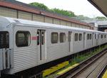 Image 34593 (112k, 640x480) Photo by: Michael Tricarico Location: Davisville Yard | 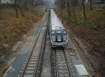 Image 137932 (478k, 1044x788) Photo by: Seth McDermott Location: Summerhill |  Image 137933 (249k, 1044x788) Photo by: Seth McDermott Location: Summerhill |  Image 138333 (277k, 1044x788) Photo by: Seth McDermott Location: Lawrence |  Image 138559 (320k, 1044x788) Photo by: Seth McDermott Location: St. Patrick |
Photos By Location
Photo locations: Downsview, Wilson, Wilson Yard, Yorkdale, Lawrence West, Glencairn, Eglinton West, St. Clair West, Dupont, Spadina, St. George, Museum, Queen's Park, St. Patrick, Osgoode, St. Andrew, Union Station, King, Queen, Dundas, College, Wellesley, Bloor-Yonge, Ellis Portal (nr. Bloor), Rosedale, Summerhill, St. Clair, Davisville Yard, Davisville, Eglinton, Lawrence, York Mills, Sheppard-Yonge, North York Centre, Finch
Page Credits
By Seth McDermott.