SkyTrain
![]()
Vancouver SkyTrain. Photo by Brian J. Cudahy, March 2003.
Overview
When Vancouver was selected to host the 1986 World's Fair, city leaders asked the Province of British Columbia for funds for an alternate form of transportation. At this time, the existing bus and roadway system was deemed incapable of handling the large crowds the fair would produce. Thus keeping with the fair's transportation theme, funds from both Victoria and the federal government in Ottawa were provided to build a state-of-the-art, inexpensive rapid transit solution, as well as replace the Cambie Street Bridge and roadways in dire need of upgrading.
The technology chosen for the rapid transit link was a mix between light and heavy rail, defined as an automated light rapid transit (ALRT) system. The driverless trains would save on labor costs, while construction would consist of modular guideway segments, as well as stations. The entire line was to be grade-separated, ending up being either elevated or underground to ensure maximum efficiency.
This first segment between Vancouver's Waterfront and the suburb of New Westminster opened in 1986, just in time for the opening of Expo 86. This world's fair was the first to feature fairgrounds separated in territory. The main fairgrounds existed on former rail yards and industrial lands around False Creek. The Canadian Government Pavilion (now known as Canada Place) was built on the downtown Vancouver Inner Harbour Waterfront northwest of False Creek. The new system, named SkyTrain, served as an important connection between these two fair areas. Some have even called the SkyTrain system a permanent exhibit left from the fair, since it enjoyed such a high profile during the event.
After the fair, the existing SkyTrain line was extended in stages east across the Fraser River to the King George Highway in Surrey. First, in 1989 between New Westminster Station and Columbia Station, not even 1 km. long, but with big fanfare. The SkyBridge was built during this same period and the extension to Scott Road Station in Surrey opened in 1990. The SkyBridge is the world's longest transit-only bridge. Finally, the expansion to King George and the completion of the Expo Line opened in 1994.
With the opening of the first branch line in 2001, the original Vancouver-Surrey SkyTrain line was color-coded blue and given the name of Expo Line. The branch line became known as the Millennium Line and is designated yellow. Both lines run duplexed over Expo Line tracks between the Waterfront terminus and the Columbia station in New Westminster.
SkyTrain is owned and operated by a subsidiary of TransLink BC, the Greater Vancouver area's mass transit authority. Most trains use TransLink's overall white with yellow and blue stripes paint scheme, but many older cars still have the old red-white-blue striped scheme of BC Transit, which operated Metro Vancouver transit service until 1998. On April 1, 1998 "Translink" took over the responsibility for transit operation.
Route Map
Track Map
Schedules and Fares
SkyTrains run so frequently, that no schedule is needed. All that is posted are the times when the first and last trains on each line leave all terminals. Don't ever worry about missing a train, as another is usually right behind it. The headways are very short.
Fares are calculated upon travel through a three zone system, and are interchangeable with SeaBus ferry and TransLink bus service, forming a seamless system. Because West Coast Express fares follow a separate fare system, SkyTrain tickets are not accepted as fare. Fares are enforced at fare control points at each station, and random sweeps through trains by fare inspectors. Should you be able to avoid fare control and be caught without fare, you'd be subject to fines and/or exclusion from system vehicles and property.
Station Design and Amenities
Most stations are elevated "island" platforms or side platform stations. Most have mezzanine levels that contain ticket machines and fare control. Each station also contains electronic readerboard signs, which indicate the incoming train's line, destination, direction, and other important service notifications. All stations, except for Granville, feature elevators. Platforms are considered "high level platforms", meaning the platform floor has been built high enough to allow it to meet the train's floor, thus making the system mostly handicapped-accessible.
Station platforms are designed to accommodate a six-car (or 3 married pairs) Mk.1 consist.
Since the SkyTrain does not use operators, the system utilizes station attendants to provide fare control, security, and information at every station. In case of emergencies, these attendants are trained to drive SkyTrains manually and provide assistance in conjunction with local law enforcement, fire, and medical response teams. Attendants are very informed about about how the rolling stock and system works, since light maintenance is also part of their duties.
Roster
Bombardier provided the first SkyTrain trainsets, now known as MK.1 cars. These cars are not articulated and operate in consist as "married pairs" (ex. car A+car B). These Mk.1 cars are also used on Detroit, Michigan's PeopleMover system and Toronto, Ontario's Scarborough Rapid Transit line (although the Scarborough Rapid Transit line is not automated, having operator cabs instead).
Also used on the Expo Line are newer, Mk.2 trains, also Bombardier products. These sleek trains were ordered for the opening of the Millennium Line, as well as to add to the capacity of the Expo Line. Unlike, Mk.1's, these trains are articulated. In fact, these trains are the longest articulated transit vehicles in service in North America. A rail system in Kuala Lumpur, Malaysia uses similar vehicles.
Both types of trains use linear induction motors (LIMs), meaning that this system not only has a typical subway third rail, but a highly visible magnetic reactor plate between the tracks. This accounts for the unique noise the train makes as it accelerates or decelerates. Trains have an engine consisting of only two moving parts, thus reducing maintenance costs. Some consider the reactor plate part of the engine.
Another unique feature of the SkyTrain system is that each car on the system has it's own name painted upon the vehicle in addition to a vehicle number. The names are derived from British Columbia cities. Example names are City of Victoria, City of Port Moody, City of Nanaimo, etc.
Trains do not carry roll signs, instead, recorded chimes and announcements indicate train direction, destination, and line.
Because a driver is not required for SkyTrain operations, a "railfan seat" is available at the ends of both types of trains. In Mk.1 trains, it folds down from the wall. The Mk.2 trains have a more comfortable seat. Be forewarned, however, because these seats are very popular and are usually occupied.
The Future
Building west from the Vancouver Community College area, the Millennium Line may someday tunnel under Broadway, reaching at least as far as Granville Street. Other plans have called for it to extend as far as the University of British Columbia, however recent official studies and plans call for a Granville terminal. This section could also be built as a light rail line or bus rapid transit all the way to UBC.
A rapid transit line south from the Vancouver Waterfront to the southern city of Richmond and the Vancouver International Airport has been proposed since the 1970's. The latest proposal, named the "Canada Line" (formerly RAV, for Richmond-Airport-Vancouver), is under construction. It consists of a north-south tunnel under downtown to Richmond, and elevated viaduct from Richmond south. A branch to the airport would break off the mainline south of Bridgeport station near the Fraser River. Planners hope to have the line ready for the 2010 Winter Olympics, to be hosted in Vancouver. The line is presently on schedule to open in 2009.
The Canada Line will not tie into the SkyTrain system directly, and will not use the same type of rolling stock. The cars for the Canada line will be fully automated and use conventional traction motors instead of SkyTrain's linear induction technology.
Another rail line under construction in Vancouver is the "Evergreen" line in the north-east section of the city, starting at Lougheed Town Center and serving the communities of Port Moody, Coquitlam, and Port Coquitlam. It has been determined that this line will operate using more "standard" light rail equipment and won't be directly connected into SkyTrain. It will be mostly constructed on the surface with a tunnel under Burnaby Mountain.
The capability to extend SkyTrain east or south from Surrey's King George terminal exists, however no official plans exist to do this yet. Currently, TransLink is looking at enhanced bus service or bus rapid transit lines in this area that would connect to King George station or Surrey Central.
Station By Station
Expo Line
Starting from Vancouver, trips originate on both Expo and Millennium Lines at Waterfront. This station is built into the historic Canadian Pacific Railway station, now a transit hub and retail space. Connections to the SeaBus ferry across the Inner Harbour to North Vancouver, TransLink rapid B-Line bus service, and West Coast Express Commuter Rail to Mission City are available here. Tracks continue east past the station to allow SkyTrains to reverse at a switch track. Passengers are not allowed on trains while switching.
This station is also connected, through underground passages, to Harbour Centre, a retail building with a popular observation tower and restaurant. CanadaPlace, Vancouver's cruise ship terminal and convention center is a short walk away.
A future rapid transit line south to the city of Richmond and Vancouver International Airport is proposed to begin at Waterfront using either conventional light rail or SkyTrain/ALRT technology.
Traveling out of Waterfront, the SkyTrain route curves around taking trains traveling west out of Waterfront to the east. During this curve, trains enter a double-decked tunnel under downtown Vancouver. This tunnel was once used to take heavy rail passenger and freight trains into the Vancouver Waterfront, but since has been converted for SkyTrain use. Trains traveling east use the upper level, those headed to Waterfront use the lower.
Burrard is the first station in the tunnel. Escalator banks and elevators take passengers up to the mezzanine level plaza on Burrard Street. From this plaza, one may enter the Bentall Centre office building complex, or take an escalator to ground level. Ticket vending machines and fare control are also encountered at this level. On the ground level, the entry plaza is covered by a glass canopy, with cherry trees surrounding it. Bus service at this station connects riders to Stanley Park to the west.
The next station, Granville, resembles Burrard, but does not have an elevator. This is the deepest station in the system, which requires a long escalator ride to the surface. The main entry to Granville is inside The Bay department store, but other buildings are connected through underground passages. Granville Street is both the main shopping area of downtown Vancouver and a bus-only transit mall. Many of Vancouver's electric trolley bus routes stop on the Granville Mall.
The SkyTrain route emerges from the downtown tunnel directly at Stadium station. This station has three platforms and a spare track to accommodate extra demand during special events at nearby BC Place Stadium. This was one of the two stations serving the main Expo 86 fairgrounds. Stadium station sits lower than street level, with glass canopies extending up the escalator banks to street level. An office building on the edge of the station area looks as if it is part of the station.
Traveling outbound from Stadium, tracks become elevated as they parallel, then duck under, the Duinsmuir Street Viaduct. Looking out the train's windows to the right (on an eastbound train), you can see what remains of the Expo 86 fairgrounds around False Creek. Land around and on the fairgrounds mostly has been developed into high-rise housing or parks. Continuing east, trains travel south, then veer east into the Main St./ScienceWorld station.
Main Street/ScienceWorld Station is typical of the modular design of stations along the Expo Line until New Westminster. This elevated "island" platform once served the main entrance to Expo 86. The fair's landmark geodesic dome, Expo Centre (a.k.a. locally as the "Golf Ball"), now houses Vancouver's science museum. A mid-rise office building called VanCity Centre was built right over the tracks to the direct west of this station.
Riders departing here can connect to Pacific Central Station, which serves ViaRail Canada trains, Amtrak's popular Cascades service (Eugene, OR to Vancouver, BC), and national bus lines. A heritage trolley line operates from ScienceWorld along False Creek to Granville Island, a popular shopping area.
The elevated line continues east to Broadway station, which has been extensively modified since Millennium Line construction. This station is slightly to the south and above of the Grandview Cut. Dug out in the last century, this open-cut allowed regular rail access to False Creek from the east.
The Millennium Line loops around from the east, meeting the Expo Line and itself again at the Commercial Drive station in the cut. This new station was connected to the existing Broadway station by a retail/office building. Access between the stations is provided by a series of escalator/elevator banks and a retail plaza between the two.
The line veers east again stopping at Nanaimo, 29th Avenue, and Joyce. This stretch of the SkyTrain line was built on or over the former BC Electric Railroad Vancouver-New Westminster interurban line's right-of-way. While grade-separated, the tracks reach ground level at 29th Avenue station, then rise as elevated again past it. A good view of the Vancouver skyline is to be had at Nanaimo station, as it is elevated atop a hill overlooking downtown.
After Joyce, trains enter the City of Burnaby, a large suburb east of Vancouver. Trains stop at Patterson, MetroTown, Royal Oak, and Edmonds. The line is elevated through this section, except for a stretch around Edmonds station, where the tracks reach ground-level.
MetroTown Station serves the core of Burnaby, and is connected by skybridge to a large retail and office complex. The station is named after the MetroTown shopping mall. A pocket track east of this station can hold an extra train if need exists.
Edmonds sits at ground-level. A large residential development was built as a "lid" over the tracks directly east of the station. Exiting this lid, trains pass by the SkyTrain yards and control center. Bombardier has set up a factory to manufacture the Mk.2 trainsets here.
SkyTrain elevates again as it curves to the northeast, following, more-or-less, the curve of the Fraser River into New Westminster. Stops in New Westminster include 22nd Street, New Westminster, and Columbia.
After New Westminster station, the tracks drop from high elevation into a below-grade alignment, taking trains into Columbia station. Columbia served as the terminus of the Expo Line until 1989, when the extension across the Fraser River into Surrey officially opened. This is an open-cut, side platform station below-grade. To the north of Columbia, two switches exist to take trains to and from the Millennium Line branch or across SkyBridge into Surrey.
From here, the Expo Line continues across the Fraser River on SkyBridge, the world's longest transit-only bridge. This cable-stayed bridge includes a third track for use in case of emergencies.
Departing SkyBridge, the SkyTrain enters the City of Surrey. The first stop is Scott Road. This station serves as a transfer point to bus service to points south. The modular construction of Surrey extension stations is essentially the same as the original stations, but with some embellishments. Some individuality was given to Scott Road, as it features green awnings.
The line moves to the southeast, as Gateway, Surrey Central, and King George stations round out the Expo Line. Surrey Central serves a large shopping mall and is a major bus service hub. Several routes converge here, feeding passengers into the SkyTrain system.
King George is the current eastern terminus of the Expo Line. From Surrey Central, SkyTrains fly over the mall parking lot, then curve east, ending at the King George Highway. Tracks continue for a bit east to allow trains to reverse at a switch. As at Waterfront station, passengers are not allowed aboard trains as they reverse direction. The Expo Line may be extended east or south from here, but so far, there are no official or unofficial plans to do so.
Millennium Line
The new Millennium line fully opened August 29th, 2001, completing a loop around the center of the Vancouver Metro Area. Tracks branch off the original "Expo Line" between the Columbia Station and the approach to the Fraser River SkyBridge. The line travels through New Westminster, northern Burnaby, and eastern Vancouver. These areas include two major shopping areas, Simon Fraser University, high-tech and industrial zones, as well as areas of projected heavy ridership and residential development in the future. The line will serve as a routing for a possible SkyTrain extension to the fast-growing cities of Port Moody, Coquitlam, and Port Coquitlam in the northeast.
The Millennium Line shares tracks between Waterfront and Columbia stations with the Expo Line. There are two points at which to transfer to the Millennium Line branch: Columbia and at the interconnected Broadway/Commercial Drive stations. For this tour, we will start at Columbia and work west to the Commercial Drive terminal. Millennium Line stations feature the first uses of individual design and public artwork on the SkyTrain system. The architecture of each station is quite impressive.
Trains from both lines use either of the side platforms at Columbia. This makes either a one-platform transfer or a cross-platform transfer possible between the two lines. Trains heading onto the Millennium Line use the eastbound platform, those continuing through to Waterfront use the westbound.
Approaching the SkyBridge, two switches for each track allow trains to access the Millennium Line. Trains move off to the side of the mainline, with the outbound tracks crossing under the SkyBridge approach. The two tracks then join and enter the New Westminster tunnel.
This tunnel takes trains under a large park, exiting onto a short ground level section. The tracks elevate, following the Fraser River. During construction, the area below the tracks was cleared and a new city park was built under the guideway. A station was planned here named Woodlands, however plans for it were dropped after a residential project nearby was canceled. Although no provisions for Woodlands station are visible, it may be built in the future.
Continuing north, the Millennium Line reaches Sapperton. This station is elevated over freight rail tracks, and is linked to street level by a walkway. A fun art feature at Sapperton is a large wheel with open panels and drawings. This is connected to an exercise bike on the mezzanine level above. If someone pedals the bike, the wheel spins, animating either phases of the moon or stick people (depending on what platform you are viewing it from).
The next station is Braid. This station currently serves as a hub for regular bus service to the northeast. It also was where trains terminated until the Millennium Line fully opened.
Out of Braid, the Millennium line curves northwest, crossing the Trans-Canada Highway, then enters Lougheed Town Centre station. The "island" station is modeled after a large Native American tent. A large bus transit hub is below the station, with a stop for the B-Line express bus service to the northeastern cities. The Lougheed shopping mall is to the northwest of the station. There are provisions at Lougheed for a future line to the northeast. The unfinished stubs are directly to the east of the station, and an unfinished side platform exists here.
The guideway generally follows the Lougheed Highway from this station, curving to the shoulders or the median of the thoroughfare. The tracks are mainly elevated through this section, but do duck to ground-level for a few short stretches.
The next station is Production Way/University, which stands out due to its wedge-shaped, wing-like roof. Riders here can connect to nearby Simon Fraser University by bus. Many television and movie production studios are located nearby, and sometimes complain about the vibrations and noise the SkyTrain makes.
Moving west, Lake City Way serves a new office/industrial park development. This station only recently opened and was still under construction well after the Millennium Line opened. As of 2003, the station is now complete.
Sperling/Lake Burnaby is located by Dairyworld, which inspires the 1960's industrial architecture of this station. A beautiful stained-glass window can be found in the station lobby.
Headed west, trains stop at Holdom, a station set in an area slated for an "urban village" development. The station design incorporates frosted glass panels which poke through the roof. At night, these panels are lit with lights that change color.
Brentwood Town Centre is the most impressive station on the Millennium Line. The station is a curved, side platform design that is completely glass-enclosed. It sits in the median of the Lougheed Highway, connected to both sides or the roadway by walkways. The Brentwood Mall, directly north, also includes a bus transit hub connected to the SkyTrain station.
The guideway leaves the Lougheed Highway here, curving south into Gilmore. The surrounding area is slated for redevelopment. A major retail/commercial complex proposed here may incorporate Gilmore station, so it is designed modularly. If plans call for any changes, then the station can be taken apart and reconfigured in the future.
The trackway snakes south and west into Vancouver city limits. From here on out, the guideway parallels BNSF tracks. The next two stations, Rupert and Renfrew are similar in design, influenced by railroad semaphores. The design of these sister stations feature an open glass design, meant to be transparent by day, illuminated at night. Both stations serve an emerging high-tech industrial area.
The elevated tracks duck down into the Grandview Railroad Cut after Renfrew station. This open cut section was built in the early 20th Century to allow train travel between the east and False Creek. SkyTrain tracks were built onto a shelf above the railroad tracks, but below the surface streets above.
At nearly the end of the Grandview Cut, the Millennium Line terminates at Commercial Drive. This station is in the cut, below the surface streets. This "island" platform is connected to the elevated Broadway station above through escalators and a new retail development. Fast food and gift shops line the space between the two stations. Although the Broadway station, built with the original Expo Line, and Commercial Drive have separate names, they form one functional station which is termed "Broadway/Commercial" on some maps. The guideway continues farther west, allowing trains to reverse. This stub will eventually contain a station for Vancouver Community College, and may be extended as far west as Granville Street should light rail not be used in this corridor. The station at Vancouver Community College is planned to open January 6, 2006.
Photo Gallery
| Five Random Images | ||||
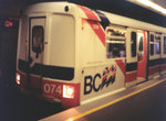 Image 22151 (138k, 1044x712) Photo by: Nathan McCartney Location: Waterfront |  Image 30643 (57k, 640x480) Photo by: Adam J. Benjamin Location: Broadway |  Image 30677 (52k, 480x360) Photo by: Adam J. Benjamin Location: Lake City Way |  Image 30688 (250k, 600x450) Photo by: Adam J. Benjamin Location: Main Street/ScienceWorld |  Image 73044 (70k, 640x480) Photo by: Oren H. Location: Waterfront |
Photos By Location
Photo locations: Waterfront, Burrard, Granville, Stadium, Main Street/ScienceWorld, Broadway, Nanaimo, 29th Avenue, Joyce, Patterson, MetroTown, Royal Oak, Edmonds, 22nd Street, New Westminster, Columbia, SkyBridge, Scott Road, Gateway, Surrey Central, King George, Woodlands, Sapperton, Braid, Lougheed Town Centre, Production Way/University, Lake City Way, Sperling/Lake Burnaby, Holdom, Brentwood Town Centre, Gilmore, Rupert, Renfrew, Commercial Drive
Links
TransLink - Greater Vancouver Transportation Authority (official site).
NW Virtual Transit Center. Unofficial transit site covering Oregon, Washington, and British Columbia.
Page Credits
By Adam J. Benjamin.