Portland Streetcar
![]()
Portland Streetcar no. 007 inbound at SW 5th/Montgomery. Photo by Peter Ehrlich, September 2009.
Overview
Portland inaugurated the new Portland Streetcar line on July 20th, 2001, making Portland the first city to build a modern streetcar system with modern vehicles in North America. Streetcars run almost entirely along paved track on city streets. The majority of the route runs along pairs of one-way streets, separated by one or sometimes two city blocks.
The system is owned and operated by the City of Portland through the oversight of the non-profit Portland Streetcar Company. Trains are operated by MAX light rail operators contracted to the streetcar system from TriMet, Portland's regional transportation authority.
History
Portland once was known for its extensive and unique streetcar system. At one time, it was one of the largest in the United States. By 1950, the last city streetcar was discontinued, with the last interurban train heading back to the car barns for good in 1959. Gasoline buses took over many of the old routes, but many people still remembered what the old system was like. Portland's city plan of 1972 called for a "circulator" system to connect close-in central city neighborhoods. It took nearly 30 years to realize this goal. In the late 1980s, these efforts culminated in the MAX line and its small-scale Vintage Trolley replicas.
In 1990, the first Citizen's Committee was formed to look at building the Portland Streetcar, and the Portland Streetcar Company was founded in 1995. Construction began in 1999 on the first 4.4 mile section between Northwest Portland and Portland State University. Revenue service began on July 20th, 2001, after three months of testing.
Projected ridership levels were set at 3,000 boardings per day. A month after opening, ridership statistics were reported at over 6,000 daily boardings, even on days with less frequent service.
Service was extended southward to the Willamette riverfront in two phases. Service began to River Place on March 11, 2005 (0.6 mile extension); and to Lowell Street on August 17, 2007 (a further 0.46 miles).
Construction began on a significant expansion to the Eastside of Portland in August 2009. This extension, along with the current line, would form a ring line around the city center, connecting Union Station, the Rose Quarter, the Lloyd District, and the Oregon Museum of Science and Industry (OMSI). The Streetcar would cross the Willamette River in two places: on the north end via the existing Broadway Bridge, and in the south on the new Tilikum Crossing Bridge (shared with MAX). Approximately 3.3 miles of new track via MLK, Grand, and Broadway would connect the bridges on the Eastside. This service opened in September, 2012.
Fares and Funding
The Portland Streetcar uses the TriMet fare system. Fares are paid by the Tap farecard or by NFT-enabled phones and credit cards by tapping at readers in the vehicles (this differs from MAX, where the readers are mounted on supports at the station platforms). Portland Streetcars, like MAX, uses the honor system, with random sweeps by TriMet fare inspectors to enforce payment. Failure to produce proof of fare may result in fines and/or exclusion form the Portland Streetcar and TriMet system.
Streetcar operations and construction are funded by the fares, an annual contribution from TriMet, a special taxation zone along the route, car and station sponsorship, and parking meter revenues. The special taxation district was created by business owners along the route whom actually volunteered and petitioned to be taxed. Although no federal funds were directly used in past Portland Streetcar projects, future projects may be able to obtain direct federal funding. Station sponsorship includes posting the the sponsoring company's name on the shelters, and when such a station is announced on board the streetcar, the sponsoring company's name is mentioned after the station name.
Plans to make the Portland Streetcar free along its entire route were opposed by Northwest Portlanders. Residents did not want to see Northwest Portland become a Park-and-Ride lot for commuters wishing to avoid paying for parking downtown.
Future Plans
A candidate for a future streetcar extension is the current route of the Willamette Shore Trolley. Formerly Southern Pacific's Red Electric interurban line, this route would again connect Portland to Lake Oswego. The Oregon Electric Railway Historical Society currently runs hourly service along these tracks using vintage vehicles. TriMet's general manager announced in June of 2001 that TriMet would pay to preserve and study the line for a future streetcar or commuter rail line. Portland Streetcar is now studying the route, which would continue south from the South Waterfront extension.
Operations
A yard underneath the elevated portion of I-405 at Sixteenth Street serves as a storage and maintenance area. If heavier maintenance needs to be done, streetcar tracks connect to MAX tracks at the intersection of Tenth and Morrison Streets (and at the Tilikum Crossing). Streetcars can use MAX tracks to travel to either the Elmonica or Ruby Junction MAX yards. While Streetcars are able to utilize the MAX system, MAX trains can not navigate a steep grade and the tight turns on the Portland Streetcar system.
Streetcars operate entirely upon city streets, except for some short stretches on the Portland State University campus. Automobiles are allowed to drive on streetcar tracks. The streetcar operators, in turn, must obey traffic signals and obey automobile traffic laws. Average speed for streetcars is about 15 MPH.
A real-time NextBus tracking system monitors streetcars in service., Most stations now feature digital readout screens displaying the time, in minutes, until the next streetcar will arrive. This information is also available online through a link on the Portland Streetcar website.
Roster
For the initiation of service, seven Škoda-Inekon Astra 10T tram cars were ordered by the City of Portland for the Portland Streetcar line. Vehicles were manufactured in Plsen, Czech Republic, then shipped to Portland via freighter. The Portland Streetcar marks Škoda's entry into the US market. The vehicles are similar in design to those in use in Europe, albeit with several noticeable differences. Most notable of which are the addition of a second cab for bidirectional use, hidden couplers, and some controls and electronics similar to those on MAX vehicles.
Each car is handicapped accessible, allowing wheelchair access by use of a "bridge plate", similar to MAX vehicles. Other ADA-compliant features are recorded system announcements and reader boards inside the vehicles which indicate an upcoming station's name and sponsor. Unlike their contemporaries in Europe and the regional MAX system, the Škoda vehicles only operate in single-car consists, since double car trains would not fit in the stations. Despite this, streetcars can be coupled together in order to tow or push disabled vehicles back to the yards.
Each streetcar is painted in a combination of two of the following colors: teal, blue, red, and orange. The sides of the vehicle are painted in different colors wrapping around each cab section respectively. From different angles, the same streetcar can appear to be two different solid colors. The colors reflect the four street grid quadrants of the city of Portland (Northwest, Southwest, Northeast, and Southeast). The sky blue exterior molding symbolizes the Willamette River.
For the 2009 expansion to the South Waterfront area, three new cars were ordered. The partnership between Škoda and Inekon had dissolved, so these new cars, numbers 008-010, were built in Ostrava, Czech Republic, by a partnership between Inkeon and the Ostrava transit agency (Dopravní Podnik Ostrava). The new cars are called model 12T, a variation of the 10T with mostly common parts.
For the 2012 Eastside expansion, six additional cars were ordered from United Streetcar, a venture including Oregon Iron Works in Clackamas with design licensing from Škoda. A prototype car was delivered in 2009 and five production cars in 2012-2014. Three further cars were ordered from Brookville Equipment Corp. in Pennsylvania. These "Liberty" model streetcars are to be delivered beginning in 2023.
For a period in 2001-2002, two of the Portland Vintage Trolley replica cars served on the Portland Streetcar route as spares and on Sundays. Also, before the modern vehicles were acquired, the Vintage Trolleys were used to test the newly constructed streetcar trackage.
| Manufacturer/Type | Unit Numbers | Year Built | Notes | |
|---|---|---|---|---|

|
Škoda 10T | 001-005 | 2001 | |

|
Škoda 10T | 006-007 | 2002 | |

|
Inekon 12T (Trio) | 008-010 | 2006 | |

|
United Streetcar 10T3 | 015 | 2009 | Prototype, not in service |

|
United Streetcar 100 | 021-026 | 2012-2014 | |

|
Brookville Liberty | 031-033 | 2023- |
Maps
Portland Streetcar Track Map (does not include the South Waterfront or Eastside extensions to the original line)
Station by Station
The tour shall begin in Northwest Portland and work east and south to RiverPlace. Due to the use of one-way street pairs, this tour will recognize the line as a north-south, (mostly) double-tracked system. Stations that are paired will be mentioned in the following format: southbound name/northbound name.
Northwest Portland to PSU
Northwest Portland is a major upscale shopping, dining, and entertainment district. The main areas of these activities are concentrated along NW 23rd and 21st Avenues, both served by stations on the Portland Streetcar line. The rest of the immediate neighborhood is mostly residential.The Streetcar can be considered to both end and begin at the NW 23rd and Marshall terminal, as it is inside the loop section taking inbound trains onto 23rd from Northrup Street, then out onto Lovejoy Street. This section surrounds the Good Samaritan Hospital complex on three sides.
For the rest of the route through Northwest Portland, trains headed south to RiverPlace travel east on Lovejoy Street, and 23rd Avenue-bound trains travel westbound on Northrup Street. Paired stations are two blocks away from each other. The stations include NW 21st & Lovejoy/NW 21st & Northrup and NW 18th & Lovejoy/NW 18 & Northrup.
In the 1970's, Interstate 405 was built elevated between the Northwest Portland and what became the Pearl District. It roughly follows 16th Street on its way to the Fremont Bridge. The space underneath between Northrup and Lovejoy Streets was utilized as the Portland Streetcar's operations and maintenance facility. There are two maintenance buildings, each with overhead and underfloor car access, one north of Northrup, and one between Northrup and Lovejoy. Management offices are also located in the maintenance building.
The yards are connected to both the Lovejoy and Northrup tracks. Streetcars inbound to the yard usually complete a trip to NW 23rd, then enter the yards from the Lovejoy Street side. Operators often change shifts here, stopping the train on the Northrup street side and handing the train over to their reliever.
After crossing under I-405, the Streetcar route enters the Pearl District. This whole area has undergone a significant transformation since the 1990's, as the former Burlington Northern rail yards and industrial warehouses have been replaced by new condo developments. The area has become quite trendy and upscale as art galleries, hair salons, and restaurants have opened while most of the former industrial establishments have left. The Portland Streetcar route curves through this neighborhood.
RiverPlace-bound trains turn off NW Lovejoy Street and onto NW 11th Avenue to travel southbound. Northwest Portland-bound trains run north on NW 10th Avenue, turning onto NW Northrup Street.
Stations on the Lovejoy/Northrup section are NW 13th & Lovejoy/NW 14th & Northrup and NW 12th & Northrup. These stations serve the Bridgeport Brewery and Brewpub (a popular local micro-brewer) and the Pacific Northwest College of Art. New development in the Pearl, once concentrated mainly on 10th and 11th Avenues, is now building north and west around this section of the streetcar route.
The 10th and 11th Avenue sections are located through the heart of the Pearl District: NW 10th & Marshall (northbound only) was closed at the opening of the Portland Streetcar due to lack of development around it. It has since opened to serve new condo towers and a soon-to-open (as of this writing) city park. NW 11th & Johnson/NW 10th & Johnson serve the new Jameson Square park. Power poles supporting the Streetcar's overhead wires have been decorated to look like stylized, abstract art totem poles. It is also the closest station pair to Amtrak service at Union Station (about 5 blocks east).
A nearby condo development was renamed the Streetcar Lofts during its construction. A late addition to the project was a large neon sign reading "Go by Streetcar", which recalls nearby Union Station's landmark "Go by Train" sign on its clock tower.
The NW 11th & Glisan/NW 10th & Glisan and NW 11th & Everett/NW 10th & Everett station pairs serve areas of the Pearl that still contain some industrial services, although new development is more prominent.
The former North Bank Depot, used for a short time as Portland's second rail passenger station, straddles 11th Avenue at Everett Street. The buildings were designed for use as freight depots by the Spokane, Portland, And Seattle Railroad (later fully merged into Burlington Northern). Disputes over running trains into Union Station forced the SP&S and it's interurban Oregon Electric Railway (OER) to terminate service here. The buildings have since been renovated into condominiums. From here, the Portland Streetcar follows the old OER route south on 11th Avenue.
NW 11th & Couch/NW 10th & Couch serve the busy West Burnside corridor. The stops are located near both sides of Powell's City of Books, a business supporter of the Portland Streetcar line and famous Portland bookstore.
Another major redevelopment project of note is the former Henry Weinhard's Brewery. Quickly after the brewery was closed, the four block area was redeveloped into office and condo space. The former brewery house was preserved and incorporated into the complex for use as a microbrew pub.
West Burnside Street divides the Northwest Street quadrant from the Southwest. From this point on, the Portland Streetcar runs on the 11th/10th Avenue pair just west of the downtown core. This is a distinct area of downtown Portland known as the "West End", an area currently undergoing many developmental changes, with even more to come in the future. The southern section of this neighborhood is also part of Portland's Cultural District, as many of Portland's premier concert halls and museums are concentrated there. The Cultural District is also the section of the West End currently undergoing the most drastic of redevelopment in the neighborhood.
The SW 10th & Stark (northbound only) stop serves a nightclub and entertainment area. Further south are the SW 11th & Alder/SW 10th & Alder stops. Northbound Streetcars stop literally at the front door of the Galleria, the former Olds, Worthman, and King department store. This terra-cotta building has had an interesting life since the department store closed, serving first as a shopping mall, it now is under restoration and home to the Western Culinary Institute.
On the blocks immediately south, the Streetcar line passes over the MAX light rail tracks on Morrison and Yamhill Streets. The 11th Avenue crossing was the most difficult section of the Portland Streetcar system, as the tracks and overhead wires had to cross over switches, into and out of, the MAX 11th Avenue loop yards in addition to the eastbound and westbound MAX tracks.
The 10th Avenue crossing was built to allow Portland Streetcar access to the MAX tracks. A switch at Morrison Street allows this, although the streetcar must reverse onto it.
South of this crossing are the SW 11th & Taylor/Central Library station pair. The stops are on either side of the Multnomah County Central Library. These stops, along with the stops on Alder Street, are the closest transfer stations to the MAX system.
New development and the cultural district are prominent at the SW 11th & Jefferson/Art Museum stops. The Portland Art Museum sits right off the northbound platform, while the Portland Center for the Performing Arts, the Oregon Historical Society, and Arlene Schnitzer Concert Hall are a short walk across the Park Blocks. The blocks on 10th and 11th Avenues between the Art Museum station pair and the next stations, SW 11th & Clay/SW 10th & Clay either have been or are in the process of redevelopment. Two large condominium projects are under construction, while three have recently been completed. The new development juxtaposes with some of Portland's oldest churches, the oldest of which is near the Clay street southbound platforms.
After this point, southbound streetcars continue down 11th Avenue, then curve onto SW Market Street. Northbound trains curve off SW Mill Street and onto 10th Avenue. At the intersection of 10th and Market, the north and southbound tracks cross. At this junction, a switch exists to allow streetcars to operate solely as a looped system, but it is seldom used.
Before Portland State University added funds to the Portland Streetcar construction project, the system was to end on this loop, with tracks later to be extended to the university added as part of the RiverPlace extension.
As a major Oregon public university located in a dense urban environment, PSU is known for its urban planning program and being friendly to public transportation. Keeping with it's reputation, the farsighted addition of PSU funds to the Portland Streetcar project allowed the university to be served during the starting phase of the project. PSU also used the occasion to build a brand new building for its School of Urban Planning.
Tracks for the RiverPlace-bound trains run on Market Street, while northbound service runs on Mill Street due to the existing one-way street grid. The main station pair serving the campus are the SW Park & Market/SW Park & Mill platforms. These stops are directly upon the Portland Park Blocks. The tree-lined Portland Park Blocks, which run north-south between the streetcar line and Broadway, are lined with most of the important campus buildings south of Market Street. The area north of Market street is mostly lined by the historic churches or cultural institutions described above. Portions of the street grid were closed for PSU, so a small portion of Mill Street is streetcar-only.
Continuing on, the next southbound station is at SW 5th and Market Its functional northbound twin is the PSU Urban Center platform. Transfers from these stops to bus service on the Portland Transit mall on Fifth and Sixth Avenues are available here.
The alignment for the northbound tracks runs diagonally through the brick-paved plaza of the new PSU School of Urban Studies, while the southbound tracks curve onto SW 5th Avenue to meet the northbound tracks at the intersection of Fifth Avenue and Montgomery Street. A southbound-only station, SW 5th & Montgomery, is situated before the meeting of the tracks.
When the tracks join, they curve onto Montgomery Street on a single-track section. Prior to commencement of the extension to RiverPlace, this was a stub track for trains to terminate on (passenger service ended at the SW 5th and Montgomery stop). Trains used to lay over here, then continue back to Northwest Portland by reversing direction. During the initial segment's opening ceremonies, much emphasis was placed on the fact that this was a temporary terminal by public officials.
With the construction and opening of the RiverPlace extension, a single tracked section was built off the Montgomery stub, rendering it a stub no more. Although now Portland Streetcars can now continue through, Portland Vintage Trolleys are to reverse here when they run on Sundays. Technical issues with the Vintage Trolley vehicles do not allow them to use the new RiverPlace extension. However, to continue on in a Škoda vehicle, please read on...
RiverPlace, Moody, Gibbs Extensions
The single track addition to the former Montgomery stub takes trains onto Fourth Avenue. This section of single track is quite short, as it curves and splits into double tracks again at SW Harrison Street. The double tracks continue all the way to the end of the line.
The stations of the RiverPlace extension were the first (and currently only) center platform stops built on the system. Here, the route runs east-west on Harrison Street through the Portland Center Apartments. The architecture of this area is almost completely modernist, as the southernmost fringes of the downtown core were redeveloped when the large South Auditorium District Urban Renewal Area project began in the 1950's. Harrison Street was kept as a two-way street and received a landscaped median. The two stations along SW Harrison Street, SW 3rd & Harrison and SW 1st and Harrison, are built into this median.
After crossing Naito Parkway (formerly and sometimes still referred to as Front Avenue), the route descends into the RiverPlace Marina on a new road structure. The roadway and its sole station are referred to as SW Harrison Roadway. Vehicular traffic is also allowed on the structure, providing a second route down to Harbor Drive, a major access point to I-5 southbound. The roadway's grade has been referred to as too steep for the trains of the MAX system, but Portland Streetcar's Škoda vehicles can handle them perfectly.
After leaving the Harrison Roadway, trains cross SW Harbor Drive, a remnant of an old freeway of the same name that Waterfront Park replaced further to the north. The new Harrison Roadway aligns with SW River Parkway at the southernmost edge of the RiverPlace Marina development.
Streetcar tracks follow River Parkway to SW Moody Avenue. While the heart of RiverPlace is considered to be centered around the marina and hotel farther north (and accessible via stairs at the Harrison Roadway station), the southern edge boasts residential development, an office building, and a hotel. The last major undeveloped piece of the RiverPlace development is now under construction. Just across from the Strand condominium project is the location of a former terminus of the streetcar line: the SW River Parkway station.
The South Waterfront extension consists of two tracks along Moody Ave. to Meade South, where a junction connects to the Eastside extension and the Tilikum Crossing. MAX trains cross the Streetcar tracks at grade at South Waterfront/S. Moody, and then Streetcar trains and MAX trains share track across the Tilikum Crossing. Two tracks continue south on Moody Ave. to Gibbs, where the southbound track continues on Moody as far as Lowell Street. The northbound track operates on Bond Street via OHSU Plaza to Gibbs. Adjacent to Gibbs is the lower terminus for the Portland Aerial Tramway, connecting the riverront campus of OHSU with the Marquam Hill campus.
Eastside Extension
Photo Gallery
| Five Random Images | ||||
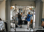 Image 52274 (179k, 1024x795) Photo by: Herman R. Silbiger |  Image 52284 (221k, 864x559) Photo by: Peter Ehrlich Location: SW Harrison/Harbor Dr. |  Image 52286 (297k, 864x574) Photo by: Peter Ehrlich Location: SW Park/Market |  Image 52294 (197k, 864x574) Photo by: Peter Ehrlich Location: NW 13th/Lovejoy |  Image 142930 (562k, 820x1220) Photo by: David Pirmann Location: Streetcar Yard |
Photo locations: NW 23rd/Marshall, NW 22nd/Lovejoy, NW 22nd/Northrup, NW 21st/Lovejoy, NW 21st/Northrup, NW 18th/Lovejoy, NW 18th/Northrup, Streetcar Yard, NW 15th/Lovejoy, NW 15th/Northrup, NW 14th/Lovejoy, NW 14th/Northrup, NW 13th/Lovejoy, NW 12th/Northrup, NW 10th/Northrup, NW 11th/Northrup, NW 10th/Marshall, NW 11th/Marshall, NW 10th/Lovejoy, NW 11th/Lovejoy, NW 10th/Kearney, NW 11th/Kearney, NW 11th/Johnson, NW 10th/Johnson, NW 10th/Hoyt, NW 11th/Hoyt, NW 11th/Glisan, NW 10th/Glisan, NW 11th/Everett, NW 10th/Everett, NW 11th/Couch, NW 10th/Couch, SW 10th/Burnside, SW 11th/Burnside, SW 11th/Harvey Milk, SW 10th/Harvey Milk, SW 11th/Alder, SW 10th/Alder, SW 10th/Harrison, SW 10th/Morrison, SW 10th/Yamhill, SW 11th/Yamhill, SW 11th Loop/Yard, Central Library, SW 11th/Taylor, SW 10th/Art Museum, SW 11th/Jefferson, SW 10th/Clay, SW 11th/Clay, SW 10th/Market, SW 10th/Mill, SW Park/Market, SW Park/Mill, SW Mill/Broadway, SW 5th/Market, Portland State Urban Center, SW 5th/Mill, SW 5th/Montgomery, SW 4th/Montgomery, Fmr. Montgomery St. Terminus, SW 4th/Harrison, SW 3rd/Harrison, SW 1st/Harrison, SW Harrison/Naito/Front, SW Harrison Roadway, SW Harrison/Harbor Dr., SW River Parkway, SW Moody/River Parkway, SW Moody/Meade, SW Moody/Gibbs, SW Moody/Curry, SW Moody/Gaines, SW Moody/Lowell, Lowell Terminal, SW Bond/Lane, SW Bond/OHSU Plaza, (Misc/Unknown), South Waterfront/S. Moody (west end of Tilikum Crossing), Tilikum Crossing, SE Water/OMSI (east end of Tilikum Crossing), SE Grand/SE Mill (Northbound), SE MLK/SE Mill (Southbound), SE Grand/SE Hawthorne (Northbound), SE MLK/SE Hawthorne (Southbound), SE Grand/SE Taylor (Northbound), SE MLK/SE Taylor (Southbound), SE Grand/SE Belmont/Morrison (Northbound), SE MLK/SE Belmont/Morrison (Southbound), SE Grand/SE Stark (Northbound), SE MLK/SE Stark (Southbound), SE Grand/E Burnside (Northbound), SE MLK/E Burnside (Southbound), SE Grand/NE Hoyt (Northbound), SE MLK/NE Hoyt (Southbound), NE Oregon/NE Grand (Southbound), NE Grand/NE Holladay (Northbound), NE 7th/NE Holladay (Southbound), NE Grand/NE Multnomah (Northbound), NE 7th/Halsey (Southbound), NE Grand/NE Broadway (Northbound), NE Weidler/NE Grand (Southbound), NE Broadway/2nd (Northbound), NE Weidler/2nd (Southbound), NE Broadway/Ross, Broadway Bridge, Lovejoy/Broadway
Links
Official Site - Portland Streetcar. Official site of the Portland Streetcar, with schedules, maps, fares, real-time arrivals, and more!
Official Site - TriMet. Tri-County Metropolitan Transit District of Oregon Schedules, real-time arrivals, and more!
Portland Streetcar - Wikipedia
Page Credits
By Adam J. Benjamin.