Portland MAX Yellow Line (Interstate)
![]()
An outbound Yellow Line train approaching Interstate Rose Quarter Station after leaving Steel Bridge. View from west bank of Willamette River. Photo by Peter Ehrlich, May 2004.
Overview
After voters approved funding for the Westside MAX extension, and noting the success of the existing Eastside MAX line, TriMet began planning a line to connect Vancouver, Washington to Clackamas County. This plan became known as North-South Light Rail. This plan would prove to be TriMet's most controversial transportation plan.
Plans hit a snag when voters in Clark County rejected funding their portion of the line in a resounding vote. TriMet then redrew the alignment as an Oregon-only plan, which resulted in two close defeats at the polls. TriMet and regional growth planners then dropped the plan and concentrated on non-light rail transportation solutions in this corridor.
Had the North-South Line been fully built, it would have stretched from Vancouver's Clark College in the north to Clackamas Town Center mall in the south. The Oregon-only version scaled the north end back to the Kenton neighborhood in North Portland.
Despite studying non-light rail solutions to transportation needs in this corridor, TriMet noticed that those living along the line in North Portland mostly had voted in favor of it. This section was to have been built on Interstate Avenue. This section of North Portland was in need of revitalization, which also caught the City of Portland's eye.
With the celebrated opening of Westside MAX and the phenomenal ridership figures coming in from this new line, TriMet decided to resurrect the Interstate Avenue portion of the North-South line and give it another go.The redefined Interstate line would begin at the Rose Quarter with the northern terminus at the Portland Expo Center. However, funding it was looking like a problem.
The City of Portland was the first to volunteer funding, as they created an urban renewal district around the corridor. This provided some funds for the line combined with TriMet. However, it was not enough for federal matching funds. Planners were still leery about going to the polls and raising taxes again, so another, creative was was found.
Since the new Airport MAX extension and the newly opened Portland Streetcar projects did not ask directly for matching funds, it was found that the entire cost of their construction could be used as matching funds. This resulted in a whopping 75% federal share in the project, and Interstate MAX, as this project became known as, was born.
While in planning, the communities along the line were invited to observe and give input to what to do with the line. Last minute changes included paved tracks along most the line, promotion and aid for businesses during construction, and further meetings. This was acceptable and TriMet broke ground at the Rose Quarter in 2001.
The entire project was an example in good management, as every goal set for construction was met. Only 3 businesses were lost due to construction, no businesses or homes were demolished for construction, and the entire project was finished 4 months ahead of schedule and $25 million under budget. Recycled materials were heavily used making this one of the nation's most greenest light rail projects.
Service began with fanfare on May 1, 2004. What may be termed Portland's biggest block party kicked off when the first train pulled out of the Rose Quarter at 11 o'clock. 23,000 people showed up to ride the Yellow Line on the first day.
The revitalization of Interstate Avenue progresses, as existing businesses obtain storefront improvement project funds from the Portland Development Commission. However, these funds are limited, as much of the Urban Renewal funds were put toward light rail construction. However housing projects and a major grocery chain store have been proposed along the line. Recently, another chain demolished their existing store and is currently building a bigger one. As this line just opened, the results of its impact will, for the most part, be forthcoming at this time.
The MAX Yellow Line is owned and operated by TriMet, the Portland Metro Area's mass transit agency.
Speaking on the success of bringing Interstate MAX to reality, TriMet's General Manager called it the "Phoenix Line" at opening ceremonies. Truly this rise from the ashes has prompted other sections of the old North-South line to be resurrected. Currently, TriMet is planning lines south into Clackamas County, one along a portion between downtown Portland and the city of Milwaukie to the south. Possibilities exist to go north into Washington State, and it is a goal of TriMet to study this over the next decade.
The Metro South Corridor Plan was born of the defeat of the North-South line to bring non-light rail transportation solutions to northern Clackamas County. However, residents of Southeast Portland were very vocal about bringing light rail back onto the table. TriMet was also looking into ways to ease congestion on the current downtown Portland MAX alignment. East Clackamas County was worried about projected growth out-pacing transportation capacity. Thus, the two phase South Corridor plan was born. Milwaukie residents, once mostly opposed to light rail, have warmed up to the new plan.
As part of the first phase, MAX would be extended from Gateway TC south to Clackamas Town Center. Tracks would be built on the downtown Portland Transit Mall from Union Station to Portland State University, branching off the mainline at the Steel Bridge. This new line would be colored Green, and Yellow Line trains would use its Transit Mall alignment.
From PSU, the second South Corridor Phase would start, taking trains across a new light rail-only bridge. Tracks would meet up with McLaughlin Blvd, following it to north of Milwaukie. Here, the tracks would loop east of downtown Milwaukie, terminating at Lake Road.
While the Green Line and Transit Mall alignments can be funded without property tax increases, it is most likely the Milwaukie segment will require a public vote on this.
A phased light rail loop is under study in Clark County, Washington. This would take the yellow line north across the Columbia River, through downtown Vancouver, then east on SR 500 to the Vancouver Mall area. Trains would then head south on I-205, crossing the Columbia and tying in with the Airport MAX/Red Line. Some maps show the loop connecting here and turning into the Portland Airport to terminate.
The Yellow Line may also one day extend farther south from Milwaukie to Oregon City, or east down the Milwaukie Expressway to Clackamas Town Center. These extensions would be far off in the future and there have not been any plans announced yet to do this.
Other plans could send a spur line down Barbur Blvd southwest into Tigard. This plan has had some study done on it, but remains unlikely at this time. No major plans for a Barbur MAX line have been announced, and local newspapers have called this a dormant proposal.
Station By Station
North-South Transit Mall
The MAX Yellow Line was recently extended into downtown Portland on a new "North-South Transit Mall" alignment.
Interstate MAX to Expo Center
Departing the Steel Bridge, the Yellow line switches off the mainline onto Interstate Avenue on a wye junction. This allows trains going back to Ruby Junction yards access to eastbound tracks or regular trains to access downtown through the mainline.
The first station, Interstate/Rose Quarter features tall glass trees, making this station a focal point. Perhaps the most striking feature of the new line, these trees are lit at night using solar energy. Both side platforms feature three "trees" each. Transfers to the Red and Blue Lines and bus service at Rose Quarter TC is a walk across the Rose Quarter lawn.
This station, like Rose Quarter TC, serves the Rose Garden Arena and Memorial Coliseum. Like most of the Interstate stations, this is located in the center of Interstate Avenue.
Continuing north, tracks are tie and ballast, ducking under the Broadway Bridge. A new major-league baseball stadium has been proposed near this location. There are good views of the Portland skyline from the left hand side of the train (facing the cab). The line continues into the Lower Albina District, now a mostly industrial area, but formerly a vibrant community famous for its nightclubs and jazz acts. The Albina/Mississippi "island" station here honors that heritage with a large musically-themed sculpture. This station also serves a popular brewery and restaurant, and Emanuel Hospital. Some of the old buildings lining the route are being restored.
The tracks through Albina are paved, but return to ballast shortly after crossing Russell Street. Continuing north, trains climb the "Interstate Hill" after crossing under the I-405 Fremont Bridge. The Union Pacific Albina Yards can be seen to the left. After cresting the Interstate Hill, the paved tracks begin again. The next station is Overlook Park, which sits in front of the Kaiser Permanente Interstate Clinic complex. The theme of this station focuses on healing and the community. Lighted kiosks are also a tribute to the neighborhood's traditional Polish heritage.
North of Overlook Park, the rider experiences the first of Interstate Avenue's roadside Americana architecture. The Alabi Pub and the Palms Motor Hotel once catered to the motorists when Interstate Avenue was the highway north to Vancouver. Colorful neon signs such as these two businesses' still light up the night after many decades. Both businesses have been doing well as of this writing.
The tracks and Interstate Avenue jog to the west, then continue heading north around Skidmore Street. At the end of this curb, the "island" platform of N. Prescott Street serves Going Street and Swan Island. A unique rainwater runoff system turns a sculpted "prow" into a fountain, then sends the water into a nearby greenspace. A large one-ton propeller-shaped sculpture sits nearby.
The next three Yellow Line stations resemble Eastside MAX stations along East Burnside in layout. However, these new stations include artwork instead of the "cookie-cutter" look of the original MAX line. The first is colorful N. Killingsworth Street. The design of the station was influenced by the artwork of Africa and India.
Rosa Parks (N. Portland Blvd.), the next stop, features Native American design in its railings, shelter pillars, and platform paving. Bus service at this station connects to the University of Portland.
N. Lombard Transit Center serves as a connection point to bus service across north and northeast Portland. Since the Yellow Line replaced the old #5-Interstate bus, the #6-MLK has been rerouted here to connect to TriMet bus service to Vancouver, WA. Previously, this service was provided by #5. Artwork here features mosaic tiled pictures. Images reflect on workers. The station shelter pillars were given tilework, which is duplicated on the Lombard Street bus shelters.
To the north, the tracks jog west again, following Interstate Avenue into the Kenton neighborhood. The northbound lanes of Interstate Avenue cross the tracks just before Kenton/N. Denver station. Set at the intersection of Argyle, Interstate, and Denver Avenues, this is the last station on Interstate Avenue. A huge statue of Paul Bunyan looks over the intersection, a local landmark predating the MAX line.
Pulling out of Kenton, trains move onto the Vanport Bridge after crossing Argyle Avenue. Previously known as the "Long Bridge", this structure spans the Columbia Slough, taking trains into Delta Park. Mirrored balls with flaming tails are affixed to the bridge's railings, recalling old cars or hot rods. As trains progress north, blue panels symbolizing the Columbia River intermix with the flames, thus appearing as if the flames are being put out by water. To the left, you are able to see right into the Portland International Raceway.
Directly after the Vanport Bridge is the Delta Park/Vanport Transit Center, so named to commemorate the World War 2-era prefab housing city which once existed here. In 1948, the Columbia River flooded the city, then the second largest in Oregon, thus destroying it and displacing thousands. Delta Park is actually two large parks divided by the I-5 freeway. West Delta Park and the Portland International Raceway sit atop the site of Vanport. The MAX station is elevated to accommodate the descent of the Vanport Bridge. It sits between the I-5 freeway and Expo Road, allowing direct access bus ramps to be built into the station. Thus far, these are unused. A large park and ride lot was built at this station.
While constructing Interstate MAX, contractors moved land excavated at the Rose Quarter to fill sections at Delta Park. They also built several new large wetlands, which you can see to the left. Tracks parallel Expo Road into the Portland Expo Center grounds.
Expo Center station marks the end of the line for now. The tracks and electrification end directly inside the station. However, this station is designed to allow the Yellow Line to easily be extended north. This station has two main tracks, and an "island" platform. A pocked track and spare side platform were built for use during special events.
The artwork here addresses the Japanese-American relocation center that operated here during World War 2. Three large Japanese gates feature dangling metal tags, similar to those internees used on their luggage.
Downtown Vancouver, Washington is only a mile away from the end of the tracks. The abrupt end of tracks reminds me of the terminus of a San Diego Trolley line, which posted an interesting sign at the end of the tracks. I'll close with it's statement, appropriate for the Yellow Line: "To be Continued....."
Photo Gallery
| Five Random Images | ||||
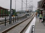 Image 29581 (80k, 480x360) Photo by: Adam J. Benjamin Location: Delta Park/Vanport Transit Center |  Image 29593 (243k, 640x480) Photo by: Adam J. Benjamin Location: Interstate/Rose Quarter |  Image 32819 (176k, 720x478) Photo by: Peter Ehrlich Location: Expo Center | 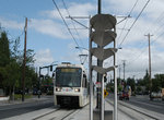 Image 51314 (186k, 864x574) Photo by: Peter Ehrlich Location: N. Interstate/Prescott |  Image 106074 (181k, 930x618) Photo by: Peter Ehrlich Location: Steel Bridge |
Photos By Location
Photo locations: Expo Center, Delta Park/Vanport Transit Center, Vanport Bridge, Kenton/N. Denver, N. Interstate/Lombard Transit Center, N. Interstate/Rosa Parks Way, N. Interstate/Killingsworth, N. Interstate/Prescott, N. Interstate/Maryland Ave., N. Interstate/Shaver Ave., N. Interstate/Failing Ave., Overlook Park, Albina/N. Mississippi, MAX Interstate Line at Broadway Bridge, Interstate/Rose Quarter, Interstate Jct., Steel Bridge, Union Station Area, NW 5th/Glisan Street (Union Station) (SB), NW 5th/Davis (SB), NW 5th/Couch Street (SB), 5th/Burnside, SW 5th/Oak Street (SB), SW 5th/Stark, SW 5th/Washington, SW 5th/Morrison, SW 5th (Pioneer Place) (SB), SW 5th/Yamhill (SB), SW 5th/Taylor (SB), SW 5th/Salmon (SB), SW 5th/Main (SB), SW 5th/Madison (SB), SW 5th/Jefferson Street (City Hall) (SB), SW 5th/Columbia (SB), SW 5th/Clay (SB), SW 5th/Market (SB), SW 5th/Mill Street (PSU Urban Center) (SB), SW 5th/Montgomery (SB), SW 5th/Harrison (SB), SW 5th/Hall (SB), SW 5th/College (SB), SW 5th/Jackson (SB), Jackson Loop, SW 5th (PSU South) (SB), SW 6th (PSU South) (NB), SW 6th/College (NB), SW 6th/Montgomery Street (PSU Urban Center) (NB), SW 6th/Mill (NB), SW 6th/Salmon (NB), SW 6th/Madison Street (NB), SW 6th (Pioneer Courthouse) (NB), SW 6h/Washington (NB), SW 6th/Oak (NB), SW 6th/Pine Street (NB), SW 6th/Burnside (NB), NW 6th/Davis Street (NB), NW 6th/Hoyt Street (Union Station) (NB), South Waterfront/SW Moody, Tilikum Crossing, OMSI/SE Water, Clinton/SE 12th, SE 17th/Rhine, SE 17th/Holgate, SE Bybee, SE Tacoma/Johnson Creek, Milwaukie/Main, SE Park
Page Credits
By Adam J. Benjamin.