Portland MAX Blue Line (East-West)
![]()
Inbound Type 2 car no. 204 at Rose Quarter. Photo by Peter Ehrlich, June 2006.
Overview
Eastside MAX
The origins of MAX light rail begin in Portland's old trolley systems. TriMet, the Portland Metro Area's transit authority, is a direct descendant of Portland's once-extensive trolley system.
The last city lines were closed in 1950, and a long-running Portland-Oregon City interurban line ended service in 1958. Despite efforts in the past to save the streetcars, Portland converted to all-gas bus service run by Rose City Transit.
By the 1960's and 1970's, Portland was violating federal clean-air standards on a daily basis. Concurrently, a controversial new freeway was in the planning stages. The Mt. Hood Freeway would have sliced through Southeast Portland, displacing thousands. Grass-roots efforts around the city called attention to the general distaste for new freeways, and affected local elections. These efforts culminated in the election of anti-freeway politicians to city and county offices. These new administrations successfully lobbied and killed the Mt. Hood Freeway.
About this time, The Tri-County Metropolitan Transportation District (popularly TriMet) was also created by the city of Portland, using special powers granted by the state legislature. Rose City Transit was not doing enough to generate ridership and meet federal air quality standards. When Rose City asked the city for a fare increase, the city created TriMet. After lengthy debate and lawsuits, and a transit worker's strike, TriMet assumed all operations of Rose City Transit in December of 1969. They quickly absorbed many of the outlaying suburban bus services over the next few years. TriMet also began planning for rapid transit solutions, opening the Portland Transit Mall to buses in 1975, and studying light rail.
After the decision was made to scrap the Mt. Hood Freeway in the 1970's, light rail in Portland went to the forefront of plans to improve Portland Metro Area traffic problems. Momentum was boosted when legislation was passed in the US Congress to allow funds from canceled freeway projects to be used for urban transit projects. Voters approved funding to build what was then called the Banfield Light Rail Project, named for the freeway (I-84) which the alignment mostly followed.
Despite strong support in Portland for the project, Gresham officials and businesses were cold to the proposal. A Gresham City Council vote to sign on to the project won by a single vote. Had this gone the other way, the line would have ended near Gresham's city limits (at about 162nd Avenue).
Despite the approval, Gresham City Council pushed for (and got) light rail to veer away from the traditional downtown area of Gresham. Civic leaders and businesses were fearful that the trains would bring more crime and the undesirable types associated with it. These fears proved to be unfounded as light rail brought attention and riders to areas around the Gresham alignment. Property values rose and none of the rampant crime that was expected materialized. Gresham has since relocated its city hall to near the MAX line, and retail and residential developments have followed.
Construction began on the 15 mile starter line in 1981, with service beginning in 1986. The system was named MAX, short for Metropolitan Area Express, in a local contest.
Along Portland's section of Eastside MAX, property values raised and development has continued to this day. This increase in development and housing density prompted the next expansion: taking MAX west into Beaverton and fast-growing Washington County.
Westside MAX
The redevelopment and transit ridership figures from the Eastside line provided the impetus to extend MAX further west into Washington County. In 1992, voters approved the local matching funds to build the line. At first, the line was to end in Beaverton, but was farsightedly extended to Hillsboro during the planning process.
Construction on this 18 mile line began in 1994, opening fully in September 1998. Within 19 months, Westside MAX broke its projected 2005 ridership estimates. Other ridership figures showed a huge jump in transit use along the Westside Line, with the most trips coming from riders new to transit.
Unlike Eastside MAX, Westside MAX was built through mostly undeveloped areas. Even before the line opened, many new residential and retail projects sprang up along the line, especially in the mid-Washington County section. High tech businesses attracted riders, as two MAX stations serve close to to Intel Plants.
Inside Hillsboro and Beaverton, the cities redeveloped areas around major stations. Beaverton's Round project and the Hillsboro Civic Center are two examples of these cities attempting to redefine themselves.
According to Metro Area long-range transportation plans, Westside MAX may one day be extended west from Hillsboro into the city of Forest Grove. Bus rapid transit or commuter rail technology also could be considered for this link.
Another extension is mentioned in a May 2004 Oregonian newspaper article. This would extend Eastside MAX from the current Cleveland Avenue terminus station to Mt. Hood Community College. The college is just to the northeast of the current line. This extension would not only serve MHCC students, but also residents of the nearby City of Troutdale.
Station-by-Station
Eastside MAX
The route through Gresham follows an old electric interurban right-of-way, once known as the Mt. Hood Railway. This section was originally single-tracked to Ruby Junction. Increased ridership figures in the 1990's merited double tracking, especially after the Westside line opened. Tracks are tie-and-ballast style and continue in this form until the Lloyd District.
Service begins at Cleveland Avenue, a large park and ride station. Tracks and electrification continue east to allow for the storage of a two car train on each track. To turn trains around, the operator simply switches cabs here. A double crossover switch exists to the direct west of the station to allow access to both tracks for incoming trains.
Moving west, the next stop is Gresham Central Transit Center. This station received a sculptured living room set in 2001 as part of public art program. Bus service connects to points in eastern Multnomah County and Portland. A park and ride garage here includes a ground-floor retail level.
Gresham City Hall is another park and ride station, and is host to the new Gresham seat of government. The new city hall is just off the westbound platform. The east end of the new Gresham Station retail development is served here.
Civic Neighborhood is an unfinished station awaiting the build-out of Gresham's mixed-use Civic Neighborhood Project. TriMet ties development of stations into the development of the surrounding area. Currently, trains do not stop here and the platforms remain fenced off. From here, the tracks enter into an open cut nicknamed "the Trench" by MAX operators.
As trains emerge from "the Trench", riders pass the Ruby Junction Rail Control and Operations Facility. First built for the original alignment, this facility was significantly expanded during Interstate MAX construction. Ruby Junction is also the dispatch center for the all of TriMet's bus and MAX operations.
The East Burnside section begins at the Ruby Junction/E 197th station. This station serves the Ruby Junction Yards and is often the point where MAX operators switch shifts, or trains returning to the yards terminate, according to their roll signs.
This long stretch travels down the center of East Burnside Street, also once part of the former Mt. Hood line. This section has seen many residential projects pop up around the MAX line, but is mostly single-family homes.
Other stations are located at Rockwood Transit Center-E. 188th, E. 181st, E. 172nd, E. 162nd, E. 148th, E. 122nd, and E. 102nd. Including Ruby Junction, these stations are staggered side platforms, sitting on either side of the cross street. These stations look very similar in appearance.
West of E 102nd Avenue, Burnside Street meets I-205, and the MAX tracks curve north. The tracks follow the shoulder of I-205, ducking under Glisan Street to enter Gateway/NE 99th Ave Transit Center. This station is one of the most heavily used on the entire system. Gateway's Park and Ride lot fills up rapidly in the morning. The MAX Red Line also joins the Blue Line south of Gateway TC. Another branch off the Eastside MAX segment will continue south on I-205 from here. It will be known as the Green Line.
Gateway has three tracks and platforms. The westbound platform is used only by Blue Line trains. The center platform is shared between the eastbound Blue and Red Lines. The eastbound platform is where one transfers to the Airport-Bound Red line trains. The entire platform area is surrounded by bus stops. These lines serve east and outer northeast Portland.
Gateway was the first Eastside MAX station to receive public artwork. Three feather wind vanes were installed as part of the Airport MAX public art project.
The layout may be confusing, as Gateway is oriented north to south. Trains going west head north while Airport and eastbound trains move south.
When trains continue west from Gateway, they head north, then veer to the east as they cross the I-205/I-84 interchange flyover bridge. This takes trains onto the north shoulder of the I-84 Banfield Freeway. Tracks are located between the Union Pacific Mainline and the freeway as the route meanders through Sullivan's Gulch.
MAX trains reach the highest speeds on the system through this section. Three "island" stations serve this section, connected to the streets above by stairs and elevators: NE 82nd, NE 60th, and Hollywood/NE 42nd Transit Center. All are similar, however Hollywood contains a pedestrian bridge across I-84 and bus bays to the north.
From inside Sullivan's Gulch, tracks rise into the Lloyd District. Often considered an extension of downtown, the Lloyd District contains several large office buildings. Tracks run along NE Holliday Street on paved tracks. Stops become closer together to serve the offices and attractions through Portland's city center. This also marks the beginning of Portland's Fareless Square, a ride-free zone covering the downtown core of Portland.
Lloyd Center/NE 11th serves the popular Lloyd Center Mall. The shopping center is a one block walk across Holliday Park to the north. There is a short spur track here that takes the Portland Vintage Trolley into the trolley-only Doubletree Hotel station. When not in use for the trolley, TriMet uses this siding for storage and for reversing some trains terminating at the Rose Quarter.
NE 7th Avenue serves the the large complex of state government and other office buildings nearby.
Convention Center serves the Oregon Convention Center. The twin spired building was built in this location specifically because the MAX line was routed here. The building's main entry faces the light rail station instead of a parking lot.
One block to the west of the Convention Center stop, the Rose Quarter Transit Center is the last station on the east side of the Willamette River. It is located underneath the I-5 overpass. This area also houses car barns for the Portland Vintage Trolley.
The Rose Quarter is the premier entertainment and sports venue in Portland. The complex includes the Rose Garden Arena, Memorial Coliseum, and retail space. These events generate large crowds on MAX trains and buses through here. The layout utilizes two side platforms, and a pocket island platform and track for train storage. Recently, retractable fences were installed on the platforms for crowd control.
Bus service through this station connects into downtown and North Portland. The new Yellow Line stops at the Interstate/Rose Quarter station on the other side of the complex. Riders transferring to the Yellow Line here can either walk 200 yards or stay aboard and transfer at the next station west.
Trains cross the Willamette River at the Steel Bridge. This unique vertical-lift drawbridge has two decks which may be lifted independently of each other. This may be the only kind of bridge of this type in the world. MAX trains use the top deck's center lanes. The westbound lane was converted to exclusive bus/LRT use recently. However, eastbound auto traffic is still allowed to drive over the MAX tracks, the only section of the line where this is allowed.
Other than MAX, Oregon Department of Transportation leases the top section of the bridge as part of the State Highway system (Union Pacific owns he bridge). The lower deck contains two tracks for the Union Pacific mainline and Amtrak use. A recent retrofit added an outer bike lane to the lower deck to connect Waterfront Park to the new Eastbank Esplanade. The view can get pretty interesting when there are two types of trains using the bridge at once!
Downtown/Transit Mall
Trains descend from the Steel Bridge south onto SW First Avenue. This street served as the site of Portland's very first horse-drawn streetcar line in 1890. Many of Portland's oldest buildings line the route, providing an interesting streetscape when juxtaposed with the modern light rail vehicles and taller buildings on the skyline. Tracks through this section, downtown Portland, and Goose hollow are paved with Belgian blocks, further enhancing this experience. Stations in this segment are side platforms built into the sidewalks.
The first station, Old Town/Chinatown serves a redeveloping area adjacent to the trendy Pearl District. Although not the historic location of Chinatown, this area is now how to the beautiful Classical Chinese Gardens and many Chinese restaurants. Portland's Union Station and the Greyhound depot are nearby, about a 7 block walk.
Skidmore Fountain serves the popular Portland Saturday Market and Tom McCall Waterfront Park. This station was built under the west end of the Burnside Bridge and is connected to a bus stop above by stairs. MAX trains pass right in front of the station's namesake fountain, which dates back to the 1870's.
Oak/SW 1st sits near offices and art galleries. south of this station, tracks dip under the Morrison Bridge. A crossover track exists at the trough of the underpass, making a switch at this location difficult, but possible. This switch is sometimes used when MAX service is closed through downtown for parades.
Directly after emerging from beneath the Morrison Bridge, the tracks split at SW Morrison Street. The tracks continue west separately on Yamhill and Morrison Streets. Eastbound trains use SW Yamhill, westbound trains use SW Morrison. Platforms along both streets are paired, but named differently. Functionally, the westbound and eastbound platforms are one station. However, Rail Control, Local Law enforcement, and medical teams want specific names for each platform location, as not to confuse responders.
Each station is built into the sidewalk of the street. tracks were laid on the separate streets in order to provide a lane of auto access and limited parking through the Yamhill/Morrison corridor. The stations (moving from east to west, Yamhill platform-Morrison platform):
Yamhill District and Morrison/SW 3rd are near the historic heart of Portland, but have seen light rail bring in two new modern office buildings on Morrison Street. the curving Yamhill District platform takes up the entire width of Yamhill Street in order to make a tight turn onto SW First.
Mall/SW 4th and Mall/SW 5th serves the Pioneer Place Mall, shopping areas, and the Portland Transit Mall's southbound lines on Fifth Avenue.
Pioneer Square North and Pioneer Square South, are announced as Pioneer Courthouse Square in both directions aboard trains. The postmodern city square is the focal point of downtown Portland. TriMet's ticket office and a visitor's information center is located beneath the waterfalls under Starbuck's. The Fox Tower, a recently completed 22-story office building, sits across Broadway. Riders may also connect to the Portland Transit Mall's northbound lines on Sixth Avenue.
Library/SW 9th and Galleria/SW 10th are platforms on both sides of the Galleria's parking garage. These stations take their name from surrounding buildings. The Galleria building, is an old department store that now hosts the Western Culinary Institute. Library refers to the Multnomah County Central Library, which sits on the corner opposite the MAX station. Riders wishing to connect to the Portland Streetcar may transfer here on Tenth and Eleventh Avenues.
If an westbound train's roll sign ever states that it terminates in the "City Center", it means that the Galleria is the last stop. Shortly after this station, a looped yard allows trains not continuing west to lay over, or light maintenance to be performed. The 11th Avenue yard has three tracks and is now used by the Portland Vintage Trolley and Yellow Line MAX trains. This ends the original Eastside MAX alignment. Trains running on the full Blue and Red Line routes continue through to the Westside MAX alignment.
Westside MAX
As part of Westside MAX, the Yamhill/Morrison tracks were extended west from the Eastside MAX alignment to merge again at SW 18th street, tracks then continue through the Goose Hollow neighborhood.
Crossing over I-405, trains leave Portland's Fareless Square and end up at the first station, PGE Park. Although this station has Yamhill and Morrison street platforms, the station managed to get away with having one name. The westbound platform contains a pocket track and side platform for special events.
The station was named after the nearby baseball stadium, formerly known as Civic Stadium. When the name of the ballpark changed, so did the station's name. Regardless, many Portlanders still refer to both this stop and the ball park by that name.
The two tracks merge, moving south on SW 18th Street, stopping a block away at Kings Hill/SW Salmon. This island platform sometimes is closed during big events at PGE Park, but serves Lincoln High School and the Multnomah Athletic Club. Near this station, "Simpsons" creator and Lincoln High graduate Matt Groening drew Bart Simpson into the concrete sidewalk along 18th for the Westside MAX art team.
Tracks curve west through the intersection of 18th and Jefferson St. This forms a roundabout, of sorts, for auto traffic called Collins Circle. Trains pass trough a slice of the circle. Directly after Collins Circle is the Goose Hollow/SW Jefferson station. Former Portland Mayor Bud Clark, a big supporter of Light Rail, owns the Goose Hollow Inn tavern across the street from the station. After stopping at Goose Hollow, trains follow Jefferson Street west, pass under the Vista Bridge, and descend into the Robertson Tunnel portal.
This three mile long tunnel consists of three interconnected tubes: two for tracks in each direction, and an emergency/access tube. This was the most difficult part of the 1998 Westside MAX project. Dug by boring the tubes from both ends and meeting in the middle, the project suffered setbacks when the eastern side drilling team experienced tougher rock to drill through.
The tunnel's only station, and the closest thing Portland has to a subway, is Washington Park. This station serves the popular Oregon Zoo, Children's Museum, World Forestry Center, and International Rose Test Gardens above. At 260 feet below the surface, Washington Park station is the deepest transit station in North America, and the second deepest in the world (Moscow, Russia has the deepest).
Four high speed elevators connect the MAX station to the surface. The elevator trip up or down takes less than 5 minutes. What "floor" the elevator car is on is displayed as feet above sea level. Indicators both at the surface and in the tunnel display the elevator's progress as moving through time, based upon the type of soil the elevator shafts were dig through.
Artwork above and below utilizes drill core samples taken before construction began. One sample is enclosed in a tube along the platform walls, displayed as a timeline of geologic history. On the surface, a circular sample from the tunnel boring machine is on display.
Also interesting is that year round, the station remains at an average temperature of 50 degrees Fahrenheit. Although over a mile away from the nearest portals, trains can be heard at the station as soon as they enter the tunnel. When a train approaches, it pushes a gust of cold wind ahead of it.
Trains exit the Robertson Tunnel in the west near Golf Creek. A spare pocket track exists here to allow for train storage or for trains to "terminate" at Washington Park station for special events.
Continuing west, tracks parallel the busy US Highway 26, also known as the Sunset Highway. After crossing an overpass, then an underpass, trains enter the Sunset Transit Center, an open-cut, side platform station below grade. Stairs and elevators connect the platforms to the bus bays, parking garage, and a skybridge above. The transit center is laid out to mimic the rays of the sun.
Trains directly enter a 600 ft. "horseshoe" tunnel, so named as it takes tracks under Hwy. 26 in nearly a half-circle. Emerging from this portal, the tracks run parallel to Oregon Hwy. 217 into Beaverton. At about the Canyon Road exit, tracks move southwest into Beaverton Transit Center.
This station serves as a hub for bus service, as well as the terminus for the MAX Red Line. A glass clock tower pavilion surrounded by bus bays directly to the south. A future commuter rail line south to Wilsonville will terminate on the other side of the center pavilion. Airport MAX trains terminate on the center "pocket" track and those boarding or deboarding the Red Line access trains on the center platform. The transit center is also connected to a neighboring shopping center.
The next station is Beaverton Central, set in a new development known as The Round at Beaverton Central. The development consists of office and condo buildings set in a large circular plaza around the MAX station. Construction on The Round began in 1998, but sat unfinished due to the bankruptcy of the developers. Thankfully, the City of Beaverton stepped in and arranged for the project to be completed. The first phase was opened in 2002. While this project sat dormant, the MAX station was open, but fenced in, to serve Cedar Hills Blvd. to the west.
Here, the Westside MAX line begins to follow the old Oregon Electric Railroad's former Portland-Forrest Grove interurban line right-of-way. This old rail route is followed for the rest of the route. Millikan Way is the next stop, set in wetlands and the Tektronix Campus. This station also serves many office parks, some of which link themselves to the MAX station by shuttle bus. This station's artwork reflects the mixing of nature with high technology.
Beaverton Creek is located near newly developed apartment communities and office parks. Woods directly to the north separate the Nike World Campus from the station. A heavy rail spur here was retained to serve light industrial customers and bring new MAX vehicles delivered by rail into the Elmonica yards. The spur line runs parallel to the MAX station, so riders must cross these tracks to access the station.
Merlo Road/SW 158th provides a connection to the Tualatin Hills Nature Park. TriMet's Merlo Bus Garage is located directly south of the station. The ramp that is used to bring MAX cars off flatbed rail cars can be seen to the east of here.
The next station, Elmonica/SW 170th, is named after a stop on the old OER route. This station serves a park and ride lot and new apartment developments. The history of this stop is reflected in the station's artwork. This station is named after an old OER stop here. The Elmonica Maintenance Facility is directly east of the station. This facility is the Westside maintenance and storage equivalent of the Ruby Junction Yards.
Willow Creek/SW 185th Transit Center is set among cherry trees and pink stone benches. Artwork reflects a theme of literacy, as Washington County's library system was supposed to build a new library here. Unfortunately, the plans did not materialize. Instead a large new apartment community has sprang up around the Park and Ride lot.
Willow Creek was initially going to be the end of the Westside line in early plans. However, the population growth of Washington County and the expansion of high-tech employers into the area prompted the inclusion of Hillsboro into the project.
185th Avenue marks the boundary between Hillsboro and Beaverton, however the land between the two cities was mostly undeveloped at the time Westside MAX was in planning. However, big-name high tech companies, such as Intel, had all ready built large manufacturing plants in the area. This earned the area the nickname of the "Silicon Forest", and provided the impetus to take the Westside line into Hillsboro proper.
The first station, Quatama/NW 205th, prompted the rapid development of the areas surrounding the station. Artwork here refers to wetlands, the most visible pieces being several large cattails, and a unique rainwater drainage sculpture.
Orenco/NW 231st also prompted a large building boom, as it sits near to Intel's Rondler Acres Plant. This area previously had been based a small town by the name of Orenco, but is now applied to the area north of the station as well. The award-winning Orenco Station, a mixed-use development, is mostly built-out. Office complexes have also sprouted up around the Rondler Acres and Orenco station sites.
Hawthorn Farm to the west is named after the Intel Plant directly north of the station. The artwork at this station is quite impressive, as the features interact with incoming trains. Chimes will play and the sound of a train wooshing by is broadcast as a train nears.
The Washington County Fair Complex is directly served at the Fair Complex/Hillsboro Airport station. The Port of Portland Hillsboro Airport is a walk across the fairgrounds, which is a large city park when the fair is over. There are large crowds here in the summer months, as the fair and the Rose Festival Air Show attract many people to the events. A "pocket" track is located to the west for extra train storage. A large trophy structure on the platform reads "World's Best", symbolizing competition and sportsmanship.
Trains enter Hillsboro proper over the Main Street Bridge. This unique arch bridge breaks traditional overpass construction techniques and provides an unique gateway into the city. The Golden Spike for the Westside line was laid on the bridge in 1998.
Tracks continue into Hillsboro starting at the Washington/SE 12th Avenue station. This side platform station is almost southwestern in theme, featuring mosaic tiled walls and benches. Each tile on the westbound platform wall was designed by members of the community.
The tie-and-ballast tracks change to red-brick paved tracks shortly west of this station, as they continue in the median of Washington Street. Automobile traffic is only allowed to access the tracks to make left turns into driveways. Tuality Hospital/SE 8th station is an island station in the median. The station features an uplifting theme of health and healing. This is symbolized by metal doves paved into the platform and plants used in traditional healing. Employees at Tuality Community Hospital, 1 block to the south, frequently use this station.
Trains enter the downtown core of Hillsboro, stopping at the Hillsboro Central/SE 3rd Transit Center. This station sits directly on the site of the old Oregon Electric station that once served Hillsboro. History plays an important role in the theme of this station, as it looks just like an old railroad station. Artwork reflects the agricultural past and high tech future of Hillsboro.
Tracks continue west, then veer to the north at Adams Street. A switch before the curves allows trains to access Hatfield Government Center, the western Blue Line terminus. A large park and ride garage was built to serve commuters. The area around this station is developing into a large complex of civic and county offices. Washington County Sheriff's offices, the county jail, courthouse, and other offices are nearby. Hillsboro has begun a large civic center project, relocating offices nearer to Washington Street. Unlike the east end of the line, tracks directly end inside this station. There are three tracks and platforms for trains. The center platform is currently the only active platform. It is unclear how this station would be configured in the event of a possible extension further west to Forest Grove. Trains lay over to give operators time to take a break and keep the timetable. Once ready to go, the operator switches to the front cab, programs the route into the trip computer, and takes off back to Gresham.
Photo Gallery
| Five Random Images | ||||
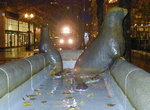 Image 18543 (85k, 640x480) Photo by: Adam J. Benjamin Location: SW 5th/Mall | 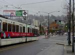 Image 29622 (58k, 640x480) Photo by: Adam J. Benjamin Location: SW Salmon/Kings Hill |  Image 51342 (204k, 864x594) Photo by: Peter Ehrlich Location: Beaverton Creek |  Image 105723 (218k, 930x618) Photo by: Peter Ehrlich Location: Rose Quarter |  Image 105738 (279k, 930x618) Photo by: Peter Ehrlich Location: SW 6th/Yamhill |
Photos By Location
Photo locations: Cleveland Avenue, Gresham Central Transit Center, Gresham City Hall, Main St.-Gresham, Civic Neighborhood, NW Wallula Overpass, E 197th/Ruby Junction, Ruby Junciton Maint. Facility, E Burnside/SE Stark, E 188th Transit Center/Rockwood, E 181st, E 172nd, E 162nd, E 148th, E 122nd, E 102nd, NE 99th/Gateway Transit Center, NE 82nd, NE 60th, NE 42nd/Hollywood Transit Center, Between Hollywood TC and Lloyd Center, NE 11th/Lloyd Center, NE 9th/Holladay, NE Holladay/NE 7th, NE 7th, Broadway/Morrison, Convention Center, NE Holladay/NE 3rd, NE Holladay/NE 2nd, Rose Quarter, Interstate Jct. (Blue/Red Lines), Steel Bridge, NW 1st/Couch, Old Town-Chinatown, NW 1st/Davis, Skidmore Fountain, SW 1st/Oak, SW 1st/Stark, SW 1st/Pine, SW 1st/Ash, SW 1st/Ankeny, Morrison Bridge, Yamhill District, SW 2nd/Morrison, SW 3rd/Morrison, SW 3rd/Yamhill, SW 4th/Mall, SW 4th/Yamhill, SW 5th/Mall, SW 5th/Yamhill, SW 6th/Yamhill, SW 6th/Morrison, Pioneer Square North, Pioneer Square South, SW Park/Morrison, SW 8th/Yamhill, SW 9th/Yamhill, SW 9th/Library, SW 10th/Galleria, SW 10th/Yamhill, SW 10th/Morrison, SW 9th/Morrison, SW 11th/Morrison, SW 11th/Yamhill, SW 11th Loop/Yard, SW 13th/Morrison, SW 14th/Morrison, PGE Park, SW 18th/Yamhill, SW Salmon/Kings Hill, SW Jefferson/Goose Hollow, Robertson Tunnel, Washington Park, Sunset Transit Center, Beaverton Transit Center, Beaverton Central, Millikan Way, Beaverton Creek, SW 158th/Merlo Road, SW 170th/Elmonica, Elmonica Maint. Facility, SW 185th/Willow Creek Transit Center, NW 205th/Quatama, NW 231st/Orenco, Hawthorn Farm, Fair Complex/Hillsboro Airport, Hillsboro Bridge, SE 12th/Washington, SE 8th/Tuality Hospital, SE 3rd Transit Center/Hillsborough Central, Hatfield Government Center, (Misc/Unknown)
Page Credits
By Adam J. Benjamin.