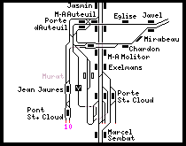
Paris, France Metro
![]()
Paris Metro Ligne 10 at Mirabeau. Photo by David Pirmann, September 2008.
Overview
So, you want to railfan the Paris Métro. A good portion of the system can be seen in a short time (perhaps 2 or 3 days) depending on what you're interested in. The system (and in fact the city) is fairly compact compared to the New York Subway or even the London Underground and so if you plan wisely the entire thing can be covered with plenty of time to visit other Paris attractions.
Some of Paris' transportation highlights include the following:
- Above-ground portions (mostly the 2 and 6 lines)
- Railfan window view (only on the 14, which is fully automated)
- Rubber-tired rolling stock (the 1, 4, 6, 11, and 14)
- Some short shuttles, loops, and "diverging" lines (7bis, 3bis, 10)
- Double-deck cars on the RER lines; new large, deep, fancy stations on the RER E
- Two tram lines running in the north and west of the city
A month or so prior to our trip we sat down and decided what things there were of interest that we definitely wanted to see. I used the Paris Métro Handbook which is filled with photographs of Métro stations to help decide what stations were must-sees. The Handbook is available in English from the London Transport Museum and other sources. (It is, in fact, one of the only books about the Paris Métro in English. I believe there have been two editions thus far; the content is similar but the photographs are vastly different. Both editions are worth picking up if you can find the older one.)
We had decided that the must-do items were the Line 14-Méteor, the new high-speed, fully automated, driverless Métro line; the elevated portions of the 2 and 6 lines; the station Mirabeau on line 10, and as much of the rubber-tired lines as possible. We also wanted to visit the tram lines in the outskirts of the city. Other than that we did not really plan an itinerary in advance. Below is the itinerary we eventually did follow, based on our April, 2000 visit.
We arrived in Paris on a Saturday afternoon and convened at the Hotel Ibis near Gare de l'Est. The Gare de l'Est and Gare du Nord area is perfect as a home base to visit Paris. There are many hotels in the area (inexpensive, too!) and it is convenient to the Métro lines 4, 5, 7 at Gare de l'Est and RER lines B, D, and E at Gare du Nord.
We departed the hotel around 7:30 PM Saturday evening (it was still daylight), and descended into the Gare de l'Est Métro station, which serves lines 4, 5, and 7. There are two platform areas, one for the 4, which is two tracks with two side platforms, and another serving the 5 and 7, which is two island platforms and four tracks. We bought a carnet of tickets each (at a cost of 5.50 FF per ticket), and started our first Métro journey on Line 4, heading south to the transfer station at Strasbourg St. Denis.
The Strasbourg St. Denis station serves the number 4 on the upper level and lines 8 and 9, one above the other, underneath the number 4. Lines 8 and 9 are in a two-level subway underneath Boulevard Bonne Nouvelle and Boulevard Poissonnière between République and Richelieu-Drouot, with line 8 on the upper level and 9 beneath. The upper level stations have high arched ceilings, whereas the lower level stations look more like typical cut and cover stations with low ceilings and a heavy concrete wall between the tracks. We rode line 9 to Bonne Nouvelle station where we exited the Métro in search of dinner, which we found in a cafe on the south side of the Boulevard Bonne Nouvelle.
By now it was dark, but there was still a couple of hours before the Métro closed down for the night. So, after dinner, we re-entered the Métro a few blocks further down at Grands Boulevards (formerly Rue Montmartre) station, where we rode the number 8 train to Concorde, leaning out for photographs at Opéra and Madeleine. (One of my goals was to stop and photograph each station along the lines we traveled but even with the frequent service in Paris-- more frequent than in New York even in the off-peak hours-- this practice grew tiresome very quickly and was reserved for the more interesting areas. That's not to say we didn't make plenty of stops!)
At Concorde station, we got our second taste of the rubber tired trains when we transferred to the number 1, and rode one stop to Charles De Gaulle-Étoile station. De Gaulle-Étoile station (formerly just "Étoile") is a transfer point between the 1, 2, and 6 lines, with the loop terminal track for the number 6 adjacent to the eastbound (direction Château de Vincennes) platform of the number 1. This allows an across-the-platform transfer from the eastbound 1 to the 6; for crowd-control reasons, passengers arriving on the number 6 must go down to the underpass and up to the number 1's platforms. Formerly, a "portillon automatique" was used to block the passage to enforce the proper flow of passengers. They're no longer used but still in place, at least at this station.
Switching to the number 6, we departed for the left bank and an elevated trip across the southern half of Paris. Our first stop was the first open-air station on the line, Passy. We took some night photographs and reminded ourselves to be sure to re-visit in the daylight hours. Departing Passy, we cross the Seine on a viaduct on top of a road bridge and arrive at the well known, busy station Bir-Hakeim, which even at this hour (approaching 10:00 pm) is quite busy (almost dangerously so) due to the fact that it is the closest station to the Eiffel Tower (a nice view of which can be had from the bridge over the river while approaching the station). We jump off here and walk over to the tower.
A quick walk around the base of the tower and we find ourselves back at Bir-Hakeim, since there really is no closer Métro station worth walking to. Back on the number 6, we ride through some other open-air stations and arrive at Raspail, a transfer point between the 6 and the number 4, which, if you recall, takes us back to our hotel. We make a couple of stops along the way, firstly at Vavin and next at Saint Germain des Prés, a station which was being refinished during our visit. (The Métro shuts down at night, approximately between 1:15 am and 5:30 am, allowing work to be done without interference from trains or passengers.)
A couple more stops before "home", first at Cité station. This is a relatively deep station between two branches of the Seine river serving the Ile de la Cité. The station is served by elevators from each platform at the south end, as well as a large staircase, leading up to the mezzanine area. The north end has a similar staircase marked "passage interdit," i.e. emergency exit. The station has a high arched ceiling and unique light fixtures along the platform walls. The station appearance is not as vert as it appears in the photographs- the lighting and unfiltered lens make it appear moreso than it really is. I suffered this problem at a number of other stations, as well. (On my 1997 visit, I walked by Cité and snapped a picture of its art nouveau railings at street level.) Then, another stop was made at Etienne Marcel. We wait for a few extrordinarily crowded trains to pass (it was almost midnight) and then jump on a fairly empty one to return to Gare de l'Est and sleep after a long flight over and a few hours of railfanning.
Sunday morning we walked over to Gare du Nord for an English-style breakfast in the upper level restaurant and some views of the TGV trains in the early morning hours. Then, back to the Métro and a short hop along the number 4 to Barbès-Rochechouart, which is a transfer station between the underground 4 and the elevated 2 line. The number 2 has four elevated stations which we explored thoroughly.
Departing Barbès-Rochechouart, direction Nation, the next elevated station is La Chappelle. At each of the elevated stations there is a nice view up and down the tracks which have some pretty big grades in some places. Up next is Stalingrad station. Here we exited the Métro and walked along the route of the elevated since the next station, Jaurès is so close. The walk allows a good view of the trains from the street. At Jaurès station, the track curves sharply as it enters the station, direction Nation.
Jumping back on the train we made a couple of short stops in the underground stations of the number 2 (for example, Menilmontant) before arriving at Nation, a transfer point between the 1, 2, 6 and RER. The RER station is quite interesting; two tracks in the middle, with two huge, wide side platforms under a high domed ceiling. We stop to take a look and then back upstairs to the line 6 platform. We take a short journey on the number 6, stopping at Daumesnil, Bel Air and Bercy, the latter of which is a transfer point to the new Line 14 aka Méteor.
Line 14 operates completely unattended, with no motorman or conductor. The fixed-length rolling stock has no cabs in front so there is a perfect railfan view out the front picture window. The cars themselves are articulated with no bulkhead walls between the cars so one can look from one end of the train to the other without anything blocking the view. (These are the same cars as on the number 1, the MP89 stock, but without the driver's compartment at the head/tail ends.) We rode the number 14 two stops south, crossing under the River Seine to the current southern terminal at Bibliotheque François Mitterand, and then back in the other direction toward Madeleine using the railfan seat the whole way. We stopped at the current terminal at Madeleine and watched the automated train head into the tail track, reverse, and cross over to the southbound side; then we rode back to Bercy to rejoin the number 6 line in its elevated tour across the south side of Paris.
The elevated section of line 6 (and 2, of course) are probably the most frequently photographed sections of the Paris Métro because of the availability of daylight but even so they are probably the most scenic. Different vantage points allow for photographs of the trains approaching, ascending and descending into the tunnels, and even from footbridges across the tracks at certain stations. We made several more stops at open-air stations along the line, first at Quai de la Gare, on the bank of the River Seine, with a good view of the bridge across the river carrying the trains. A long zoom (around 200mm) will provide a nice view all the way down the length of the bridge as the trains approach.
Next up, two more enclosed elevated stations at Chevaleret and Courvisart, and then a surface-level open air station at St. Jacques. As noted before, there is a pedestrian overpass at St. Jacques between the road on either side of the tracks. Departing St. Jacques, we arrived at the underground station Montparnasse-Bienvenüe, a large transfer station adjacent to the tallest building in France. Gare Montparnasse is a good place to spot some TGVs, as well as to grab a quick lunch. By the time we arrived here, we had been "on the road" for about three hours and had taken 100 photographs!
After lunch we walked down the road to the other Montparnasse-Bienvenüe station, this one serving line 12. We took a short journey along line 12 to Sèvres-Babylone where we transfered to line 10 for a ride into the southwest side of Paris. We were interested in the section of line 10 that was formerly a loop, serving Javel, Église d'Auteuil, Michel-Ange Auteuil, Porte d'Auteuil, Michel-Ange Molitor, Chardon Lagache, and Mirabeau stations. This section is no longer operated as a loop, except maybe in short turn situations. The line was extended at the far end of the loop to serve Jean Jaures and Pont St. Cloud/Bologne station.
Our first stop along this route was at Michel-Ange Auteuil station, an island platform with two tracks. An unusual configuration for Paris by itself, this station is more unusual in that the north side track is merely a non-revenue connection from line 9 to line 10, and there is a chain-link fence along the platform edge. The reason it was built is unclear, but from looking at the track map, a loop from line 9 making the following stops could be possible: Jasmin (9), Michel-Ange Auteuil north side platform, crossing over to the main running track of line 10 either before or after Porte d'Auteuil station, then south through the disused station at Murat, and around and under the line 9 running tracks into the center island platform at Porte St. Cloud (line 9). As it stands right now, the north side track, the line serving Murat station, and the loops around Porte St. Cloud are merely used for yard access (Ateliers de St. Cloud).
Our next station stop was at Porte d'Auteuil, a station with two island platforms and three tracks. While it might appear that this station has been built excessively large for a line that has trains in only one direction, this station is one of the two which serve the "Parc des princes" soccer stadium. This station acts as a terminal for some trains, sending them back around the loop directly to Michel-Ange Molitor, while others continue to Bolougne. As described above, this station was probably built in anticipation of extra service around the loop coming from line 9. However, the Murat station was never opened to the public, therefore it's unlikely any service ever operated in this manner.
We rode a train bound for Boulogne to the end, and waited for it to head back into Paris. The next station we stopped at was the well-known Mirabeau station, which is served only in the inbound direction and only has a single side platform. However, the outbound trains on the loop pass through Mirabeau without stopping, on an inclined trackway, and turn sharply north into the loop at the very edge of the Mirabeau station. The pictures will clearly show what is fairly hard to describe in adequate words. Suffice it to say there is nothing else like it that I can think of, on any transit system I am familiar with.
Continuing on, we decided to take an afternoon break and return to the hotel. Our route back took us to the transfer station at La Motte Piquet/Grenelle where we switched from the 10 to the 6, and we retraced our steps of the previous evening back to Charles De Gaulle-Etoile station, where we transfered to the number 2 to Barbes-Rouchouart, where our morning journey began, then south two stops on the number 4 back to Gare de l'Est. I had accumulated 230 digital photographs in our first two days in Paris.
A few hours later, our evening's itinerary was chosen over a quick dinner at Quick, a Parisien burger joint across the street from the main entrance to Gare de l'Est. We decided to check out the loop of line 7bis, and to get there we rode the number 5 several stops from Gare de l'Est to Jaurès, underground where we had been that morning on the number 2. We transfered here to the 7bis, and rode one stop to Bolivar, a typical Parisien Métro station with two side platforms, although in this case they were blocked off about halfway up since the 7bis runs 3-car trains at all times. The Bolivar station had an exhibit about its namesake on the inbound platform.
We rode through the next two stops, Buttes-Chaumont and Botzaris, then alighted the train at Place des Fêtes, which is served in only one direction around the 7bis loop. The station is unusual in that it is an island platform with an unused north-side track, which in this case is simply a siding on which trains can be parked. It doesn't lead anywhere execpt to-and-from the loop track. (However, departing Place des Fêtes, there is a spur track leading down to Porte des Lilas on the 3bis, passing two unused stations, Haxo and Porte des Lilas.)
Our next station stop was at Pré Saint Gervais, again an island platform served only on the "inside" platform face. The other platform face is mostly walled off and is used as an inspection pit area for the trains on the 7bis line, although the only access to this track from the 7bis is via a reverse move between here and the next station, Danube. Danube is also an island platform station served on the "inner" track only. Departing Danube, the two tracks merge and become the single inbound running track into Botzaris station, which has a heavy concrete wall between the trackways.
We then rode the number 7bis to its terminal at Louis Blanc. The inbound 7bis stops at an island platform adjacent to the main line number 7 train. To pick out outbound 7bis passengers the train reverses and departs back the way it came, and then reverses again and switches over to enter the outbound station area, where an island platform allows transfer between the 7 and 7bis.
To finish our full day of riding the Paris Métro, we rode the number 7 south stopping first at Palais Royal-Musée du Louvre and then on to Place d'Italie, a station with an island platform that is actually part of a loop and stabling area for the number 7 trains. (Paris does not have large yards like New York City does- since the Métro shuts down at night, trains can be stored in stations and in small stabling areas along the lines. They have no need for massive yards like at Coney Island.) At Place d'Italie we transfered to the number 5 for the return trip, non-stop, to Gare de l'Est.
The next day, Monday, was a short one, due to illness on my part and needing to get in some general sightseeing while I was in Paris. So, the rest of this article will be a conglomeration of multiple small railfan trips arranged so that you can easily do them yourself in a single day.
The next portion of the Métro I covered, on my own this time, was part of line number 11 and the 3bis shuttle operation. Starting at République on number 11, and making quick stops at Goncourt and Pyrénées stations, I arrive at Porte des Lilas, a 3-track, 1-island, 1-side platform station, and head down a long transfer corridor (Paris loves long transfer corridors) to the station serving the 3bis shuttle. The 3bis station is on a loop for turning and stabling trains but from the track map it is clear that the "main" line was intended to continue north and join with the 7bis loop via Haxo and Pré Saint Gervais.
Starting at the 3bis Porte des Lilas platforms, the 3bis shuttle makes quick station stops at Saint Fargeau and Pelleport, at neither of which did I stop since the train frequency on this line at this time of day was pretty low, but I was able to lean out and take a snapshot. The more interesting part of the line is at Gambetta station. The main line 3 was formerly connected directly to the shuttle at Gambetta, and in fact the transfer corridor from the 3bis to 3 is through the former running tunnel.
The current station platforms serving the main portion of line 3 were built when the line was extended eastward to Gallieni, in 1971. A former station, Martin Nadaud, slightly west of the current platforms serving line 3, was "closed" and made part of the entry/exit to this new Gambetta station. From here, the line 3 train took me to Gare St. Lazare (the mainline railroad station is depicted in well-known paintings by Monet), from which a couple of out-and-back trips can be made to cover some other notable sights. First, for a change of pace I transfered to the RER-E train at Hausmann-St. Lazare. The new RER-E station here and at Magenta (Gare du Nord) are deep, cavernous spaces with two island platforms and four tracks. The ride from Hausmann to Magenta is short and smooth.
Our destination for the next portion of our visit is on Métro line 12, which can be reached in two ways from Magenta (Gare du Nord). Either switch sides and ride the RER back to Hausmann-St. Lazare (which might take a while to wait for the next train) or exit up to the surface and transfer to the number 4 Métro at Gare du Nord. At St. Lazare, hop on line 12 at St. Lazare and head north, direction La Chapelle. From Gare du Nord, use the Métro 4 direction Porte de Clignancourt and transfer to the Métro 12 at Marcadet-Poissoniers, and take line 12 direction Mairie d'Issy.
No trip to railfan the Paris Métro would be complete without stopping at Abessess station on line 12. The station is at the base of the Montmartre district and is a short walk to the funicular that will take you up to Sacre Coeur, but is also notable for its Hector Guimard art nouveau kiosk on the surface. (We will visit another such kiosk at Porte Dauphine, below.)
Returning to line 12, I rode back to St. Lazare, and hopped onto the Métro line 13 for (what I thought was to be) a short visit to Liège station. Similar to Mirabeau in that a train passes through apparently without stopping, Liège is set up with two side platforms offset from one another a short length. There is no wall separating the two directions from one another letting you have a good view of trains passing in the opposite direction. The station walls feature detailed mosaics depicting scenes of the history of the city of Liège.
The short trip to Liège was not as short as I had hoped; Métro line 13 is extremely crowded during rush hour and it was impossible to get on a southbound train. I rode north all the way to Mairie de St. Ouen and crossed over hoping to be able to board a train during the morning rush hour. From the map I had assumed that La Fourche would be a good place to make the transfer since it is served by both branches of the 13, however, the station does not have a single island platform for the southbound trains- they are one above the other, cutting your options for boarding a train in half. Keep this in mind if you travel the number 13 during rush hour.
I eventually bailed out of the 13 at Place de Clichy, to which I could have probably walked from La Fourche but not knowing the territory I suffered through the overcrowded trains much longer than I would have liked. At Place de Clichy I transferred to Métro line 2, direction Porte Dauphine, where I exited to view another preserved Guimard kiosk in a park-like setting. This kiosk is apparently not authentic to this station or line, however the cast iron and stained glass "Métropolitain" kiosk at Porte Dauphine is as much a symbol of Paris as the Louvre, Eiffel Tower, or Arc de Triomphe.
Speaking of the Louvre, it was in that direction I headed as I departed Porte Dauphine. I transfered to the number 1 at Charles De Gaulle-Étoile but this time did not linger since we had visited there already on this trip. I was already familiar with line 1 having ridden it all the way between Diderot and La Defense on my previous visit to Paris in 1997. (That visit was spent concentrating on the above ground sights of Paris and I spent relatively little time on the Métro. That's the subject for another kind of travelogue entirely.)
So, heading in direction Château de Vincennes on line 1, I made a stop at Tuilieries station first, which had been our home base of touring in 1997. The station had been completely overhauled, painted, and brightened up since 1997 (see the before and after photos). The walls were covered with images and text depicting the history of the RATP, Paris' transit agency, although the text was essentially unreadable being too small and much of it too high on the walls. A nice try, but this doesn't make up for Paris' (current) lack of a real transportation museum.
I made another quick stop at Louvre-Rivoli station, which compared to Tuilieries was dark and cold feeling-- but I don't mean this in a dark and meanacing way. In fact, it feels very similar to a museum, in no small part due to the art installations from the Louvre's collections along the platform walls. The spotlit art installations are a very noticable contrast to the station's overall feeling of dark and quiet.
Next up, Bastille, the crown jewel of Métro line 1. At this station, the tracks emerge from the tunnel to cross a canal on a bridge (which is in fact a huge square elevated over the canal). Heading eastbound the trains make extremely sharp S-curves approaching the connections. The open-air aspect of the MP89 trains as the train snakes around the curve is pretty eerie. Emerging into daylight, the Bastille station is filled with excellent photo opportunities, despite the only RATP staff we had run into so far that did not appreciate photography on the property. I was able to take a few more photographs from the sidewalk of the bridge at street level without incident. The curved west end of the station has been closed off, replaced with an east-end platform extension on a steep slope. Thinking it might be best not to re-enter Bastille, I walked up to Bréguet-Sabin station on line 5, which has some fancy art nouveau railings and lamps at street level.
Riding south, stop at Quai de la Rapee station, which is similar to Bastille in that it is a surface level station where the tracks peek out from the tunnels just long enough to serve the station. At the north end of the station is a bridge which presumably crosses the same waterway as at Bastille.
Back into the tunnel, and then out again to cross the River Seine on a bridge into the upper level of Gare Austerlitz station. The Métro station is perched above the main line/suburban railroad station on an immense steel structure. The bridge over the river is also an uncharacteristic steel arch structure, unlike the more typical iron and concrete viaducts normally used on river crossings. From certain points along the platform one can look down at suburban trains waiting to depart. Nice views can be had from either end of the platform-- to the north, the River Seine crossing, and to the south a snaking S-curve as the line heads toward Place d'Italie.
Well, that wraps up a third day of visiting the Paris Métro. Obviously there is much more to see and if you are dividing your time between railfanning and sightseeing you will no doubt visit other stations not mentioned here. The RER is a convenient way to get to some common destinations, for instance if you fly into or out of Roissy-Charles De Gaulle airport, RER-B is the method of choice to get into downtown Paris. The fare from the airport includes transfer to the Métro good for through-travel to any Métro station. The trip takes about an hour. As you get close to Gare du Nord, the TGV maintenance facility can be seen on the west side of the train. The RER C line serves the Musée d'Orsay and Versailles, and RER A heads out to Disneyland Paris.
Speaking of TGVs, no trip to France would be complete without a ride. There are several TGV web sites that detail some short, inexpensive trips so I won't go into those here. I have had a chance to ride both the Eurostar (which is essentially only a TGV as far as the Channel Tunnel, after which it becomes a "train of normal vitesse"), and the Thalys from Paris to Brussels. Gare du Nord and Gare Montparnasse are good places to see TGVs sitting still.
Line By Line
 Line 1
Photo locations: La Défense, Esplanade de La Défense, Pont de Neuilly, Les Sablons, Porte Maillot, Porte Maillot Ancienne (Abandoned), Argentine, Charles de Gaulle - Etoile, Georges V, Franklin D. Roosevelt, Champs-Elysées-Clemenceau, Concorde, Tuileries, Palais Royal - Musée du Louvre, Louvre - Rivoli, Châtelet, Hôtel de Ville, Saint-Paul, Bastille, Gare de Lyon, Reuilly-Diderot, Nation, Porte de Vincennes, Saint-Mandé-Tourelle, Bérault, Château de Vincennes, (Misc/Unknown)
Line 1 runs some of the newest rolling stock, the MP89, and is rubber-tired. The rubber tired lines have much faster and smoother accelleration than the steel wheeled lines. The trains are also interesting in that they are essentially a single "tube" with no doors in between. The sections between cars are jointed allowing easy pass-through between cars and open lines of sight from end to end. The line is mostly cut-and-cover construction. The line is carried on a bridge in between automobile lanes over the river Seine on its way to La Defense; views of the bridge can be had from the plaza above Esplanade de la Defense station. Line 1 is planned to be converted to driverless operation (see line 14, below), and in preparation for this, the stations are receiving short platform edge gates. The Bastille station, the only surface station on line 1, is probably the highlight of the line; there are some nice views of the line from the platforms and the surrounding plaza. Line 1 connects many of the main tourist sites in Paris: the Arc d'Triomphe, the Champs Elysee, place de la Concorde, the Tuilieries gardens, the Louvre, Chatelet-Les Halles, and the Marais district.
 Line 2
Photo locations: Porte Dauphine, Victor Hugo, Charles de Gaulle-Etoile, Ternes, Courcelles, Monceau, Villiers, Rome, Place de Clichy, Blanche, Pigalle, Anvers, Barbès-Rochechouart, La Chapelle, Stalingrad, Jaurès, Colonel Fabien, Belleville, Couronnes, Ménilmontant, Père Lachaise, Philippe Auguste, Alexandre Dumas, Avron, Nation, (Misc/Unknown)
Line 2 makes a loop across the north end of Paris between Charles de Gaulle-Étoile and Nation (with the Line 6 providing the southern half of the loop). There are a number of stations on elevated structure: Barbès-Rochechouart, La Chapelle, Stalingrad, and Jaurès, which provide nice views of the trains approacing along the elevated line. The short distance between Stalingrad and Jaurès provides some nice views from street level. In addition, the station at Porte Dauphine still has a Hector Guimard art nouveau kiosk at street level (although it is apparently not native to that station). New rolling stock (the MP01) has been deployed, which is very similar to the MP89 open, articulated design. Line 2 serves the Montmartre district around Blanche, Pigalle, and Anvers stations. The famous Moulin Rouge is located at Blanche.
 Line 3
Photo locations: Pont de Levallois-Bécon, Anatole France, Louise Michel, Porte de Champerret, Pereire, Wagram, Malesherbes, Villiers, Europe, Saint-Lazare, Havre-Caumartin, Opéra, Quatre-Septembre, Bourse, Sentier, Réaumur-Sébastopol, Arts et Métiers, Temple, République, Parmentier, Rue Saint-Maur, Père Lachaise, Gambetta, Ateliers de St. Fargeau, Porte de Bagnolet, Gallieni
At Gambetta station, transfer from the 3 to the 3bis is made through a former running tunnel. The Gambetta station on the main line was relocated during the extension of the line; a former station's platforms (called "Martin Nadaud") has been incorporated into the entrance to Gambetta. Recently Gambetta has received a makeover with new lighting. Other stations with interesting vantage points are Porte de Champerret and the terminal at Gallieni.
 Line 3bis
Photo locations: Porte des Lilas, Saint-Fargeau, Pelleport, Gambetta
The short shuttle line, Line 3bis, is part of the original main line routing. It was separated when line 3 was extended eastward. Remains of the terminal loop exist just east of Gambetta, and there is another loop at the north end past Porte des Lilas. The trackage of line 3bis is partially connected to that of line 7bis at Porte des Lilas; there has been discussion to finally join 3bis and 7bis into one longer line.

 Line 4
Photo locations: Porte de Clignancourt, Simplon, Marcadet-Poissonniers, Château Rouge, Barbès-Rochechouart, Gare du Nord, Gare de l'Est, Château d'Eau, Strasbourg-Saint-Denis, Réaumur-Sébastopol, Etienne Marcel, Les Halles, Châtelet, Cité, Saint-Michel, Odéon, Saint-Germain-des-Prés, Saint-Sulpice, Saint-Placide, Montparnasse-Bienvenüe, Vavin, Raspail, Denfert-Rochereau, Mouton-Duvernet, Alésia, Porte d'Orléans, Mairie de Montrouge
Line 4 is another rubber-tired line, which makes the trains appear to perform better (accellerate faster). The Cité station is especially interesting; it is a deep level station on the Ile de la Cité between two crossings of the river Seine. Its high ceiling, stairways, and lighting are unique in the system, although the next station south, Saint-Michel, is very smiliar. Line 4 connects the northern parts of Paris around Gare du Nord with the Latin Quarter.
 Line 5
Photo locations: Ateliers de Bobigny, Bobigny - Pablo Picasso, Bobigny-Pantin - Raymond Queneau, Eglise de Pantin, Hoche, Porte de Pantin, Ourcq, Laumière, Jaurès, Stalingrad, Gare du Nord, Gare du Nord Ancienne (Abandoned), Gare de l'Est, Jacques Bonsergent, République, Oberkampf, Richard-Lenoir, Bréguet-Sabin, Bastille, Quai de la Rapée, Pont Austerlitz, Gare d'Austerlitz, Saint-Marcel, Campo-Formio, Place d'Italie
The section of line between Gare d'Austerlitz and Quai de la Rapée is open air; in fact, the Austerlitz station is in the ceiling of the main line station below. One can look down on the trains and tracks below the Métro platforms. The bridge across the river Seine is a nice steel arch which can be seen from the northern end of the platforms at Austerlitz. Quai de la Rapée station is on a crossing over a canal with tunnels on both sides; the tunnel to the south is very short and leads to the river crossing. An abandoned station on a former loop track at Gare du Nord is often visited by fan trips. Line 5 connects three major railroad stations: Nord, Est, and Austerlitz.
 Line 6
Photo locations: Charles de Gaulle-Etoile, Kléber, Boissière, Trocadéro, Passy, Pont de Bir-Hakeim, Bir-Hakeim, Dupleix, La Motte-Picquet-Grenelle, Cambronne, Sèvres-Lecourbe, Pasteur, Montparnasse-Bienvenüe, Edgar Quinet, Raspail, Denfert-Rochereau, Saint-Jacques, Glacière, Corvisart, Place d'Italie, Nationale, Chevaleret, Quai de la Gare, Bercy, Dugommier, Daumesnil, Bel Air, Picpus, Nation
Line 6 features the most open-air stations of all of the lines and offers a number of good photo opportunities from the platforms; often the tunnel portals are visible a short distance down from the stations, for instance at Bel Air and Passy. The line crosses the river Seine on a bridge between Passy and Bir Hakeim (the closest station to the Eiffel Tower so it is always thronged with tourists). The station at Charles de Gaulle-Étoile is a single track loop (the "terminal", where the trains lay over, is one stop down at Kléber).
 Line 7
Photo locations: La Courneuve-8 mai 1945, Fort d'Aubervilliers, Aubervilliers-Pantin Quatre Chemins, Ateliers de la Villette, Porte de la Villette, Corentin Cariou, Crimée, Riquet, Stalingrad, Louis Blanc, Château-Landon, Gare de l'Est, Poissonnière, Cadet, Le Peletier, Chaussée d'Antin-La Fayette, Opéra, Pyramides, Palais Royal - Musée du Louvre, Pont Neuf, Châtelet, Pont Marie, Sully - Morland, Jussieu, Place Monge, Censier-Daubenton, Les Gobelins, Place d'Italie, Tolbiac, Maison Blanche, Le kremlin-Bicêtre, Villejuif - Léo Lagrange, Villejuif - Paul Vaillant Couturier, Villejuif - Louis Aragon, Porte d'Italie, Porte de Choisy, Porte d'Ivry, Pierre Curie, Mairie d'Ivry
Line 7 is a long line served by steel-wheel trains. It runs mostly on the eastern side of Paris with a push into "midtown" serving the Opera, Louvre, and Chatelet-Les Halles. At Louis Blanc the line 7bis splits off; there are two island platforms offset from each other, with two through tracks for line 7 and two terminal tracks for 7bis, although recently the 7bis trains are using only one platform. This is apparently in preparation for further extension southward of line 7bis, separate from line 7.
 Line 7bis
Photo locations: Louis Blanc, Jaurès, Bolivar, Buttes Chaumont, Botzaris, Place des Fêtes, Danube, Pré-Saint-Gervais, Haxo (Abandoned), Porte des Lilas-Cinema (Abandoned)
The line 7bis is a short shuttle around a loop, operated by rolling stock unique to this line, with single axle steerable trucks. At Pré Saint Gervais station there is a siding with an inspection pit where day-to-day maintenance is performed on this small fleet. The cars are otherwise similar to the MP89 stock with articulated joints between the cars. There is a spur of the line toward Porte des Lilas that has never been used in service; there are two unused stations on this line: Haxo and Porte des Lilas (Cinema) -- so called because it is often used for film productions. There has been discussion to join line 3bis and line 7bis into a through-routed metro line.
 Line 8
Photo locations: Balard, Lourmel, Boucicaut, Félix Faure, Commerce, La Motte-Picquet-Grenelle, Ecole Militaire, La Tour-Maubourg, Invalides, Concorde, Madeleine, Opéra, Richelieu-Drouot, Grands Boulevards, Bonne Nouvelle, Strasbourg-Saint-Denis, Saint Martin (Abandoned), République, Filles du Calvaire, Saint-Sébastien-Froissart, Chemin Vert, Bastille, Ledru-Rollin, Faidherbe-Chaligny, Reuilly-Diderot, Montgallet, Daumesnil, Michel Bizot, Porte Dorée, Porte de Charenton, Liberté, Charenton-Ecoles, Ecole Vétérinaire de Maisons-Alfort, Maisons-Alfort-Stade, Maisons-Alfort-Les Juilliottes, Créteil-L'Echat, Créteil-Université, Créteil-Préfecture, Pointe du Lac
Line 8 is a long line serving the southeastern and southwestern parts of Paris, with a journey through "midtown" along the Grands Boulevards. The section between République and Richlieu where the 8 runs directly above the 9 (but all trains make all stops instead of some providing express service). The stations in this section are different from most in that they have a thick wall in between the trackways on each level, presumably for extra support for the lower level. The southeastern end has some above-ground stations outside the former walls of the city of Paris.
 Line 9
Photo locations: Pont de Sèvres, Billancourt, Marcel Sembat, Porte de Saint-Cloud, Porte Molitor (Murat) (Abandoned), Exelmans, Michel-Ange-Molitor, Michel-Ange-Auteuil, Jasmin, Ranelagh, La Muette, Rue de la Pompe, Trocadéro, Iéna, Alma-Marceau, Franklin D. Roosevelt, Saint-Philippe-du-Roule, Miromesnil, Saint-Augustin, Havre-Caumartin, Chaussée d'Antin-La Fayette, Richelieu-Drouot, Grands Boulevards, Bonne Nouvelle, Strasbourg-Saint-Denis, République, Oberkampf, Saint-Ambroise, Voltaire, Charonne, Rue des Boulets, Nation, Buzenval, Maraîchers, Porte de Montreuil, Robespierre, Croix de Chavaux, Mairie de Montreuil
Line 9 shares some right of way with Line 8 between Richelieu Drouot and Republique. In the southwest it crosses line 10 in two places (Michel-Ange-Molitor and Michel-Ange-Auteuil). Complex trackage in this area allows outbound trains on line 9 to loop onto line 10, through a disused station at Porte Molitor (Murat), and back onto the line 10 inbound at Porte St. Cloud. The idea for this would be to provide extra service on line 9 for events at the Parc des Princes arena, but the station at Murat never opened and service has never run in this manner. The extra trackage is used for stabling trains.
 Line 10
Photo locations: Boulogne-Pont de Saint-Cloud, Boulogne-Jean Jaurès, Michel-Ange-Molitor, Chardon-Lagache, Mirabeau, Porte d'Auteuil, Michel-Ange-Auteuil, Eglise d'Auteuil, Javel-André Citroën, Charles Michels, Avenue Emile Zola, La Motte-Picquet-Grenelle, Ségur, Duroc, Vaneau, Sèvres-Babylone, Croix Rouge (Abandoned), Mabillon, Odéon, Cluny-La Sorbonne, Maubert-Mutualité, Cardinal Lemoine, Jussieu, Gare d'Austerlitz
Mirabeau. That station alone makes the line 10 worth a visit. The route in that area diverges into two separate trackways (originally and still part of a loop). The Mirabeau station only has a platform on the eastbound direction; the westbound trains pass through without stopping. However, apparently the grade for the westbound route increases so that the trackway through the Mirabeau station is on a ramp. It's so unusual I've never seen anything else like it anywhere (Liege station on Line 13 is similar but not quite as impressive).
 Line 11
Photo locations: Châtelet, Hôtel de Ville, Rambuteau, Arts et Métiers, République, Goncourt, Belleville, Pyrénées, Jourdain, Place des Fêtes, Télégraphe, Porte des Lilas, Mairie des Lilas
This is another of the rubber-tired lines and it is the shortest of all the main Métro lines. It was built to replace a funicular/rack railway in the Belleville neighborhood and thus the stations in that area are very deep, served mainly by elevator. Line 11 can be used to transfer between lines 3bis (at Place des Fetes) and 7bis (at Porte des Lilas).
 Line 12
Photo locations: Front Populaire, Porte de la Chapelle, Marx Dormoy, Marcadet-Poissonniers, Jules Joffrin, Lamarck-Caulaincourt, Abbesses, Pigalle, Saint-Georges, Notre-Dame-de-Lorette, Trinité-d'Estienne d'Orves, Saint-Lazare, Madeleine, Concorde, Assemblée Nationale, Solférino, Rue du Bac, Sèvres-Babylone, Rennes, Notre-Dame-des-Champs, Montparnasse-Bienvenüe, Falguière, Pasteur, Volontaires, Vaugirard, Convention, Ateliers de Vaugirard, Porte de Versailles, Corentin Celton, Mairie d'Issy
Abbesses station still has its Hector Guimard kiosk on the surface; Abbesses carries the secondary name "Funiculare de Montmarte" but Anvers on line 2 is probably closer. Line 12 can be used to connect between mainline stations at Saint-Lazare and Montparnasse.
 Line 13
Photo locations: Les Courtilles--Asnières-Gennevilliers, Les Agnettes, Gabriel Péri, Mairie de Clichy, Porte de Clichy, Brochant, Saint-Denis-Université, Basilique de Saint-Denis, Saint-Denis-Porte de Paris, Carrefour Pleyel, Mairie de Saint-Ouen, Garibaldi, Porte de Saint-Ouen, Guy Môquet, La Fourche, Place de Clichy, Liège, Saint-Lazare, Miromesnil, Champs Elysées-Clemenceau, Invalides, Varenne, Saint-François-Xavier, Duroc, Montparnasse-Bienvenüe, Gaîté, Pernety, Plaisance, Porte de Vanves, Malakoff -Plateau de Vanves, Malakoff-Rue Etienne Dolet, Châtillon-Montrouge
Liège station is similar to Mirabeau, with a trackway passing through without a platform face; the station is really two separate stations for north and southbound trains due to the narrowness of the street above. Note: During rush hour this line is extremely crowded and should be avoided in the morning for casual railfanning. Plans have been discussed to hand over the western branch between La Fourche and Les Courtilles to an extension of line 14 from Saint-Lazare.
 Line 14
Photo locations: Saint-Lazare, Madeleine, Pyramides, Châtelet, Gare de Lyon, Bercy, Cour Saint-Emilion, Bibliothèque François Mitterrand, Olympiades
The Line 14, or Méteor as it was called during construction, is a brand new line constructed to allieviate overcrowding on line 1 and RER A between Gare de Lyon and Saint-Lazare. The trains are operated completely unattended: no motorman, no conductor. The line's computer operates the whole thing including switching at the end of the line. It is quite fascinating to watch. The rolling stock, MP89CC, similar to that on Line 1, does not have operating cabs at the ends; instead there are passenger seats and large picture windows for watching out the front. Each station has platform edge doors which make it hard to photograph the trains; the best you can do is from the overpasses at each station. The platform edge doors and automated operation make the line almost appear to be a model railroad. Its initial 7km section includes what might be the longest stretch between stations anywhere on the Metro. Since its opening it has been extended northward (from Madeleine to Saint-Lazare) and southward (from Mitterand to Olympiades).
Line Statistics
| Line | Number of Stations | Length of Line | Number of Trains Required-Peak Service | Rolling Stock Type | Depots | Stables |
|---|---|---|---|---|---|---|
|
|
25, 1 open-air | 16.6 km | 46 | MP89 (MP59 previously) | Fontenay (near Château de Vincennes station) | La Defense, Porte Maillot, Château de Vincennes |
|
|
25, 4 open-air | 12.3 km | 39 | MF01 (MF67 previously) | Charonne (near Nation station) | Porte Dauphine, Nation |
|
|
25 | 11.7 km | 40 | MF67 | Saint Fargeau (near Gambetta station) | Gallieni, Porte des Lilas, Porte de Champeret, Pont de Levallois |
|
|
4 | 1.3 km | 4 | MF67 | Saint Fargeau (near Gambetta station) | Gallieni, Porte des Lilas, Porte de Champerret, Pont de Levallois |
|
|
26 | 10.6 km | 42 | MP59 | Saint Ouen (near Porte de Clignancourt station) | Porte de Clignancourt, Porte d'Orleans |
|
|
22, 2 open-air | 14.6 km | 45 | MF67 | Bobigny (near Bobigny station) | Bobigny, Eglise de Pantin, Place d'Italie |
|
|
28, 13 open-air | 13.6 km | 37 | MP73 | Place d'Italie | Nation, Place d'Italie, Kléber |
|
|
38 | 22.4 km | 64 | MF77 | Choisy (near Porte de Choisy station) | La Courneuve, Porte de la Villette, Porte d'Ivry, Mairie d'Ivry, Villejuif |
|
|
8 | 3.1 km | 6 | MF88 | None | Pré Saint Gervais |
|
|
37, 3 open-air | 22.1 km | 51 | MF77 | Javel (near Lourmel station) | Balard, Lourmel, République, Maisons Alfort, Créteil Prefecture |
|
|
37 | 19.6 km | 59 | MF67 | Boulogne (near Pont de Sèvres station) | Pont de Sèvres, Porte de Saint-Cloud, République, Porte de Montreuil, Mairie de Montreuil |
|
|
23 | 11.7 | 22 | MF67 | Porte d'Auteuil (near Porte d'Auteuil station) | Gare d'Austerlitz, Porte d'Auteuil |
|
|
12 | 6.3 km | 18 | MP59, MP73 | Mairie des Lilas (near Mairie des Lilas station) | Châtelet, Porte des Lilas, Mairie des Lilas |
|
|
28 | 13.9 km | 34 | MF67 | Vaugirard (near Porte de Versailles station) | Porte de la Chapelle, Porte de Versailles, Mairie d'Issy |
|
|
30, 2 open-air | 22.3 km | 50 | MF77 | Bagneux (near Châtillion-Montrouge station), Pleyel (near Carrefour Pleyel station) | Gabriel Peri, Porte de Clichy, Saint Denis Université, Carrefour Pleyel, Invalides, Châtillion-Montrouge |
|
|
7 | 7.1 km | 13 | MP89 w/ ATC | Tolbiac-Nationale | Madeleine, Bibliotheque |
Photo Gallery
| Five Random Images | ||||
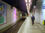 Image 15550 (162k, 1044x705) Photo by: David Pirmann Location: La Défense | 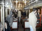 Image 58677 (170k, 1044x698) Photo by: Bernard Chatreau Location: Mairie d'Issy | 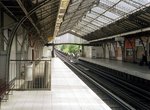 Image 123611 (348k, 1044x707) Photo by: Bernard Chatreau Location: Dupleix | 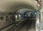 Image 125098 (273k, 1044x788) Photo by: Bernard Chatreau Location: Vaneau |  Image 149103 (371k, 1044x787) Photo by: Bernard Chatreau Location: Victor Hugo |
Page Credits
By David Pirmann.