Orleans, France
![]()
Orléans Citadis Type 301 tram no. 40 crossing the river Loire on Pont George V inbound. Cathedral Sainte-Croix is in the background on the right. Photo by Peter Ehrlich, October 2002.
Overview
The French city of Orléans is 125 km south of Paris, on the River Loire. It's an old and historical city, but not very large: 250,000 inhabitants in the metropolitan area.
In the 1960s, the new town of La Source was built 10 km south of Orléans, with real estate, office buildings (as the "Chèques Postaux" = Post Bank), University and Regional Hospital. The role of the tramway is to connect all parts of this low-density urban area and to limit anarchic urbanization of the suburbs. Line 1 was opened on November 27, 2000.
This line runs north-south and is 18 km long. The average distance between the stops is 800 m and the average speed is 23 km/h. The line is fully segregated from traffic and on some places is established on its own right-of-way.
The tramcars are manufactured by Citadis (Alstom). The operating company is the SEMTAO (Société d'Economie Mixte des Transports en commun de l'Agglomération Orléanaise).
Route Map

Station By Station
Terminus Hôpital de La Source. The line starts just in front of the Hôpital de la Source (C.H.R.O. = Centre Hospitalier Régional d'Orléans). The tram departs heading slightly southbound on its northern run, and we travel along private right-of-way beside the workshop and yards. Before the line opened, this section of line was used to store and test cars during the construction of the depot. On the August pictures, there are some tramcars just delivered and some ones on trial runs (notice the non-hidden wheels).
Then, on the centre of a road, across the woods, we reach the new town of La Source at Bolière stop. We are now eastbound. The next stop, Chèques Postaux was in August 2000 the end of the trial line. The line passes here through the center of La Source. Next stop: Université L'Indien. The line enters in the campus on private right-of-way. After a left curve, we're now northbound. Two more stops: Université Parc Floral and Université Château.
After crossing the rue de Châteauroux, we leave La Source and enter the town of Olivet. The line continues now among the orchards. Lorette stop, a low patronage stop today, but to-morrow? Then a "S" curve, which was planned to serve a new housing and commercial activities center in Olivet at Les Aulnaies stop. It's funny to notice that at this point we are very near to La Source Hospital, our starting point.
Then a long stretch on private ROW, the only ballasted section of the line (not planned-- the soil here did not permit tracks on concrete like everywhere else, and this area was the last to be completed). The line passes under the RN 20 (RN = route nationale = highway), and runs along grassy tracks to the next stop: Victor Hugo.
The line is now on side of a street, then stretches down to the valley of the Loiret (affluent of the Loire) along the RN 20. The line crosses the Loiret on a new bridge and passes on the left, the large shopping center Auchan. The line crosses the RN 20 at ground level to reach the Zénith Parc des Expositions stop. The Zénith is a concert and entertainment hall which looks like a bunker. Departing Zénith, the line is now on the east side of the RN 20 on private right-of-way and the trams are high-speed running (be careful taking pictures here!). On this stretch, we leave Olivet to reach Orléans.
Then finally begins the urban part of the line, with more classical tramway style center tracks. Here, on the rue Basse Moullière, there is a short section of track shared with cars, the only such section of the entire line. The Moullière stop is in a residential area, with a central platform. Next, on reserved central lanes, the line arrives at Croix Saint-Marceau stop, and then continues northbound on central reservation on avenue Dauphine to the Tourelle-Dauphine stop.
It's time to cross the river Loire on George V Bridge to reach the old center of Orléans (mainly 18th century buildings). First stop is Royale-Châtelet on rue Royale. Notice that the cars lanes are on the tram stop platforms! In fact, there is here only local traffic. Across the old center, the line reaches the De Gaulle stop. Then, crossing the main square that is the very center of Orléans, the place du Martroi (with a statue of Joan of Arc, the Maid of Orléans), the line enters the very busy rue de la République, which is reserved today for use by pedestrians-- and the tram. This street is a typical 19th century street which joins the old center and the railway station, with a stop at République.
Leaving the rue de la République, the line has a sharp curve around the Place d'Arc (a shopping center, which includes a bus station and railway station over the street). Gares d'Orléans stop is located here. Turning right in front of a café named "Le Tramway", the line enters a central reservation on rue de la Gare along the stub-end Orléans SNCF station. A stop is made at Antigna, and the line moves to a side reservation along rue de la Gare. The next stop is Coligny. The line then crosses via a twin bridge over the SNCF tracks (between Tours, Orléans and Paris). On private right-of-way past a shopping center, the line reaches Libération stop. Then, on side reservation, the line crosses over a set of SNCF tracks from Paris, then turns left.
Leaving Orléans, the line enters Fleury-lès-Aubrais, a working class town (historically a railwaymen town around Les Aubrais station). Along the SNCF tracks, the line arrives to the Gare des Aubrais stop. Then, the line turns right on narrow streets across a quiet housing neighborhood and reaches Bustière stop. An S curve leads to the center of Fleury, at Lamballe stop, and then straight ahead on avenue des Cosmonautes, the line finally arrives at its stub-end terminus Jules Verne.
Photo Gallery
| Five Random Images | ||||
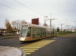 Image 23293 (102k, 850x563) Photo by: Bernard Chatreau Location: Zénith-Parc des Expositions |  Image 23296 (117k, 850x578) Photo by: Bernard Chatreau Location: Mouillère |  Image 23303 (135k, 850x563) Photo by: Bernard Chatreau Location: République |  Image 49261 (166k, 864x574) Photo by: Peter Ehrlich Location: Université-Parc Floral |  Image 49264 (176k, 864x574) Photo by: Peter Ehrlich Location: Gare des Aubrais |
Photos By Location
Photo locations: Hôpital de la Source (Orléans-La Source), Depot, Bolière, Chèques Postaux, Université-L'Indien, Bet. L'Indien & Parc Floral, Université-Parc Floral, Université-Château, Lorette, Les Aulnaies, RN20 Underpass, Victor Hugo, Avenue Victor Hugo, Loriet Bridge, Zénith-Parc des Expositions, Mouillère, Croix Saint-Marceau, Avenue Dauphine, Tourelle-Dauphine, Pont George V, Royale-Châtelet, De Gaulle, Place du Martroi, République, Gares d'Orléans, Antigna, Rue de la Gare-Coligny, Coligny, Libération, Gare des Aubrais, Rue Gustave Rolland, Rue Lamartine, Bustière, Lamballe, Jules Verne (Fleury-les-Aubrais)
Page Credits
By Bernard Chatreau. Route Map by Seth Morgan.