New York, Westchester, and Boston Remains
Location Notes
Kingsbridge Road. Kingsbridge Road was the first outbound stop in Westchester. The northern end existing right of way of the #5 Dyre Ave. subway line is just steps to the south of Kingsbridge Road. The right of way is clearly visible between here and S. 3rd Avenue. The remains of the NYW&B in Westchester County are apparently the property of Metro North (MTA) except where sold off to make stores, homes, or other private-use structures.
Hutchinson River Viaduct. Just south of where the Lincoln Avenue station would have been is the remains of the Hutchinson River Viaduct. Practically nothing remains of the viaduct itself but the ground has obviously been shored up and a concrete abutment for the steel viaduct remains. It can be seen from the highway, only in the winter when all the trees are bare. This is just past where the track splits to go either to Portchester or White Plains.
Chester Heights. At Chester Heights no remains of a train station but the ROW is evident.
New Rochelle. The right of way continues in Nature Study Woods (NSW) in New Rochelle.
Wykagyl. The station is quite decrepit, full of rubble, graffiti and birds. Half the station is gone due to the construction of 1270 North Avenue. A giant wall prohibits access underneath the North Avenue bridge on both sides. Both the northbound and southbound platforms remain, along with the staircases to the second level. About a quarter mile north of Wykagyl station, the right of way continues behind Ward School in New Rochelle.
Continuing across the street from Broadfield Road in New Rochelle into Ward Acres, a large nature reserve. A large overgrown footpath, known to the neighborhood children of yesteryear as "Peewee Highway", marks the New York, Westchester & Boston Railway right of way through the nature reserve.
Continuing north of the "Peewee Highway" at Pinebrook Blvd. in New Rochelle the right of way continues in between Pinebrook Blvd. and the Hutchinson River Parkway. This is not a very well known area. It's also where the Hutchinson River Bridge was located. The bridge was removed in 1988 during the Hutchinson River Parkway rebuild project.
Pine Brook. After the NYW&B's demise, the area under the bridge became popular with homeless people. In fact there may have been homeless living there as late as the 1980's, very rare for the New Rochelle/Scarsdale border. The area is now filled with debris, trees and landfill.
White Plains The White Plains Greenway goes from the Scarsdale border to Bryant Avenue in White Plains, and travels along the NYB&W right of way. It's open to the public, a nice walk with lots of wildlife and trees.
Heathcote. After the Heathcote Bypass the right of way continues on the White Plains Greenway, a walking trail dedicated to the NYW&B. The White Plains Greenway goes from the Scarsdale border to Bryant Avenue in White Plains, and travels along the NYW&B right of way. It's open to the public, a nice walk with lots of wildlife and trees.
Ridgeway/Gedney Way. Headed north from Ridgeway we follow the right of way to the Gedney Way station.
Photo Gallery
| Five Random Images | ||||
 Image 18863 (112k, 640x480) Photo by: Howard Finkel Location: Pine Brook Area (NYWB Remains) | 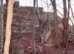 Image 24286 (87k, 660x500) Photo by: Howard Finkel Location: Nature Study Woods-New Rochelle (NYWB Remains) |  Image 24336 (36k, 660x500) Photo by: Howard Finkel Location: Columbus Avenue (NYWB Remains) | 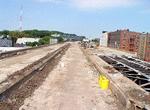 Image 27047 (76k, 640x480) Photo by: Howard Finkel Location: 177th-180th St. (NYWB Remains) |  Image 76401 (97k, 674x516) Photo by: Carlos Fernandez Location: White Plains Greenway (NYWB Remains) |
Photos By Location
Photo locations: 177th-180th St. (NYWB Remains), Kingsbridge Road (NYWB Remains), East 3rd Street/Mount Vernon (NYWB Remains), Columbus Avenue (NYWB Remains), Hutchinson River Viaduct (NYWB Remains), Highbrook Ave./North Pelham (NYWB Remains), Chester Heights (NYWB Remains), Nature Study Woods-New Rochelle (NYWB Remains), Wykagyl (NYWB Remains), Ward School Area (NYWB Remains), 'Pee-Wee Highway' Area (NYWB Remains), Hutchinson River Parkway Area (NYWB Remains), Pine Brook Area (NYWB Remains), Quaker Ridge Area (NYWB Remains), Heathcote Area (NYWB Remains), White Plains Greenway (NYWB Remains), Bryant Avenue (NYWB Remains), Ridgeway Area (NYWB Remains), Gedney-Mamaroneck Area (NYWB Remains), Port Chester (NYWB Remains)
Page Credits
By Howard Finkel.