Montreal, Quebec
![]()
Montréal Métro Green Line station at Place-des-Arts. Photo by David Pirmann, July 2011.
Overview
When did the planning of the métro first begin? While the construction of the métro actually began in 1962, the planning to create it had started all the way back in 1910 when the Montréal Underground and Elevated Railway Co. and the Montréal Street Railway Co. first submitted separate plans to the Quebec Government to create a métro system for Montréal. The Government, due to inadequate funding, denied their plans.
Over the next 50 years, many companies and wealthy individuals would attempt to get the ball rolling to give Montréal a subway, but to no avail. Finally in 1961, the City of Montréal under the tutelage of Mayor Jean Drapeau, created a committee under the control of the City of Montréal Service of Public Works that was chaired by Lucien L'Allier. The committee was called the "Bureau du Métro". The Bureau du Métro would create contracts, prepare blueprints and tend bids for the construction of a métro system in conjunction with the Commission de Transport de Montréal (now the STM) which was the operator of the city's bus system and would operate the new métro system upon it's completion.
When did the construction of the métro begin? In 1961, the initial plans for the network were released which was composed of three lines. Line A (now the #2-Orange) would operate from Crémazie to Place d'Armes. Line B (now the #1-Green) would operate from Atwater to Frontenac. Line C (line 3) would have been a traditional steel wheel to iron rail operation run outdoors. It would have started south of McGill then would have used the tunnel under Mont-Royal, which was owned by CN Rail, and then would have split off into northeast and northwest branches.
Later, it was decided that the #1-Green Line would not run east-west under Rue Sainte-Catherine as originally planned so as to not potentially ruin numerous businesses along the Rue, in addition to creating huge traffic problems within the city. So it was decided that a brand new east-west boulevard would be constructed north of Rue Sainte-Catherine that would require the demolition of numerous buildings of which the new boulevard would run through and the line would then run under the new boulevard, which is today known as Boulevard de Maisonneuve. The official commencement of construction for the new métro began on May 23, 1962.
In 1963 the City of Montréal created important modifications to the initial plan of the métro. The City decided to extend the #2-Orange Line north to Boulevard Henri-Bourassa and south to the Bonaventure station. The City also announced the creation of the #4-Yellow Line from Berri-de Montigny to Longueuil (Rive-Sud). The new #4 line was brought forth directly as a result of Montréal being named as the host of the 1967 World's Fair. Because of the announcement of the World's Fair, plans for the #3 line were abandoned when the City of Montréal decided to put forth it's métro resources towards the construction of the #4-Yellow Line, in addition to the extension of the #2-Orange Line to Henri-Bourassa which would make one of the #3's branches redundant. That is why there is no #3 line when you look at a map of the métro system.
In regards to the World's Fair (Expo 67), the City would choose a rather interesting site for it: two islands facing the City of Montréal in the middle of the Fleuve (River) Saint-Laurent. Problem was, only one island existed at the time being Île Sainte-Hélène. So it was decided to create the second island using the rock and soil which were extracted from the ground during métro construction for the 1 & 2 lines to create the second island: Île Notre-Dame. Originally, there was to be a 4th station along the #4-Yellow Line on the Île Notre-Dame, but that idea was soon nixed.
When did the métro open? The métro commenced operations on Friday October 14, 1966. It cost approximately CDN $213,700,000 to construct these brand new lines and for the purchase of 369 new subway cars. The first trains originally operated on the #1-Green Line between Atwater & Papineau with the Beaudry station being bypassed as it was still under construction. Beaudry would open a couple months later along with the Frontenac station, which also experienced construction delays. The #2-Orange Line operated in its first days between Henri-Bourassa and Place-d'Armes.
Who created the logo for the métro? The logo for the métro (a downward white pointing arrow in a white circle on a blue background) was created by the firm Jacques Guillon and Associates in 1962. This new logo matched with the logo of the CTM (now STM), which is nicknamed the "T-arrow" (a blue T in a blue circle on a white background with a arrow pointing from the T in an eastwardly fashion). The métro logo was approved, but the Mayor had insisted that the word "Métro" be placed underneath the new logo so as to avoid any confusion with the CTM logo.
The "T-arrow" logo was created in 1952 making it one of the longest standing transit logos. It has only been slightly modified within the past 50+ years for modernization. With the original "T-arrow", the circle was formed with the curved words "Commission de Transport de Montréal" on top and "Montréal Transportation Commission" on the bottom. The words were replaced with a solid circle in 1970.
- Approx. daily métro ridership in 2002: 600,000
- Shortest distance between stations: Peel-McGill (#1-Green Line) at 440 m / 0.27 miles
- Longest distance between stations: Berri-UQAM-Jean Drapeau (#4-Yellow Line) at 2.5 km / 1.55 miles
- Deepest station: Charlevoix at 29.6 m / 97.1 feet
- Closest station to surface: Both Angrignon & Longueuil-Université-de-Sherbrooke at 4.3 m / 14.1 feet
- Outside stations: None
- Storage Yards: Angrignon, Beaugrand, Saint-Charles
- Maintenance Barns: Beaugrand, Youville
- Heavy Maintenance (Main) Shop: Youville
Route Map
Track Map
Timeline
- 1861: The Montréal City Passenger Railway Company is founded. It is the first public transport company in Montréal with eight horse-powered trams
- 1892: First tram powered by electricity operates
- 1894: Last horse-powered tram operates
- 1910: First métro projects submitted to the Government
- 1911: Merging of many public transport companies into one company: La Compagnie des Tramways / Montréal Tramways Company
- 1919: First diesel-powered buses arrive
- 1937: Trolleybus service is implemented, the first of its kind in Canada
- 1950: The Compagnie des Tramways is municipalized and eventually becomes the Commission de Transport de Montréal (CTM)
- 1951: CTM begins activities
- 1959: Last tramway operates in Montréal
- 1962: Métro construction begins on May 23 on Rue Berri south of Rue Jarry
- 1963: City of Montréal announces modifications to the métro project
- 1965: Canadian Vickers delivers the first cars to the City of Montréal
- 1966: Métro opens on October 14, last trolleybus is retired from service
- 1967: #2-Orange Line extended to Bonaventure, #4-Yellow Line opens but Ãle Sainte-Hélène station remains closed to the public for an additional 28 days
- 1970: CTM changes name to Commission de Transport de la Communauté Urbaine de Montréal (CTCUM)
- 1971: The "Storm of the Century" hits Montréal on March 3 & 4 which forces the métro to implement 24 hour operation for the first time in its history, a huge fire guts the arriere-gare (relay) at Henri-Bourassa on the #2-Orange Line after a crash occurs which results in the death of a Train Operator and destroys 24 MR-63 cars. The Henri-Bourassa and Sauvé stations receive smoke & water damage as a result.
- 1974: Tire underneath a car catches fire between Rosemont & Laurier on the #2-Orange Line and spreads rapidly. Passengers manage to escape the inferno that destroys 9 MR-63 cars and results in the closure of the #2-Orange Line for a week due to heavy damage, the métro welcomes its 1 billionth passenger
- 1976: #1-Green Line extended to Honoré-Beaugrand, Bombardier delivers first MR-73's, ATO implemented on the #1-Green Line
- 1978: #1-Green Line extended to Angrignon
- 1980: #2-Orange Line extended to Place-Saint-Henri
- 1981: #2-Orange Line extended to Snowdon
- 1982: #2-Orange Line extended to Plamondon, CTCUM takes over operations on the commuter rail lines between Montréal and Deux-Montagnes/Rigaud.
- 1984: #2-Orange Line extended to Du College
- 1985: CTCUM changes name to Société de Transport de la Communauté Urbaine de Montréal (STCUM), color designations are first used to designate métro routes
- 1986: #5-Blue Line opens with service between De Castelnau & Saint-Michel, #2-Orange Line extended to Cote-Vertu
- 1987: #5-Blue Line extended to Parc
- 1988: #5-Blue Line extended to Snowdon
- 1990: AMF is awarded the contract to overhaul the entire remaining MR-63 fleet
- 1996: The newly created Agence Métropolitaine de Transport (AMT) takes over commuter rail operations from the STCUM
- 2000: The métro operates all night for only the second time in its history for the Millennium celebrations on January 1, 2000
- 2002: STCUM changes name to Société de Transport de Montréal (STM)
Operations
Operation of the métro. The métro is an entirely underground operation comprised of 65 stations (with three more under construction on the #2-Orange Line in Laval, north of Henri-Bourassa) served by four lines that cover 60.8 kilometers / 37.8 miles in passenger service (not including sidings, depots, etc.). All platforms within the métro system can handle maximum length 9 car trains. Trains on all lines (except the #4-Yellow) are operated by Automatic Train Operation (ATO) which in a nutshell operates trains by computer from point to point and opens the doors automatically when the train reaches it's proper berth within station limits. Some of the Train Operator's duties include watching over the roadway and staying alert for anything unusual or unsafe that could hinder operation and make an emergency stop if necessary, make proper announcements, and to close the doors after the passengers have boarded and alighted. After the Train Operator has closed the doors, he/she presses a button so as to accelerate the train and depart the station. ATO is available for use on the #4-Yellow Line, but at this time the line is being operated under manual operation. ATO was first implemented on the #1-Green Line in November 1976. Before then, all trains were manually operated.
One Person Train Operation (OPTO), which began in 1986 on the brand new #5-Blue Line, is now utilized on all routes with only one modification. On the #4-Yellow Line, OPTO is also utilized, however all trains are double-ended with one Train Operator (T/O) on each end at all times due to it's very short running time and sometimes odd operational patterns. The T/O on the front end performs all of the required operational duties while the T/O at the non-operational rear end "deadheads". Before the implementation of OPTO, there would be two crewmembers on each train throughout the system. One T/O would be up front to operate the train (and later oversee operations with ATO) and the T/O in the rear would operate the doors and observe the platform. When a train would change directions at a terminal, the duties would then flip-flop.
At terminals, trains are discharged and are then relayed outside the station off of the mainline in what is called the "arrière-gare" which means "behind the station". One unusual relay occurrence occurs on (where else) the #4-Yellow Line. During off-peak hours when the arrière-gare north of the Berri-UQAM station is filled with lay-ups (parked trains), in order for a Yellow Line train to relay, the train after discharging passengers on the Berri-UQAM-bound platform heads south of Berri-UQAM on the mainline tracks and crosses over onto the Longueuil-bound tracks. Then the train wrong-rails back into the Berri-UQAM station on the Longueuil-bound side to pick up passengers and complete the relay. There are no terminals in the Montréal Métro which end with bumping blocks within station limits (like Main Street station on the #7 Line in New York City or O'Hare Airport station on the Blue Line in Chicago for example).
When it is time for a train to depart a terminal, the dispatcher notifies the operator and the public of its impending departure by activating a signal that sounds 6 loud tones, which can be clearly heard throughout the station. Once the last tone has sounded, the operator then begins the process of closing the doors and beginning his/her route.
Roster
How was it decided that the métro would use cars that would run on rubber tires? While on a business trip to Paris, France, Mayor Drapeau was quite impressed with the métro system of Paris that was operated by the Régie autonome des transports parisiens (RATP). The RATP was operating certain lines with trains that ran on rubber tires, which had debuted ten years earlier. After visiting Paris, Mr. Drapeau was so enthralled with the rubber tire concept that he decided to adopt it for the new métro system in Montréal. As a result, the RATP signed with the City of Montréal a "technical assistance contract" that would go into effect once construction began on the new system. The RATP would wind up playing a large role in the construction of Montréal's new subway.
However, the main problem with having a system using rubber tires in lieu of having a traditional steel wheel to iron rail system is that it would have been almost impossible to operate rubber-tired cars in icy and/or snowy conditions. For this reason, construction of the métro in Montréal would have to be exclusively underground, unlike in Paris where adverse conditions of this sort are very rare and where rubber-tired lines do indeed run outdoors. For more information on the rubber-tired system, visit Marc Dufour's page describing the Principle of the Rubber-tired Métro.
The #1-Green line uses MR-63 cars which were built between 1963 and 1967 by Canadian Vickers. Of the 369 cars delivered by Vickers, 33 were destroyed in 1971 and 1974 fires (see timeline). The remaining 336 underwent a general overhaul by AMF between 1990 and 1993. The MR-63's are now used exclusively in #1-Green Line service.
The #2-Orange, #4-Yellow and #5-Blue Lines use MR-73 cars which were constructed by Bombardier between 1974 and 1980. There were 423 cars created under the contract. MR-73's occasionally transfer from line to line with the exception of the #1-Green line. It would not be unusual to see signs in the non-operating positions from the Orange or Blue Lines on a consist being used for Yellow Line service for example.
The only signs that exist on any of the rolling stock are the plates with a metal appearance, which are bracketed on the front and rear of the train inside the operators cab. There are no side signs. Black & white bulkhead roll signs used to exist on the MR-63 cars when they first came out, but were replaced later on with the plates.
Both car classes are linked in 3 car units in an A-B-A fashion. A cars are motor cars with four motors per A car that offer 168 hp per motor (672 hp per A car, 4032 hp per maximum length 9 car train). B cars are totally dependent on the A cars for power and have no motor power whatsoever. In fact, the B cars are so dependent that their trucks don't even have Lateral Pickup Shoes (Contact Shoes).
Looking from the outside, the MR-63's and the MR-73's pretty much have the same exterior look. The interiors of the cars differ with the MR-63's having a gray & white interior while the MR-73's have an orange & white color scheme. Also, the MR-73's possess certain electrical components that were not available in the 1960's when the MR-63's were conceived. One of which were power choppers that release at short intervals the 750 volts DC needed to make the train accelerate from a standing position. These power choppers emit sounds that sound like three musical tones (it sounds like violins) playing when they begin accelerating. This quirky musical trait has actually become one of the unofficial trademarks of the Montréal Métro.
Another feature that the MR-73's would eventually have are interior LED displays that are part of a visual communication network (RCV) that was implemented starting in 1991 by the company Télécité. They show the name of the next station with available bus/subway/commuter rail connections to aid the hearing impaired, advertisements, news highlights, weather, trivia, etc. They also can show pertinent information in the event of an incident within the métro network. Automated announcements also are made with the MR-73's in conjunction with the RCV. Train Operators still have to make manual voice announcements with the MR-63's, which were not equipped with RCV's.
One noticeable missing item with either the MR-63's or MR-73's is the fact that air conditioning does not exist in the métro (the STM bus system also does not offer a/c). MR-63's have an overhead fan system, which looks the same way as the fans on the old NYCTA R-27/R-30's looked, or the old SEPTA M-3 "Almond Joy's". The MR-73's fan system have mainly side vents which blow the air towards the sides of the cars in an effort to improve air circulation within the car. But in this writer's opinion, the MR-63's fans are more efficient. This works in conjunction with a tunnel fan system, which attempt to intake warm air from underground so that the stations, tunnels and rolling stock, while still a bit warm underground during the summer months, usually do not reach unbearably hot temperatures.
- Length from coupler to coupler: 17,200 mm / 56 feet, 5 inches
- Length between car body ends: 16,770 mm / 55 feet, 1 inch
- Power: 750 Volts DC
- Approximate average car weight (empty): 36.1 tons / 72,200 lbs.
- Doorway width: 1,290 mm / 4 feet, 2 inches
- Doorway height: 1,960 mm / 6 feet, 5 inches
- Seats per car (A and B): 40
- Standees (approximate) per car: 125
- Maximum capacity (approximate) for a 9-car train: 1,500
- Maximum allowable speed: 72 kmh / 45 mph
- Maximum train length: 9 cars
- Minimum train length: 3 cars
Ridership
Ridership Statistics. Daily station ridership rankings in 2002 with #1 being the busiest station and #65 having the lightest usage:
| 1 | McGill (Green) | 34 | Viau (Green) |
| 2 | Berri-UQAM (Green, Orange, Yellow) | 35 | Langelier (Green) |
| 3 | Henri-Bourassa (Orange) | 36 | Parc (Blue) |
| 4 | Guy-Concordia (Green) | 37 | Rosemont (Orange) |
| 5 | Longueuil-Université-de-Sherbrooke (Yellow) | 38 | Du College (Orange) |
| 6 | Atwater (Green) | 39 | Université-de-Montréal (Blue) |
| 7 | Peel (Green) | 40 | Cadillac (Green) |
| 8 | Côte-Vertu (Orange) | 41 | Frontenac (Green) |
| 9 | Place-des-Arts (Green) | 42 | De l'Eglise (Orange) |
| 10 | Bonaventure (Orange) | 43 | Place-Saint-Henri (Orange) |
| 11 | Jean-Talon (Orange, Blue) | 44 | Fabre (Blue) |
| 12 | Pie-IX (Green) | 45 | Champ-de-Mars (Orange) |
| 13 | Vendome (Orange) | 46 | Côte-Sainte-Catherine (Orange) |
| 14 | Honoré-Beaugrand (Green) | 47 | Namur (Orange) |
| 15 | Angrignon (Green) | 48 | Jolicoeur (Green) |
| 16 | Place d'Armes (Orange) | 49 | Saint-Laurent (Green) |
| 17 | Mont-Royal (Orange) | 50 | Charlevoix (Green) |
| 18 | Square-Victoria (Orange) | 51 | Verdun (Green) |
| 19 | Crémazie (Orange) | 52 | Jean-Drapeau (Yellow) |
| 20 | Laurier (Orange) | 53 | De Castelnau (Blue) |
| 21 | Sherbrooke (Orange) | 54 | LaSalle (Green) |
| 22 | Saint-Michel (Blue) | 55 | Edouard-Montpetit (Blue) |
| 23 | Lionel-Groulx (Green, Orange) | 56 | Monk (Green) |
| 24 | Sauvé (Orange) | 57 | Outremont (Blue) |
| 25 | Plamondon (Orange) | 58 | Préfontaine (Green) |
| 26 | Beaubien (Orange) | 59 | Beaudry (Green) |
| 27 | Côte-des-Neiges (Blue) | 60 | D'Iberville (Blue) |
| 28 | Radisson (Green) | 61 | Lucien L'Allier (Orange) |
| 29 | Snowdon (Orange, Blue) | 62 | Assomption (Green) |
| 30 | Jarry (Orange) | 63 | Acadie (Blue) |
| 31 | Joliette (Green) | 64 | Georges-Vanier (Orange) |
| 32 | Papineau (Green) | 65 | De la Savane (Orange) |
| 33 | Villa-Maria (Orange) |
Station By Station
Line 1-Green (opened Oct. 14, 1966) Operates between Angrignon and Honoré-Beaugrand for a total of 22.1 km / 13.7 route miles with 27 total stations, an average distance of 850 m / 0.52 miles between stations and takes an average of 37 minutes to complete the route. During rush hours, about 28 trains are utilized in service. 9 car trains are normally operated.
Photo locations: Angrignon, Monk, Jolicoeur, Verdun, De L'Église, LaSalle, Charlevoix, Lionel-Groulx, Atwater, Guy-Concordia, Peel, McGill, Place-des-Arts, Saint-Laurent, Berri-UQAM, Beaudry, Papineau, Frontenac, Préfontaine, Joliette, Pie-IX, Viau, L'Assomption, Cadillac, Langelier, Radisson, Honoré-Beaugrand
Line 2-Orange (opened Oct. 14, 1966) Operates between Côte-Vertu and Henri-Bourassa for a total of 24.8 km / 15.4 route miles with 28 total stations, an average distance of 919 m / 0.57 miles between stations and takes an average of 38 minutes to complete the route. During rush hours, about 28 trains are utilized in service. 9 car trains are normally operated. Construction is currently underway to extend the eastern branch of the line at Henri-Bourassa north into Laval with new stations at Cartier, de la Concorde and the new terminal at Montmorency with completion tentatively scheduled for 2006.
Photo locations: Côte-Vertu, Du Collège, De La Savane, Namur, Plamondon, Côte-Sainte-Catherine, Snowdon, Villa-Maria, Vendôme, Place-Saint-Henri, Lionel-Groulx, Georges-Vanier, Lucien-L'Allier, Bonaventure, Square-Victoria, Place-d'Armes, Champ-de-Mars, Berri-UQAM, Sherbrooke, Mont-Royal, Laurier, Rosemont, Beaubien, Jean-Talon, Jarry, Crémazie, Sauvé, Henri-Bourassa, Cartier, De La Concorde, Montmorency, Youville Depot
Line 4-Yellow (opened Mar. 31, 1967) Operates between Berri-UQAM and Longueuil-Université-de-Sherbrooke for a total of 4.25 km / 2.6 route miles with 3 total stations, an average distance of 2125 m / 1.32 miles between stations (most of which is between Berri-UQAM and Jean Drapeau) and takes an average of 5 minutes to complete the route. During rush hours, 4 trains are operated. Depending on the season and/or when special events are conducted on the Île Sainte-Hélène (Jean Drapeau station), train lengths of 6 or 9 cars are utilized. In the instance when 9 car trains are operated, and the platform barriers that artificially shorten the platform are still in place, access to/from the cars beyond the barriers is gained by swinging the portable door attached to the barrier.
Photo locations: Berri-UQAM, Jean-Drapeau, Longueuil–-Université-de-Sherbrooke
Line 5-Blue (opened Jun. 16, 1986) Operates between Snowdon and Saint-Michel for a total of 9.7 km / 6.02 route miles with 12 total stations, an average distance of 882 m / 0.54 miles between stations and takes an average of 15 minutes to complete the route. During rush hours, about 11 trains are operated. From fall to spring, 6 car trains are utilized during rush hours and 3 car trains during off-peak hours. However during summer months when the universities along the line are on summer break, 3 car trains are operated at all times, including rush hours.
Photo locations: Snowdon, Côte-des-Neiges, Université-de-Montréal, Édouard-Montpetit, Outremont, Acadie, Parc, De Castelnau, Jean-Talon, Fabre, D'Iberville, Saint-Michel
Photo Gallery
| Five Random Images | ||||
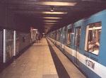 Image 25812 (116k, 1028x743) Photo by: Tristan Zieley Location: Place-d'Armes |  Image 122563 (327k, 1044x701) Photo by: David Pirmann Location: Crémazie |  Image 122564 (294k, 701x1043) Photo by: David Pirmann Location: Crémazie |  Image 122602 (325k, 1044x701) Photo by: David Pirmann Location: Plamondon |  Image 122752 (282k, 1044x701) Photo by: David Pirmann Location: De L'Église |
Links
Official Site of Société de Transport de Montréal
Page Credits
By Tristan Zieley.
Statistics supplied by Société de Transport de Montréal. Information for this article was supplied by the book Le Métro de Montréal, 35 ans déjà, by Benoît Clairoux, published by Èditions Hurtubise HMH of Montréal, Canada. Information used with permission of the author (and with many thanks). For more info on this book: click here.