Mexico City, Mexico
![]()
Mexico City Metro train on Line 4 at Consulado. Photo by Jorge Arturo Monzón Abarca, June 2009.
Overview
Mexico City is one of the biggest cities in the world with a population of approximately 20 million inhabitants. Since 1969 it has been developing a subway system. Now, Mexico City has 11 subway lines with a total length of 201.3 Km (125.8 miles) and 175 stations (106 in subway, 53 at grade, and 16 elevated). All the lines except Line A operate trains with rubber tyres like some lines in Paris and the subways of Montreal and Santiago, Chile. The Mexico City system, as well as those in the Mexican cities of Guadalajara and Monterrey, use symbols, as well as names, for identifying stations.
Also in Mexico City there is a light rail line connecting the subway at the Tasqueña station (line 2) across the southeast of the city to Embarcadero station (Xochimilco), a length of 18.0 km (11.2 miles), with 18 stations all of them at grade. Also currently under construction is a "bus rapid transit," a bus line with independent right of way, along the Avenida Insurgentes crossing the city from north to south. Plans are in place for the construction of a suburban railroad (commuter railroad) in Mexico City from Buenavista to Cuautitlan de Romero Rubio in the northwest suburb of the city, connecting with the subway at Buenavista station (line B) and Ferrería sation (line 6). Buenavista is the former Central passenger railroad station of Mexico City.
On June 1, 2008, a new suburban railroad line began operation from the Buenavista station in Mexico City northwest to Lecheria, a suburb in the "Urban Area" of Mexico City. Known as Ferrocarril Suburbano de la Zona Metropolitana de México (Suburban Railway of the Mexico City Metropolitan Area), its initial line is 18 km long and has 5 stations, and will be extended another 10 km, with 2 additional stations. The stations in operation are as follows: Buenavista (transfer with the Subway Line B Buenavista station and with the BRT Line 1); Fortuna (transfer with the subway Line 6 Ferreria station); Tlalnepantla; San Rafael; Lecheria (provisional terminal). The future stations are: Tultitlan, Cuautitlan. Service is operated every 6 minutes in peak hours and 15 minutes in non-peak hours.
The line was built and operated by the Spanish railroad equipment builder CAF. The trains are "Model 447" EMUs built in Spain, and each train is made up of two units of four cars each. Each car can hold 225 people (seated and standing), with a total capacity per train of 1800 people.
There are plans for further extension of this line from Cuautitlan to Huehuetoca (18 km) and a branch from Lecheria to Xaltocan (19 km).
The Lines
A short description of the subway lines:
| Line | Length | Stations |
|---|---|---|
| 1 | 18.8 Km (11.8 miles) | 20; 19 underground and 1 at grade. |
| 2 | 23.4 Km (14.6 miles) | 24; 14 underground and 10 at grade. |
| 3 | 23.6 Km (14.8 miles) | 21; 17 underground and 4 at grade. |
| 4 | 10.7 Km (6.7 miles) | 10; 2 at grade and 8 elevated. |
| 5 | 15.7 Km (9.8 miles) | 13; 4 underground and 9 at grade. |
| 6 | 13.9 Km (8.7 miles) | 11; 10 underground and 1 at grade. |
| 7 | 18.8 Km (11.8 miles) | 14; 13 underground and 1 at grade. |
| 8 | 20.1 Km (12.6 miles) | 19; 14 underground and 5 at grade. |
| 9 | 15.4 Km (9.6 miles) | 12; 8 underground and 4 elevated. |
| 12 | 24 Km (15 miles) | 20; 9 underground and 11 elevated. |
| A | 17.2 Km (10.8 miles) | 10; 1 underground and 9 at grade. |
| B | 23.7 Km (14.8 miles) | 21; 6 underground, 11 at grade and 4 elevated. |
Route Map

This map image is a file from the Wikimedia Commons. It is in the public domain.
Photo Gallery
| Five Random Images | ||||
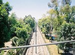 Image 53618 (168k, 820x556) Photo by: Jorge Arturo Monzón Abarca Location: Textitlán | 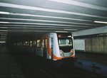 Image 53765 (119k, 820x556) Photo by: Jorge Arturo Monzón Abarca Location: Panteones | 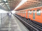 Image 80535 (294k, 1024x768) Photo by: Jorge Arturo Monzón Abarca Location: Oceanía | 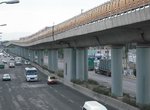 Image 111787 (189k, 1044x788) Photo by: Jorge Arturo Monzón Abarca Location: Ricardo Flores Magón |  Image 114660 (152k, 1044x788) Photo by: Jorge Arturo Monzón Abarca Location: Buenavista |
Photos By Location
L1
Photo locations: Observatorio, Tacubaya, Juanacatlán, Chapultepec, Sevilla, Insurgentes, Cuauhtémoc, Balderas, Salto del Agua, Isabel la Católica, Pino Suárez, Merced, Candelaria, San Lázaro, Moctezuma, Balbuena, Boulevard Puerto Aéreo, Gómez Farías, Zaragoza, Pantitlán, (Misc/Unknown)
L2
Photo locations: Cuatro Caminos, Panteones, Tacuba, Cuitláhuac, Popotla, Colegio Militar, Normal, San Cosme, Revolución, Hidalgo, Bellas Artes, Allende, Zócalo, Pino Suárez, San Antonio Abad, Chabacano, Viaducto, Xola, Villa de Cortés, Nativitas, Portales, Ermita, General Anaya, Tasqueña
L3
Photo locations: Indios Verdes, Deportivo 18 de Marzo, Potrero, La Raza, Tlatelolco, Guerrero, Hidalgo, Juárez, Balderas, Niños Héroes, Hospital General, Centro Médico, Etiopía, Eugenia, División del Norte, Zapata, Coyoacán, Viveros, Miguel Ángel de Quevedo, Copilco, Universidad
L4
Photo locations: Martín Carrera, Talismán, Bondojito, Consulado, Canal del Norte, Morelos, Candelaria, Fray Servando, Jamaica, Santa Anita
L5
Photo locations: Politécnico, Instituto del Petróleo, Autobuses del Norte, La Raza, Misterios, Valle Gómez, Consulado, Eduardo Molina, Aragón, Oceanía, Terminal Aérea, Hangares, Pantitlán
L6
Photo locations: El Rosario, Tezozomoc, Azcapotzalco, Ferrería, Norte 45, Vallejo, Instituto del Petróleo, Lindavista, Deportivo 18 de Marzo, La Villa-Basílica, Martín Carrera
L7
Photo locations: El Rosario, Aquiles Serdán, Camarones, Refinería, Tacuba, San Joaquín, Polanco, Auditorio, Constituyentes, Tacubaya, San Pedro de los Pinos, San Antonio, Mixcoac, Barranca del Muerto
L8
Photo locations: Garibaldi, Bellas Artes, San Juan de Letrán, Salto del Agua, Doctores, Obrera, Chabacano, La Viga, Santa Anita, Coyuya, Iztacalco, Apatlaco, Aculco, Escuadrón 201, Atlatilco, Iztapalapa, Cerro de la Estrella, UAM-I, Constitución de 1917
L9
Photo locations: Tacubaya, Patriotismo, Chilpancingo, Centro Médico, Lázaro Cárdenas, Chabacano, Jamaica, Mixiuhca, Velódromo, Ciudad Deportiva, Puebla, Pantitlán
L12
Photo locations: Mixcoac, Insurgentes Sur, 20 de Noviembre, Zapata, Parque de los Venados, Eje Central, Ermita, Mexicaltzingo, Atlalilco, Culhuacán, San Andres Tomatlan, Lomas Estrella, Calle 11, Periférico Oriente, Tezonco, Olivos, Nopalera, Zapotitlán, Tlaltenco, Tláhuac
LA
Photo locations: Pantitlán, Agrícola Oriental, Canal de San Juan, Tepalcates, Guelatao, Peñón Viejo, Acatitla, Santa Marta, Los Reyes, La Paz
LB
Photo locations: Ciudad Azteca, Plaza Aragón, Olímpica, Tecnológico/Ecatepec, Muzquiz, Río de los Remedios, Impulsora, Nezahualcóyotl, Villa de Aragón, Bosque de Aragón, Deportivo Oceanía, Oceanía, Romero Rubio, Ricardo Flores Magón, San Lázaro, Morelos, Tepito, Lagunilla, Garibaldi, Guerrero, Buenavista
LR L1
Photo locations: Taxqueña, Las Torres, Ciudad Jardín, La Virgen, Xotepingo, Nezahuapilli, Registro Federal, Textitlán, El Virgel, Estadio Azteca, Huipulco, Xomali, Periferico, Tepepan, La Noria, Huichapan, Fco. Goitia, Xochimilco, (Misc/Unknown)
Tren Suburbano
Photo locations: Buenavista, Fortuna, Tlalnepantla, San Rafael, Lecheria, Tultitlan, Cuautitlan, (Misc/Unknown)
Page Credits
By Jorge Arturo Monzón Abarca.