Manchester, England
Overview
The Manchester Metrolink was the UK's first on-street light railway transit system when it was opened by Her Majesty The Queen in 1992. Today two lines are operated, serving 37 route miles and 37 stations, all of which are fully accessible to mobility-impaired people. One line operates from Bury, in north Manchester, through Manchester city centre to Altrincham in south Manchester, and the other from Manchester city centre west to Eccles, which whilst being part of Greater Manchester is part of the City of Salford. Services are run with a fleet of 32 two car, articulated units built by Ansaldo Trasporti in Italy, which are maintained at a depot in north Manchester near to the Woodlands Road stop on the Bury line. Of these, 26 were delivered during 1991 whilst the remainder were purchased in 1999 to provide stock for the new line to Eccles. Further expansion of the system will lead to more new vehicles joinig the fleet over the next few years; Manchester International Airport, Stockport, Rochdale and Ashton-under-Lyne are the next places to be served by Metrolink.
On-street running is the most common practice in Manchester city centre, whilst it also features heavily between Broadway and Ladywell on the Eccles line. Elsewhere the trams run in their own right-of-way, which at certain sections is shared with main-line rail; both the Altrincham and Bury lines were converted from conventional, main-line rail service. Trackage is not shared, however. Trams commonly run as single two-car units although during peak hours it is usual to see two units running together on the Bury and Altrincham lines.
Metrolink runs on a proof-of-payment system whereby all tickets must be pre-purchased at vending machines situated at every station. Also present at every station is a clearly-marked boarding are for disabled people, full frequency and fare guides and loudspeakers connected to the Metrolink Control Room. Ticket inspectors frequently patrol trams, and have become more common recently as a result of passenger feedback. Ridership currently stands at 19 million per year, and is predicted to boom to 50 million per year when the first phase of expansion is completed.
In conclusion, Metrolink is an impressive, efficient light rail system which is of vital importance to several areas of Greater Manchester. Considerable exapansion plans should ensure the system's prosperity for years to come, aided by the impressive reliability of the LRVs in use.
Update- On 20th July 2004, the Transport Secretary Alistair Darling announced to the House of Commons that the planned stage three expansion of the Manchester Metrolink was 'not approved'. This basically meant that it would not go ahead. Stage three was planned to include new lines to Manchester Airport in the south of the city and Ashton-under-Lyne to the east, whilst the Network Rail line to Oldham and Rochdale in north-east Manchester would be converted to Metrolink operation. A second tranche of further expansion was also planned, to include Trafford Park and the Trafford Centre in west Manchester, and East Didsbury and Stockport to the south. A spur off the Eccles line to The Lowry art gallery was also in the pipeline.
Business and local authority leaders in Greater Manchester are campaigning for funding for these projects to be reinstated. To this end, one tram has been 'wrapped' in a purple-based livery to promote the 'Get our Metrolink back on track' campaign whilst most of the other vehicles have this slogan applied liberally throughout. The wrapped tram is one of the three which is able to operate over all three of Metrolink's lines, affording maximum exposure. The well-organised campaign has already presented a 41,500-name petition to Prime Minister Tony Blair and a working party has been set up to attempt to bring the expansion plans 'back on track'.
Station By Station
Unlike the Bury and Altrincham lines, all service from Eccles terminates at Piccadilly Railway Station in central Manchester. This station is situated beneath the main line rail station which offers connections to all parts of the UK. The format of Piccadilly is two side platforms, one of which is used for unloading only whilst the other is used for boarding passengers. After inbound trams have emptied, they run round a small loop to return to the boarding platform. There are two exits from the station, one to Whitworth Street and the other directly to the main line rail station above. Although the Metrolink station is situated beneath the Network Rail terminal, at this moment we are at street level. Once the tram leaves Piccadilly, it proceeds through a small tunnel before emerging onto Piccadilly itself, before crossing the street and running for a short while through a small park, along a dedicated right-of-way. About 10 yards after leaving the tunnel, there is a set of switches to enable trams in both directions to cross tracks. The track then turns right and joins Aytoun Street, again running along its own right-of-way for a short distance before crossing Newton Street and entering the next station.
Immediately after crossing Newton Street, we arrive at the busy Piccadilly Gardens station, which consists of an island platform. As with all Metrolink stops, several ticket vending machines are situated on the platform, along with a 'help point'. Piccadilly Gardens is adjacent to a large bus terminal which is served by all major bus companies in Manchester, some of which offer competing services to stations served by Metrolink. After leaving Piccadilly Gardens the lines split, with those to the right proceeding via the city centre to Bury, and those to the left heading to Altrincham and Eccles. Immediately after turning left onto Mosley Street we arrive at the station of this name; due to space constraints, this stop is served only in the southbound direction. It has one side platform. We then proceed along the street, which is shared with other traffic at this point, for about a half-mile until the tram arrives at St Peters Square, which has two side platforms and is adjacent to both the War Memorial and the main branch of the City of Manchester Public Library. Several bus lines stop by this station.
Immediately after leaving St Peters Square the tram crosses Oxford Street and continues on-street for another 200 yards along Lower Moseley Street. At this point it joins its own right-of-way and climbs a ramp to join an elevated section. The first station along the 'el' is G-MEX, named after the adjacent Greater Manchester Exhibition Centre. The Museum of Science and Industry is also nearby. This station has two offset side platforms, with two exits. One leads to the street, whilst the other leads to a bridge which connects to the Deansgate main line rail station, which is also elevated.
After leaving G-MEX the tram picks up speed rapidly as we head along a viaduct that had lain unused since Manchester Central station closed in 1969, crossing a spur off the Manchester to Liverpool main line before arriving at the next station, Cornbrook. This is an unusual station as it has no access to or from the street; it is merely an interchange only station, being the last stop before the Eccles and Altrincham lines diverge. It is also adjacent to the Manchester to Liverpool main line. The station has one, wide, island platform, and at the north end of the station, an additional small bay platform is present although this is off-limits to passengers and sees no regular service. I suspect this could be a left-over from the period before the construction of Cornbrook, the track that currently lies in the bay platform having previously been part of the main running line. There is an emergency exit at the south end of the platform.
Bury Line
Trams on the Bury line start their journeys at either Altrincham or Piccadilly. The first stop served exclusively by the Bury line is Market Street, probably the most centrally located Metrolink stop. There is one, narrow, island platform in the middle of a pedestrian- and tram-only area. Upon leaving Market Street the tram turns right onto High Street and for a short while shares road space with other traffic. To the left is the Arndale Centre, scene of a huge explosion caused by an IRA bomb on 15th June 1995. We now descend slightly and enter Shudehill station, a newly-constructed facility intended to act as a large interchange with many local bus lines. There are two side platforms, both with ramps ascending to the middle for disabled access. Shudehill opened on 31st March 2003, but construction on the adjacent bus terminal is not expected to be completed until mid-2005.
The tram leaves Shudehill, crosses Dantzic Street and heads along Balloon Street for a short distance. Balloon Street is a dedicated tram-only thoroughfare except for a small area in the middle to facilitate deliveries to the Co-Op Bank's offices. We then cross Corporation Street and enter Victoria, a large station which is shared with Network Rail. Originally, Bury-bound trams served a side platform whilst Altrincham and Piccadilly-bound services stopped at the east face of an island platform, which was staggered from the side platform. Due to debris falling from the station roof, and as a result of this, extremely slippery conditions in wet weather, the side platform has been fenced off and Bury services now call at the west side of the island platform. This is not ideal, as to access the island platform all passengers must cross the Bury-bound track via an open crossing. All tram operators, upon approaching the crossing, seem to have been instructed to stop their LRVs before proceeding with extreme caution.
After departing from Victoria, the tram shares the right-of-way with Network Rail services, although as is the case elsewhere on the Metrolink system, trackage is totally separate. At the narrowest point, the right-of-way consists of six separate tracks. After approximately half a mile, the two Metrolink tracks descend and pass through a short tunnel beneath the Network Rail line before crossing a reasonably high viaduct. The remnants of the right-of-way heading toward Ancoats and Miles Platting can be seen to the right, although the tracks have long been lifted and only a small, overgrown trackbed remains.
To the left is Metrolink's Queens Road depot. A couple of work cars and locomotives are usually visible, but most interesting is an articulated two-piece Boeing LRV unit purchased from San Francisco MUNI which arrived at Queens Road in early 2002. Originally, it had been intended to purchase a number of these units to supplement Metrolink service, but evaluation of the example, which currently languishes in the depot, found they were unsuitable and no further examples followed. The unit retains its MUNI 'wiggly worm' livery and is clearly visible from passing trams, although its future is uncertain. Adjacent to the depot are two tiny platforms, one serving each track, which enable staff access to the facility, and crew changes. When stopping here, only the front set of doors on the unit is able to stop in line with the platform.
After departing from the staff stop the tram crosses access tracks to the depot before arriving at Woodlands Road. As with all stations except Bury on this line, the traces of British Rail heritage are clearly evident, with the two side platforms being accessed via long ramps up from the street. The northern section of the northbound platform is fenced off and out of bounds to passengers. The next stop, Crumpsall, has two wide side platforms with large covered circulation areas by the stairways to the crossover at the north end. The southern halves, and sections to the northern end of of both platforms are fenced off, whilst wheelchair access to the Manchester-bound platform is by either ramp or elevator; no lift is present on the Bury-bound platform, whilst a ramp is currently under construction.
Bowker Vale is similar to Crumpsall, featuring a crossover at the northern end, with both the northern and southern extremities of both platforms out of bounds. Disabled access to both platforms is via ramps. Immediately before arriving at Heaton Park station, the tram passes through a long tunnel beneath Heaton Park itself, Greater Manchester's largest park area which features its own vintage tramway. Heaton Park station is reached immediately after exiting the a further tunnel beneath a road, and consists of two side platforms which are accessed down stairs from the street, with wheelchair access provided by elevators. More than half of both platforms are fenced off to the north, and these areas are somewhat overgrown with weeds.
Prestwich is the next stop, being provided with a large station car park enabling it to act as a Park-and-Ride site for commuters into central Manchester. Prestwich features two side platforms which are accessed by stairs up from a small mezzanine-type area below the middle of the platforms, which is where the ticket machines are located. Disabled access is via two very long ramps. The southern ends of both platforms are both fenced off.
After departing from Prestwich the tram crosses a large, unusually-constructed concrete bridge across the M60 Manchester Ring Road, which at this point is eight lanes of traffic wide. Immediately after crossing the bridge we arrive at Besses O' Th' Barn station, which in contrast to the other seven through stations between Victoria and Bury is made up of a single island platform. Access to the street is down a centrally-located stairway, with disabled access provided by an elevator. Two station buildings exist on the platform but both are locked out of use and would seem to be used as storage facilities. The elevated nature of this station results in a very windswept, uninviting atmosphere which isn't helped by the its somewhat decrepit state. A good view of the Pennine hills is afforded from the east side of the platform.
Whitefield consists of two side platforms, both with the south ends fenced off. Access is via stairs up to the street at the northern end, whilst ramps are present at the southern ends of the in-service platform areas. A small bus interchange is present adjacent to the station, whilst the former station buildings are now occupied by two shops. The next stop, Radcliffe, is situated in a grim, formerly industrial area, and consists of two side platforms which are accessed by stairs from a small mezzanine area below the middle of the platforms. At the south end of the Bury-bound platform there is evidence of the existence of a bay platform to the west, although much of this area is now occupied by a ramp for disabled people. A large car park is present enabling the station to act as a Park-and-Ride site.
After departure from Radcliffe, the tram passes through nearly two miles of rural area, including a grade crossing where the line passes across Withins Lane. Shortly before arrival at Bury, a branch leaves to the west which accesses the preserved East Lancashire Railway's storage yard, although this has not been used for many years. The gate to the ELR's yard is padlocked shut and access would not be possible as regulations state that heavy rail and light rail vehicles may not use the same trackage. From a passing tram it is possible to see part of the ELR's collection of former British Rail rolling stock, although much of it is showing signs of having spent far too long out in the open. Some specimens are arson damaged.
Bury is the northern terminal and consists of an island platform. Whilst both show evidence of regular use it appears that the western platform is favoured. No crew facilities are present. The station is situated beneath Angouleme Way which provides useful shelter from the elements. Access is to the north end, via both escalator and stairway, whilst disabled access is via elevator. These lead to a short walkway which exits into Bury Interchange, a large bus station in which an information office is present. Bury town centre is clearly signed.
The Bury line is served by single-unit articulated trams off-peak, several of which are strengthened to double-units during peak hours. Ridership would appear to justify this capacity provision, with overcrowding a problem even with trams running on a six-minute frequency until early evening Monday to Saturday and every twelve minutes at other times. Unfortunately Metrolink seems to suffer from occasional equipment shortages leading to 'missing' trams, which further exacerbates overcrowding. The 15.9km from Bury to Victoria is covered in 20 minutes, comparing favourably with the well-organised and efficient competing bus service, which takes twice as long to complete the same journey. Unfortunately, as with the Altrincham line, the conversion from British Rail standards appears to have been done as cheaply as possible, leading to several stations looking down-at-heel and decrepit. A dose of weedkiller and lick of paint would not go amiss here, either!
Altrincham Line
The line to Altrincham was the second major section of the Manchester Metrolink to commence public operation, with the section from G-Mex to Altrincham opening on June 15th, 1992. As with the Bury line, most of the right of way is along a former British Rail alignment, with the result that this segment has a more 'heavy-rail' feel to it than the Eccles line. Most of the stations along the Altrincham line are former British Rail facilities, and in some cases only the minimal amount of conversion and adaptation work has been carried out. Currently, service patterns include a 6-minute frequency until early evening Monday to Saturday, with a 12-minute frequency from about 7pm until midnight and all day on Sundays. On Friday and Saturday nights, trams continue running until approximately 0130. Whilst the usual formation is of a single two-car unit, during rush hours and weekends approaching Christmas, it is common to see two two-car units operating together. Passenger loadings would certainly seem to justify this doubling of capacity at busy times. Whilst the vehicles that were modified for use on the Eccles line, and the series 2 cars, can be used on the Altrincham line, in practice this is extremely uncommon and the fleet of 23 unmodified series 1 cars continue to hold down service on the Bury and Altrincham lines, several of which have appeared in a more pleasing, revised livery. For the purpose of this description, Altrincham will be considered south whilst Manchester City Centre/Bury will be considered north.
The section between Manchester City Centre and Cornbrook is covered in the City Center-Shared Stations section. Upon departure from Cornbrook, the line descends and passes beneath the main Network Rail line linking Manchester and Liverpool. The tram rapidly picks up speed and passes along a tree-lined right-of-way, passing through a tunnel immediately before arriving at the first stop served exclusively by Altrincham line trams, Trafford Bar. As with all stations between Cornbrook and Timperley, this station has two side platforms; it is in an open-cut and access is via stairs, with two large double-back ramps provided to enable disabled persons to use the station. The station house is situated at the top of the stairs, on the junction between Talbot Road and Seymour Grove; today its sole purpose is to contain the ticket vending machines. The area surrounding Trafford Bar is somewhat desolate, reflecting the former industrial nature of the area.
Departing from Trafford Bar, the tram continues along the RoW and shortly arrives at Old Trafford, which serves both Lancashire County Cricket Club's Old Trafford ground and Manchester United Football Club's huge Old Trafford stadium, which has a capacity of nearly 70,000 spectators. The traditional scoreboard at the cricket ground is easily visible from the Altrincham-bound platform; United's stadium is approximately a 200 yard walk. As is common with a station serving a large sports arena, the platforms are wide and the station has a large circulation area immediately after passing through the entrance. It is unique on the Altrincham line in being the only station with an underpass as opposed to a crossover; access from the underpass is via staircases, or long ramps for disabled people. Reflecting the former British Rail history of the station, and the low-cost conversion to Metrolink standards, more than half of both platforms to the north end of the station are fenced off and out of bounds to passengers. The remaining sections of both platforms are large enough to accommodate a double-unit train, with a small section of both platforms raised slightly to enable wheelchair users to board the tram.
Upon leaving the station, once again the tram rapidly accelerates, passing a switch soon after departing from Old Trafford. The next stop is Stretford, which again is situated in an open cut and is accessed via stairs or ramps. Transfer can be made here to a non-stop bus to the Trafford Centre, a huge shopping mall which is nearby. The stairs lead to Edge Lane, which is where the station house is situated; this is now used as an office for a taxi company. As with Old Trafford, the northern sections of both platforms are fenced off, with this area of the Manchester-bound platform used to store materials.
The tram then continues via a rural-esque right of way, passing Stretford Cemetery and heading through an area of fields, crossing over the River Mersey and shortly after passing beneath the M60 Manchester Ring Road. We are now operating alongside the Bridgewater Canal, and will continue to do so until shortly after Timperley station. The next station is Dane Road, which is accessed by stairs and two elevators for disabled persons. The former British Rail overbridge is still present, with the entrance at the north end of the station; as a result it is the southern portions of the platforms which are fenced off. As the station is slightly curved, a large mirror is provided to assist the tram's operator when he/she closes the doors.
The next station is Sale, which has disused station buildings on both platforms and a station house, which is used as a crossover and to contain the ticket vending machines. Exit is to Northenden Road, which is part of a bustling town centre, with transfer available to several local bus lines immediately upon exiting the station. Across the street is the imposing Sale Town Hall. Access to both platforms is via stairs; disabled access to the northbound platform is via an elevator, whilst to the southbound platform it is via a ramp.
Upon departure from Sale, it is a straight, fast run to the next station, Brooklands. Immediately before entering the station the tram passes through a small tunnel. Access to the northbound platform is via stairs, or an elevator for the disabled; access to the southbound platform is either via stairs or a ramp across the adjacent car park. The entrance is at the north end of the station; as a result it is the southern section of the platforms which are fenced off. A large shelter is provided on each platform. What looks to be the former station house on the southbound platform has been converted to a traditional-looking public house called 'The Brook', whilst buildings on the northbound platform are disused and in a poor state of repair.
Timperley station is next, which retains a great deal of its traditional British Rail country halt appearance, complete with a large canopy over a section of the northbound platform. Access to the street is again via stairs, with two elevators for the disabled. A street-level station house is disused. Shortly after departing from Timperley, the Bridgewater Canal diverges to the left, and immediately after the two running lines widen out, with a turnback siding being constructed in the middle of the two. Soon after this, the two running lines join together to provide us with a short section of single-track running, which includes Navigation Road station. The reason for this is that the Network Rail line from Stockport joins from the left, which again for a short distance is single-line. We now share the R-o-W with Network Rail, although as with the small section earlier, no trackage is shared. The reason this small length is single-track for both Metrolink and Network Rail is that it would be prohibitively expensive to widen the right-of-way to accommodate four running lines. Also unusual is that it is only the Metrolink line which is electrified, although the overhead line masts span both running lines. Shortly after the change to single-track comes a grade crossing, necessary to cross Deansgate Lane.
We now arrive at Navigation Road station, which is shared with National Rail. Both platforms are bidirectional, with Metrolink serving the western and Network Rail the eastern. Both platforms have the differing signage and platform furniture of their respective companies, creating an unusual look. The Metrolink platform is considerably longer than the Network Rail platform, with the result that the northern section has been fenced off and cannot be accessed by passengers. Immediately after departing the station, the tracks cross another grade crossing, necessary to pass over Navigation Road itself, and shortly after this both tracks widen out to two, creating for a short distance between here and Altrincham a four-track right of way.
We now continue the short distance to the final stop, Altrincham, which is again shared with National Rail. The format for Altrincham is two side platforms and an island; the westernmost side platform and westernmost side of the island platform are served exclusively by Metrolink, with the two eastern platforms being Network Rail property. Whilst Metrolink has two platforms at its disposal, for most of the time the two switches to the north of the station are used and all trams serve platform 1, the side platform which is adjacent to the main entrance to the station; a secondary entrance to the station is at the north end of platform 1. A traditional British Rail overbridge connects all the platforms, situated in the middle of the station. A large poster adjacent to the main entrance states that 'between 7pm and 8pm all Metrolink services will serve the island platform only', the reason for this is to keep the tracks and switches from rusting and ensure they are in operable shape at all times. The station is adjacent to a modern, well-designed bus terminal
In conclusion, the Altrincham line is of vital importance to the areas it serves, demonstrated by the carrying of good passenger loads throughout the day. It represents a huge step change from the previous British Rail service along the route. While pre-Metrolink BR services were regular and frequent (every 15 minutes off-peak, increased in peak), and offered more seated capacity than Metrolink, they started later, and finished earlier (an issue that Metrolink makes much of). They ran to Deansgate, Oxford Road, and Manchester Piccadilly, not through the city centre, as Metrolink does.
Despite this, there is further room for improvement, particularly concerning several of the stations along the line which are somewhat worse for wear and would benefit from cosmetic enhancements - and, in some cases, nothing more than a dose of weedkiller and a fresh coat of paint.
Eccles Line
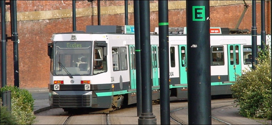
The line to Eccles is the newest portion of the Metrolink system, having opened on July 21, 2000. For this new line, six new two-car articulated light rail vehicles were purchased from Ansaldo in Italy, and numbered 2001-6. To supplement these, three of the original build of 26 units were modified to enable their operation on the Eccles line; the most obvious difference between the modified and the non-modified versions is that the new and modified units have their coupling equipment hidden behind fairings, as only single units may operate on the Eccles line. Whilst modified vehicles may operate on any line, non-modified LRVs may not run to Eccles. This is due to the high percentage of on-street running on the Eccles line; as a result all the series 2 vehicles, and modified series 1 cars, have protective panels across their trucks, whilst the original series 1 vehicles lack these, as the Bury and Altrincham lines have only a small section of street running, in Manchester City Centre. For the benefit of this guide, Manchester will be considered to be North and Eccles to be South.
The Eccles line begins at Manchester Piccadilly Railway Station, and travels south from there through Piccadilly Gardens, St. Peter's Square, G-MEX, and Cornbrook stations, all of which are covered below. After leaving Cornbrook, the lines diverge, with the Altrincham line going to the left and the Eccles line to the right. The north- and south-bound Eccles lines diverge for a short period too, with the southbound line initially diverging to the left before turning right and crossing both Altrincham lines via a flyover. The northbound line, approaching Cornbrook, descends into a section of open-cut before joining the line from Altrincham. We now share the right-of-way with the Manchester to Liverpool main line, although tracks are separate. To the right is a branch of the Manchester Ship canal and soon the tram arrives at the first station served only by the Eccles line, Pomona. This stop consists of an island platform, with access being by three flights of stairs at the north end; disabled access is via an elevator at the south end. A sign at the end of the Eccles-bound platform instructs operators to 'change to street without steps running mode' whilst at the end of the Manchester-bound platform carries the instruction 'change to segregated running mode'. To the south of the platform is a view of Old Trafford, home of Manchester United Football Club.
Immediately after leaving Pomona, the tram makes a very sharp right turn and crosses the Manchester Ship Canal. Shortly after, the line descends to street level and joins its own dedicated right-of-way. Soon we arrive at the Exchange Quay-St James station, which has two side platforms. Once again, Old Trafford is visible to the left, whilst much new development of office space is evident. We cross a minor road and proceed along the right-of-way, which unusually has grass planted across its width.
Soon the tram crosses the major A5063 road and arrives at the next station, Salford Quays. This stop is the first to serve the booming Quays area, and is situated on the waterfront. As we depart, to the left are two rail-mounted cranes, long since disused but which serve as a reminder of the area's past. We climb a small viaduct to pass over a car park before descending back to street level and arriving at Anchorage station. This stop has two side platforms and serves the large Anchorage complex, which consists of office space and hotels.
Upon leaving Anchorage we travel a short distance prior to arriving at Harbour City, which has two side platforms that are offset by approximately 100 yards. This station serves The Lowry art gallery and the Imperial War Museum's Northern annex. Much construction is evident to the left of the tram. We continue along the grass-lined right-of-way for about 50 yards before making a sharp right turn. On the curve there is a tiny spur which diverges to continue ahead for a few yards, whilst another small spur joins as we leave the curve. Perhaps this is evidence of a future plan to create an extension to another terminal.
The next station is Broadway, which has two side platforms. Interestingly, the tracks are spaced very widely at this point, creating the impression that maybe a middle track was originally intended, to bypass the station. After leaving Broadway, we rejoin the street and make good progress as we head along South Langworthy Road. Just before the intersection with Eccles Road we leave the street and join a small section of right-of-way, which contains Langworthy station. This station has two side platforms.
After departure from Langworthy, we return to street running, proceeding down Eccles Road, which is served by several bus lines. About half a mile further down Eccles Road we veer to the right to serve the right-of-way which contains Weaste station, which consists of two side platforms. In stark contrast to the Salford Quays redevelopment, Weaste is a run-down industrial area with many derelict factories; opposite the station is the long-disused former Salford Corporation bus and tram depot.
We rejoin Eccles New Road and travel along the street for approximately a mile before at joining another section of right-of-way before arriving at Ladywell station, which again has two side platforms. Adjacent to the station is a large parking lot, which enables the station to act as a park-&-ride site, both for commuters working in the City Centre and also for Manchester United supporters on match days. Upon leaving Ladywell the line descends sharply and passes through a small tunnel, necessary to avoid a major road junction. The tram then climbs out of the tunnel and proceeds a short distance before arriving at the final station, Eccles. This stop consists of a single side platform; both tracks join together just before arrival at the station. Passengers leave the tram from the right; the tram pauses for a few minutes before returning to Manchester. Eccles station is in the heart of the town centre and is adjacent to a bus terminal, enabling easy transfer to the services of several bus companies. Eccles main line rail station is a five-minute walk, whilst there is also the Eccles Historical Trail nearby. The journey from Piccadilly has taken 29 minutes; trams depart every 12 minutes throughout the day.
Photos By Location
Photo locations: Bury, Radcliffe, Whitefield, Besses o'th' Barn, Prestwich, Heaton Park, Bowker Vale, Crumpsall, Woodlands Road, Victoria, Shudehill, Market Street, Piccadilly, PRW. nr Shepley St., Aytoun St., Piccadilly Gardens, Mosley Street, St. Peter's Square, Deansgate-Castlefield (formerly G-Mex), Cornbrook, Trafford Bar, Old Trafford, Stretford, Dane Road, Sale, Brooklands, Timperley, Navigation Road, Altrincham, Metrolink Shops, Pomona, Exchange Quay, Salford Quays, Anchorage, Harbour City, MediaCityUK, Broadway, Langworthy, Weaste, Ladywell, Eccles, Firswood, Chorlton, St. Werburgh's Road
Photo Gallery
| Five Random Images | ||||
 Image 10283 (91k, 820x553) Photo by: David Pirmann Location: Aytoun St. |  Image 10287 (232k, 1044x788) Photo by: David Pirmann Location: Aytoun St. |  Image 10288 (246k, 1044x788) Photo by: David Pirmann Location: Dane Road |  Image 10309 (96k, 820x553) Photo by: David Pirmann Location: PRW. nr Shepley St. |  Image 10317 (210k, 788x1044) Photo by: David Pirmann Location: St. Peter's Square |
Page Credits
By Tim Deakin.