MUNI T-Third Street Line
![]()
Breda LRV 1520 outbound at 3rd & Channel on the MUNI T-Third Street line. Photo by Peter Ehrlich, November 2008.
Overview
Third Street (originally called Kentucky Street) had streetcar service up to the eve of World War II. Despite the Hunters Point Naval Shipyard reaching peak employment during the hostilities, service through the Bayview was replaced by buses, but the tracks remained in place. Because of this, the Office of Defense Transportaion ordered Market Street Railway Company to restore streetcar service. Muni, which bought out MSRy in 1944, kept streetcars running until 1946.
Following the war, many of the shipyard workers who moved into the Bayview-Hunters Point district from other areas of the United States had set up permanent roots, but the district eventually fell upon economic hard times, seemingly left behind by the rest of the city. Nowhere was this more evident than in the transportation services running to and through the district, which were spotty, to say the least.
Starting in 1989, The City began developing plans to revitalize the Bay View, including transit improvement centered around what was then called the Bayshore Corridor. Passage of Prop. B that year, which levied a half-cent sales tax increase, in 1989 called for fixed-guideway transit improvements in the Bayshore and Geary corridors. The need to redevelop Bay View was considered a more urgent priority. By 1994, Muni had completed a Bayshore Corridor Systems Planning Study, which examined ten scenarios and three routes, and a light rail line was chosen as a locally-preferred alternative by June 1998. Preliminary engineering began in 1996, and the necessary Environmental Impact Reports were ready by early 1999. The Federal Government authorized Muni in mid-1999 to go to Final Design for the Initial Operating Segment, and construction commenced in 2001, divided into eight segments plus separate contracts for station finishing work and a new Metro East Maintenance Facility, which was to be built on the site of the old Western Pacific freight yard at 25th and Illinois.
In order to minimize area disruption, sections within each segment were to be constructed a few blocks at a time. The segments consisted of the 4th Street Bridge (replacement of the existing bascule bridge by DPW); 4th Street to 22nd Street (Mission Bay); 22nd to Jerrold Avenue (Central Waterfront); Jerrold to Donner Avenue (Bayview); Donner to Hester Avenue (Bayview South and US 101 Overcrossing) and Hester to Sunnydale (Visitacion Valley). There was to also be a Sunnydale to Bayshore Caltrain segment, but at the last minute, in a classic case of miscommunication between two government agencies, Caltrain decided to reconfigure Bayshore Station without informing Muni, which would have resulted in a major design change for Muni, so that segment was pulled from the route. It may be built later. As it is, delays and frustration involving contracts for the construction of the new Metro East LRT facility make it unlikely that it will be finished by 2008.
Construction of the $660 million route began in 2001. By 2003, rails were in place on much of the line in Mission Bay, South Bayview and Visitacion Valley segments. The first trackway segment, in Visitacion Valley, was completed in late 2004, and the tracks were tested by Muni's venerable 1917-vintage flatbed motor C-1 (with off-wire operating capability), and were accepted. As of June 2005, overhead wire is in place on the southern three segments (from Third and Jerrold to Visitacion Valley), but the Central Waterfront segment, which crosses Islais Creek on a double-span drawbridge and the Union Pacific Railroad at Cargo Way, is lagging behind. And environmental review problems held up the reinstallation of the 4th Street Bridge, which was finally lowered into place in June 2005.
Original hopes were to open Third Street in 2003, pushed back to November 2005 and then June 2006. Now, the official full-time opening day is April 7, 2007 (see next section for operating plan).
Initial planning for operating the new "T-Third Street" light rail line envisioned through-routing with the J-Church, with the use of single cars. Then it was changed to make the trains run through with the K-Ingleside line. With free weekend demonstration service beginning January 13, 2007, and full-time service commencing April 7, the current plan is to run T-Line trains between Castro Station and Bayshore/Sunnydale. N-Judah trains will terminate at Embarcadero Station, but J-Church trains will be extended to the existing 4th and King/Caltrain Station during rush hours.
Right now, only single-car trains are envisioned. But ultimately, 10-25 more LRVs will be required, and these will have to come from either Breda or another source entirely.
Tying the T-Line into the Muni Metro Subway is the initial operating segment. But preliminary engineering is already beginning in the project to build the new crosstown Central Subway, which will run north of 4th Street on and under that street to Market/Union Square, thence Stockton Street into Clay Street in Chinatown. Then the T-Line will become its own route, and Muni Metro will revert to its old operating plan. If current projections and funding flow holds, Central Subway could open as early as 2012.
Even longer-range plans envision extending the line to Geneva Avenue in Daly City, thence westward across to Balboa Park, which would create a complete circle route for all of Muni's light rail lines.
Station By Station
The T-Third Street route begins at Caltrain/4th and King, where tracks curve southward off King Street (Muni Metro Extension). An island platform, with angled platform canopies, a very tall mast and other features which will be typical of every T-Line station, is reached immediately. Then the tracks cross Mission Creek on the rebuilt draw span of the 4th Street Bridge and curve to the left onto Channel Street to reach Third Street. The trackway is set in alternating pink and gray concrete, which serves as a deterrent to motor vehicle traffic. Note the distinctive light fixtures, with heads reminiscent of pterodactyls.
Out Third Street we go, and there are two alternate side-platform stations in the still-being-developed Mission Bay district-- Mission Rock Street and UCSF-Mission Bay (formerly South Street) stations. Looking north, you can see SBC Park, home of the Giants baseball team. Crossing 16th Street, the line will stop again at Mariposa Street, and we are in a gentrifying warehouse area now, and the Union Iron Works Historic District--where hundreds of ships were constructed during both World Wars and in between--lies on our left side. A loop using 18th, Illinois and 19th Street will be constructed to turn back short-turn trains and possibly E-Embarcadero historic streetcars. The terminal loop of the 22-Fillmore trolley coach line parallels the trackway between 18th and 20th Streets.
Next we come to 20th Street, in the heart of the Dogpatch Historic District, with scattered Victorians interspersed with commercial buildings. Again, this station is alternating side-of-road high level platforms. The aforementioned 22-Fillmore trolley coach line and the 48-Quintara/24th Street bus route exchange passengers here. The giant Continental Can Company factory, now occupied by numerous small business enterprises and artistic organizations, is on the left, between 20th and 22nd Streets. Another station is located at 23rd Street, and two blocks later, on the left, are half-grand union turnouts at 25th and Cesar Chavez Streets which will access the Metro East Light Rail Maintenance Facility. This is followed by a station at Marin Street, which has its platforms setup reverse of normal, with the outbound side north of the inbound platform. Next comes the double drawbridge over Islais Creek, followed by a crossing of the Union Pacific Railroad at Cargo Way. This is one of two LRT/railroad interfaces on this route. The Cargo Way branch is used by trash trains and other services for individual rail customers.
The tracks curve gently into what will now be the Bayview-Hunters Point core corridor and run straight as an arrow for about a mile. Tall, slender palm trees line the center strip between tracks. Following a crossover at Custer Avenue, we reach the station at Evans Avenue, where the Bayview Plaza shopping center is located. The U. S. Postal Service central mail facility is nearby at Evans and Keith. The next stations at Hudson Ave./Innes Ave., Kirkwood Ave./La Salle Ave., Oakdale Ave./Palou Ave. (heart of the Bayview district, sub-named Opera House) and Revere Ave./Shafter Ave. are all island-platform stations, the first ones south of 4th and King. The 24-Divisadero trolley coach line crosses Third Street LRT at Newcomb, after making its terminal stop, and Palou Avenue. Two other bus routes, the 23-Monterey and 44-O'Shaughnessy, cross Third at Palou, with the 54-Felton running alongside, and this station will be one of the busiest on the route.
After Revere, the line makes another gentle right-hand curve, dips downgrade, and continues mostly straight for another mile, making a side-platform stop at Williams Street (formerly Van Dyke Avenue). Already new housing developments are cropping up in anticipation of Third Street LRT. Next comes another curve between Wallace and Yosemite Avenues, followed by the Armstrong Avenue Wye, which juts off to the right, and can hold two 2-car trains. Then we reach a station and the second railroad crossing at Carroll Avenue. Here, the Union Pacific switches freight customers on this railroad branch, which leads into the Naval Base, serving the Golden Gate Railroad Museum, home for the 1921-vintage Southern Pacific P-8 class 4-6-2 2472, which occasionally ventures out for excursions onto the Caltrain main line from which this branch juts off.
Now we reach Gilman/Paul Avenue station, and a transfer with the 29-Sunset. This is the closest station to Monster Park (Candlestick Park) where the 49ers play. The tracks climb up to LeConte Avenue, where an island-platform station is located at the north end of a short cut. The tracks run through this cut and emerge at the overcrossing of the bustling Bayshore Freeway (US 101), where, looking north, you can see the Bank of America Building and other downtown San Francisco office highrises, and drift downgrade to Arleta Avenue station (island platform) and another major bus transfer point, with bus lines 9-San Bruno, 9X-San Bruno Express (which will take over the functions of the 15-Third Street bus on April 7, 2007) and 56-Rutland, and SamTrans route 292. The old Schlage Lock factory, now closed, is on the left. The "Little Hollywood" district and the Executive Park development are out Blanken Avenue, also to the left, and Caltrain's Bayshore Station lies southeast of here. This is the major center in the Visitacion Valley district.
Finally, we reach Sunnydale Avenue station. A trailing crossover is located north of the island platform, and a scissors crossover and two stub tracks are south of the station. Eventually, the tracks will curve left to meet Caltrain at Bayshore Station, but that will now depend on available funding, since the original design ultimately interfered with Caltrain's own plan for that station, and the Bayshore Yard developer's scheme.
This over 6-mile-long LRT is one of the more expensive new light rail routes to construct, at $660 million. But a hefty percentage of this money includes revitalizing several neighborhoods, and one can't really put a price on that. Even a year before its opening, many new apartment buildings and businesses have opened along the entire route.
Photo Gallery
| Five Random Images | ||||
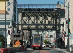 Image 56491 (228k, 864x553) Photo by: Peter Ehrlich Location: 4th Street Drawbridge | 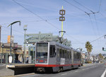 Image 80958 (163k, 864x574) Photo by: Peter Ehrlich Location: Oakdale Ave./Palou Ave. |  Image 85676 (188k, 864x574) Photo by: Peter Ehrlich Location: MetroEast Rail Maint Facility |  Image 91325 (182k, 864x574) Photo by: Peter Ehrlich Location: MetroEast Rail Maint Facility | 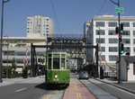 Image 101714 (198k, 930x618) Photo by: Peter Ehrlich Location: Channel/4th |
Photos By Location
Photo locations: Chinatown, Union Square, Market/Mission Streets, Folsom Street, 3rd Street Portals, Connection to Muni Metro Extension, 4th & King, Caltrain/4th & King, 4th Street/Berry, 4th Street Drawbridge, Channel/4th, Channel Street (between 4th & 3rd), Channel/3rd, Mission Rock St., Bet. Mission Rock & South St., UCSF/Mission Bay, 3rd Street/16th Street, Mariposa St., 18th St. (Loop), Illinois Street (Loop), 19th St. (Loop), 20th St., 3rd Street/Between 20th and 22nd, 3rd Street/22nd Street, 23rd St., 3rd Street/24th Street, 3rd Street/25th St. (Turnout), 25th Street/4th Street (Yard Access), 25th Street/Illinois (Yard Access), MetroEast Rail Maint Facility, 3rd Street/Cesar Chavez St. (Turnout), Marin St., Islais Creek Drawbridge, Union Pacific RR Crossing/Cargo Way, Custer Ave. Crossover, Evans Ave., 3rd Street/Galvez, Hudson Ave./Innes Ave., 3rd Street/Innes Ave., 3rd Street/Jerrold Ave, Kirkwood Ave./La Salle Ave., 3rd Street/LaSalle Ave., 3rd Street/McKinnon, 3rd Street/Newcomb Ave., Oakdale Ave./Palou Ave., Revere Ave./Shafter Ave., 3rd Street/Shafter Street, 3rd Street/Thornton/Thomas, 3rd Street/Underwood, Williams Avenue, 3rd Street/Wallace Ave., 3rd Street/Yosemite Ave., 3rd Street/Armstrong Ave. Wye, Carroll Ave., Union Pacific RR Crossing/Carroll Ave., 3rd Street/Donner Ave, 3rd Street/Egbert Ave, 3rd Street/Fitzgerald, Gilman Ave./Paul Ave., 3rd Street/Hollister Ave, 3rd Street/Ingerson Ave., 3rd Street/Jamestown Ave., 3rd Street/Key Ave., Le Conte Ave., South of Le Conte Ave., Crossing Bayshore Blvd./Freeway, Bayshore Blvd./Hester/Lois, Bayshore Blvd./Tunnel Ave., Bayshore Blvd./Blanken, Arleta Avenue, Bayshore Blvd./Raymond Ave., Bayshore Blvd./Leland Ave., Bayshore Blvd./Vistacion Ave., Sunnydale Ave., Crossovers south of Sunnydale Station, Caltrain/Bayshore, (Misc/Unknown)
Page Credits
By Peter Ehrlich.