MBTA Blue Line
![]()
MBTA Blue Line train at Orient Heights. Photo by S.L. Peters, 2007.
Overview
The Blue Line is the shortest line on the MBTA and is the only MBTA rapid transit line to terminate in downtown Boston. The current Blue Line got its start in two different ways. The tunnel portions started out as a streetcar tunnel, like the Green Line, from downtown Boston, under the harbor, to East Boston. It allowed East Boston trolley lines to connect directly into downtown without the need for ferries. In the mid 1920's, the tunnel was converted to heavy rail subway operation, operating from Bowdoin to Maverick Square.
The surface portion of the line out to Revere began life as the narrow gauge Boston, Revere Beach and Lynn Railroad. It ran from Lynn, along the coast to Orient Heights. From there, passengers could change to trolleys or ride a ferry across Boston Harbor. The BRB&L operated until the mid-1940s when it went under. The line sat unused until the 1950s when it was converted to standard gauge rapid transit operation and connected to the tunnel line in East Boston, creating the Blue Line as we know it today.
The downtown subway and East Boston tunnel use third rail for current collection. The third rail extends to Airport station from which catenary overhead wire powers the line out to Revere. At Airport the trains switch from third rail to pantograph operation while stopped in the station.
There have been discussions on how to extend the Blue Line beyond its current terminals. The Blue Line has not seen any extensions since the 1950's Revere Beach line. There has been proposals to extend the northern route beyond Wonderland, into Lynn and beyond. There have been several different approaches on how to do this. One idea would use old narrow gauge right of way. One big problem would be bridging the Saugus River. Another would be to branch off somewhere, and follow the MBTA / B&M commuter line. Recently there has been other proposals to re route the very last leg of the Blue Line to meet with a proposed Revere commuter rail station on the existing north shore line. One of these ideas even closes the Wonderland stop in favor of heading west from Revere Beach.
Other ideas include linking the Blue Line and commuter rail with some sort of people mover, busway, moving sidewalk, or other alternative.
The MBTA has looked at several options for the connections to Logan Airport. Currently, shuttle busses make the rounds from the Blue Line. There has been several ideas including an automated people mover, to even closing the Airport stop, and making connections from a nearby station.
Another proposal is to extend the subway from Bowdoin, to the Charles MGH station on the Red Line. This would link the Red and Blue lines, the only two MBTA lines that do not cross. Currently all of these ideas for the Blue Line are just discussion, and proposed studies.
Route Map
Historical Blue Line Route Map. Route map designed by Gerry O'Regan (PDF Format).
Track Map
Station By Station


We will start our tour in Bowdoin station just west of the center of downtown Boston. Bowdoin opened on March 16, 1916. It features a center platform in the east half of an underground balloon loop track. Inbound trains stop, then head west, though a sharp turn loop just west of the station platform. They emerge at the outbound side of the platform, ready to head to Revere. Just west of the Bowdoin loop are two stub end tracks for storage. When the line was still operated by trolleys, these tail tracks extended beyond Bowdoin to a portal at Cambridge and Russell Streets, and thence across the Longfellow Bridge. The portal was sealed on October 23, 1952 but probably had not seen service since the 1920s conversion of the line to rapid transit operation. From time to time, talk arises about extending the Blue Line westward through these tunnels to western parts of Boston or Cambridge. If this were to happen, Bowdoin station would probably be demolished and rebuilt since it is not able to be enlarged at its present location to accommodate 6 car trains. Bowdoin station is currently used only during rush hours; it is very close to the Government Center stop, and passengers can walk to areas around Bowdoin from that station.
Heading due southeast, then east through the subway the next stop is Government Center. Also opened on March 16, 1916, this station has a center island platform and allows transfer to the MBTA Green Line. Formerly known as Scollay Under, there are signs at the far ends of the platforms on the trackside walls still reading "Scollay Under". The far east and west ends of the platforms had been closed off, but as the Blue Line is being reconfigured to accommodate six car trains, these closed areas are being reopened.
Between Government Center and State, the line passes under the location of its former terminal station at Court Street. Court Street opened along with the original portion of the tunnel line on December 30, 1904 and is adjacent to the Green Line station at Government Center (formerly Scollay Square). It was closed on or around March 16, 1916 when the extension to Bowdoin was opened. The new tunnel from Bowdoin was at a lower level, in order to pass under the Tremont Street Subway at Scollay Square. To connect the old and "new" portions, the trackways at Court St. were converted to ramps. In the 1980s, the platform space has been converted into a ventilation room, best seen from the Green Line station at Government Center.
The next stop is State. This station has two platforms across from each other. At State, persons can transfer to the MBTA Orange Line on the upper level. A closed exit leading directly into the Exchange Building is on the eastbound platform.
Leaving State, the Blue Line heads east and rolls into Aquarium. This is the deepest of all the MBTA subway stations and is the last station in Boston before crossing under the harbor. Also configured with two side platforms, the station is in a deep bore tunnel. The tunnel line's heritage as a streetcar subway are quite obvious at both State and Aquarium, where the stations are quite a bit smaller than one would expect for a rapid transit heavy rail subway.
Heading out of Aquarium, the Blue Line heads east, then turns slightly northeast, and descends under Boston Harbor. This tunnel was the first under Boston Harbor, and also the first underwater tunnel of its type in the US. This is also the deepest subway line on the system, and grades are noticeable. The line climbs back up, and under East Boston, to the Maverick station, a center island station and the last one in the subway section of the line. An area for streetcars to load and unload was provided here until 1952, and a turning loop for these cars is just west of the platforms. An incline for the streetcars to reach the street is now used as space for escalators to the surface.
Now heading northeast, the line departs the subway and enters Airport station. This station has two side platforms, and the area is surrounded by highway overpasses. Though not right at the airport, the MBTA provides a free shuttle bus to each terminal from here. In 2004 a new station opened, slightly east of the original, which (as you can tell from the photos) is quite different from any other MBTA rapid transit station. This station is where trains transfer from third rail to overhead wire. You can stand on the platforms, and watch the pantographs rise up and contact the catenary. During the switch, ventilation and lighting systems on the train are temporarily disrupted.
Rolling northeast, there is a small tunnel to allow a Boston & Maine rail spur to cross over. Exiting the tunnel the Blue Line crosses over a short elevated structure as it rolls into the next stop, Wood Island. This and most of the remaining stations have all recently been rebuilt (with the exception of Orient Heights). This station, and all others remaining have two side platforms, one each for serving inbound and outbound trains.
Continuing northeastward through residential East Boston, the Blue Line approaches Orient Heights. Just past this station, on the east side, is the Orient Hights rail yard, tower, and shops. Several sets of switches allow trains from either direction can access the yard.
Continuing northeastward through residential East Boston, the Blue Line approaches Orient Heights. Just past this station, on the east side, is the Orient Hights rail yard, tower, and shops. Several sets of switches allow trains from either direction can access the yard.
The next stop is Suffolk Downs, across from a horse track of the same name. In the late 1970's the outbound platform burned, and for a while, until funds were found, you had to ride out to the next stop, change, and ride back to get off here. Now the station is back in service, and is popular among horse racing fans.
Rolling northeast, the line passes under many streets on bridges. At one time, in the narrow gauge days, grade crossings were present. But today there are none. The next stop is Beachmont.
Northeastward, then turning northward, the Blue Line ducts under a highway, and heads across some open land. Approaching Revere the line runs along side some newly built condos, and enters Revere Beach station. This stop is in a depressed right of way, and is about 2 blocks from the ocean. At one time a large amusement park existed here. Now, the condos have taken over, adding more changes to the beachfront community. It should be noted that trolley tracks from years ago can still be seen embedded in local streets in this area.
Leaving here, the Blue Line turns northeast again, and arrives at Wonderland, named for the nearby dog track. This is the current end of the line. There are several storage tracks beyond the station, trains usually use these to transfer from the outbound to inbound tracks.
Roster
The Blue Line has seen several types of cars in the existence of the Revere Extension. Because the route is a former narrow gauge line, and the tunnel was originally designed for streetcars, Blue Line cars were designed smaller and shorter. The first series of cars were the 0500 series PCC designed cars. These were another heavy rail PCC car and ran from the begining of the Revere extension, to 1979. These cars, built by Pullman - Standard were smaller than the traditional heavy rail car. They also featured the one person cab, that allowed for viewing out the front of the train.
From 1979 to 2011 service on the Blue Line was operated by the "0600" series, built by Hawker Siddely. These cars were based on the designs of the PA-3 fleet that Hawker-Siddely built for the PATH system in 1972.
Beginning in 2007, the fleet was replaced with the "0700" series, 94 stainless steel cars built by Siemens. The cars are 48 feet long and 9 feet 3 inches wide, stainless steel, and have two pairs of doors per side. These cars now provide the entirety of service on the Blue Line.
Photo Gallery
| Five Random Images | ||||
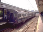 Image 18337 (185k, 1024x689) Photo by: Steve Zabel Collection of: Joe Testagrose Location: Orient Heights | 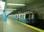 Image 32101 (166k, 1044x788) Photo by: Richard Panse Location: Maverick | 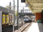 Image 84356 (209k, 864x574) Photo by: Peter Ehrlich Location: Orient Heights |  Image 89292 (222k, 1044x706) Photo by: Richard Panse Location: Beachmont | 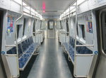 Image 144362 (301k, 1044x788) Photo by: Bernard Chatreau |
Photos By Location
Photo locations: Bowdoin, Government Center, State, Aquarium, Maverick, Airport, Bet. Wood Island & Airport, Wood Island, Bet. Wood Island & Orient Heights, Orient Heights, Orient Heights Yard, Suffolk Downs, Beachmont, Bet. Beachmont & Revere Beach, Revere Beach, Bet. Revere Beach & Wonderland, Wonderland, (Misc/Unknown)
Related Documents
East Boston Tunnel News (1923-1928). Electric Railway Journal news items about the East Boston Tunnel line. New Cars for East Boston Tunnel. Reducing Weight of Rapid Transit Cars Saves $108,000 a Year. East Boston Tunnel Changed Over to Train Operation. Narrow Gage Boston, Revere Beach & Lynn Electrified for Economy.
Page Credits
By Gerry O'Regan.