LAMTA Gold Line
![]()
Los Angeles Gold Line LRV stops at Memorial Park, September 2003. Photo by Salaam Allah.
Overview
The $740 million, 14-mile Pasadena Gold Line, Los Angeles' fourth rail transit service (not counting Metrolink), began revenue operation on July 26, 2003. For the most part, the route covers the old Santa Fe Railway Pasadena Subdivision, where such famed name trains as the Super Chief and El Capitan once strode, and, until it moved to the Santa Ana Canyon route, Amtrak's Southwest Chief. The right-of-way is still evident throughout.
Route Map

The Gold Line Fleet
The LRVs used on the Gold Line are 26 of the 52 locally-assembled Siemens P2000, which were built between 1996 and 1999, but did not actually enter service until this year. The cars are numbered 227-250, plus 301 and 302 (these had been considered for some kind of automated operation, but equipment for such was never installed and which will not happen on the Pasadena Gold Line). They are identical to the units in service on the Norwalk-Redondo Beach Green Line. Service is every 10 minutes during peak times, 12 minutes during the day, and 20 minutes at night. Weekend daytime trains operate every 12 minutes apart. Fares are $1.35, with a surcharge for transferring to buses or the Red Line at Union Station.
The Pasadena Gold Line is physically isolated from the other MTA light rail transit lines in the Los Angeles Basin, and the cars had to be trucked over from the Blue Line Del Amo shops. While the facility near Broadway and the Los Angeles River handles most maintenance, heavy overhauls must also be performed at Del Amo.
The Future
A 6-mile extension eastward from Union Station into the Boyle Heights and East Los Angeles districts is now lining up funding, and has passed its Environmental review. Construction is expected to begin soon. The LACMTA (Los Angeles County Metropolitan Transportation Authority) also wants to extend the line eastward from Sierra Madre Villa as far as Claremont. That is unlikely to occur for about 10 years, because of funding constraints and the need to start lines such as the Exposition Line to Santa Monica. But for now, the public can ride clean, frequent trains through some of the Los Angeles Basin's most historic and scenic districts and towns.
Station By Station
Original Line to Sierra Madre Villa
Our route begins at Union Station, where Gold Line trains serve the complex on Tracks 1 and 2, which had been pulled up during the reconstruction of the landmark station in the 1980s. Here connections are made to the Metrolink Commuter Rail services to Ventura County, Antelope Valley, Orange County, San Bernardino and Riverside; Amtrak Pacific Surfliner, Coast Starlight, Southwest Chief and Sunset trains to all points north, east, south and southwest; bus connections to Bakersfield; and LAMTA Red Line subway, serving downtown L.A., Wilshire Blvd., the north Vermont Avenue corridor, Hollywood, Universal City and North Hollywood. An island platform is located here. Both tracks extend south to the walkway and gap trains are sometimes stored here. Escalators and elevators descend to the subterranean walkway connecting with the station, other trains and the new Metro Center office tower for the Los Angeles County Transportation Authority (LACMTA). Although the platform can handle three-car trains, currently trains consist of two cars maximum.
Leaving Union Station, the line ramps up onto an elevated structure--the only such alignment on the entire system--crossing over tracks for private car storage and across busy Alameda Street to the spectacular center-platform Chinatown station, shaped in Chinese-style architecture to complement the neighborhood. The rider has quite a panoply of views here--downtown L. A. highrises on the left, the Union Station complex and its approach from the Los Angeles River on the right. Departing eastward from Chinatown the trains descend from the elevated structure and pass an area known as the "Cornfields", site of former railroad yards primed for future development, and then pass under the Buena Vista Bridge.
Coming to the Los Angeles River and the Buena Vista Viaduct, a set of tracks branch off to the Gold Line's yard and maintenance facility on the west bank of the river. There is a rail connection here from the Metrolink tracks (but since there is no connection from there to the rest of the Los Angeles light rail system, the Gold Line cars were trucked in).
Crossing the river on a new structure (which replaced a former structure used by ATSF and Amtrak), the Gold Line crosses the Metrolink and Amtrak right of way on the left bank, and a Union Pacific freight right of way on the right bank.
Here the line enters the Santa Fe right-of-way and approaches Lincoln Heights/Cypress Park station, which has side platforms. Most of the line's stations sport the style of station canopies such as those used here. After departing Lincoln Heights, a grade crossing at Avenue 33 provides good photo opportunities.
Next, after crossing the tumultuous Pasadena Freeway, comes Heritage Square/Arroyo station, also with side platforms. Many girder bridges, including the ones here dating from Santa Fe days were retained by the Pasadena Line Construction Authority, builder of the new line.
Following Heritage Square/Arroyo, the line ducks through a short tunnel and emerges again into a more hilly terrain along the edge of Mt. Washington, pausing to serve Southwest Museum station. The museum, with an extensive collection of archival treasures and art of the American Indian, Spanish Colonial and Western American cultures, resides on a steep hill above the station. The island platform features "tree canopies" at its west end and ceramic heads on pedestals depicting royalty, as part of the artwork adorning the station site. Inbound trains are required to come to a full stop at the end of the curve entering the station.
Skirting the hillside on the north, the line then crosses an arroyo and enters Marmion Way, where several blocks of restricted-speed (to 20mph) operation brings the line to island-platform Highland Park station, centerpiece of a lively middle-class mostly Hispanic neighborhood. Departing Highland Park, the line crosses the Arroyo River, a park, and Freeway 110 on a bridge formerly used by ATSF and Amtrak.
After leaving Highland Park, the route crosses busy North Figueroa Street and curves over a high trestle crossing Pasadena Avenue into South Pasadena and the most controversial segment of the route. Indeed, residents here are angry over the constant bells on the numerous crossing gates and the Amtrak horns (actually recordings) which are blared by the trains, and "No Bells/No Horns, Train Speeds to 20mph" protest signs line the right-of-way. The trains, traveling at 50mph make a stop in the center of town, at Mission station, with side platforms and a six-point crossing at the east end with Mission Street, Meridian Avenue and the right-of-way. Mission station is in the heart of South Pasadena. The tracks comprise a six-pointed star along with Mission Street. and Meridian Avenue.
After Mission, fast running resumes, and the tracks roll through a bucolic neighborhood before reaching a power plant, where the tracks curve northward straight into Pasadena. Before reaching the next station, the line passes under the Oaklawn Bridge, a WWI-era bridge formerly used by cars, but now only by pedestrians and cyclists. Located on South Fair Oaks Drive in South Pasadena, and despite the speed of the trains, the bridge makes a good photo location off the beaten path. Another bridge location is at Fair Oaks Avenue itself, offering good southbound views of the line. The next station is Fillmore, with an island platform.
Next up is Del Mar, with side platforms. The original Pasadena Santa Fe depot is visible just beyond the north end of the Del Mar station, as are the cupola of the famous Green Hotel, which has been restored and converted to condominiums. Extensive development is being carried out around Del Mar station, which will make this stop the centerpiece of a transit village. A short distance to the north is the south portal of the tunnel which will emerge at our next station, Memorial Park. Views from the above the tunnel portal can be had parking lots off nearby Green Street.
North of Del Mar, the route ducks into a long subway before reaching Memorial Park station, the only partially submerged station on the route. Historic Old Pasadena and its landmark City Hall (which has been depicted in movies and TV shows such as Mission: Impossible) are just steps away from the station. The original Santa Fe alignment is visible south of Memorial Park (and above the subway). Memorial Park, along with Chinatown and Southwest Museum, is easily the most spectacular station on the entire Gold Line. It's a side-platform station, and a hanging sculpture comprised of metal shapes is mounted above the east platform.
Departing Memorial Park, trains continue under cover, turning eastward to the portal where the right-of-way emerges into the median of the Foothill Freeway. There are three stations here: Lake Avenue, Allen, and the present terminal, Sierra Madre Villa. Needless to say, all are island platforms. While riding eastbound trains in the afternoon, watch for the train zooming past stalled traffic--a great selling point for rail transit in general.
Photo Gallery
| Five Random Images | ||||
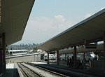 Image 26765 (56k, 720x478) Photo by: Peter Ehrlich Location: Union Station |  Image 34478 (163k, 896x592) Photo by: Kenneth Mosinski |  Image 107363 (193k, 930x618) Photo by: Peter Ehrlich Location: Pico/Aliso |  Image 107420 (221k, 930x614) Photo by: Peter Ehrlich Location: Pico/Aliso | 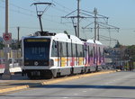 Image 118361 (185k, 800x600) Photo by: Salaam Allah Location: E. 1st Street Bridge |
Photos By Location
Photo locations: Atlantic, E. 3rd Street/E. Beverly, East L.A. Civic Center, Maravilla, E. 3rd Street/Serbian Cemetery, E. 3rd Street/Sanctuary of Lady Guadalupe, E. 3rd Street/Pomona Freeway, E. 3rd Street/Herbert, E. 3rd Street/Indiana, Indiana, E. 1st Street/Indiana, Boyle Heights Subway East Portal (E. 1st/Lorena), Soto, Mariachi Plaza, Boyle Heights Subway West Portal (E. 1st/Gless), Pico/Aliso, E. 1st Street/Mission, E. 1st Street Bridge, E. 1st Street/Garey, E. 1st Street/Hewitt, Little Tokyo/Arts District, Alameda Street Viaduct, Union Station, Chinatown, East of Chinatown, Los Angeles River Bridge, Gold Line Shops/Yard, Lincoln Heights/Cypress Park, Avenue 33 Grade Crossing, Heritage Square/Arroyo, Southwest Museum, Marmion Way, Highland Park, Arroyo River Bridge, South Pasadena (Mission), Oaklawn Bridge, Fair Oaks Bridge, Glen Arm Crossing, Fillmore, Del Mar, Memorial Park, Foothill Freeway Portal (Los Robles Ave), Lake Avenue, Allen, Sierra Madre Villa
Page Credits
By Peter Ehrlich and Salaam Allah. Map by Michael Calcacgno.