Cleveland, Ohio
![]()
GCRTA LRV on the Waterfront Line, September 2001. Photo by Brian Weinberg.
Overview
The rail transit system in Cleveland today has its antecedents in real estate development of the early 20th Century. Two brothers, O. P. and M. E. Van Sweringen had acquired land southeast of downtown which they turned into the city of Shaker Heights. As their residents were likely to work in the central area of Cleveland, they sought to construct a rapid transit line, which have become the Blue and Green lines of the Greater Cleveland Rapid Transit Authority. The first section opened in 1913.
The construction of the Shaker Heights Rapid Transit line into Cleveland resulted in a right-of-way dispute with the NYC&STL Railway (Nickel Plate Road), ultimately settled when the Vans bought the railroad. This purchase in turn contributed to their later projects: building Public Square, the Terminal Tower, and the Union Terminal in downtown Cleveland. This massive project gathered most of the passenger trains into a single station, and like the Grand Central project in New York included electrification to eliminate smoke from steam engines in downtown area, as well as a department store, hotel, and office tower on the air rights. In the grand design provision was made for several rapid transit lines to enter the terminal area, but due to disputes with city politicians and the depression, only the Shaker Heights line existed until the 1950's.
As the Cleveland streetcar system turned into a bus system under public operation, plans again were drawn up for a city subway system. The resulting line (now known as the Red Line) opened for riders on 15 March, 1955 on the route from Union Terminal to the Windermere Station on the East Side. The initial portion of the line was 7.8 miles long including 2.6 miles of shared trackage with the Shaker Heights line, which was converted into a section of mixed high and low level platforms operated "left hand running" to accommodate PCCs.
The route was extended to the West Side of Cleveland in stages; the 5.3 miles to West 117th opened on 15 August 1955, with 1.8 further miles to West Park on 15 November 1958. In 1968, 4 more miles opened bringing the line directly into the terminal at Hopkins Airport.
Most of the line is either at grade, in a cut or on an embankment and directly adjacent mainline railroad rights of way (in New York terms think of the Sea Beach/Bay Ridge Branch of the New York Connecting RR). In some sections the original RR was moved laterally to accommodate the rapid transit line and in others cases, flyovers were built to facilitate continued freight access to industrial customers.
When originally opened, the CTS or "Rapid" had an 88 car fleet of single and married pair cars built by St Louis Car Co. The entire system is overhead catenary much like the Blue Line in Boston, but with the oddity of mixed platform height on the joint use section. The early cars had two sliding door sets and were 48'6" long. Concurrent with the Airport extension a second class of cars were delivered. These are the cars with the slanted end panels in the accompanying pictures. Both of these fleets have been retired with the 1982 delivery of 60 stainless steel cars manufactured by Sumitomo. The basic design remains two doors per car, very close to the ends of the cars, in a high platform rapid transit style. Fare collection is on board during off hours at some stations.
The Shaker system was originally staffed with Peter Witt cars (Peter Witt was a native of Cleveland and the style of trolleycar named for him originated here), of which one is retained for occasional charter use, but for many years the system was home to a large fleet of MU equipped PCCs. These have been retired with purchase of 48 Breda-built LRVs in the 1980s. The Breda cars, which have doors on both sides, have allowed right hand running on the joint trackage, however it is still the case that in this section each station has dual platforms to accommodate both the high level and low level entry cars.
When the Rapid opened a shops facility was built at the Windermere Terminal, but with the 1980s car purchases a new shop at East 55th Street now maintains both fleets. The previous nearby Shaker Heights Shop was then closed.
Route Map

Station By Station
Red Line
Let us begin our tour at the Hopkins Airport station. Stepping away from the baggage area, the Red Line Station is inside the terminal building, completely out of the weather. Paying one's fare at the booth, one enters onto an island platform. From here trains leave for the east end of the line from 5AM to 1AM. During closed periods buses provide limited service. At present most trains make all stops as the system is two tracks only.
Leaving the Airport the line comes to grade level and joins the right of way of the former New York Central heading northeasterly. On our left is a storage yard where the 2nd fleet of rapid transit cars were stored for several years. Brookpark and West 150th St.-Puritas are the next two stations, both have island platforms. Each includes bus transfer facilities and parking.
West Park, the next station, was the terminal of the line until 1968 and some layup sidings remain adjacent to the island platform. From here toward downtown the line parallels the Nickel Plate (now Norfolk Southern) right of way, making stops at Triskett, West 117th St.-Madison, West 98th St.-Detroit (West Blvd.), and West 65th St.-Madison are each island platform stations along this right of way. West 25th St-Ohio City is next and was the location of a small maintenance of way yard to the south of the station.
The line now crosses the the Cuyahoga River and enters the Tower City (formerly Union Terminal) area on the railroad-built bridge/embankment structure. Just as the line enters the complex it is joined by the tracks of the 1995 Waterfront Extension of the Green and Blue LRV lines (see below). Tower City-Public Square, as it is now called, is the renovated Terminal Tower development mentioned above. While the inter-city trains no longer pass through, the transit lines converge here and the former station has been turned into an urban mall with multiplex movies and the predictable Gap, chocolate chip cookies, and chain music stores. The original transit trackage and platforms have been reconfigured with the extension of the Green/Blue lines to the Waterfront.
Leaving Tower City heading southeast we are on the 1920 Shaker Heights alignment as we parallel the Norfolk Southern again. There are still catenary supports here from the long abandoned mainline electrification project. East 34th St.-Campus and East 55th Street are the next two stations. As we approach East 55th, the main shop facility is on our left and beyond it lies a major Norfolk Southern freight yard. As we leave E. 55th the lines diverge; the Blue/Green LRV lines head east and the rapid transit line turns northeast toward Windermere. We are now adjacent former New York Central trackage. There are six stations on this route: East 79th St., East 105th St.-Quincy, University Circle, East 120th St.-Euclid, Superior, and Windermere (now called Louis B. Stokes after a local politician). All of these are island platforms on embankment, and there are bus transfer stops at the street level. Only Windermere, which was rebuilt when the shops were removed, is ADA compliant. As we enter the rebuilt Windermere station there is some evidence of the former configuration. As built in the 1950s there was a turnaround loop and shop facility. Now there is a simple stub end terminal.
Green/Blue Lines
Returning to East 55th St. to ride the Green LRV line, there are four stations served by the Green line only although the Blue and Green lines share trackage. These are: East 79th, Woodhill, East 116th (the line is in a cut here), and Shaker Square. At the Shaker Square station on the inbound side there is a small 1950s style restaurant serving burgers, fries, BLTs, shakes etc. Ate there in 1963 and again in 1996-- still good!
Departing Shaker Square, the Blue line trackage diverges to the south and the Green line proceeds east. Beyond Shaker Square, the Green Line right of way enters the median of the local streets, and platforms are traditional trolley style outside concrete pads with minimal shelter/bench amenities. From this point the line will be most recognizable to users of the MBTA Green Line C route-- the trackage is in a pleasantly maintained greensward in a well kept neighborhood. The Green line makes 10 stops before arriving at Green, the end of the line. At Green, there is a vestigial loop from PCC times, with an adjacent parking lot. The graded right of way extends
east several miles but tracks have never been extended.
Turning south and then east again from Shaker Square, the Blue line is in a similar median right of way for several miles then turns south east, making 10 stops before terminating at Warrensville. This stub ended terminal once had a loop enclosing a restaurant but that is now gone. Trolley stops on these sections are much closer together than the stops on the grade seperated ROW within Cleveland reflecting the designs common to early 20th century systems.
The Waterfront line is the first new trackage since the Airport extension and serves a once industrial, now yuppie/tourist area with condos, restaurants, and the Rock and Roll Hall of Fame. It is operated as an extension of the Green/Blue lines with the Breda LRVs There are five stations along this line, all of which are ADA compliant. The line diverges northerly from the Red line to the west of Tower City descending to the riverbank level. Following the curve of the Cuyahoga River the line crosses over the lakefront ex-New York Central line on a roller coaster-like elevated section with a station adjacent to the Amtrak depot. The line ends at a stub station at South Harbor although there has been talk of extensions.
Photo Gallery
| Five Random Images | ||||
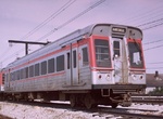 Image 21553 (204k, 1024x683) Collection of: Joe Testagrose Location: West Park | 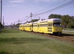 Image 21605 (262k, 1024x682) Photo by: Doug Grotjahn Collection of: Joe Testagrose Location: S. Woodland (Blue) |  Image 21636 (269k, 1024x687) Photo by: Steve Zabel Collection of: Joe Testagrose Location: Drexmore (Blue) |  Image 27859 (58k, 740x498) Photo by: Peter Ehrlich Location: North Coast |  Image 98844 (303k, 854x808) Photo by: Brian J. Cudahy Location: Tower City/Public Square |
Photos By Location
Red Line
Photo locations: Brookpark, Brookpark Yard, West 150th St/Puritas, West Park, West Park Yard, Triskett, West 117th St/Madison, West 98th St/Detroit (West Blvd.), West 65th St/Madison, West 30th Street Yard, West 25th St/Ohio City, Cuyahoga River Bridge, Tower City/Public Square, East 34th Street, East 55th Street, East 79th Street, East 105th St.-Quincy, University Circle, East 120th St/Euclid, Superior, Windermere (Louis B. Stokes)
Blue/Green Lines
Photo locations: South Harbor, North Coast, West 3rd, Flats East Bank, Settlers Landing, Tower City, East 34th, East 55th, East 79th, Woodhill, East 116th, Shaker Square, Coventry (Green), Southington (Green), South Park (Green), Lee (Green), Attleboro (Green), Eaton (Green), Courtland (Green), Warrensville (Green), Belvoir (Green), West Green (Green), Green (Green), Drexmore (Blue), S. Woodland (Blue), Southington (Blue), Onaway (Blue), Ashby (Blue), Lee (Blue), Avalon (Blue), Kenmore (Blue), Lynnfield (Blue), Farnsleigh (Blue), Warrensville (Blue), Kingsbury Run Yard, (Misc/Unknown)
Links
Official Site - Greater Cleveland Regional Transit Authority. The official site of the Cleveland RTA, including schedules, fares, and more.
Page Credits
By David Vartanoff. Route Map by Michael Calcagno.