St. Louis, Missouri
![]()
Two-car train passing what was then known as Kiel Center, approaching Union Station outbound. Photo by Peter Ehrlich, October 1994.
Overview
The first portion of the St. Louis Metrolink system opened on July 31, 1993, built and operated by the Bi-State Development Agency. The first line was 17 miles long, with 19 stations, (13 at street level, two in subways and three elevated), served by a fleet of 31 high floor LRV-style cars similar to those in Los Angeles. About 14 miles of the original alignment was built on existing rail right-of-way. The East Riverfront station in Illinois and Lambert Main Terminal station at Lambert-St. Louis International Airport opened in 1994. The Lambert East Terminal station opened in 1998. The initial phase operated from the Airport, through the University of Missouri-St. Louis campus, under Union Station, through a tunnel under downtown St. Louis, and across the rail deck of the Eads Bridge to downtown East St. Louis, Illinois.
There are two subway stations, 8th & Pine and Convention Center. A portion of the downtown subway is a former mainline railroad tunnel with a beautiful masonry arched roof, previously abandoned in the 1970’s. The tunnel underneath Union Station is the former baggage handling tunnel for that facility. Busch Stadium station is outside the west mouth of the tunnel. Laclede's Landing station is at the east mouth, inside the masonry of the anchor of the Eads Bridge, offering a nice view of the Gateway Arch, framed by Roman-style masonry arches. There are three elevated stations: East Riverfront (on the other end of the Eads Bridge) and the two airport stations. The most interesting elevated part of the ride is between the airport and North Hanley, where the track soars very high above the ground amongst the freeway overpasses. Trains on this section are visible from the air when flying into Lambert Airport.
A new 17-mile extension opened the weekend of May 5th, 2001, extending the line eastward into Illinois with 8 additional stations, terminating at Southwestern Illinois College. Large park-and-ride lots were constructed at all but one of the 8 new stations. This line was extended in 2003 one station further east, to Shiloh-Scott Station at Scott Air Force Base. A further extension to the Mid-America Airport was planned but has not been built.
While the original line runs through some pretty gritty urban areas, the new extension (once past East St. Louis) becomes increasingly rural, with some segments of the line passing through corn fields. At times, it feels like riding an interurban. Terminal-to-terminal travel time is about 1:25. Rush hour headway on the system is 7-8 minutes, off peak 10-15 minutes, and late nights (11:15-midnight), 30 minutes.
In 2006, a new line to Shrewsbury opened at the west end of the system. This line joins with the original Lambert line just west of Forest Park Station, following Forest Park Parkway west past Washington University. This section of the line is partially cut-and-cover subway due to residential opposition to surface operation. The original route proposal included some street trackage in Clayton, a wealthy suburb that’s also the St. Louis County Seat and the location of the courthouse, administrative buildings and many large office buildings. This plan was canceled, however, in favor of median running down Forest Park Parkway. Just west of Clayton, at I-170, the line turns south and follows a former freight railroad belt line south through Richmond Heights and Maplewood, terminating at Shrewsbury just south of I-44.
The primary maintenance facility and layup tracks are west of downtown St. Louis. A secondary manintenance facility without layup tracks was built about halfway down the new extension.
Neat things along the way: Delmar station is near an old railroad station. The building looks like a WPA project, too bad it isn't used as part of the MetroLink station. The neighborhood has a lot of neat restaurants, too.
Central West End. This is a pretty neighborhood. It's a university area, a little on the trendy side, the but architecture is pretty. Walk north and you'll get to Euclid Avenue, where there's a really cool used record store called Euclid Records, complete with clerks full of attitude straight out of the movie High Fidelity.
Busch Stadium: Get off here for the International Bowling Museum. If you like the movie The Big Lebowski this place will give you flashbacks.
5th & Missouri: In East St. Louis, catch the 555 bus at 37 minutes past every hour to visit the ruins of another city: Cahokia Mounds. It was the largest pre-Columbian city in what is now the United States, with a peak population of about 20,000 some time in the 1200s A.D. It was very advanced judging from the artifacts. There is a celestial calender there called Woodhenge, and you can see the Gateway Arch from the top of Monk's Mound, the highest of the ancient city's earthworks.
A one-way ticket comes pre-timestamped from the vending machine. Time is good for two hours, only in the direction you boarded. How do the spotters know? Since we only have one line at present, the fare spotters know what station you got embarked on and where you are when they check your ticket. Heading in the wrong direction of your validation? Tough luck - you get fined and ejected. Round-trip tickets must be validated by the passenger at a validation machine on the platform. Failure to validate your ticket is akin to riding with no ticket; i.e., if caught, a fine and ejection. The ticket expires 24 hours after purchase. Day passes require no validation and are good for unlimited rides. They are time sensitive and expire after 24 hours. Day passes are more expensive than a round trip ticket, so no one buys them unless they plan multiple rides in a 24-hour period. MetroLink also offers 10-day and monthly passes.
In 2008, system operation was divided into two lines, Red and Blue. Red line operation is from Lambert to Shiloh-Scott and Blue line operation is from Shrewsbury to Fairview Heights. Stations between Forest Park and Fairview Heights are served by both lines.
Also, there's a free lunchtime shuttle downtown. Between 11:30 and 1:30, no charge for trips between Union Station and Laclede's Landing.
Route Map
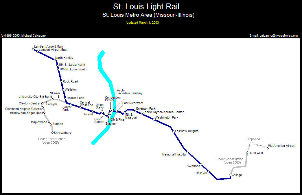
Photo Gallery
| Five Random Images | ||||
 Image 13268 (194k, 520x289) Photo by: Mark Michalovic Location: Convention Center |  Image 13292 (66k, 768x512) Photo by: Mike Farrell Location: Jackie Joyner-Kersee Shops/Yard |  Image 46610 (123k, 720x463) Photo by: Peter Ehrlich Location: Southwestern Illinois College |  Image 46620 (175k, 473x720) Photo by: Peter Ehrlich Location: Busch Stadium |  Image 69776 (210k, 1044x788) Photo by: Robert Franken Location: East Riverfront |
Photos By Location
Photo locations: Lambert Main Terminal, Lambert East Terminal, North Hanley, UM-St. Louis North, UM-St. Louis South, Rock Road, Wellston, Delmar Loop, Forest Park, Central West End, Grand, Near Scott Ave/S. 22nd St., Union Station, Near Kiel/Savvis Center, Civic Center, Busch Stadium, 8th & Pine, Convention Center, Arch--Laclede's Landing, Eads Bridge, East Riverfront, 5th & Missouri, Emerson Park, Jackie Joyner-Kersee Center, Washington Park, Bet. Washington Park and Fairview Hts., Fairview Heights, Memorial Hospital, Swansea, Belleville, Southwestern Illinois College, Scott Air Force Base, Mid America Airport, Skinker, University City-Big Bend, Forsyth, Clayton-Central, Richmond Heights-Galleria, Brentwood-Eager Road, Maplewood, Sunnen, Shrewsbury, Jackie Joyner-Kersee Shops/Yard, Grand Avenue Shops/Yard
Links
Official Site - St. Louis Regional Transit. The official site of the St. Louis Metrolink, including schedules, fares, and more.
Page Credits
By Dave Steckler and Mark Michalovic. Route Map by Michael Calcagno.