San Diego, California
Overview
The San Diego Trolley was the first new Light Rail system in California and has also been the most successful. The original line from Downtown San Diego to Tijuana cost only $86 million to construct and within a few years achieved near self sufficiency with fares covering over 90% of operating costs (the national average is only 30%-40%).
Most of the Orange Line as well as the Blue Line South of Downtown were originally railroad branch lines. This allowed the Trolley to buy the land very inexpensively. The old branch lines were upgraded, double tracked, electrified, and had stations put in. Freight service was also continued, now running mainly at night after Trolley service ends. The freight operation is run by the San Diego and Imperial Valley (SDIV) Railroad.
The quest to build an inexpensive and reliable system continued when it was time to select light rail vehicles. Planners wanted proven, off the shelf technology. Since the original system was financed without federal funds, the planners were able to buy German built vehicles from Siemens-Duewag. All the subsequent Trolley orders have come from the same manufacturer, with the newer ones being of a slightly different design.
A rider of today's San Diego Trolley will see an efficient, well run system. Trains and stations are kept clean and graffiti free. The inside of the trolley cars are fully upholstered and look almost new, despite some of the cars being 20 years old. Another interior touch are the little signs warning "High Performance Vehicle - Please hold tight at all times." The Blue Line features a 7 minute rush hour headway in addition to all night Saturday service form the border.
Maps
 Route Map |
 Track Map |
Station By Station
Blue Line
The Blue Line begins just across the border from Tijuana in San Ysidro. Although the station has two tracks, only one of them is used. When a train arrives at the San Ysidro/Tijuana station, doors are allowed to open on one side to let passengers off before the doors are allowed to open on the platform side where people are waiting to get on (all doors are passenger operated). The tracks run down the middle of San Ysidro Boulevard for a couple of blocks before swinging over to connect up with the San Diego & Imperial Valley Railroad tracks. The trolley runs up the SDIV right of way until reaching downtown, roughly paralleling Interstate 5. Stops are made at Beyer Boulevard, Iris Avenue, Palm Avenue, Palomar Street, H Street, Bayfront/E Street, 24th Street, 8th Street, Pacific Fleet, Harborside, and Barrio Logan.
The Blue Line cuts through the Trolley maintenance yard just before arriving at 12th & Imperial transfer station. The station has three tracks, four platforms, and is located under a large office building. As the name implies, this is also that station where the Orange Line joins the Blue Line for the trip though downtown.
As the tracks leave 12th & Imperial, they come out onto 12th Street. While some light rail systems have expensive raised trackways to keep autos off the tracks, double yellow lines do the job in San Diego. A stop is made at 12th & Market before reaching the City College stop at 12th & C Street. The City College stop is made on a sharp cure as the tracks turn onto C Street. While most of the buses would turn a block earlier to head down Broadway, the major street, the Trolley stays a block away on C Street and gets most of the street to itself. As the tracks head down C Street, stops are made at 5th Avenue and Civic Center.
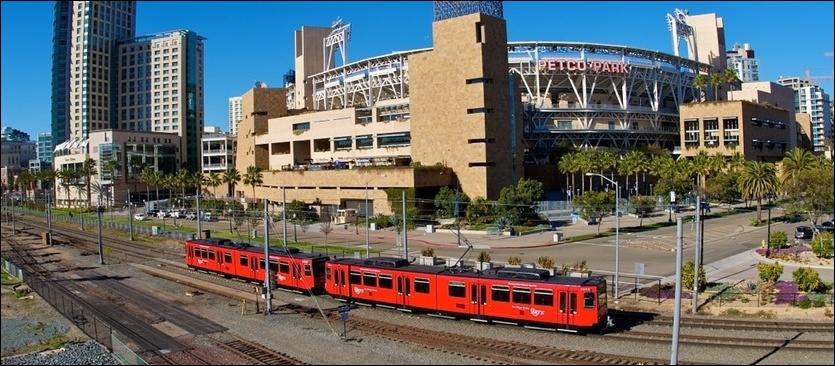
The tracks finally leave C Street as they curve and enter the America Plaza transfer station. The station is located between two buildings and has an overhead canopy. A block later, at the side of the Santa Fe Depot, the line splits. Orange Line trains turn left to head south on a shot stretch of track that gets back to 12th & Imperial. Blue Line trains turn right and head north in front of the Depot. The Santa Fe Depot trolley stop is located between the Depot and the mainline railroad tracks used by Amtrak, Coaster and an occasional BNSF freight. Coaster is a clone of Los Angles' Metrolink commuter train and goes between San Diego and Oceanside, where Metrolink service begins.
Leaving the Depot, the trolley parallels the BNSF tracks until reaching Old Town. The Trolley makes intermediate stops at County Center/Little Italy, Middletown, and Washington Street. Old Town Transit Center is a Coaster stop, as well as a turn around point for supplemental rush hour Blue Line Trolleys.
Upon leaving Old Town, the line curves away from the BNSF tracks as it crosses the San Diego River on a concrete trestle. For the rest of the line out the Mission Valley, the tracks stay near the river, crossing it a couple more times. A stop is made at Morena/Linda Vista before getting to the elevated station at Fashion Valley. The Fashion Valley station is next to a big mall, as well as big hotels across the river. Additional stops are made at Hazard Center and Mission Valley Center, another retail complex.
At the time of the first draft of this article, the next "station" was simply a construction site for a future station, surrounded by new building construction. Since then the station has been completed and named Fenton Parkway. The line next arrives at the elevated station next to Qualcomm Stadium. The station has three platforms and there is a third track on either side of the station for lay ups. After leaving Qualcomm Stadium, it is a short distance to the end of the line at Mission San Diego, which is a long walk from the actual Mission building. The line is due to be extended five more stops to meet with the Orange Line again at Grossmont Center.
Orange Line
The Orange Line begins at 12th & Imperial, at a single platform just around the corner from the main station. The Orange Line heads away from the main station and follows the BNSF tracks back to the Santa Fe Depot. Stops are made at Gaslamp Quarter, Convention Center and Seaport Village. Once reaching the Santa Fe Depot, the Orange Line joins the Blue Line to complete a big circle back the 12th & Imperial Station. From the main 12th and Imperial station, the Orange Line turns East to head down Commercial Street. (The section of the Orange Line shared with the Blue Line, is covered in the Blue Line section.)
Since Downtown streets limit trains to three cars, Orange Line trains sometimes have extra cars added after turning onto Commercial Street. Despite the name, Commercial Street is more industrial than anything, having a lot of scrap yards and warehouses. Stops are made at 25th & Commercial and at 32nd & Commercial, which rests at the end of the street trackage.
By now, the Trolley is again following an old railroad branch line. Stops are made at 47th Street, Euclid Avenue, and Encanto/62nd St. At Euclid, officially commissioned "graffiti" has done a good job a keeping more intrusive scrawls at bay and provides some interest to the adjacent station. The line passes through back yards and lightly forested areas as it continues to Massachusetts Avenue and Lemon Grove Depot, where the original railroad depot was moved back next to the tracks. More stops are made at Spring Street, La Mesa Boulevard, Grossmont Center and Amaya Drive.
By the time the line reaches El Cajon Transit Center, you get the feeling that you are not in San Diego any more. The tourists have run thin and the towns have gotten more relaxed. El Cajon is the end of the line for about half the Orange Line Trains. 15 minute service only continues to Santee during rush hour, and after 9pm all trains terminate in El Cajon. The rest of the time, every other train continues to Santee. Stops are made at Arnele Avenue and Weld Boulevard before reaching the single-track connection to Santee. The Santee Town Center station is in the middle of a brand new shopping plaza.
Roster
| Numbers | Designation | Manufacturer | Year |
|---|---|---|---|
| 1001-1014 | U2 | Siemens/Duewag | 1980 |
| 1015-1024 | U2 | Siemens/Duewag | 1982 |
| 1025-1030 | U2 | Siemens/Duewag | 1986 |
| 1031-1050 | U2 | Siemens/Duewag | 1990 |
| 1051-1071 | U2 | Siemens/Duewag | 1990 |
| 2001-2052 | SD100 | Siemens | 1995 |
| 3001-3011 | SD70 | Siemens | 2004 |
Photo Gallery
| Five Random Images | ||||
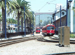 Image 15195 (228k, 824x558) Photo by: Eric Haas Location: Santa Fe Depot |  Image 37126 (175k, 720x472) Photo by: Peter Ehrlich Location: C Street | 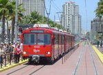 Image 39738 (253k, 1044x788) Photo by: Salaam Allah Location: Gaslamp Quarter | 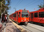 Image 68182 (186k, 1044x706) Photo by: Richard Panse Location: Rio Vista | 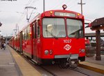 Image 76879 (101k, 922x692) Photo by: Phillip Lee Location: Old Town |
Photos By Location
Photo locations: San Ysidro/Tijuana, Beyer Boulevard, Iris Avenue, Palm Avenue, Palomar Street, H Street, Bayfront/E Street, 24th Street, 8th Street, Pacific Fleet, Harborside, Barrio Logan, 12th & Imperial, San Diego MTS Shops, Park (12th) & Market, City College, 5th & Market, 6th & Market, Civic Center, C Street, America Plaza, Santa Fe Depot, Grape Street Underpass, County Center/Little Italy, Viaduct at Laurel St., Middletown/Palm, Washington Street, Old Town, Morena/Linda Vista, Fashion Valley, Hazard Center, Mission Valley Center, Rio Vista, Fenton Parkway, Qualcomm Stadium, Mission San Diego, Grantville, SDSU Transit Center, Alvarado Medical Center, 70th Street, (Misc/Unknown), Santee Town Center, Gillespie Field/Weld Blvd., Arnele Avenue, El Cajon Transit Center, Amaya Drive, Grossmont Transit Center, La Mesa Blvd, Spring Street, Lemon Grove Depot, Massachusetts Avenue, Encanto/62nd Street, Euclid, 47th Street, 32nd & Commercial, 25th & Commercial, Commercial Street, Gaslamp Quarter, Convention Center, Seaport Village
Links
San Diego County, California Sprinter Description of the DMU "Sprinter" line in North San Diego County.
San Diego County, California Coaster Description of commuter rail service between San Diego and Oceanside (also some Amtrak service along this line).
Official Site - SD-Commute/Metropolitan Transit System of San Diego. The official site of the Metropolitan Transit System of San Diego, including schedules, fares, and more.
Page Credits
By Eric Haas. Route Map by Michael Calcagno. Track Map by Steve Hoskins.