Newark, New Jersey Light Rail/City Subway
![]()
Newark Light Rail LRV #102 at the Lackawanna Broad Street Station on the first day of service. Photo by Frank Pfuhler, July 17, 2006.
Overview
The Newark City Subway was, for the most part, constructed in the bed of the Morris Canal, which itself was built between Jersey City and Phillipsburg, NJ in the period 1825-1837. At its peak it was over 100 miles long and barges took five days to traverse its entire length. But, by the early 1900's, the railroads across New Jersey (specifically the Lackawanna and Jersey Central) signed the Morris Canal's death certificate and by 1920, the stagnant waters were a health hazard and the New Jersey state legislature pushed for the draining and filling of the canal bed.
In 1927, the Newark portion of the canal was authorized to become a right-of-way for streetcars, and construction began on this new subway on November 18, 1929. The downtown portion of the line was covered, creating a new street (Raymond Blvd.), while the outer portion was dredged out and overpasses were built at major cross streets and station locations. In 1934, rail was laid and the first test car traversed the tracks on October 3, 1934. Opening date for passenger service, between the original southern terminal at Warren Street and Heller Parkway, was May 16, 1935. The extension to Pennsylvania Station was completed and opened June 20, 1937. The northern extension from Heller Parkway to Franklin was completed on November 22, 1940.
In 1935, a number of Newark streetcar routes were diverted into the new subway. Street connections were built at various locations for streetcars to enter the subway. These connections were located at:
- Between Penn Station and Broad Street, connection to the Cedar Street subway, used by the 13-Broad St., 27-Mt. Prospect, and 43-Jersey City car lines; the Cedar Street subway was a short connection to the trolley terminal at the Public Service building; service could be run through the PSCT terminal to the City Subway;
- Between Washington and Warren stations for the 21-Orange via Market route;
- Just north of Norfolk St. station for the 23-Central Ave. route;
- At the Orange St. grade crossing for the 21-Orange via Orange St. route;
- At the Bloomfield Ave. station for the 29-Bloomfield route.
A new route, the 7-City Subway, was created and ran in the canal subway for its entire length. All of these connections are visible on the Track Map. Service on the streetcar routes was mostly short-lived as a program of bus-substitution began as early as July, 1937. During the early 1950's consideration was given to converting the Subway to dual-mode bus operation using electrical power while operating in the subway and diesel power while operating on the streets. This plan was discarded and arrangements made in 1952 to purchase 30 PCC cars from the Twin Cities Rapid Transit Co. to service the 7-City Subway. All of the other "surface" streetcar lines were eventually discontinued; the last of which was converted in March, 1952. This left only the 7-City Subway route still running in the Newark City Subway, using its private right-of-way for its entire run.
Maps

A map showing the streetcar connections in relationship to the City Subway is available here: SPUI's Newark Subway Map (PDF Format).
Current and Former City Subway Services
| Route | Entered subway at | Subway service began | Subway/streetcar service ended |
|---|---|---|---|
| 7-City Subway | Subway only | Initial segment, 5/16/1935; to Penn Sta., 6/20/1937 | n/a |
| 13-Broad St. | Cedar St. ramp | Continued thru Cedar St. subway from PSCT Terminal, 6/20/1937 | Replaced by trolley bus and cut back to PSCT Terminal, 7/18/1937; replaced by bus and still operated by New Jersey Transit as route #13-Broad St. between Newark and Irvington |
| 21-Orange via Orange St. | Orange St. | 5/26/1935, to Penn Sta. 6/20/1937 | 3/1/1951 (see below; current #21 bus uses Market St./W. Market St.) |
| 21-Orange via Market St. | Washington/Warren ramp | 5/26/1935, to Penn Sta. 6/20/1937 | Replaced by trolley bus 8/1/1937; replaced by bus and still operated by New Jersey Transit as route #21-Main Street between Newark and West Orange |
| 23-Central Ave. | Norfolk ramp | Diverted from PSCT Terminal to City Subway via Norfolk ramp; 6/20/1937 | 12/14/1947 |
| 27-Mt. Prospect | Cedar St. ramp | Continued thru Cedar St. subway from PSCT Terminal, 6/20/1937 | Replaced by trolley bus and cut back to PSCT Terminal, 12/29/1937; replaced by bus and still operated by New Jersey Transit as route #27-Mt. Prospect between Irvington and Clifton |
| 29-Bloomfield | Bloomfield ramp | 5/26/1935, to Penn Sta. 6/20/1937 | Bus-substituted 3/30/1952; still operated by New Jersey Transit as route #29-Bloomfield Ave. between Newark and West Caldwell/Parsippany via Bloomfield |
| 43-Jersey City | Cedar St. ramp | Began operating to PSCT Terminal 1/3/1927; presumably extended to City Subway 6/20/1937 | Bus-substituted 5/1/1938; still operated by New Jersey Transit as route #43-Jersey City between Newark and Jersey City |
Station By Station
City Subway
Newark Penn Station. Penn Station is an interesting Art Deco-era multi-modal facility which, in addition to the City Subway, supports New Jersey Transit commuter rail, Amtrak long distance trains, the PATH rapid-transit line to New York City, and local, regional and national bus services (NJ Transit, Greyhound, and other private operators).
The Newark Subway operates out of the lower level, the entrance to which is located in the extreme northeast corner of the station. Stairs descend to an intermediate level where there is a old wooden token booth and artwork in bronze of subway riders. This artwork is entitled The Commuters by Gregory Gurevich and was installed in 1994. Down one more flight from the mezzanine level, the subway station has five low platforms with a wooden crosswalk between them (kept closed). Only the two side platforms are used for regular passenger service. Lighting is fluorescent and walls are tan tile. Passengers exiting the station use an escalator which bypasses this intermediate level directly to the Penn Station street level concourse.
The extra tracks in the station and the stubs beyond formerly served as the main maintenance shops for the 1940s-era PCC vehicles of the City Subway. In-between the side platform areas is a maintenance shop and small yard for storage of the trolleys. At the south end of the station are two loops for turning the cars. The outer loop has an 82 foot turning radius and the inner loop a much tighter 62 foot turning radius.
Military Park. Formerly known as "Broad Street", this subway station with two low-level side platforms had its name changed on September 4, 2004, to avoid confusion with the Broad Street commuter rail station (at which will be the terminus of a new extension of the subway, see below). The new name was chosen to reflect the nearby park, and as a method of honoring the nation's veterans. The main tile color is tan and the tile band is blue with a top and bottom green border (similar to New York City IND subway stations). The platforms has been shortened from their original length by means of wrought iron railings and signs advising passengers not to go beyond this point. A mosaic name tablet in colors of dark blue and brown was found for Park Place, Broad Street East and Broad Street West.
Warren Street. Subway station with two low-level side platforms, which, as at Broad Street, have been shortened by means of iron fencing. The mosaic here continues the theme of scenes of the old Morris Canal. The tile walls feature a color band of two-tone gray and mosaic tablets indicating "To Street", "Lock Street", and "Warren Street". This is the last subway stop with the tunnel portal being at the north end, just beyond the end of the original platform.
Norfolk Street. The first of the stations in the open cut Morris Canal basin. The tile is white, having been placed on top of the original concrete walls. The top features three narrow tile bands of Orange, Mauve and Purple-- the NJT logo colors. Exits are up at both ends.
Orange Street. Grade-level station with one center island platform, directly south of the Orange Street grade crossing (for many years, the only such crossing on the City Subway-- there are now others on the northern extension). Formerly, this station had two side platforms, with the northbound one located north of Orange Street and the southbound one south of Orange Street (i.e. the trolley crossed the street before making the station stop). The changes can be seen in the photos. Access to the grade crossing is controlled by a standard street traffic light.
Park Avenue. Two low-level side platforms in an open cut. This station resembles Norfolk St. down to the tile on the walls. One exit on each platform is closed (the south exit on the northbound side, and the north exit on the southbound side).
Bloomfield Avenue. Two low-level side platforms in an open cut. Resembles Norfolk and Park. This station also has closed exits, with the closure pattern being the opposite of the pattern found at Park Avenue.
Davenport Avenue. Two low-level side platforms in an shallow open cut. Resembles Norfolk with the exception of wrought iron side walls allowing a view of Branch Brook Park.
Heller Parkway. Closed in 2001, this station had two low-level side platforms located in an shallow open cut. It featured two exits on the northbound side and a single exit on the southbound side, with almond-colored tile walls over the original concrete. The station was closed due to the proximity to the next station, which was made even closer by the reconstruction work at Franklin Avenue/Branch Brook Park station.
Branch Brook Park. Formerly known as "Franklin Avenue", this station was formerly the terminus of the City Subway route, with a single side platform at grade level on the southbound side, and a loop track at the north end. Northbound cars would traverse the loop and make a single station stop on the southbound side. This station was fully reconstructed in 2000-2001 for the subway line extension to Bloomfield, and it now has two tracks with three platforms (two sides and one island). The loop track has been removed. North of the station, the tracks cross Franklin Avenue at grade, and join the right of way of the Erie Railroad's Orange Branch (now operated by Norfolk Southern.) The freight trains operated on this branch share the tracks of the City Subway during off-peak hours.
Silver Lake. Grade level station with two side platforms located just "north" of the grade crossing at the intersections of Franklin Street (not Avenue-- Heller Parkway becomes Franklin Street as it passes into Belleville), Watchung Avenue, and Heckel Street.
Grove Street, in the city of Bloomfield, is the new terminus of the line, with a center island platform and two tracks. This station looks nearly identical to many of the center-island stations of the Hudson-Bergen Light Rail. Adjacent to the station is the new City Subway maintenance facility and yard.
Newark Light Rail to Broad Street
Planning began in 1998 to build a street-level light rail line connecting New Jersey Transit's Newark Penn Station with its Newark Broad Street station. Only one mile in length, the connecting line would not only serve Newark's two main rail stations but also its revitalizing Passaic River waterfront, including the New Jersey Performing Arts Center and the Newark Bears minor league baseball team's Riverfront Stadium. Construction on this new segment began in 2002 and was completed in 2006, at a cost of $207 million. Service began July 17, 2006.
The Broad Street branch of the "Newark Light Rail" begins, along with the Branch Brook Park "City Subway" service, at the lower level of Newark Penn Station (described above). Service on the two branches is not operated as a through service, therefore passengers can transfer between the branches here at Penn Station. Arriving passengers can remain on-board the light rail vehicles as they traverse the loop in Penn Station, for perhaps the first time since the City Subway opened. Trains to Broad Street depart Penn Station and diverge from the City Subway route at a grade-separated branch off the City Subway, which had only seen streetcar service between 1937 and 1938. This branch led to the former "Public Service Coordinated Transport" terminal at Park Place and Broad Street, under the terminal on the lower level, and then through to a portal along the alignment of Cedar Street between Halsey and Washington Streets. The new Broad Street branch merely reuses the grade-separated junction from the City Subway line, and not most of this "Cedar Street Subway", as it was known. Instead, a short new tunnel from about Park Place and E. Park Street, surfacing near the corner of Center Street and McCarter Highway, was constructed, allowing the new light rail line to run mostly alongside the wide McCarter Highway alignment.
The first new station is located in front of the New Jersey Performing Arts Center (NJPAC) alongside McCarter Highway north of Center Street. There are two side platforms. The roadway is separated via a small grass area and glass walls along the rear of the platform. This station is specially designed with a dual floating track bed to isolate train noise from the nearby performing arts center. The platforms are granite with chevron brick accents facing the direction of normal traffic. The track bed features a multi-colored granite inlay entitled Riding with Sarah [Vaughan] and Wayne [Shorter], by Athena Tacha. The edge of the platform behind the tactile ADA edging has the words to "Body and Soul" as sung by Sarah Vaughan. The sidewalk to the NJPAC features a "Walk of Fame" of famous performing artists, those who were born or live in New Jersey, such as Sarah Vaughan, Bruce Springsteen, Nathan Lane, Frankie Valli, Frank Sinatra, and Jerry Lewis.
North of the NJPAC station, near Fulton Street, the right of way swings west off of the McCarter Highway alignment, and then at Lombardy Street the tracks diverge, with the northbound track running along Atlantic Street in front of Riverfront Stadium to Division Street. A northbound-only stop is made at Atlantic Street, at Bridge Street, with one side platform on the east side. The station honors a nearby post office with a post card and postmark theme. The artwork is entitled Postcards from the Past, by Kate Dodd. The postcard scenes are entitled: "Newark, NJ The Renaissance City", "Regeneration for the next generation", "Passing through Port Newark", "Seduced by the suburbs", "Ensuring Insurance? A capital idea", "A house of knowledge for all", "A Town known for its fine breweries", "What goes in must come out", "Newark shoes keep the southerners on their toes", "Running to, through, and from New Jersey", "The Boyden Buzz is contagious", "Outsiders needing cider", "Fair trade", "Theocracy comes alive", and "Lenapes headed to Newark shellfish season".
Heading northbound from Atlantic and Bridge Street, the single northbound track passes directly in front of Riverfront Stadium, where another station is located, with one side platform on the east side. There is no artwork here at present. Departing the stadium station, the northbound track curves west (left) and meets up with the southbound track just across Broad Street. The tracks run along Lackawanna Avenue and cross University Avenue, and then enter Broad Street Station, on the street just in front of the south side of NJ Transit's (formerly Lackawanna) Broad Street Station. There's two tracks with an island platform. There is artwork here by Ik Joong Kahn, featuring a colorful array of 100 images, including children with magical powers, winter becoming spring, walls becoming windows, and strangers becoming friends. Behind the tactile edge are the words to Stephen Sondheim's "Send in the Clowns". Beyond the station the tracks merge into a single tail track and end at a bumper at Martin Luther King Blvd. A few blocks west down Orange Street the Branch Brook Park line of the City Subway/Newark Light Rail crosses north-south. Maybe one day the end of the Broad Street branch could be connected into a loop along Orange Street.
Departing southbound from Broad Street, there is an additional single-direction station along Broad Street, located at Bridge Street alongside Washington Park. The northbound station at Atlantic Street is just through the office buildings on the east side of Broad Street, but one would have to walk around the east side of Broad Street, but one would have to walk around the buildings on the street to get there. The station platforms feature wagon wheels and zig-zag art.
Weekday service is operated in peak periods with cars every two minutes. Daytimes the service is operated every six minutes, and late evenings every 30 minutes. Weekend base service is every 8 minutes Saturdays and every 15 minutes Sundays. The system is operated with a proof-of-payment system in which a rider validates a ticket at a stamping machine on each platform before boarding.
Some Technical Details
In 2000, the old trolley wire overhead was replaced with a the two-wire (or "simple") catenary system in a "Fixed Termination" (also known as "Variable Tensioned") configuration. In Fixed Termination (FT) simple catenary systems, the conductors are anchored at pre-determined tensions, to fixed structures at each end of the wire run. The selection of a fixed termination simple catenary system was justified for several reasons, not least because the high percentage of small radius curves makes the use of a constant tension system, where the cantilever frames supporting the wires must be allowed to "expand," relatively difficult. The deployment of the new system required the PCC cars in use at the time to be fitted with pantographs for a short while before their retirement.
Roster

Promotional announcement for the PCC cars. Collection of Frank Pfuhler.
| Number | Type | Builder | Year Built (Acquired) - Retired |
|---|---|---|---|
| 1-20 | PCC All Electric | St. Louis Car | 1946 (1952) Ret. 2001 |
| 21-25 | PCC All Electric | St. Louis Car | 1947 (1952) Ret. 2001 |
| 26-30 | PCC All Electric | St. Louis Car | 1949 (1952) Ret. 2001 |
| 101-118 | LRV | Kinki-Sharyo | 2000-2001 |
PCC cars purchased from Twin Cities Rapid Transit in 1952; 3 and 27 sold to Cleveland; 8, 18, 29 and 30 scrapped; remainder retired 8/26/2001. PCC car 27 at Shore Line Trolley Museum; several to San Francisco MUNI F-Market Line.
Prior to the modification of the line for LRV use, the City Subway had a few work cars that were converted from older streetcars as follows: 5223 (Line Car, built 1912); a Snow Plow (formerly used on the Trenton Fast Line a freight motor and plow, built 1921); and 5246 (Sweeper Car, purchased used in 1974, former Toronto Transit Commission's S39; former Third Avenue Railway; former Trenton Transit.)
Kinki-Sharyo LRV 117 former HBLR 2001, 118 former HBLR 2019.
Photo Gallery
| Five Random Images | ||||
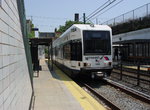 Image 27713 (455k, 1220x920) Photo by: Richard Panse Location: Norfolk Street | 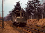 Image 74904 (171k, 1044x757) Photo by: Frank Pfuhler Location: Bloomfield Avenue |  Image 103349 (189k, 1044x701) Photo by: Richard Panse Location: Penn Station | 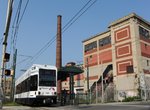 Image 103359 (182k, 1044x701) Photo by: Richard Panse Location: Orange Street | 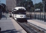 Image 127652 (230k, 1024x683) Photo by: Glenn L. Rowe Collection of: Joe Testagrose Location: Branch Brook Park |
Photos By Location
Photo locations: Penn Station, Military Park (formerly Broad Street), Washington Street, Warren Street, Norfolk Street, Orange Street, Park Avenue, Bloomfield Avenue, Davenport Avenue, Heller Parkway, Branch Brook Park, Franklin Avenue, Silver Lake, Grove Street, Shop/Yard, (Misc/Unknown), Portal, McCarter & Center, NJPAC/Center Street, McCarter & Rector, McCarter & Fulton, PRW Between Fulton & Lombardy, Lombardy Street, Atlantic Street (NB), Riverfront Stadium (NB), Broad & Division, PRW Between Broad & University, Broad Street Station, Broad & Orange (SB), Broad & Bridge (SB), Washington Park (SB), Broad & Lombardy (SB)
Links
Official Site - New Jersey Transit. The official site of New Jersey Transit, the operator of the Newark City Subway, including schedules, fares, and more.
The Newark Subway's WPA Murals. Interesting site about the WPA mural artwork (and other artwork) in the City Subway.
The Public Service Trolley Lines in New Jersey. By Edward Hamm, Jr. November, 1991. Transportation Trails, 9698 W. Judson Rd., Polo, IL 61064. A detailed description of the routes of the Public Service trolley system in Hudson, Essex, Bergen, Passaic, Morris counties and the interurban lines to Camden.
Page Credits
By David Pirmann and Peggy Darlington.