Miami, Florida
![]()
Miami Metrorail train at Coconut Grove. Photo by Paul Polischuk, August 2000.
TriRail Overview
Photo locations: Mangonia Park, West Palm Beach (Amtrak), Lake Worth, Boynton Beach, Delray Beach (Amtrak), Boca Raton, Deerfield Beach (Amtrak), Pompano Beach, Cypress Creek, New River, Fort Lauderdale (Amtrak), Fort Lauderdale/Hollywood Airport, Sheridan Street, Hollywood (Amtrak), Golden Glades, Opa-locka, Metrorail Transfer (Metrorail, Amtrak), Hialeah Market, Miami Airport
MetroMover Overview
Photo locations: School Board, Omni, 11th Street, Park West, Freedom Tower, College North, Arena/State Plaza, Government Center, Miami Avenue, Ft. Dallas Park (3rd St.), Knight Center, Bayfront, 1st Street, College/Bayside, Riverwalk, 5th Street, 8th Street, 10th Street/Promenade, Brickell, Financial District
MetroRail Overview
The Miami Metrorail operates on 22.4 miles of elevated track with 22 stations from Dadeland South to Palmetto. The service hours are 24 hours, with train headways every 6 minutes during rush hour, every 15 minutes during midday hours, and every 30 minutes after 8 PM on weekdays. Weekend service runs every 20 minutes. Free transfer is offered to the MetroMover by using a special exit at the Government Center and Brickell stations. Change/token machines are available at all stations since no station agents exist.
Trains are OPTO (One Person Train Operation) with cab operations on the left side of the train. During rush hour, six-car trains are operated by an ATO (Automatic Train Operation) system. During middays and evenings, four-car trains are used and operators have the option to drive the train manually or by ATO. Train movements are protected by an Automatic Train Protection system, since signaling is limited to crossover track locations. All train functions are performed by computers and are monitored at the command center at the Government Center Station. Sensors along the track that controls braking and acceleration monitor all train movement. The operator controls door functions and monitors train movement and speed.
Trains are stored at the Palmetto Yard just west of Okeechobee Station. The yard houses 136 Budd-built cars, part of the same order used to build the cars for the Baltimore Subway. Each car capacity is 166 passengers with a top speed of 58 mph. On the 22.4 miles of trackage, 7 crossovers are located at: Dadeland South (north of the station), Between University and Douglas Road *, Between Vizcaya and Brickell *, Culmer (west of the station), Brownsville (south of the station), Okeechobee (west of the station), Palmetto (west of the station). (* Indicates crossovers which contain a length of center track capable of storing a 6 car trainset.)
Photo locations: Palmetto, Okeechobee, Hialeah, Tri-Rail, Northside, Dr. Martin Luther King, Jr., Brownsville, Earlington Heights, Allapattah, Santa Clara, Civic Center, Culmer, Overtown/Arena, Government Center, Brickell, Vizcaya, Coconut Grove, Douglas Road, University, South Miami, Dadeland North, Dadeland South
Route Map

Track Map
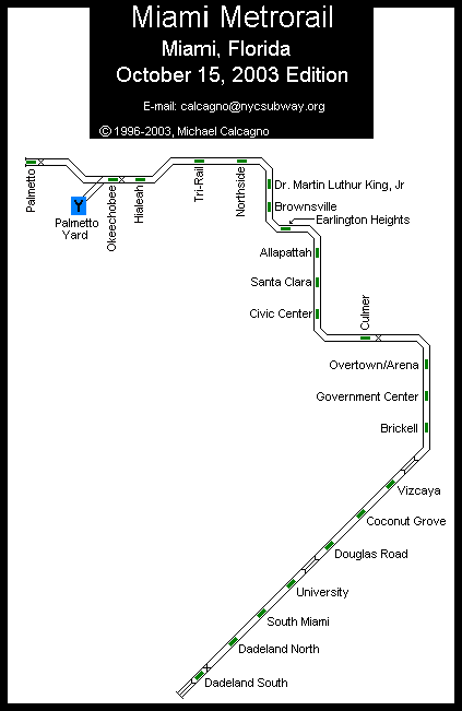
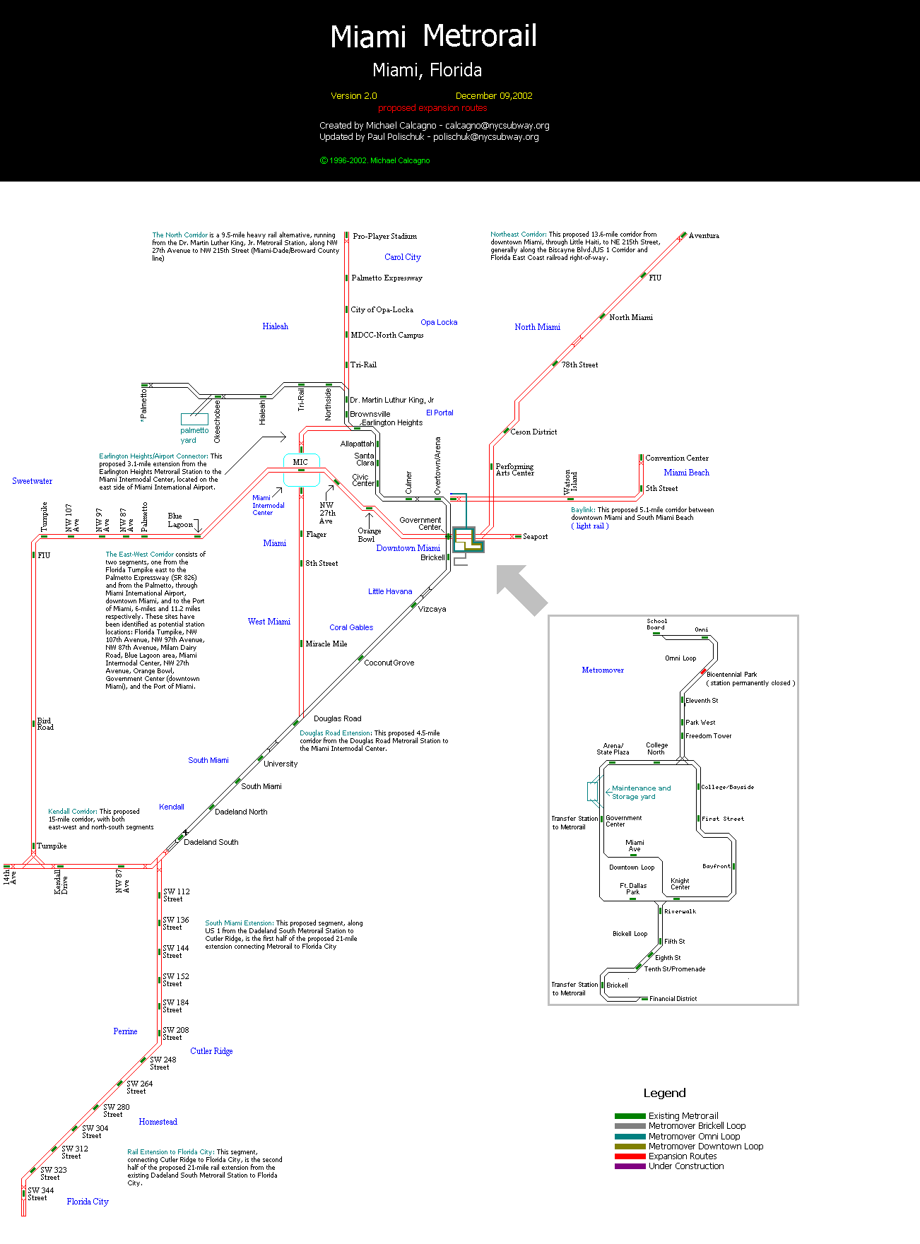
Photo Gallery
| Five Random Images | ||||
 Image 13370 (81k, 820x556) Photo by: Paul Polischuk Location: Coconut Grove |  Image 99053 (106k, 800x600) Photo by: Bob Vogel Location: Metrorail Transfer (Metrorail, Amtrak) |  Image 99058 (82k, 800x600) Photo by: Bob Vogel Location: Deerfield Beach (Amtrak) | 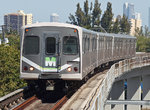 Image 108487 (372k, 1044x776) Photo by: Bob Pickering Location: Vizcaya |  Image 108491 (415k, 1044x799) Photo by: Bob Pickering Location: Hialeah |
Page Credits
By Bob Pickering and Paul Polischuk. Maps by David Pirmann, Michael Calcagno, and Paul Polischuk.