Denver, Colorado
Overview
Denver Light Rail - The Early Years
Denver, the capital of Colorado and a major distribution center for the western Plains States and Rocky Mountain states, developed rail transit shortly after its founding in the 1860s. Horse cars began service in 1871; cable cars arrived in 1888, and the first electric streetcar line started service in 1889.
Denver streetcars were unique in many ways. The lines were constructed to 3'-6" gauge (same as Los Angeles Railway and most San Francisco cable car lines); the name of the system was Denver Tramways, very unusual in the United States, and nearly all of the rolling stock was constructed by local builder Woeber Carriage Co. (See picture of car 53 on Larimer Street in the 1940s, from the Bill Volkmer/Dave's Railpix collections.) Later, some interurban lines were built to Boulder and Golden.
Denver Tramways began converting some streetcar lines to trolley coaches starting before World War II. The last streetcars rumbled through the streets on June 4, 1950. But just five years later, the trolley coaches were also eliminated.
Light Rail Comes To The Mile High City
Denver continued to expand, and the freeways, which promised more mobility, instead produced traffic jams and strangulation, as has been the case in other cities. The population was similar to the two Alberta cities, far to the north, which introduced light rail in the 1979s and 1980s, with great success. Would LRT work in Denver? For starters, civic leaders studied the Portland MAX light rail system, which began in 1986, and came away impressed, and convinced that light rail could work in the Mile High City.
Denver and regional leaders began by thinking small, developing a 5.3- mile Central Corridor line that cost $115 million, paid for entirely by local funds collected through a use tax on businesses levied by RTD, and revenue bonds--no federal money was used. Central Corridor, running from 30th Avenue and Downing in the Five Points district through downtown Denver via Welton, California/Stout Streets and W. Colfax, then along the BNSF Colorado Joint Line right-of-way south to I-25/Broadway, opened on October 7, 1994 as the first LRT system in the Plains and Mountain States. It was an immediate success, mirroring similar LRT installations across America. By 1999, over 16,000 riders were being carried each weekday.
First Expansion
Even with the opening and the subsequent of the Central Corridor, planning was already underway for the first extensions. Reaching the suburbs was deemed a critical step, and work began on developing the Southwest Line into Littleton. This was a relatively easy process, as it was most practical to continue along the BNSF/Union Pacific (ex- Rio Grande) Colorado Joint Line. Indeed, RTD pushed for this extension in 1994, and the FTA approve a Full Funding Grant Agreement in 1996. Total cost came to $177 million with Federal state and local funds used for this 8.7-mile extension, which opened for service on July 14, 2000. With nearly 30,000 riders using the Southwest Extension in 2007, this far eclipsed 2015 projections.
Central Platte Valley Line To Union Station
The next extension, Central Platte Valley, utilized a mix of public and private funding, totaling $47.8 million for this 1.8-mile line, which serves the Broncos' Invesco Field, Pepsi Center, the Six Flags Elitch Gardens amusement park, and Union Station. It opened for service on April 5, 2002.
T-Rex: Light Rail To The Southeast
Even as planning and construction of the line to Littleton was under way, the Denver Regional Council Of Governments, together with RTD and the Colorado Department of Transportation, began addressing the fast-growing Southeast Corridor, and its concomitant congestion along heavily-used I-25. The conclusion was that a major rebuilding of I-25, and I-225, coupled with a new LRT route, would be necessary.
This project came to be known as T-REX, an acronym for "Transportation Expansion Project". The price tag came to a whopping $1.67 billion for both freeway expansion and LRT construction. Federal funds comprised $525 million, the rest coming from voter- approved bond issues. The light rail portion, which included a second maintenance facility built along the Southwest Line at Elati (between Evans and Englewood Stations), totaled $879 million. Freeway reconstruction began in 2001; light rail construction commenced a year later. Like other LRT projects in Denver, T-REX was completed ahead of time and under budget. Service began way ahead of schedule, on November 17, 2006. 19 mies of new trackage was added to the system. The stations along T-REX were far more elaborate than those previously constructed.
FasTracks: The Next Big Project
The next big rail transit improvement program for the Denver Metro area is called FasTracks. This is a major 12-year program incorporating six new light rail and commuter rail lines and extensions and a bus rapid transit corridor to Boulder. It was approved by the voters in November 2005, with an 0.5-cent sales tax increase.
Construction of the West Corridor light rail line, the first of the FasTracks projects, began in May 2007, with estimated completion by the end of 2012. Union Station will be redeveloped to allow for commuter rail, including a line to Denver International Airport. Other commuter rail lines will extend to Longmont (via Boulder), Wheat Ridge and Lafayette. A major extension to the I-225 LRT line (from Nine Mile) and minor extensions of the Southwest and Southeast LRT routes are also included.
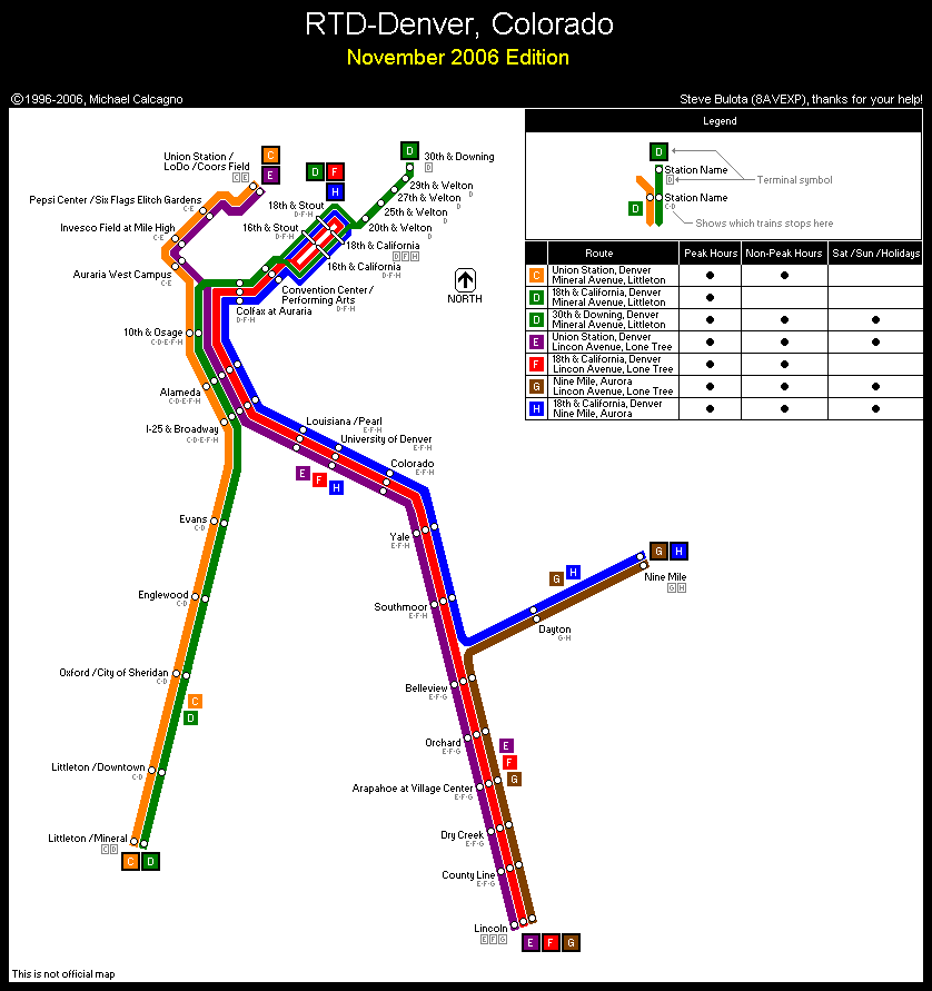
Station-By-Station
Five Points-Downtown-Colfax at Auraria
Denver's LRT system begins at 30th Avenue and Downing Station, where there is a bus transfer facility (including service to DIA) and a small Park-N-Ride garage. This is a double-track, stub-end terminal located in the Five Points District, a somewhat economically- depressed neighborhood. After leaving the terminal D Line trains turn onto Welton Street and operate on a single track, stopping at 29th & Welton, 27th & Welton and 25th & Welton Stations, all with simple shelters and sheltered handicapped-accessible ramps on each end, with boarding on both sides of the trackway. This is the only single-track stretch in the entire Denver LRT network. At Park Avenue and Welton, the line becomes double-track. 20th & Welton Station is an island station and marks the end to this extension from downtown, which opened in 1994. The line then crosses Broadway and turns right onto 19th Street. At California, the line becomes one way through downtown Denver, with inbound trains using California Street and outbound trains running on Stout Street. There is a left turn switch for trains on the F Line and H Line, plus peak hour trains on the D Line to loop through downtown.
Each street has two nearside stations, matching those on the D Line, at 18th Street and 16th Street. 16th Street is the transfer to the free Denver Mall Shuttle, which uses low-floor hybrid electric buses connecting between Civic Center Station and Market Street Stations as well as Union Station. Other local and limited-stop bus lines connect on 17th Street and 15th Streets. Interestingly, the LRVs on California and Stout face opposing auto traffic, but the LRVs use exclusive lanes.
There used to be stations at 14th Street, but these were replaced by the Convention Center/Performing Arts Station in December 2004. The new stop, with side platforms, is underneath the expanded Denver Convention Center.
Leaving the DCC, the line crosses split Speer Blvd. via a short bridge and then parallels West Colfax Avenue, stopping at Colfax At Auraria Station, a major stop serving the Auraria Campus of the University of Colorado-Denver. This is a side-platform station.
10th & Osage to I-25/Broadway
Following Colfax at Auraria, the line turns left and ducks under West Colfax Avenue. Double track switches lead to the Central Platte Valley Line, but these appear to have little usage. Past the underpass, trains from Central Platte Valley (C/E Lines) join up and parallel the Colorado Joint Line, which at one time was the province of the Burlington's Fort Worth & Denver and Rio Grande, but now is administered by BNSF and Union Pacific Railroad. The next station is 10th & Osage Station, an island platform station with an additional side platform for inbound trains, which lies opposite the old Rio Grande Yard and main shops, marked by long lines of retired UP locomotives and the Rio Grande Ski Train coaches. There are some grade crossings encountered after leaving Colfax at Auraria Station, but otherwise, the route is entirely grade-separated.
Following 10th & Osage, the Osage Maintenance Facility, the original one for LRT service, is passed. Next station is Alameda Station, which mirrors 10th & Osage in layout. After a short distance, we reach I-25/Broadway Station, with was the south terminal of the original Denver LRT installation. This is a three-track station, with two southbound tracks and one northbound track. Trains to Littleton-Mineral stop on the outside southbound track, while trains to Lincoln or Nine Mile stop on the center track. There is a shelter along the northbound track, next to the bus lanes. All northbound and Southeast-bound trains load on both sides. Until recently, the body of Denver Tramways Woeber Carriage-built trolley 117 (identical to car 53 shown) was used as a waiting shelter, but this has now been removed, and may actually be under restoration somewhere in the Denver area.
Central Platte Valley Line
This line, which opened in April 2002, snakes along the South Platte River into Union Station and the LoDo area of downtown Denver. It is served by the C Line from Littleton-Mineral and the E Line from Lincoln. Between the junction and north of Invesco Field at Mile High Station, there are some grade crossings. Then the line is grade-separated until the approach to Union Station.
After leaving the "main line", a stop is made at Auraria West Station, two side platforms with glass-block shelters. Next, we reach Invesco Field At Mile High Station, adjacent to the Denver Broncos football stadium. There are multiple platforms in both directions. On the south side, marble footballs line the edge of the station. The shelters, however, are patterned after the simple ones found on the original route.
The route curves northward and passes Six Flags Elitch Gardens, an amusement park hard by the river. Another station stop is located at Pepsi Center-Elitch Gardens, where the Denver Nuggets basketball team plays. There is a long overpass at the north end of the station. There are three tracks here, but one is used to stage extra trains only. Next, the route continues, paralleling the railroad to the 16th Street Bridge, a pedestrian walkway with a spectacular white mast projecting outward like that of a clipper ship. The route curves onto 16th Street and then left to Union Station (aka "Union Station/LoDo/Coors Field/16th Street Mall". Inbound patrons must get off here, and the light rail train will terminate north of the station and change ends. There are center and side platforms here. It's a short walk to the 16th Street Mall buses and a long walk into Union Station itself.
Southwest Line
We board a C Line or D Line train from I-25/Broadway. Just south of the station, the Southeast Line branches off to the left, rising onto an elevated structure, and another pair of tracks from the Southwest Line joins up with Southeast. Still paralleling the railroad, we reach Evans Station. with an island platform and extra side platform for inbound boarding. After Evans, we pass the new Elati Light Rail Maintenance Facility, which was constructed as part of the T-REX project, and then reach Englewood Station. This is quite a spectacular station, with an island platform, an additional inbound side platform, and an arch bridge for passengers heading to or from the modern Englewood Civic Center complex. A bus transfer area lies beneath this bridge, and there is fancy artwork rising from the bus plaza. Next, there is a rather ordinary station at Oxford, with only a center platform. Following Oxford, the line crosses the railroad and then reaches Littleton-Downtown, which has a center platform and a side platform for southbound trains. This station is nicely landscaped, and features the old Littleton railroad depot. The last station on the line is Littleton-Mineral, which has two side platforms. There is a bus staging area west of the station and a pedestrian footbridge over the railroad, which runs in an open cut. There is a single track for reversing trains south of the station. This line is entirely grade-separated.
T-REX (Southeast Line)–Louisiana/Pearl to Southmoor
The stations on the T-REX routes toward Lincoln and Nine Mile are considerably more elaborate than those on the original line. Later extensions continued the simple design, with some artwork and other embellishments added. But because T-REX was a pricier project due also to freeway improvements, it was necessary to design fancier stations and right-of-way alignments. The T-REX line is entirely grade-separated.
Basically, the Southeast Line parallels, and lies to the west of, Interstate 25, and arch bridge pathways are required to cross the tumultuous freeway traffic to reach the buses and parking garages. On the Nine Mile branch, the tracks lie in the freeway median of I-225. The trackway combines elevated, open cut and surface alignments throughout.
We take an E Line, F Line or H Line train out of I-25/Broadway Station. The line swoops over Broadway on elevated, then descends to an open cut. The first station reached is Louisiana/Pearl, a subterranean island-platform station that's rather ordinary, but the plaza above has spectacular artwork surrounding the station entrance, easily the most spectacular on the system. Next comes University of Denver Station, a surface site with a center platform and an additional side platform for outbound trains. Afterward, the line continues in an open cut to Colorado Station, with two side platforms. Next comes Yale Station, very open and laid out like University of Denver. Southmoor is the last station before the Nine Mile Branch splits off. This is a simple island-platform affair, with bas-relief artwork on the west wall.
T-REX (Southeast Line)–Belleview to Lincoln
South of Southmoor, there is a complex junction, with H Line trains turning left and flying over I-25 toward Nine Mile, followed by another set of tracks for G Line shuttle trains coming from Nine Mile heading for Lincoln. Just south of the junction is Belleview Station, similar to Yale and University of Denver in arrangement.
Starting with Orchard Station, a long arch bridge crosses the I-25 freeway for riders heading to and from the buses and parking garages. Next, we come to Arapahoe At Village Center Station in Greenwood Village, a major transfer point. The line crosses Arapahoe Road on an elevated and descends to Dry Creek Station. At County Line Station, there is a double-arch bridge as I-25 and I-225 split. All four of these stations are island-platform only. Finally, we reach Lincoln Station, which also has an outbound side platform. A 2-track tail for turning back lies south of Lincoln.
T-REX (Southeast Line)–Nine Mile Branch
The branch to Nine Mile is served by the H Line to downtown at all times, and the one-car, rush-hour-only G Line from Lincoln. Patronage on the latter is heavy on morning southbound runs and evening runs to Nine Mile. The route is entirely in the I-225 median. There are only two stations; Dayton, similar in layout to those between Orchard and Dry Creek, but with an arch over the southbound freeway that is painted white; and Nine Mile. As at Lincoln, there is a 2-track reversing stub. As part of FasTracks, the line may be extended northward by 2015.
Riding Denver Light Rail
Denver's system is divided into four zones. The fare (as of 2008) is $1.75 for a 2-zone ride; $3.00 for a 3-zone ride, and $4.00 for all four zones. Fares are Proof-Of-Payment; tickets are available from ticket vending machines, and are good for about 1 1/2 hours. Unlike Sacramento, San Diego and some other systems, Day Passes ($8.25 for a 3-zone pass) are NOT available from TVMs, and one has to go to either Market Street Station or Civic Center Station to buy them. Then one validated the Day Pass on the LRT platform.
Trains run every 15 minutes during the day, with service on the C and E to Union Station half-hourly (every 15 minutes north of I-25/ Broadway). Extra rush-hour service is provided on the D Line between Littleton-Mineral and 18th Street in downtown during rush hours. Service on the G Line is half-hourly, rush hours only. On weekends and holidays, only lines D, E and H operate, every 15 minutes.
The fleet consists of 49 Siemens SD-100 cars acquired in four groups between 1994 and 2000, numbered 101-149, and several batches of SD-160 LRVs, numbered 201 through 352. Normally, the two fleets are kept separate, but can trainline with each other, and mixed consists have been spotted occasionally. Most consists are two or three cars. Bicycles are welcome on Denver light rail.
Denver's light rail trains are clean and quiet, and there is no graffiti or other urban problems to be found.
Like most other cities that have introduced LRT, Denver has continued to shatter ridership records, and RTD's own estimates. In 2007, there were over 61,000 daily riders. With fuel prices in 2008 going through the roof, new records are most certainly being set.
So, for a truly Mile-High experience, Denver is recommended for the conoisseur of rail transport.
Platte River Trolley
The Platte River Trolley, run by the Denver Rail Heritage Society, began operations in 1989 with a "Naraganseett" 15-bench open streetcar, similar to those operated by New England trolley systems. Car 1977 was built by Gomaco of Ida Grove, Iowa, and is powered by an onboard diesel engine.
The trolley operates Fridays, Saturdays and Sundays from April through Halloween (and Mondays, too, between Memorial Day and Labor Day) and affords a spectacular view of Denver from the west bank of the South Platte River. The trolley also operates whenever the Denver Broncos play at Invesco Field. The trolley leaves Confluence Park half-hourly between noon and 4:00pm. Fare is $3.00.
The line begins at the old Power House (now a REI store) at 15th and Water Streets, a short walk across the 16th Street Pedestrian Bridge from Union Station/LoDo and light rail. The streetcar makes stops at the Denver Aquarium, the Children's Museum and Invesco Field.
There are plans for extending the line further southward to the Old Colfax area and across the 15th Street Bridge to Union Statiion, depending on funding. Alto, Denver & Intermountain Railway interurban car 25, which last ran in 1940, is undergoing restoration.
Maps
Route Map
Track Map

Photos
Photo Search
Photo Gallery
| Five Random Images | ||||
 Image 63931 (135k, 1044x652) Photo by: Daniel G. Jennings Location: I-25--Broadway (D/E/H) |  Image 68947 (197k, 864x547) Photo by: Peter Ehrlich Location: 15th & Stout (D/H/L) | 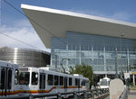 Image 91128 (166k, 864x574) Photo by: Peter Ehrlich Location: Stout & Speer (D/H) | 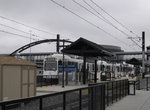 Image 91173 (153k, 864x574) Photo by: Peter Ehrlich Location: Dry Creek (E/R) |  Image 161224 (467k, 1220x820) Photo by: David Pirmann Location: 14th & Stout (D/H/L) |
Photos By Location
Photo locations: 30th & Downing (L), 29th & Welton (L), 28th & Welton (L), 27th & Welton (L), 25th & Welton (L), 24th & Welton (L), Park & Welton (L), 20th & Welton (L), 19th & California (D/H/L), 18th & California (D/H/L), 19th & Stout (D/H/L), 18th & Stout (D/H/L), 17th & California (D/H/L), 17th & Stout (D/H/L), 16th & California (D/H/L), 16th & Stout (D/H/L), 15th & California (D/H/L), 15th & Stout (D/H/L), 14th & Stout (D/H/L), Theatre District--Convention Center (D/H), Stout & Speer (D/H), Colfax at Auraria (D/H), Union Station (W/E), Ball Arena--Elitch Gardens (W/E), Invesco Field at Mile High (W/E), Auraria West (W/E), 10th--Osage (D/E/H), Mariposa Yard, Alameda (D/E/H), I-25--Broadway (D/E/H), Evans (D), Elati Yard, Englewood (D), Oxford--City of Sheridan (D), Littleton--Downtown (D), Littleton--Mineral (D), Louisiana--Pearl (E/H), University of Denver (E/H), Colorado (E/H), Yale (E/H), Southmoor (E/H), Belleview (E/R), Orchard (E/R), Araphoe at Village Center (E/R), Dry Creek (E/R), County Line (E/R), Lincoln (E/R), Sky Ridge (E/R), Lone Tree City Center (E/R), RidgeGate Parkway (E/R), Dayton (H/R), Nine Mile (H/R)
Links
Platte Valley Trolley - Official Site
Platte Valley Trolley - Wikipedia
Page Credits
By Peter Ehrlich.