MBTA Mattapan-Ashmont Line
![]()
Restored PCC 3268 on the MBTA Mattapan-Ashmont line at Mattapan loop. Photo by Richard Panse, January 2008.
Overview
This short trolley operation, unique in the MBTA because it still uses PCC trolley cars, runs from Ashmont to Mattapan, the end of the line. This route, only a few miles long, has 6 stops along its way to Mattapan. It was built on a railroad right of way to help speed trolley cars into Boston from the Dorchester area. At only 2.2 miles the line is one of the shortest existing trolley lines, but it is surprisingly scenic considering its location on the border of a major city.
Route Map
Station By Station
Mattapan station is located east of the intersection of Blue Hill Av. with River St. and is three tracks wide with a loop on the west side. Outbound cars arrive on the northernmost track while inbound cars load and depart on the middle track. The southerly track is used for pulloffs which pass through the station eastbound and round a second loop to enter the ready track or pit track. A switch also allows cars on the southerly track to access the inbound main but this is seldom used. Cars from the ready and pit tracks enter the main line through a third loop which connects only to the middle track at the station. There is no provision for return to the yard.
Mattapan station itself is a false facade similar to the complete facilities at Fields Corner and Ashmont (and the former one at Andrew) facing west with a roof extending about 40 feet east. A longer canopy covers the space between the outbound track and the north busway which serves routes 24 Wakefield, 27 Ashmont via River St., 30 Cummins Hwy., 33 Dedham Line via River St., 245 Quincy and a privately operated mini-bus to Canton. The south busway passes west of the loop and south of the yard tracks, looping between the yard and pit to its loading area between the station and yard. It serves three routes, 28 Ruggles via Dudley, 29 Jackson Sq. via Seaver, and 31 Forest Hills via Morton, and has no canopy.
A small repair shelter is being constructed over the tracks at the pit to facilitate winter car work.
Leaving Mattapan the tracks curve slightly to the right and cross the Neponset River into Milton. The next station, Capen Street, is a grade crossing of a cul-de-sac with the inbound and outbound platforms staggered to allow the stop to be made before crossing the road. There is no crossing protection, and the stop is mandatory. A small shelter is provided on the inbound platform only.
Leaving Capen St. the line curves to the left and enters one of its longest straightaways, along the south bank of the Neponset River. About halfway down the tangent is Valley Road station which features two opposing platforms of similar length with a canopy over the inbound platform. A long stairway leads up to the intersection of Eliot St. and Valley Rd.
Leaving Valley Rd. the line continues straight for several hundred feet, and then curves to the right entering Central Avenue station. Central Av bridges the Neponset River and ends at River St. in Boston, where there is a shopping mall with Star Market, Osco Drug, a bank and several other stores. Numerous small businesses are nearby on both sides of the river. The line crosses Central Av. at grade, and again there is no protection, so a full stop is required before crossing in both directions. Both station platforms are west of the crossing, requiring outbound cars to stop twice. As usual there is a canopy over the inbound platform only. Connections can be made with the 240 bus to Ashmont or Randolph, the previously mentioned 27 bus, or the Brockton Area Transit (BAT) Route 12 to Brockton
Leaving Central Av. the line is relatively straight rising along the side of a hill before descending into Milton station. A former freight track right-of-way begins at the east side of Central Av. and parallels the trolley line for about a half mile. A siding crossing a bridge over the Neponset, which served the Baker Chocolate Factory, can be seen on the left.
The intersection of Adams and Eliot Sts. occupies a long bridge, recently rebuilt, over the tracks, and a stairway on the east side leads down to the inbound platform of Milton Station. Due to the bridge, grade, and the proximity of the stairway, inbound cars must make a full stop entering the station. The Baker plant, now mostly redeveloped, dominates the area on the Boston side of the river with its four story brick buildings. Just beyond lies Pierce Square, a thriving local business district. To the south is Milton Village, another cluster of small shops and proffessional offices. Passengers can exit at grade to this area or climb the stairs to Adams St.
Leaving Milton the tracks curve slightly to the left and pass the remains of a warehouse which was destroyed in a major fire in 1999, and cross a bridge over the Neponset which is flanked by abandoned railroad bridges on both sides. To the south can be seen a yacht club and its flotilla of pleasure craft, while the Baker plant still dominates the scene to the north. Once across the river into Boston the tracks pass under Medway St. and enter Butler Street station. Butler Station has a long island platform with two walkways across the tracks to the two ends of Butler St. which is divided in two by the rail line. Both walkways also serve as mini-platforms and sit on the old freight rights-of way. Butler Station originally had an overhead walkway with stairs down to the island platform, but this was removed in an early 1980s rebuilding. A modern looking gable roof, was grafted onto the old canopy leaving a strangely mismatched piece of architecture.
From Butler, the trolley tracks rise and cross an overpass through which once passed the northerly freight spur. They curve to the left and enter Cedar Grove Cemetery. This is the most scenic point on the line with the Neponset Marshes with the winding river to the south and the garden cemetery to the north. As the tracks descend from the overpass, they enter a cut which bisects the graveyard. A private bridge connects the two parts of the cemetery, followed by a short left hand curve, and another bridge taking the line under Adams St. to Cedar Grove station. The stop lies at the intersection of Fellsway and Milton Sts. and the inbound platform opens directly onto Fellsway St. A passage from the outbound platform leads to the end of another local street, and overlooks the Codman Yard of the Red Line.
Leaving Cedar Grove the line continues in a straight line to Ashmont passing the Codman Yard on the left and crossing Gallivan Blvd. on a bridge shared by the Rapid Transit yard tracks. The turnaround area for the Red Line occupies the left side from Gallivan to Ashmont Station, where the tracks rise and separate, being joined by the station busway at the top of the viaduct, where another full stop is required. The inbound car descends into the station, discharges its passengers, and makes the loop to the north, mingling with the buses before entering its own bay on the west side of the station, where it will load for its return to Mattapan.
Roster
The Mattapan-Ashmont Line first became an orphan in 1955 when the Mattapan to Egleston car line was bustituted. At that time a mix of Type 5s and All Electric (3197-3221) PCC cars were assigned, and the operators continued to be assigned from the Arborway, while the cars were assigned to Bennett St. in Cambridge, and hauled back and forth through the subway with a special adapter coupler. The last Type 5s were retired in 1958, and PCC cars became the only equipment. At the same time, Bennett St. became a trackless trolley facility, and the pit was constructed at Mattapan to allow running repairs there. The official car assignment became Arborway, and it remained so until 1985. Heavy repairs were conducted at the Eliot Shops for a while, but by the mid 1960s, even this practice had ended. The arrival of the higher numbered Dallas Cars (3330-3246), resulted in these cars being trucked to Mattapan. The All Electrics were refitted as MU cars and assigned physically to Arborway.
Over the next twenty years there were some car swaps between Arborway and Mattapan, always involving the same two fleets and usually ending up with the Dallas cars going back to the High Speed Line. By the early 1970s two Dallas cars had departed Mattapan (3339 wrecked and 3342 flooded) and 3197 and 3212 were assigned to replace them. Both cars were there to make the numbers work and neither was used frequently. They usually sat on the loading ramp, pole down, behind the snow plows.
The fleet started to shrink in the late 1970s, as the all electrics were scrapped and the Dallas cars began to wear out. 3332 was reassigned to Arborway to fill in there. A coat of red paint improved the cars appearance, but did nothing for the reliability. In 1978, Boeing LRVs took over the shuttles to Brigham Circle and Northeastern, freeing most of the low numbered Dallas cars and 3332 to go back to Mattapan.
Finally, in 1981, the line was shut down for a 6 month rebuilding, and the Dallas Cars were retired. When the line reopened, a dozen rebuilt wartime cars were assigned to Mattapan, with all of the remaining PCC cars now at Arborway. These cars remained there for about three years, after which they were swapped for picture window cars, in order to beef up the reliability of the very visible Arborway Line which needed trains, and isolate the cantankerous picture windows as singles at Mattapan.
The MBTA threw in the towel on the Arborway Line in December of 1985, and began concentrating the most recent rebuilds at Mattapan. Since the remaining part of the line to Brigham Circle or Heath St. was now being operated from Reservoir, the Mattapan operators were transferred there too. By February 1986, the Mattapan fleet was in its present state, though some cars were swapped after a wreck. Most of the spare PCCs were stored until the early 1990s. At that time the rebuilt cars were sold as complete units and the picture window cars were junked. Three cars remained at the Arborway Carhouse, 3228, another wreck victim, and 3241 and 3264 which looked like the rebuilds but weren't and so fell through the cracks of the scrapping program.
With the MBTA committed to keeping the PCC cars in the late 1990s, the present rebuild program began. The three cars at Arborway were inspected, and deemed to be too far gone to be worth the effort. They were heavily stripped, including the cutting off of some steel to repair body sections, and junked in 2000 when the Arborway Carhouse was torn down to make way for a bus garage. The 11 remaining cars are being rebuilt to better than new standards, and will probably end up lasting upwards of 75 years. Not bad for cheap wartime construction!
All unrebuilt cars are painted Green with White around the windows, Gray or Silver roof, and Black Trim. Interiors are Cream with stainless wainscoting and Black panels at the front.
Rebuilt cars are Traction Orange below the belt rail and Cream above with the belt rail itself Maroon. Trim is Black including the anticlimbers and couplers, roofs are Silver. Interiors are as above with Maroon replacing the Black.
The orange paint scheme is very close to the original in which the cars were delivered between March 1945 and May 1946. The remaining cars represent three separate orders from Pullman, and all were previously "rebuilt" in the early 1980s. Current work includes extensive underframe repairs, stainless steel stepwells, rewiring and complete mechanical overhaul. The orange paint is very visible at night and conveys a much warmer appearance than the green.
The short-term future is secure for this line, but the long term future is uncertain. There have been several ideas to upgrade this old line, and its PCC cars. Bringing in LRV's and other light rail equipment is not possible, as the bridges would not support the heavier cars. There has been a proposal to rip the tracks up, and pave it over, making it a busway. Other proposals include upgrading track to allow for the LRV's. The PCC cars still roll for now.
All-Time Roster
| Prior to 1955 | Cars were assigned to Mattapan on a rotating basis from Park St. Carhouse in Dorchester (up to 1948) or from Arborway (1948 onward). Type 4 cars were used from the time the line opened in 1928 and 1929 until 1948. Type 5 cars were used until 1955 when the first PCC cars were assigned. |
| 1955 | All Electrics 3197 to 3209 assigned. Type fives in rush hours. (13 cars total) |
| 1956 | All Electrics 3210 to 3213 assigned. Fewer type fives in rush hours. (17 + 3 Type 5) |
| 1958 | All Electrics 3214 to 3215 assigned. All service with PCCs. (19) |
| 1960 | Dallas Cars 3330 to 3346 assigned. 3197 to 3215 returned to Arborway. (17) |
| 1961 | Dallas Cars 3330 to 3331 returned to Arborway (15) |
| 1966 | All Electrics 3197 to 3213 assigned. All Dallas Cars except 3337 returned to Arborway. (17). Then, Dallas Cars 3334 to 3336 and 3338 to 3346 assigned. All all-electrics except 3197, 3198, 3201, 3204, 3208, 3209 and 3212 returned to Arborway (20). The Dallas cars were returned to the Green Line to allow more flexibility in short turns. This proved unsuccessful due to loading characteristics and they were returned to Mattapan. |
| 1967 | All Electrics 3198, 3201, 3204, 3208, 3209 and 3212 returned to Arborway (14) |
| 1968 | Dallas Cars 3330 to 3333 assigned. 3342* out of service. (17) |
| 1969 | Car 3197 out of service. (16) |
| 1970 | Cars 3338 out of service and 3339 retired due to wrecks. 3197 returned to service and 3212 assigned. (16) |
| 1971 | Car 3332* out of service (converted to double end line car). (15) |
| 1972 | Car 3338 returned to service. (16) |
| 1973 | Car 3197* retired. (15) |
| 1974 | Car 3212* retired. Last all electric assigned to Mattapan. (14) |
| 1975 | Cars 3333 and 3346 out of service due to fires. (12) Car 3333 was under repair when retired ca. 1978. |
| 1976 | Car 3343* out of service. Car 3346 returned to service (12) |
| 1977 | Cars 3335 and 3341 out of service due to wreck. 3335 retired. 3341 returned to service. (11) |
| 1978 | Cars 3322, 3325, 3327 and 3328 assigned. (15) |
| 1979 | Cars 3330 (wreck), 3331, 3336(wreck), 3340(wreck) and 3344 out of service. 3340 returned to service. Others retired. (11) |
| 1980 | Cars 3259 and 3266 assigned. First use of rebuilt wartimes at Mattapan. (13) |
| 1981 | Line shut down for track replacement. Cars 3259 and 3266 out of service. Cars 3322, 3325, 3327, 3328, 3334, 3337, 3338, 3340, 3341, 3345 and 3346 retired. |
| 1982 | Cars 3086, 3087, 3222, 3226, 3244, 3246, 3252, 3255, 3260, 3262, 3263 and 3266 assigned. (12) |
| 1985 | Cars 3086, 3087, 3222, 3226, 3244, 3246, 3252, 3255, 3260, 3262, 3263 and 3266 returned to Arborway. Cars 3300, 3303, 3304 to 3307, 3309, 3310, 3312 to 3316 assigned. (13) Cars 3307, 3309, 3310, 3312 and 3315 retired. Car 3232 assigned. (9) |
| 1986 | Cars 3086, 3222, 3230, 3234, 3237, 3238, 3254, 3262, 3263, 3265 and 3268 assigned. (12) |
| 1987 | Cars 3086 and 3237 retired due to wreck. Cars 3087 and 3260 assigned. (12) |
| 1993 | Cars 3222 and 3262 out of service due to wreck. Car 3222 retired. Car 3262 returned to service. (11) |
| 1998 | Car 3268 out of service for rebuild. Car 3265 out of service for rebuild. (9) |
| 1999 | Car 3265 in service. Car 3260 out of service for rebuild. (9) |
| 2000 | Car 3268 in service. Cars 3087 and 3263 out of service for rebuild. (8) Cars in service as of 10/18/00: 3230 3232 3234 3238 3254 3262 3265 3268. Type 3 plows 5136 and 5154 were assigned to Mattapan after 1955. 5154 was retired in 1974. 5136 was transferred to the Green Line in 1981. 5164 was assigned in 1982. |
| 2004 | 3087, 3263 back in service. Cars seen operating in May 2004: 3087 3234 3254 3260 3263 3265 3268 |
| Notes: * These cars were seldom used after 1970 and usually were stored dead on the loading ramp. Cars 3332, 3342 and 3343 were repaired and returned to service on the Green Line. | |
Photo Gallery
| Five Random Images | ||||
 Image 31398 (68k, 820x620) Photo by: Richard Panse | 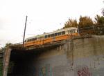 Image 35604 (153k, 1044x788) Photo by: Richard Panse Location: Cedar Grove |  Image 88168 (158k, 864x574) Photo by: Peter Ehrlich Location: Mattapan |  Image 114964 (201k, 1024x678) Photo by: Joe Testagrose Location: Mattapan |  Image 115056 (235k, 1024x708) Photo by: Joe Testagrose Location: Butler Street |
Photos By Location
Photo locations: Ashmont, Cedar Grove, Butler Street, Milton, Central Avenue, Valley Road, Capen Street, Mattapan
Page Credits
By Gerry O'Regan and Bob Pickering.