MBTA Green Line
![]()
MBTA Green line LRV on line C at Beacon & Tappan. Photo by Richard Panse, October 2004.
Overview
The Green Line of the MBTA is the oldest Boston rapid transit line, and portions of which date back to 1897, making it the oldest subway line in North America. Similar to subway-surface trolley lines in Philadelphia and San Francisco, the Green Line consists of a downtown tunnel and several radial routes exiting the tunnel at various locations. The branches are mostly remnants of former Boston streetcar lines, with the exception of the D branch - a former surface railroad line. The Green Line opened in phases from 1987 to 1959, with some cutbacks and rebuilding resulting in portions abandoned. An extension project bringing the Green Line past its previous northern terminal at Lechmere, opened in 2022.
Line by Line
Northern Extension and Elevated Portion
New stations at Medford/Tufts, Ball Square, Magoun Square, Gilman Square, East Somerville, and Union Square as well as a relocated Lechmere station, are opening in 2022 as part of a northward expansion of the Green Line.
Union Square, opening March 21, 2022, lies at the end of its own short branch, alongside tracks of the MBTA Commuter Rail Fitchburg Line. The Green Line consists of two dedicated tracks on the north side of the commuter tracks. The station has two stub end tracks alongside an island platform. Exit is to the north/west end at Prospect Street. Departing Union Square there are a set of crossover switches and then a grade-seperated flying junction joins up with the Medford branch. The junction lies at the edge of MBTA commuter rail yards, and the north/westbound flyover track has a small provision for some kind of future connection to these yards.
The former surface station at Lechmere, just northwest of downtown Boston in eastern Cambridge, was the end of the line until 2022. This station was a surface stop, consisting of a loop track that circles a small storage yard. Station platforms are on either side of the loop, on the outside perimeter. The new Lechmere station is on the north side of Lechmere Square, and consists of two tracks on elevated structure along a slightly curved island platform.
From Lechmere, the Green Line climbs an incline over a street and up to the Lechmere Viaduct dated 1912. The viaduct, a long arched structure, takes the line east/southward, across the Charles River Dam, and past the Museum of Science. Science Park is at the end of the viaduct as the Green Line enters elevated trackage. The Science Park Station is two platforms on either side of the two tracks. The (new) tunnel portal is just east, alongside Martha Road at Nashua Street.
Prior to 2004, the elevated section takes the line over the city streets in the area of North Station, and was the last "EL" operated by the MBTA. The line takes a sharp turn east, to the former elevated North Station stop. This station was one of the more unique on the Green Line as it featured both an elevated station, and also a surface level platform on the street. Trains that would terminate at North Station would use the surface station, trains continuing on toward Lechmere use the upper level. The surface stop was closed in 1997 as part of the Green Line relocation project. Continuing, the Green Line turned sharply back to the south and descends an incline into the subway at Haymarket Portal. Passengers could transfer to the Orange Line or commuter rail from this station, and it was also the site of the old Boston Garden, now demolished. After 2004 the old Haymarket portals were removed.
Photo locations: Medford/Tufts, Ball Square, Magoun Square, Gilman Square, East Somerville, Union Square, Lechmere (2022 Station), Lechmere, Science Park
Green Line Subway
The entire area around North Station has seen some major changes recently in conjunction with Central Artery "Big Dig" highway project and the Green Line relocation. The relocation project moved the Green Line into a subway. The new Green Line subway will run beneath the former Green Line North Station, exiting out of a new portal to take the line to the Lechmere Viaduct. The new North Station stop can be thought of as a "superstation", featuring shared inbound platforms for Green Line and the MBTA Orange Line.
Heading south, the original platforms of Haymarket station are visible along the outer sides. The current Haymarket station was relocated slightly and opened on May 10, 1971. This station has a low-level side platform on either side of the tracks. Passengers can also transfer here to the Orange Line.
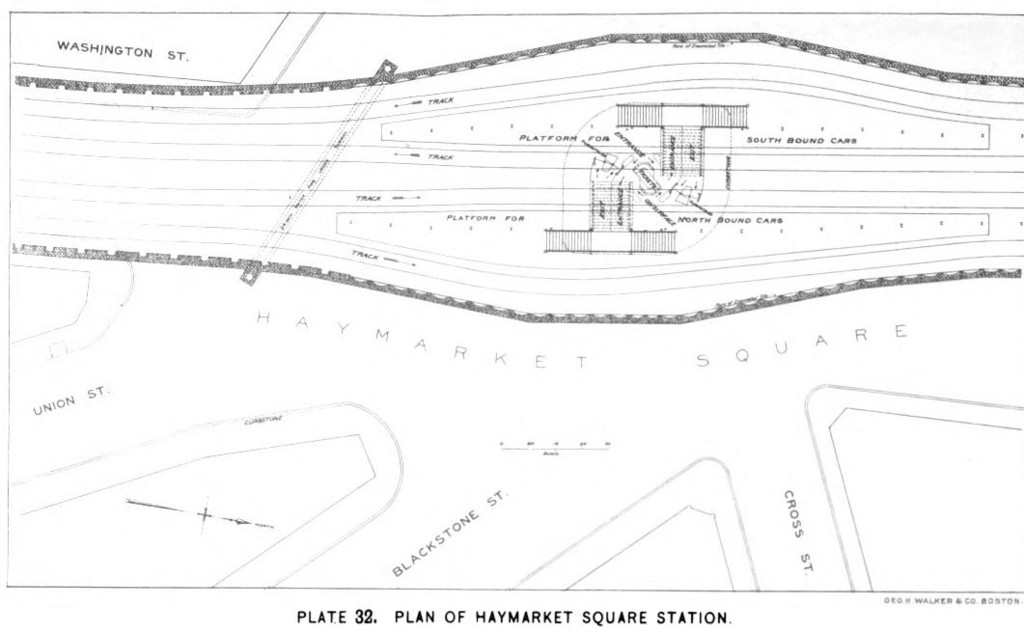 Plan of Haymarket Square Station. Boston Transit Commission report, 1898. |
 Haymarket Square Station, South Bound Platform (looking North). Boston Transit Commission report, 1898. |
 Stairway Building, Haymarket Square Station (looking North). Boston Transit Commission report, 1898. |
The next stop is Government Center. The original station at this location was known as Scollay Square and was rebuilt as part of the Government Center redevelopment. The current station reopened on October 28, 1963. The station is sort of shaped like a triangle, with the active tracks running along two sides, and a loop around the third. The loop track in the station can be used to turn trains back to Lechmere, but this is rarely done and the platform is disused. (Another loop track, northeast of the station, can be used to turn trains coming from Park Street.) The unusual shape of the station has to do with the City Hall building above, which required the northbound track to be relocated. A station in between Government Center and Haymarket, known as Adams Square, was closed and completely demolished during the Government Center construction. Green Line passengers can transfer here to the MBTA Blue Line operating on a lower level.
 Plan of Scollay Square Station. Boston Transit Commission report, 1898. |
 Cross Sections, Scollay Square Station. Boston Transit Commission report, 1898. |
 Building over Stairway, Centre of Scollay Square (looking Northeasterly). Boston Transit Commission report, 1898. |
 Building over Exit Stairway, Northerly end of Scollay Square (looking Southwesterly). Boston Transit Commission report, 1898. |
 Southerly end of Platform for North Bound Cars, Scollay Square Station (looking North). Boston Transit Commission report, 1898. |
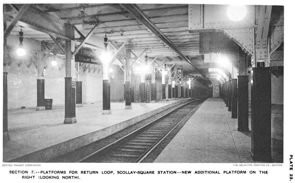 Platforms for Return Loop, Scollay Square Station - New Additional Platform on the Right (Looking North). Boston Transit Commission report, 1898. |
 Platforms for Return Loop, Scollay Square Station - New Additional Platform on the Left (Looking South). Boston Transit Commission report, 1898. |
 Escalator and Exit Stairway Coverings in Scollay Square, Looking Southerly Towards Entrance to Tremont Street Subway. Boston Transit Commission report, 1916. |
 Plan of Adams Square Station. Boston Transit Commission report, 1898. |
 Stairway Building, Adams Square Station (looking Northeast). Boston Transit Commission report, 1898. |
 North Bound Platform, Adams Square Station (looking South). Boston Transit Commission report, 1898. |
The next station is the famous Park Street. This station has seen trolleys for over 100 years, as it is part of the original 1897 subway. Here the Green Line diverges into four tracks, two each direction. One track is actually built into the platform allowing people to cross the track. Street cars rumble through, clanging bells, and stopping at designated locations along the platforms. Each location represents a different destination on the Green Line. Passengers must be at the right place to board the right train. Destinations are also well displayed on the roll signs on each streetcar. Park Street also allows transfer to the MBTA Red Line on the lower level (leading to the famous Boston expression "change at Park Street Under").
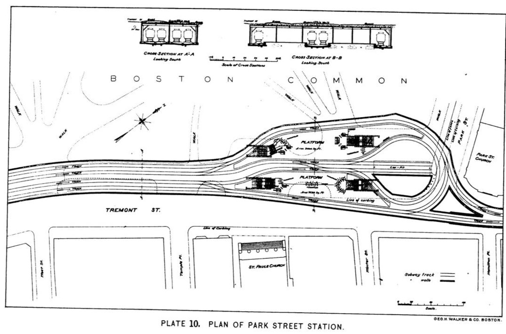 Plan of Park Street Station. Boston Transit Commission report, 1898. |
 Park Street Station, South Bound Platform (Looking South). Boston Transit Commission report, 1898. |
 Park Street Station, South Bound Platform (Looking North). Boston Transit Commission report, 1898. |
Traveling onward, now heading southwestward, we ride through the 100 year old tunnel. The next stop is at Boylston, which has two platforms offset from each other. The southbound platform is an island, with trains operating on the "inner" track. (The outer track is used for emergency storage and formerly led to a duck-under and into the Tremont Street Subway). The northbound platform was an island at one time as well, with the outer track from Tremont Street and the inner track from Arlington. It is now a side platform. An entryway on the northbound platform to a nearby building is closed, as is a passageway connecting the northbound and southbound platforms. The Tremont Street tunnel is still largely intact to its portal at Tremont & Broadway, but has not been used since April 6, 1962. The portal was sealed and a park built in its location around 1975. The former Tremont Street northbound track has two old Boston streetcars parked on it.
 Bellmouth near Van Rensselaer Place, Tremont Street (looking North). Sept 27, 1897. Boston Transit Commission report, 1898. |
 Bellmouths, Four Tracks, and Sub-Subway under Tremont Street, Near Hollis Street (looking South). Boston Transit Commission report, 1898. |
 Plan of Boylston Street Station. Boston Transit Commission report, 1898. |
After leaving Boylston we take sharp turn westward and passes beneath the Back Bay area. Between here and the next station, remnants of two former tunnel portals ("inclines") can be seen, one leading to Charles St. and one to the Public Gardens. (These were closed 2/14/1941 and 9/6/1914 respectively). There is also provision for an extension to Post Office Square. The next stop, Arlington, has two side platforms across from each other. An exit to Berkeley Street is closed, as is a passageway leading to the Public Gardens side of the corner of Arlington & Boylston Streets.
Copley station is next, also two side platforms, is next. Just past the Copley station, the E-Arborway branch subway splits off of the central tunnel, at grade, and heads southwest. See below for the continuation of the E-Arborway route to Prudential and Symphony stations.
Continuing west in the Boylston Street tunnel, the next stop is at Hynes/ICA (formerly Auditorium). An exit, closed in the late 90s, at the east end of the inbound platform leads to a disused street entrance about a half-block north of Massachusetts Avenue along Boylston Street.
The final station in the Boylston Street tunnel is Kenmore. Kenmore station has four tracks and two island platforms. Trains from the B-Boston College branch use the inner tracks, and trains from the C-Cleveland Circle and D-Riverside branches use the outer tracks. Inbound trains from the C and D branches can either merge into the Boylston Street main line or use a loop to re-enter Kenmore Station on the outbound side. Departing Kenmore, the B branch and the C/D branches use different portals and begin their runs on the surface.
The idea of converting the streetcar subway to rapid transit operation, as was done on the Blue Line, was considered as late as the 1960s, and the present Kenmore Station, opened in 1932, was initially equipped with high platforms on the Commonwealth Avenue tracks as preparation for a later conversion. The loop at Kenmore was designed for Beacon Street cars to reverse there, after transferring passengers to the high platform trunk line. The tracks from just east of Kenmore to Blandford St. portal were built on a trestle to bring them up to platform level, with the trestle rising to street level from the level subway floor at the portal. This would allow an extension of the subway out Commonwealth Av. when the new line was built. The clearances in the subway west of the Public Gardens are much more generous than those in the original portion, also a provision for future rapid transit service. The trestle work was removed and the grade raised west of Kenmore in recent years due to heavier cars now in use.
 Kenmore Station Plan, 1932. |
The Arborway line split off of the central subway just past Copley station, with two more subway stops. The first is at Prudential, with two side platforms and a divider between the tracks to prevent crossing over. There is no fare control at this station; all fares are paid on-board the vehicles.
The next stop along the E-Arborway service is at Symphony, another side-platform station with a divider between the tracks. There is a disused crossunder passage between north and southbound platforms, which had been in use until circa 1962.
Photo locations: New Green Line Portal/Viaduct, Canal Street/North Station (Lower Level), North Station (New Subway), North Station (Viaduct), Causeway St., Causeway St. & Lomasney Way, Lomasney Way, Haymarket, Government Center, Park Street, Boylston, Pleasant Street Portal, Arlington, Copley, Hynes/ICA (Auditorium), Kenmore, Prudential, Symphony
A-Watertown Branch
This branch ran split from the B branch at Packard's Corner and continued to Watertown Carhouse mostly by street running. The Watertown Branch was replaced by the MBTA 57 bus in 1969. Tracks remained mostly in place until the mid 1990s.
Photo locations: Brighton/Harvard, Brighton/Cambridge, Cambridge/Eleanor, Cambridge/St. Elizabeth Hospital, Union Square, Oak Square, Tremont/Ricker, Tremont/Marlboro, Tremont/Pembroke, Washington/Galen, Galen Street, Newton Corner, Watertown Yard, MBTA Green-A Watertown, Loc. Unknown
B-Boston College Branch
The Boston College line exits the subway just past the Kenmore station and heads west northwest through Brookline. It runs in a median in Commonwealth Ave., crossing numerous intersections at grade. Traffic signals govern automobile as well as train traffic at the grade crossings. A fence is between the two tracks most of the way to prevent people from jaywalking across the rails. Many small stops exist along the route, each one no more than a small platform with a shelter. About half way up the Boston College line, the line turns southwest. At this point the former Watertown branch used to split off. The Watertown line has not seen service for many years, and it is in the process of being removed. This line was one of the last street running transit routes in the Boston area.
Another mile or two brings the Boston College line to its terminus. Just before the Boston College stop, a set of tracks peels off to the south, linking to the Cleveland Circle and Riverside lines. This line is not used for regular service, but for moving cars between the branches. At Boston College a loop exists to turn cars back, surrounding a small storage yard.
Photo locations: Commonwealth Portal, Commonwealth & Blandford, Commonwealth & Cummington, Commonwealth & Hillside, Commonwealth & Granby, Commonwealth & Essex, Commonwealth & Amory, Commonwealth near Boston University, Boston University East, Boston University Central, Boston University West, Commonwealth & St. Paul, Commonwealth & Pleasant, Commonwealth & Babcock, Commonwealth & Alcorn, Commonwealth & Brighton/Packard's Corner, Commonwealth & St. Lukes, Commonwealth & Fordham, Commonwealth & Chester, Commonwealth & Linden, Commonwealth & Harvard, Commonwealth & Royce, Commonwealth & Griggs, Commonwealth & Redford, Commonwealth & Walbridge, Commonwealth & Allston, Commonwealth & Warren, Commonwealth & Commonwealth Terr., Commonwealth & Summit, Commonwealth & Melvin, Commonwealth & Washington, Commonwealth & Claymoss, Commonwealth & Mt. Hood, Commonwealth & Cummings, Commonwealth & Colborne, Commonwealth & Wilson Park, Commonwealth & Sutherland, Commonwealth & Leamington, Commonwealth & Wallingford, Commonwealth & Chiswick, Commonwealth & Strathmore, Commonwealth & Braemore, Commonwealth & Chestnut Hill, Commonwealth & South, Commonwealth & Wade, Commonwealth & Foster, Commonwealth & Greycliff, Commonwealth & Evergreen Cemetery, Commonwealth & Lake, Boston College, MBTA Green B-Boston College/Commonwealth, Loc. Unknown
C-Cleveland Circle Branch
The Cleveland Circle line also exits its subway portal just past Kenmore. This line runs down the median of Beacon Street, across intersections, like the Boston College line. This route is more scenic and is also one of the first trolley lines in Boston. It passes through Brookline and Newton Heights on its way westward. It also features many small stops along its route until terminating at Cleveland Circle. Past the station the trains loop through Cleveland Circle and through a small yard (which is just north of the Reservoir stop on the Riverside line) before re-entering Cleveland Circle station. Non-revenue tracks connect the B, C, and D, branches at this location.
Photo locations: Beacon & St. Marys, Beacon & Carlton, Beacon & Hawes, Beacon & Kent, Beacon & Powell, Beacon & St. Paul, Beacon & Charles, Beacon & Pleasant, Beacon & Harvard/Coolidge Corner, Beacon & Webster, Beacon & Winchester, Beacon & Summit, Beacon & Marion, Beacon & Brandon Hall, Beacon & Fairbanks, Beacon Between Fairbanks & Westbourne Terrace, Beacon & Westbourne Terrace, Beacon & Washington Sq, Beacon & Winthrop, Beacon & Williston, Beacon & Tappan, Beacon & Regent, Beacon & Corey, Beacon & Dean, Beacon & Kilsyth, Beacon & Englewood, Beacon & Strathmore, Beacon & Ayr, Cleveland Circle, Beacon & Chestnut Hill, Cleveland Circle Yard, Chestnut Hill Avenue - Connection between B & C Lines, MBTA Green C Cleveland Circle/Beacon, Loc. Unknown
D-Riverside Branch
This line, the youngest of the Green Line branches, exits the Subway prior to the Fenway station. From this point, the Riverside line follows an exclusive right of way, with wide sweeping curves on its way to Riverside. The Riverside route is formerly a Boston and Albany railroad branch. It was converted over to rapid transit in the late 1950's. Many of the older stations are still in existence, and are used by the Green Line as transit stations. This is one of the faster parts of the Green Line as trains speed right along, running at up to 50 mph.
There are 11 stops on the journey to Riverside, about 8 to 10 miles from the subway portal. The line can be scenic as it passes through the woods and residential sections of Brookline and Newton. One of the more interesting stations is the Reservoir stop. A yard is adjacent to the station, which is used to store streetcars as well as some work equipment. Some of this work equipment is actually rebuilt PCC and older streetcars. A non revenue rail link also exists from here to the Cleveland Circle and Boston College lines. (The three branches are close enough to walk between.)
Continuing westward, the line passes through wooded areas and the backyards of homes and businesses before ending at Riverside. Here two tracks split and form a loop around a large yard, and shop facility. More streetcars and work equipment is stored in this yard. Most major Green Line repair projects are conducted here. The station platform is located on the eastern side of the loop, before the line turns back to Boston. This station has a large platform with the two tracks running through it.
Photo locations: Fenway, Longwood Ave, Between Longwood & Brookline, Brookline Village, Brookline Hills, Between Brookline Hills & Beaconsfield, Beaconsfield, Near Reservoir, Reservoir, Chestnut Hill, Newton Centre, Crystal Lake (Between Newton Ctr. & Newton Highlands), Between Newton Center & Newton Highlands, Newton Highlands, Cook Junction Loop, Eliot, Waban, Woodland, Between Riverside & Woodland, Riverside, Riverside Yard, MBTA Green D Riverside, Loc. Unknown
E-Heath/Arborway Branch
After Symphony station, the line then exits the subway, and runs down the center median of Huntington Ave. Numerous small stops exist on its route southwest, then southward. Just before Heath Street station, the Arborway line actually begins street running, the last MBTA line to do so. At Heath, there is a loop to turn trains, and is currently the terminal point for service on this branch, about 4 miles from the subway portal. But the tracks continue southward, in the streets to the actual end of the line at Arborway, right next door to the Forest Hills Orange Line station. Service on this part of the line has been suspended since the mid 1980's. Currently it is being debated whether to restore service on the line, or to tear up the tracks.
At Arborway, the line circles around another storage yard. This area has been extensively rebuilt, and is used for storage of some Green Line equipment. The future of this area is also in doubt. There are proposals to build a bus garage in place of the yard.
Photo locations: Huntington Portal, Huntington & Forsyth, Huntington & Greenleaf, Huntington & Northeastern, Huntington & Parker, Museum of Fine Arts, Huntington & Ruggles, Huntington & Evans, Huntington & Ward, Longwood Medical Area, Huntington & Worthington, Huntington & Wigglesworth, Huntington & Francis, Huntington & Brigham Circle, Huntington & Fenwood, Huntington & Wait, Huntington & Frawley, Huntington & Mission, Huntington & S. Huntington, S. Huntington/Riverway, S. Huntington/Back of the Hill, S. Huntington & Colburn, S. Huntington & Heath, S. Huntington & V.A. Hospital, S. Huntington & Evergreen, S. Huntington & Bynner, S. Huntington & Perkins, S. Huntington & Halifax, Centre & Boylston, Centre & Moraine, Centre & Spring Park, Centre & Robinwood, Centre & Lakeville, Centre & Pond, Centre & Grosvenor, Centre & Severns, South & Centre, South & Carolina, South & Child, South & St. Rose, South & Arborway, Arborway/Arborway Yard, MBTA Green E-Arborway/Huntington, Loc. Unknown
Maps
Green Line Operations
Boston's Green Line, which is a streetcar/trolley/light rail line, has a unique signal system. The description below of its aspects and indications is paraphrased from the Rules for Operators and Other Employees of the Light Rail Lines. Wayside signals are used in the central subway (westerly portals to Haymarket), as well as on the Lechmere viaduct between Haymarket and Lechmere, and on the entire D/Riverside line (Highland Branch) which runs on private right-of-way. Wayside signals are not used west of the portals on the B/Boston College, C/Cleveland Circle, and E/Heath St. lines, which have street or central reservation trackage. There are no trippers (stop arms) on the system; operators are responsible for keeping their cars under control and obeying all signals.
Automatic Block Signals
- RED - STOP. Proceed after one (1) minute at restricted speed. (Proceed, prepared to stop short of a train, car, or other obstruction and watch for broken rail or switch not properly lined, not exceeding ten (10) miles per hour to the next signal.) Typically means that the next block is occupied.
- YELLOW - Proceed prepared to stop at the next signal. Typically means that there is one clear block ahead, but the following block is occupied.
- GREEN - Proceed at authorized speed. Typically means that there are at least two clear blocks ahead.
Interlockings and Stations
- RED over RED - STOP and STAY. This aspect is usually found protecting interlockings, and is the equivalent of NYC's home signal. Only an "authorized person" (Inspector or higher grade) may hand flag a car through this aspect.
- YELLOW over YELLOW - COME TO A COMPLETE STOP. Then proceed at restricted speed. Typically found at the entrance to a station, and it means that the station is occupied by the proceeding car. This was added as a safety measure some years ago following a rear-end collision; multiple cars have always been able to enter stations but this aspect adds an additional mandatory stop when the station is occupied.
- VERTICAL YELLOW ARROW - Proceed on through route. This is the equivalent of NYC's home signal indication to take the main route.
- LEFT (or RIGHT) YELLOW ARROW - Proceed on diverging route to the left (or right). This is the equivalent of NYC's home signal indication to take the diverging route.
Mattapan High Speed Line
The Light Rail Division also operates the Mattapan High Speed Line, which is an all-PCC operation. On public maps, it appears as an extension of the MBTA Red Line, however its operations are governed by Green Line rules. This line uses two additional signal aspects:
- FLASHING RED - STOP. Then proceed with caution.
- FLASHING YELLOW - Proceed at reduced speed, prepared to stop.
Route Selection
The switches are operated by "pan" detectors in the overhead, essentially a resistor through which the power is drawn as the car passes. car passes. If the power exceeds a preset limit, a relay is activated, which causes the signal system to set the switch for the right hand option. Otherwise the relay is not activated and the switch is set for the left option. The relay can be triggered by a "Track Switch" switch on the dash of the car which inserts a fixed resistor across the trolley circuit, drawing enough current to activate the switch, or by having the motors powered as the pantograph passes over the pan detector.
Rolling Stock
| Designation | Unit Numbers | Manufacturer | Year Built | Notes | |
|---|---|---|---|---|---|

|
Type 9 LRV | 3900–3923 | CAF USA | 2018–2020 | All active |

|
Type 8 LRV | 3800–3894 | AnsaldoBreda | 1998–2007 | 92 active |

|
Type 7 LRV | 3700–3719 | Kinki Sharyo | 1997 | 15 active |

|
Type 7 LRV | 3600–3699 | Kinki Sharyo | 1986–1988 | 83 active |

|
Standard LRV | 3400–3543 | Boeing Vertol | 1976-1979 | All retired; several units not delivered (went to SF MUNI) |

|
PCC (various subtypes) | 3000–3346 | Pullman Standard | 1941-1945 | Mostly retired; several units still operating MBTA Mattapan-Ashmont Line |
The "Standard" LRVs (3400-3543) were built jointly for Boston and San Francisco in 1976-78 by Boeing-Vertol and feature flat ends, flat panels at the articulation, and a fairly smooth roof line. They use hand control, and run in trains of up to three cars. Of 175 originally ordered, 135 were delivered before the order was cancelled due to various problems with the equipment. Later, San Francisco took some of the undelivered cars before Boston claimed the last 9. Replacement of couplers, air compressors, air conditioning units, wheels, major articulation components and the entire door system made the remaining 55 LRVs reliable but have since been retired.
Type 7s (3600-3719) were built in 1986 and 1997 by Kinki-Sharyo of Japan. Much of the funding for the Type 7 was from lawsuit settlements pertaining to the unreliability of the Boeing-Vertol cars. They are identified by their rounded ends, split windshields, and simple bellows articulation. Two pedal foot control is used along with folding doors. The Type 7s were sucessful from the start and suffered none of the teething pains encountered by the LRVs. The initial hundred were so successful that an additional 20 were odrered ten years later, to help the system through the break-in period for the Type 8s.
The Type 8 car evolved from a need to make the Green Line ADA-accessible. The cars (3800-3899) were built by Breda of Italy. They feature a low-floor design between their motor trucks, including the articulation and its supporting trailer truck. Some teething problems related to derailments of the trailer truck, may have arisen from the design of the truck, which has a separate stub axle for each wheel to allow the low floor to continue through the articulation, a relatively novel design. Type 8s have a narrow flat end and hand control, like the LRVs and are boxier in appearance than either of the two older groups. The Type 7 cars were modified to allow them to run in multiple with Type 8 cars, insuring that most trains will have at least one accessible car.
Photo Gallery
| Five Random Images | ||||
 Image 14117 (270k, 1024x688) Photo by: Joe Testagrose Location: Riverside Yard | 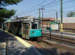 Image 33267 (248k, 1044x788) Photo by: Richard Panse Location: Reservoir |  Image 94672 (204k, 1024x682) Collection of: Joe Testagrose Location: MBTA Green E-Arborway/Huntington, Loc. Unknown |  Image 114986 (291k, 1044x706) Photo by: Jim Colarusso Location: Arborway/Arborway Yard |  Image 115781 (244k, 1024x679) Photo by: Steve Zabel Collection of: Joe Testagrose Location: Eliot |
Page Credits
By Gerry O'Regan.